
September 15 , 2021.
Spain / La Palma : Cumbre Vieja :
Informative update:
The seismic swarm continues under the Cumbre Vieja volcano (La Palma, Canary Islands) with more than 700 localized low magnitude earthquakes.
From 4:18 a.m. (Canary Island time) on Saturday, September 11, 2021, the Canary Islands seismic network operated by the Instituto Volcanológico de Canarias (INVOLCAN) records a new swarm of low-magnitude seismic events in the Cumbre Vieja volcano region . Among the many seismic events detected, more than 700 earthquakes have been located to date. The hypocenters are located under the Cumbre Vieja volcano at depths between 9 and 12 km. The maximum magnitude observed so far has been 3.4 on the Richter scale.
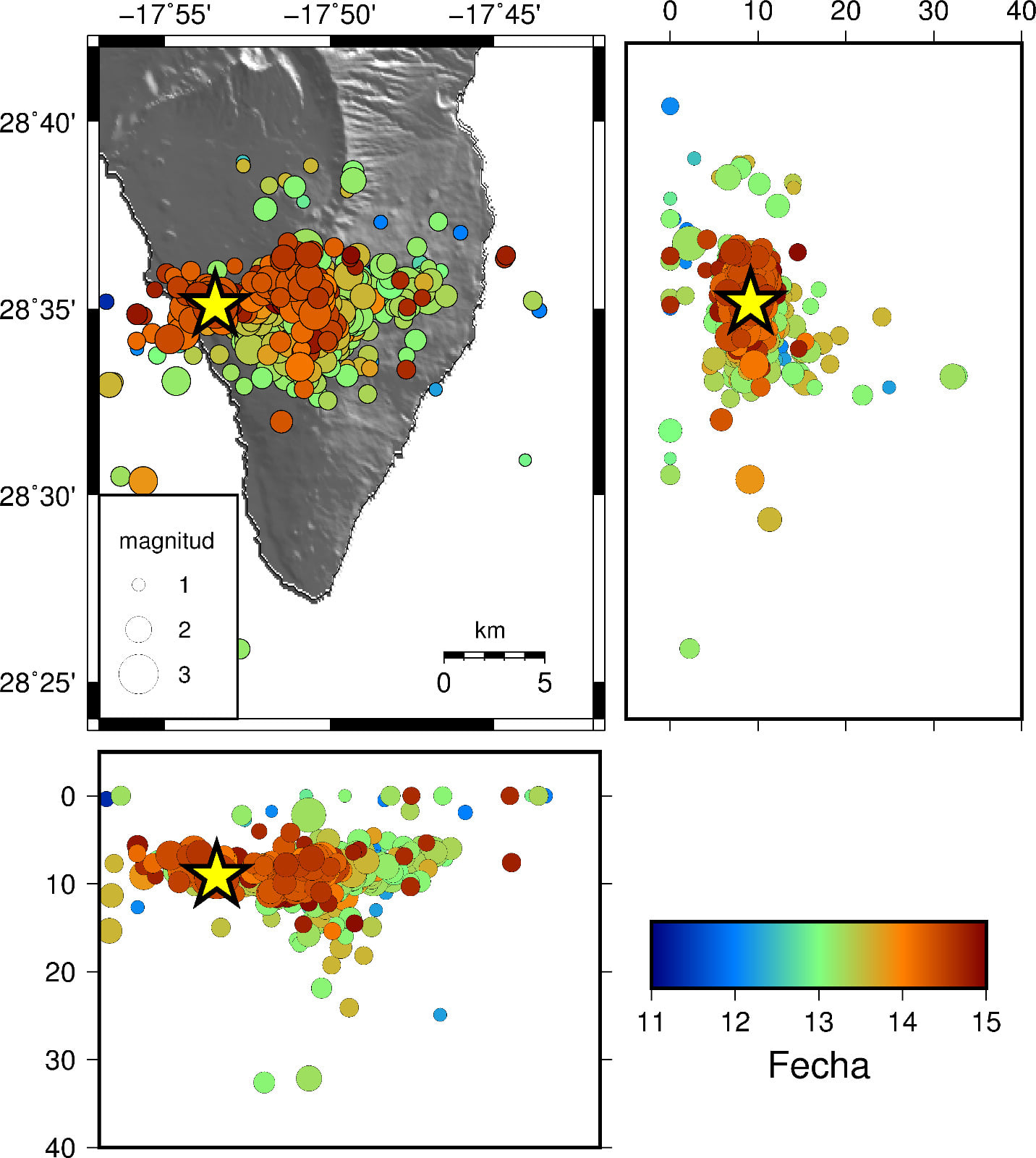
The figure shows the hypocentres of this new swarm in varying colors depending on the date of occurrence. The yellow star indicates the strongest earthquake, with a magnitude of 3.4, recorded today, September 14 at 07:00 a.m. (Canary Island time). A westward migration of seismicity can be observed in recent days.
In recent years, the Cumbre Vieja volcano has experienced 10 seismic swarms including the one that started last Saturday (1 in 2017, 1 in 2018, 5 in 2020 and 3 in 2021). The earthquakes in this latter swarm are shallower compared to previous seismic swarms, when the depth varied between 20 and 30 km. Without a doubt, the current seismic swarm represents a significant change in the activity of the Cumbre Vieja volcano and is linked to a process of magmatic intrusion under the island of La Palma.
INVOLCAN will continue to inform about the evolution of this new seismic swarm under the Cumbre Vieja volcano. Remember that it is not excluded that the seismicity felt in the coming days will intensify, depending on the evolution of the activity.
The current situation of the volcanic traffic light is in YELLOW for the municipalities of El Paso, Los Llanos de Aridane, Mazo and Fuencaliente de la Palma; therefore, keep an eye on the information provided by the corresponding civil protection authorities.
Source and photo : Involcan.
Italy / Sicily , Etna :
Weekly Bulletin from September 06, 2021 to September 12, 2021 (issue date September 14, 2021)
SUMMARY STATEMENT OF ACTIVITY
In view of the monitoring data, it is highlighted:
1) VOLCANOLOGICAL OBSERVATIONS: degassing activity at the level of the summit craters.
2) SEISMOLOGY: Seismic activity of moderate fracturing; the amplitude of the volcanic tremor remained mainly at low levels.
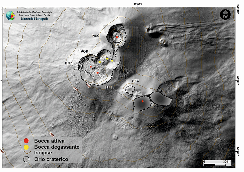
Map of the summit craters of Etna. BN: Bocca Nuova, VOR: Voragine; NEC: northeast crater; SEC: south-eastern crater. The topographic reference frame on which the morphological updates have been superimposed is the DEM 2014 developed by the Aerogeophysical Laboratory – Section Rome 2.
3) INFRASOUND: Moderate infrasound activity.
4) DEFORMATIONS: No significant change to report.
5) GEOCHEMISTRY: SO2 flux at medium-low level
HCl flux appears at an average level.
The flow of CO2 emitted by soils is characterized by a peak which culminates at 12 m.c. displaying very high values. Subsequent measurements indicate a trend reversal.
The partial pressure of CO2 dissolved in water does not show significant variations.
The isotopic ratio of helium appears on average to high values (latest data from 08/31/2021) slightly increasing.
There are no updates for the C / S report.
6) SATELLITE OBSERVATIONS: The thermal activity in the summit area was at a low level.
EXPECTED SCENARIOS
Volcanic activity characterized by degassing and discontinuous explosive activity of summit craters with possible formation of ash clouds and fallout of products of explosive activity in the proximal zone of summit craters at an altitude of about 2700 meters. It is not possible to exclude an evolution of the phenomena towards a more energetic activity.
VOLCANOLOGICAL REMARKS
During the week, the monitoring of the volcanic activity of Etna was carried out by analyzing the images of the surveillance cameras of the INGV, Osservatorio Etneo (INGV-OE).
Due to adverse weather conditions, which affected most of the week, the observation of volcanic activity by cameras was severely limited and discontinuous.
The summit craters, on days of poor visibility, were mainly affected by outgassing.
Volcanic tremor:
The temporal trend of the mean amplitude of the volcanic tremor remained mainly at a low level throughout the week, except for a few fluctuations in the amplitude up to medium values. The location of the source of the tremor is located in the area between the Southeast Crater and the Bocca Nuova, at a depth of about 1000-2900 meters above mean sea level.
Source : INGV.
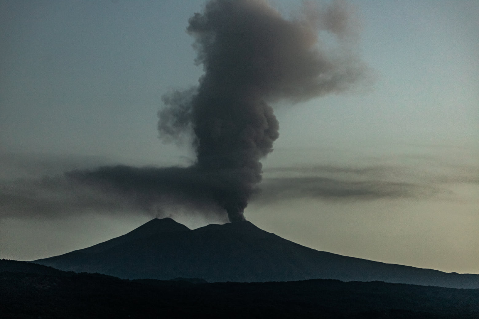
Photo : Guide Alpine Vulcanologiche Etna. ( 26 Juillet 2021).
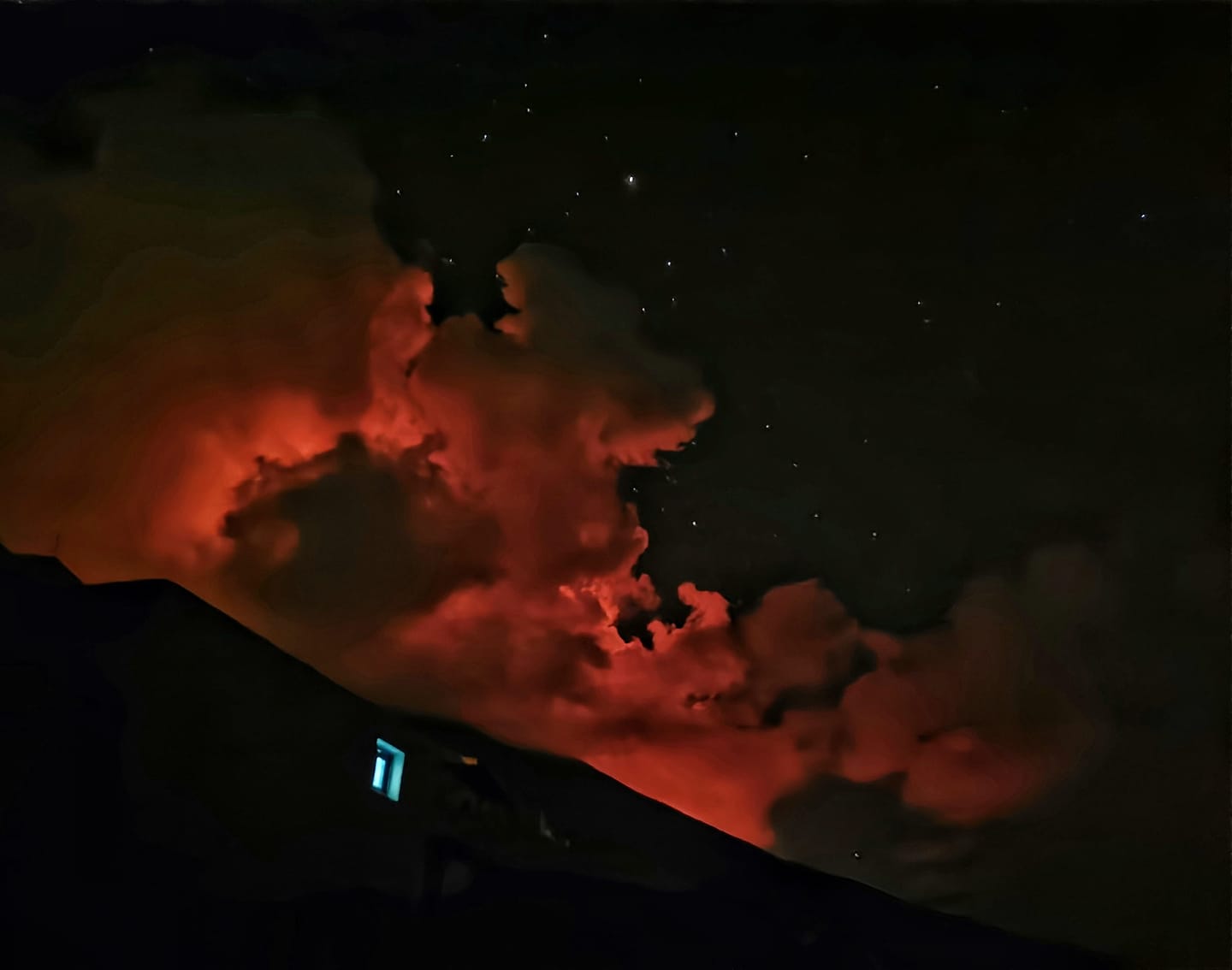
Italy , Stromboli :
Weekly Bulletin from September 06, 2021 to September 12, 2021 (issue date September 14, 2021)
SUMMARY STATEMENT OF ACTIVITY:
In view of the monitoring data, it is highlighted:
1) VOLCANOLOGICAL OBSERVATIONS: During this period, a normal explosive activity of strombolian type was observed, interrupted by the high energy explosive event of September 11. The total hourly frequency of explosions fluctuated between medium-low and medium values (9-15 events / h). The intensity of the explosions was mainly medium and low both in the North crater area and in the Center-South area.
2) SEISMOLOGY: The seismological parameters monitored do not show any significant changes, except for the occurrence at 19:09 GMT on 09/11/2021 of an explosive event of an intensity greater than ordinary activity.
On Saturday September 11 at 9:09 p.m. local time, the INGV surveillance networks recorded an explosive event on the Stromboli volcano of a greater intensity than usual. The event produced a significant emission of matter which passed through the crater terrace as it rolled along the Sciara del Fuoco.
3) DEFORMATIONS: The island’s soil deformation monitoring networks have shown no significant changes over the past week.
4) GEOCHEMISTRY: SO2 flux at medium-low level
The flow of CO2 from the ground to the Pizzo Sopra la Fossa does not show any significant changes.
The weekly average C / S ratio is at low values (C / S = 2.73).
The isotopic ratio of Helium dissolved in the thermal aquifer (latest data dated 06/09/2021) remains at medium-high values.
5) SATELLITE OBSERVATIONS: The thermal activity in the summit area is at a low level.
VOLCANOLOGICAL OBSERVATIONS
During the observation period, the eruptive activity of Stromboli was characterized thanks to the analysis of the images recorded by the surveillance cameras of the INGV-OE (altitude 190m, Punta Corvi, altitude 400m and Pizzo). The explosive activity was mainly produced by 3 (three) eruptive chimneys located in the area of the North crater and by 6 (six) eruptive chimneys located in the area of the Center-South Crater. All the vents are placed inside the depression which occupies the terrace of the crater.
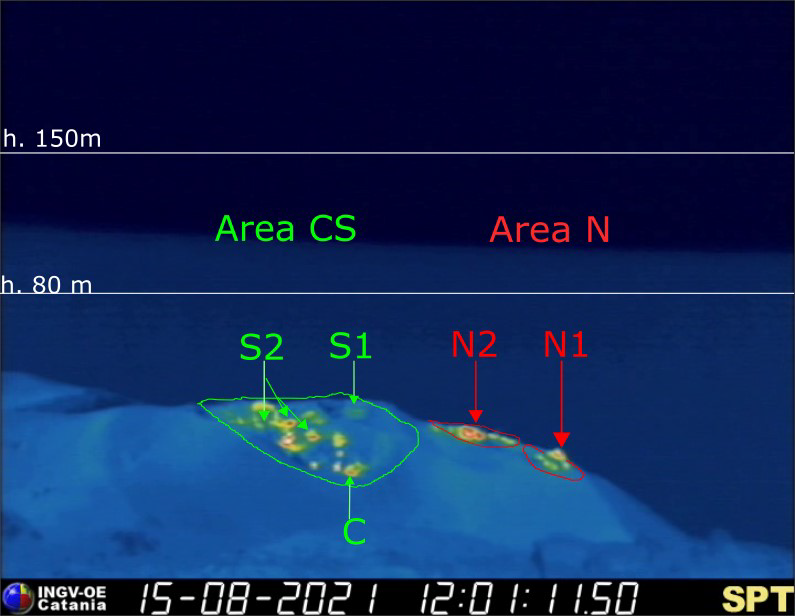
– The crater terrace seen by the thermal camera placed on the Pizzo sopra la Fossa with the delimitation of the areas of the Center-South and North crater (ZONE N, ZONE C-S respectively). Abbreviations and arrows indicate the names and locations of active vents, the area above the crater terrace is divided into three height ranges relating to the intensity of the explosions.
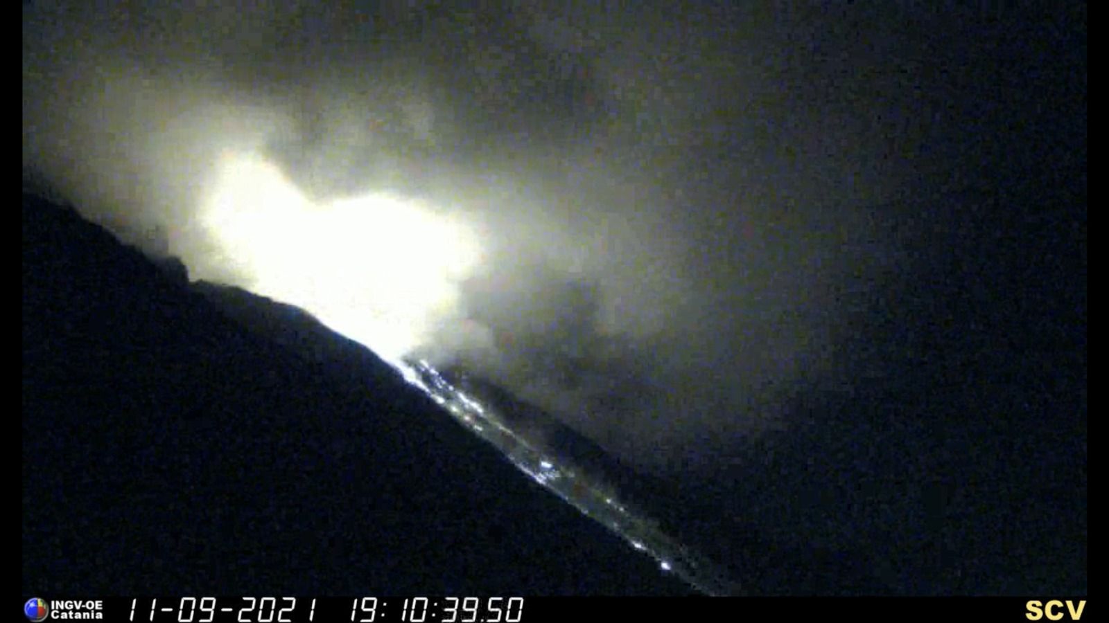
At 7:09 p.m. UTC on September 11, 2021, a high-energy explosive event struck the northern area of the crater terrace. Due to the cloud cover, it was not possible to describe in detail the characteristics of the explosive event. From the few images, it was possible to identify the area of the North crater as an emission point and also the abundant fallout of pyroclastic materials along La Sciara was observed.
Overall, during the week of observation, the N1 crater located in the North zone, with two emission points, produced low intensity explosions (less than 80 m in height) emitting fine materials (ash) mixed to coarse materials (lapilli and bombs). Vent N2 showed low intensity explosive activity (less than 80 m in height) emitting fine material sometimes mixed with coarse material. The average frequency of explosions varied from 2 to 7 events / h.
In the Center-South zone, sector S1 showed constant explosive activity on September 10 and 11 with low-intensity explosions emitting fine materials, while the three vents located in sector S2 produced explosions, sometimes simultaneously, of medium to low intensity (the products of some of the explosions reached 150 m in height) emitting coarse materials mixed with fine materials. Sector C produced an intense degassing activity interrupted by modest explosions emitting coarse materials. The frequency of the explosions varied from 6 to 10 events / h.
Source : INGV.
Photos : INGV , Viaggi e Vulcani.
Kamchatka , Karymsky :
VOLCANO OBSERVATORY NOTICE FOR AVIATION (VONA)
Issued: September 2021
Volcano: Karymsky (CAVW #300130)
Current aviation colour code: ORANGE
Previous aviation colour code: orange
Source: KVERT
Notice Number: 2021-110
Volcano Location: N 54 deg 2 min E 159 deg 26 min
Area: Kamchatka, Russia
Summit Elevation: 1486 m (4874.08 ft)

Volcanic Activity Summary:
A moderate eruptive activity of the volcano continues. According to satellite data, an ash plume is extending for 42 km to the eastsoutheast of the volcano.
This activity continues. Ash explosions up to 19,700-23,000 ft (6-7 km) a.s.l. could occur at any time. Ongoing activity could affect low-flying aircrafts.
Volcanic cloud height:
2000 m (6560 ft) AMSL Time and method of ash plume/cloud height determination: 20210915/0400Z – Himawari-8
Other volcanic cloud information:
Distance of ash plume/cloud of the volcano: 42 km (26 mi)
Direction of drift of ash plume/cloud of the volcano: ESE / azimuth 122 deg
Time and method of ash plume/cloud determination: 20210915/0400Z – Himawari-8
Source : Kvert.
Photo : N. Gorbach, IVS FEB RAS.
Hawaii , Kilauea :
19°25’16 » N 155°17’13 » W,
Summit Elevation 4091 ft (1247 m)
Current Volcano Alert Level: ADVISORY
Current Aviation Color Code: YELLOW
Activity Summary:
Kīlauea Volcano is not erupting. Following the recent intrusion of magma beneath the surface in the area south of Kīlauea caldera, which slowed substantially on August 30, earthquake rates and ground deformation in this area have remained near pre-intrusion levels. Other monitoring data streams, including sulfur dioxide emission rates and webcam views, show no significant changes.
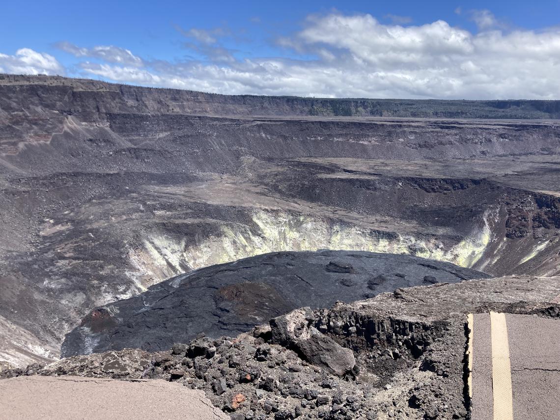
No changes were observed at Kīlauea’s summit during a brief field visit on September 3, 2021. Sunny weather made for spectacular views, though strong winds were blowing. The solidified crust of the lava lake within Halema‘uma‘u—which was active from December 2020 to May 2021—is visible in the lower center of this image. USGS photo by K. Mulliken.
Summit Observations:
Over the past week, 13 small-magnitude earthquakes—all below M2.5—were detected beneath the summit region of Kīlauea. These earthquakes occurred approximately 1-3 kilometers (0.6-1.9 miles) below ground level near Halema‘uma‘u. There has been no notable seismic activity in the vicinity of the the recent intrusion. Since August 30, tiltmeters have not detected any substantial ground deformation in the summit region. These observations suggest that the supply of new magma to the intrusion has slowed or stopped.
Sulfur dioxide (SO2) emission rates remain at very low levels that have persisted since May 2021, when the most recent summit eruption ended. The latest SO2 emission rates—measured on September 8—were 55 tonnes per day, close to levels associated with the non-eruptive period from late 2018 to late 2020 (less than 50 tonnes per day). The present rates are significantly lower than the average of over 800 tonnes per day that prevailed from mid-February to mid-April when the Kīlauea summit eruption was ongoing.
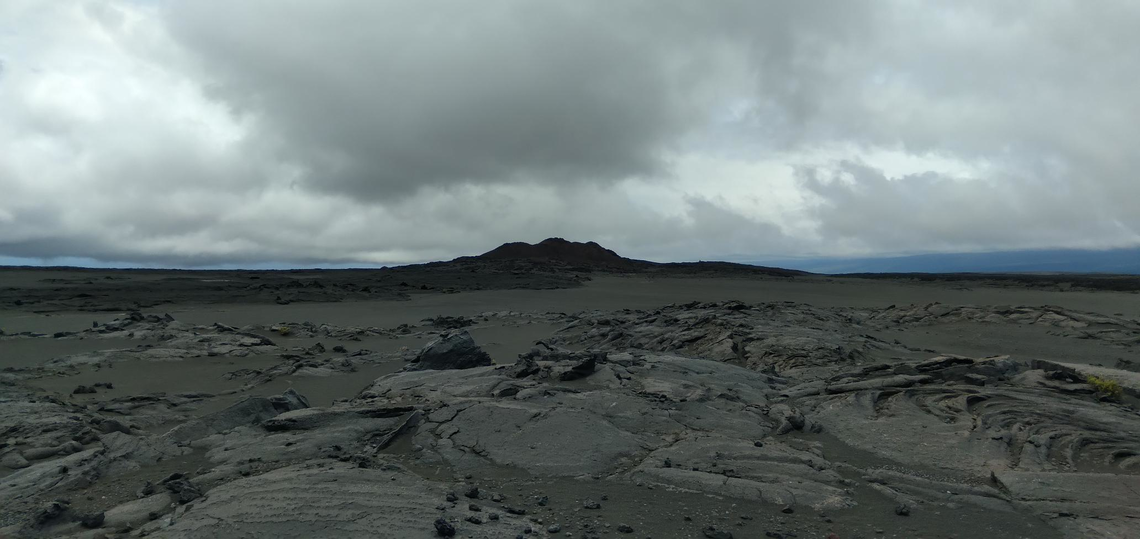
View to the southwest from HVO station HRPKE, showing Pu‘ukoa‘e on Kīlauea’s Southwest Rift Zone in the background. Pu‘ukoa‘e formed during an eruption more than 200 years ago; lava flows from the December 1974 eruption of Kīlauea’s Southwest Rift Zone—which are visible in the foreground—flowed southwest towards Pu‘ukoa‘e, with one lava flow from the eruption stopping at Pu‘ukoa‘e. USGS photo by P. Nadeau.
Halemaʻumaʻu Lava Lake Observations:
The surface of Halema‘uma‘u lava lake, which was actively erupting from December 2020 through May 2021, remains covered by stagnant and solidified lava crust. Currently, there are no indications of the Halema‘uma‘u vent resuming eruption.
East Rift Zone Observations:
No unusual activity has been noted in the Kīlauea East Rift Zone. Ground deformation monitors indicate that the upper East Rift Zone—between the summit and Puʻuʻōʻō—is refilling at rates similar to those measured over the past 2 years and before the December 2020–May 2021 eruption in Halemaʻumaʻu. SO2 and hydrogen sulfide (H2S) emissions from Puʻuʻōʻō were below instrumental detection levels when last measured on January 7, 2021.
Source : HVO
Photos : USGS / K. Mulliken. USGS / P. Nadeau.


No comment yet, add your voice below!