
August 28 , 2021 .
Indonesia , Merapi :
Report on the activity of Mount Merapi from August 20 to 26, 2021
RESULT OF OBSERVATIONS
Visual
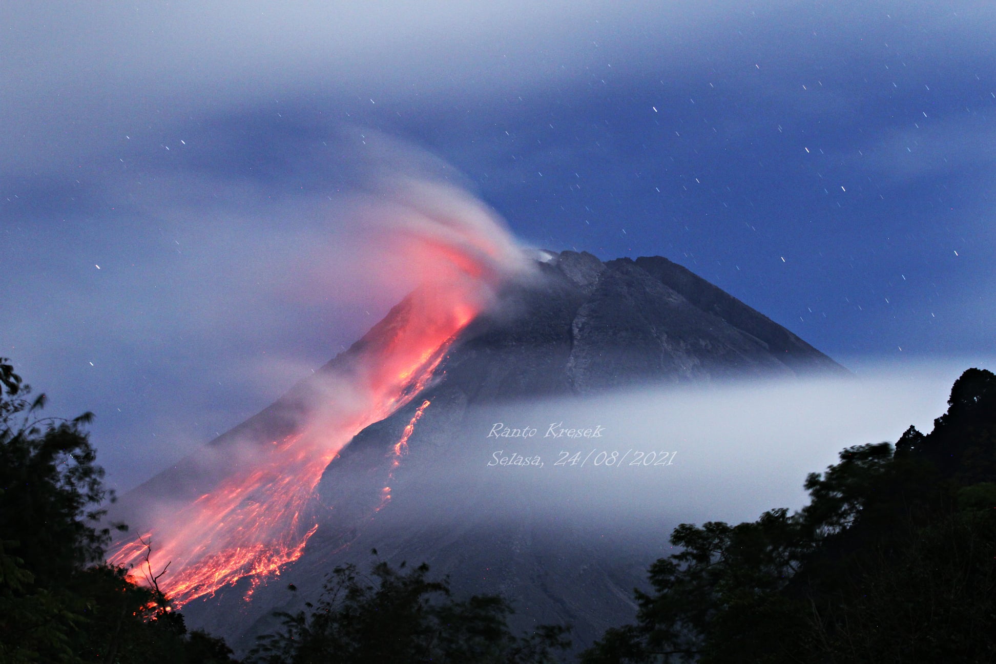
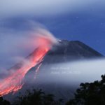
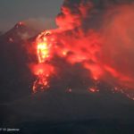
The weather around Mount Merapi is generally sunny in the morning and evening, while it is foggy in the afternoon. White fumes, weak to thick, of low pressure and 250m high were observed from the Mount Merapi observation post in Selo on August 20, 2021 at 05:30 WIB.
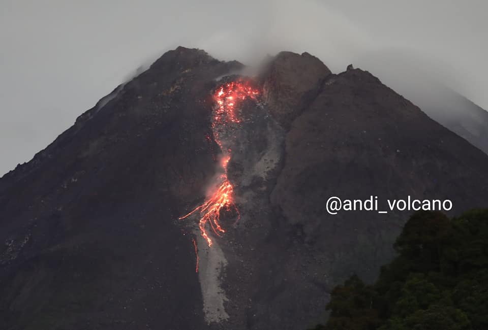
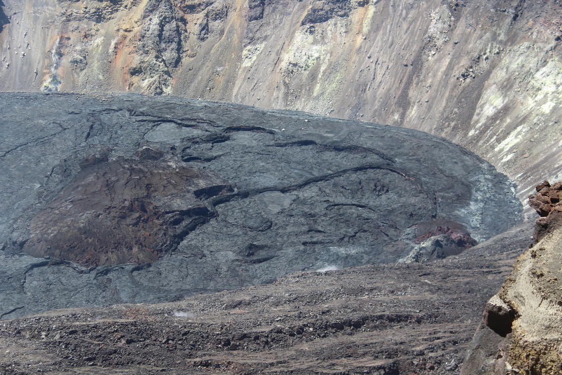
This week, there were 2 hot avalanche clouds to the southwest with a maximum slide distance of 2000 m. Lava avalanches have been observed 211 times to the southwest with a maximum slide distance of 2000 m.
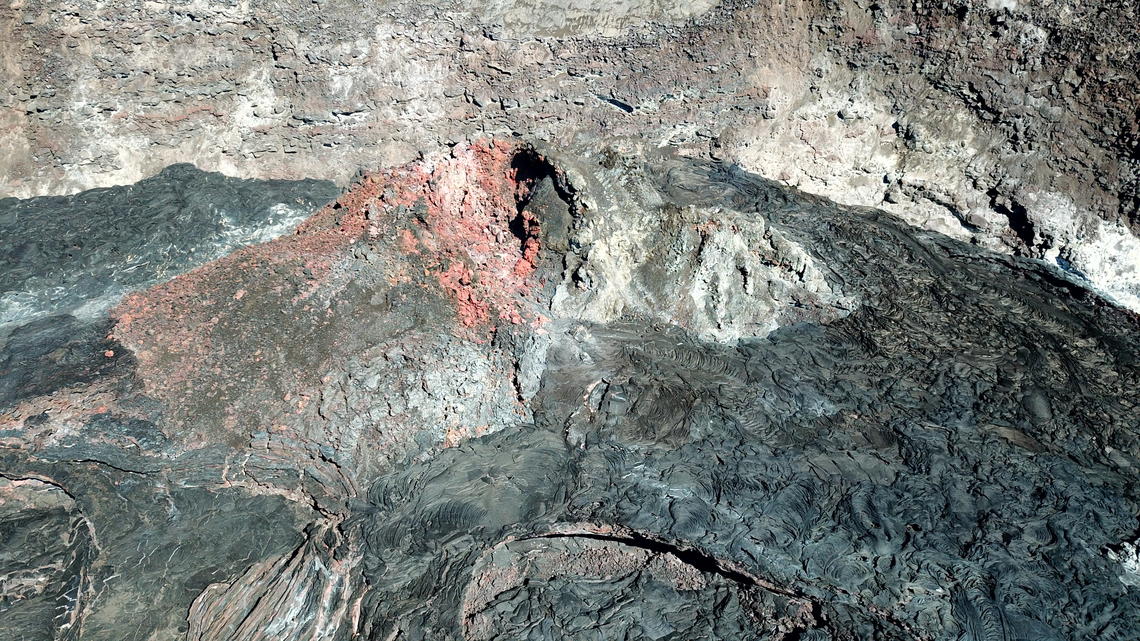
It was observed that there were morphological changes in the southwest lava dome, namely that the height of the dome increased by about 3 m. While the central dome is relatively fixed. The volume of the southwest lava dome is 1,400,000 m3 and the central dome is 2,831,000 m3. From the results of aerial photos taken with drones on August 25, 2021, it is shown that in general the morphology of the two domes is relatively fixed. Morphological changes occurred at the top of the Southwest Lava Dome, the active magma extrusion site at that time.
Seismicity
This week, the seismicity of Mount Merapi showed
2 hot avalanche clouds (AP),
1 shallow volcanic earthquake (VTB),
15 low frequency earthquakes (LF),
19 multi-phase earthquakes (MP),
1,973 Avalanche earthquakes (RF),
100 emission earthquakes (DG),
5 tectonic earthquakes (TT).
This week’s seismicity intensity was lower than last week.
Deformation
The deformation of Mount Merapi which was monitored using EDM and GPS this week showed no significant changes.
Rain and lahars
This week, it rained at the Mount Merapi observation post with an intensity of 67 mm / hour for 25 minutes at Kaliurang post on August 21, 2021. There were no reports of lahars or additional flow in the mountains. rivers that take their source on Mount Merapi.
Conclusion
Based on the results of visual and instrumental observations, it is concluded that:
The volcanic activity of Mount Merapi is still quite high in the form of effusive eruption activity. The status of the activity is defined in the “SIAGA” level.
Source : BPPTKG.
Photos : Ranto Kresek , Andi _Volcano.
Alaska , Great Sitkin :
52°4’35 » N 176°6’39 » W,
Summit Elevation 5709 ft (1740 m)
Current Volcano Alert Level: WATCH
Current Aviation Color Code: ORANGE
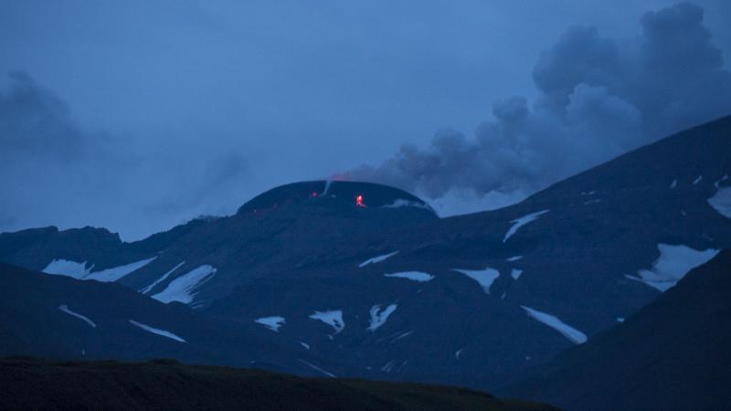
The eruption of lava in the summit crater of Great Sitkin Volcano continued over the past week. Satellite data showed that the new lava dome widened from approximately 860 m (~2800 ft) across on August 19 to about 880 m (~2900 ft) on August 24. Steam and gas plumes have been visible to local observers and in satellite images, but no explosive activity or ash emissions have been detected. Sulfur dioxide plumes were detected daily by satellite throughout week. Small earthquakes have been detected that are likely associated with the lava effusion.
There is no indication of how long lava effusion will continue during the current eruption, and it is possible that explosive activity could occur with little or no warning.
Great Sitkin Volcano is monitored by local seismic and infrasound sensors, satellite data, web cameras, and remote infrasound and lightning networks.
Great Sitkin Volcano is a basaltic andesite volcano that occupies most of the northern half of Great Sitkin Island, a member of the Andreanof Islands group in the central Aleutian Islands. It is located 43 km (26 miles) east of the community of Adak. The volcano is a composite structure consisting of an older dissected volcano and a younger parasitic cone with a 3-km-diameter summit crater. A steep-sided lava dome, emplaced during the most recent significant eruption in 1974, occupies the center of the crater. That eruption produced at least one ash cloud that likely exceeded an altitude of 25,000 ft above sea level. A poorly documented eruption occurred in 1945, also producing a lava dome that was partially destroyed in the 1974 eruption. Within the past 280 years a large explosive eruption produced pyroclastic flows that partially filled the Glacier Creek valley on the southwest flank.
Source : AVO.
Photo : Ward, Dave.
Philippines , Taal :
TAAL VOLCANO BULLETIN 28 August 2021 8:00 AM
In the past 24-hour period, the Taal Volcano Network recorded sixty-seven (67) volcanic earthquakes, including thirty-two (32) volcanic tremor events having durations of one (1) to two (2) minutes, thirty-five (35) low-frequency volcanic earthquakes, and low-level background tremor that has persisted since 07 July 2021.
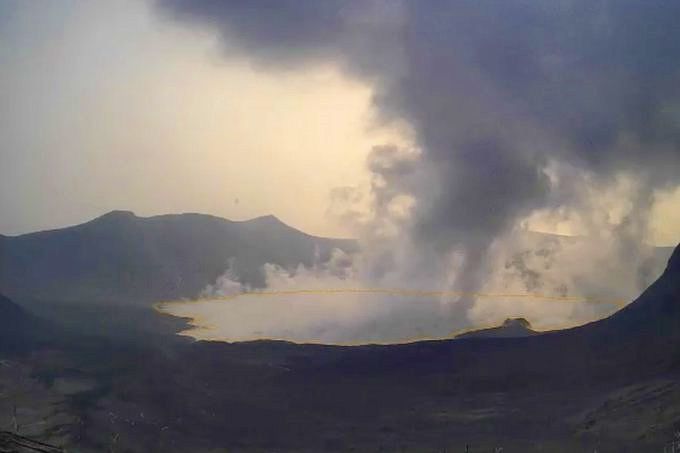
Activity at the Main Crater was dominated by upwelling of hot volcanic fluids in its lake which generated plumes 900 meters tall that drifted southwest. Sulfur dioxide (SO2) emission averaged 3,848 tonnes/day on 25 August 2021. Based on ground deformation parameters from electronic tilt, continuous GPS and InSAR monitoring, Taal Volcano Island has begun deflating in April 2021 while the Taal region continues to undergo very slow extension since 2020.
Alert Level 2 (Increased Unrest) prevails over Taal Volcano.
Source et photo : Phivolcs
Hawaii , Kilauea :
19°25’16 » N 155°17’13 » W,
Summit Elevation 4091 ft (1247 m)
Current Volcano Alert Level: ADVISORY
Current Aviation Color Code: YELLOW
This close-up Unoccupied Aircraft Systems (UAS) photo of the inactive western fissure within Halema‘uma‘u was captured on Thursday, June 3, 2021, at the summit of Kīlauea. The recent pause in the eruption has allowed the USGS Hawaiian Volcano Observatory (HVO) UAS pilots to safely photograph the eruptive features from new angles. For scale, the tallest parts of the western fissure stand approximately 19 m (62 ft) above the surrounding Pāhoehoe flows in this view.
KĪLAUEA INFORMATION STATEMENT
Kīlauea volcano is not erupting. The US Geological Survey’s Hawaiian Volcano Observatory (HVO) detected a resumption in earthquake activity and ground deformation beneath the south part of Kīlauea summit caldera, within Hawaiʻi Volcanoes National Park. The rate of ground deformation began increasing again around 6:00 p.m. HST on August 26 and was followed by increased earthquake activity after 8:30 p.m. The renewed activity occurred in approximately the same location as the August 23-25 earthquake swarm—within and south of Kīlauea caldera. The combination of these observations indicate a second pulse of intrusive activity.
Most earthquakes in this renewed swarm were located 1–3 km (0.6–1.8 miles) beneath the surface, similar to the initial swarm. Approximately 200 earthquakes have been recorded since 8:30 p.m. on August 26, less than half of the number of earthquakes detected in the initial August 23–25 swarm. The largest recorded earthquake was magnitude 2.8, with the majority of earthquakes less than magnitude 1. Between 8:30 p.m. on August 26 and 5 a.m. on August 27, small earthquakes occurred at 16 detected earthquakes per hour, with a peak rate of 24 detected earthquakes per hour just after midnight. Since 5:00 a.m. on August 27, the average seismicity rate has dropped to about six detected earthquakes per hour.
As of this statement, both earthquake and ground deformation rates in Kīlauea’s summit region appear to be decreasing. In addition, there has been no indication of upward migration of earthquakes toward the surface or change in deformation that would indicate shallowing of the source intrusive activity. Accordingly, Kīlauea’s Volcano Alert Level and Aviation Color Code remain at ADVISORY/YELLOW.
While the activity has slowed down as of the morning of August 27, additional intrusion pulses are possible. Any potential eruptive activity related to these events would be entirely within Hawaiʻi Volcanoes National Park and localized within undeveloped areas, well away from infrastructure such as roads. HVO continues to monitor this situation and will issue additional messages and Volcano Alert Level changes if warranted by changing activity.
Source : HVO.
Photos : USGS , USGS / M. Zoeller.
Japan , Fukutoku-Okanoba :
The shape of the volcano has partially changed. The western island remains unchanged, but the eastern flank has been partially submerged by sea erosion.
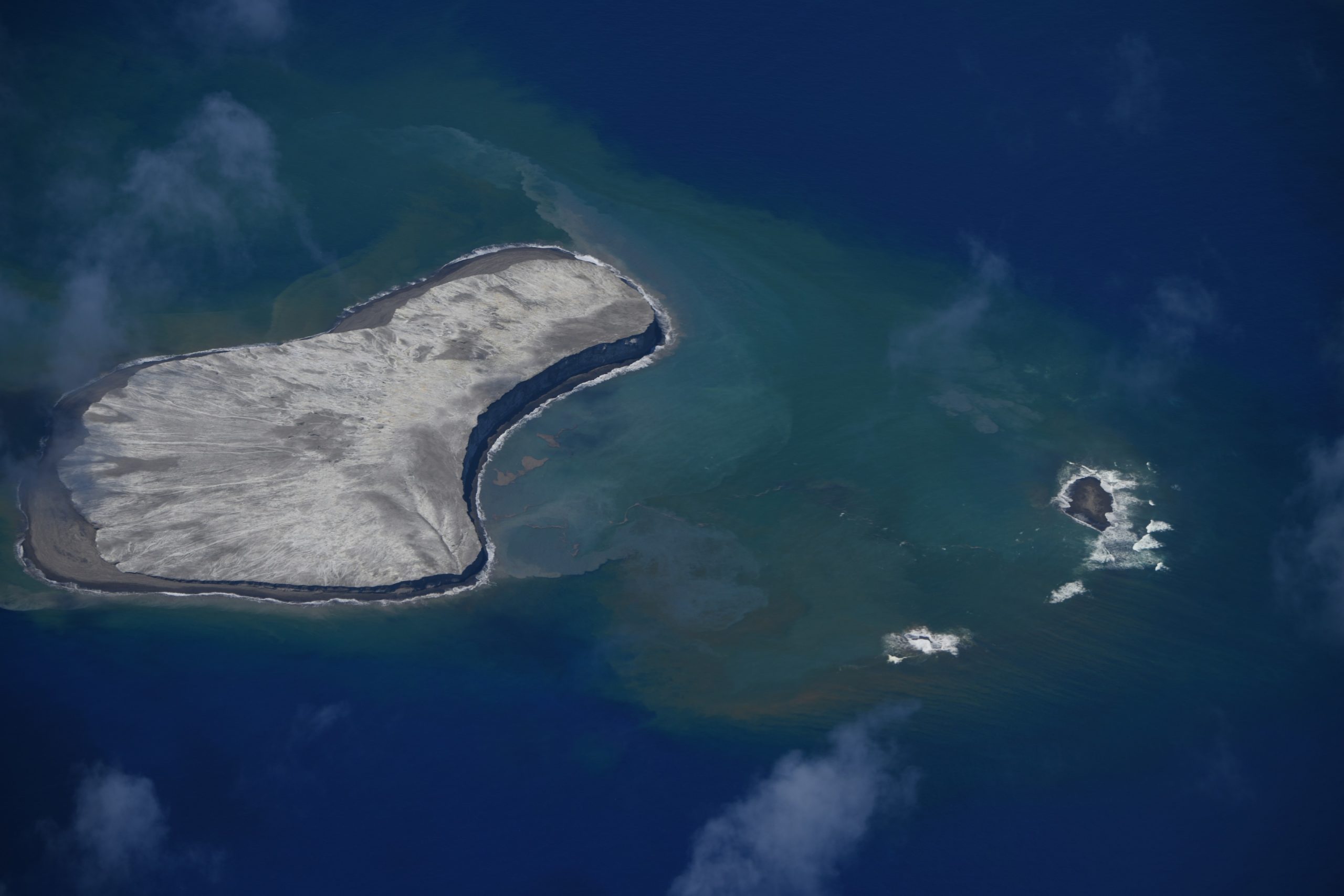
Kita Fukutoku Caldera is a 16 km x 10 km caldera located southeast of Kita Fukutoku. A new mountain body is developing in the southern half of the caldera due to activity from Fukutoku Okanoba and other central crater hills. One of the lifts from Kita Fukutoku and South Iwo Jima develops at the edge of the caldera, indicating that the activity of the Kita Fukutoku caldera is older than that of these volcanoes. Underwater volcanic activity has often been observed at Fukutoku-Okanoba (shallowest water depth is 25m), which is the central hill of the crater. Niijima Island has formed three times so far, but all of them have been submerged. It is mainly composed of andesite (SiO2 61%). As a result of the study of the topography of the seabed from March 1 to 4, 2010, the summit of Fukutoku-Okanoba has an elliptical shape extending in a North-East-South-East direction for 1.5 km x 1 km and is located on the north side of the summit. It has been revealed that several craters with a diameter of about 200 m and a depth of about 30 m formed by the eruptions of 2005 and 2010 are connected over 600 m.
Source : kaiho.mlit.go.jp
Photo : kaiho.mlit.go.jp
Guatemala , Santiaguito :
Activity:
The OVSAN observatory of the Santiaguito volcano reports degassing at the level of the Caliente dome which is moving in a southwest direction. Weak to moderate explosions were observed which expel white and gray columns at a height of 3,400 meters above sea level (11,155 feet) which are scattered to the west and southwest. Weak to moderate boulder and ash avalanches continue to generate on the western, southwest and southern flanks, some reaching the base of Dome Caliente.
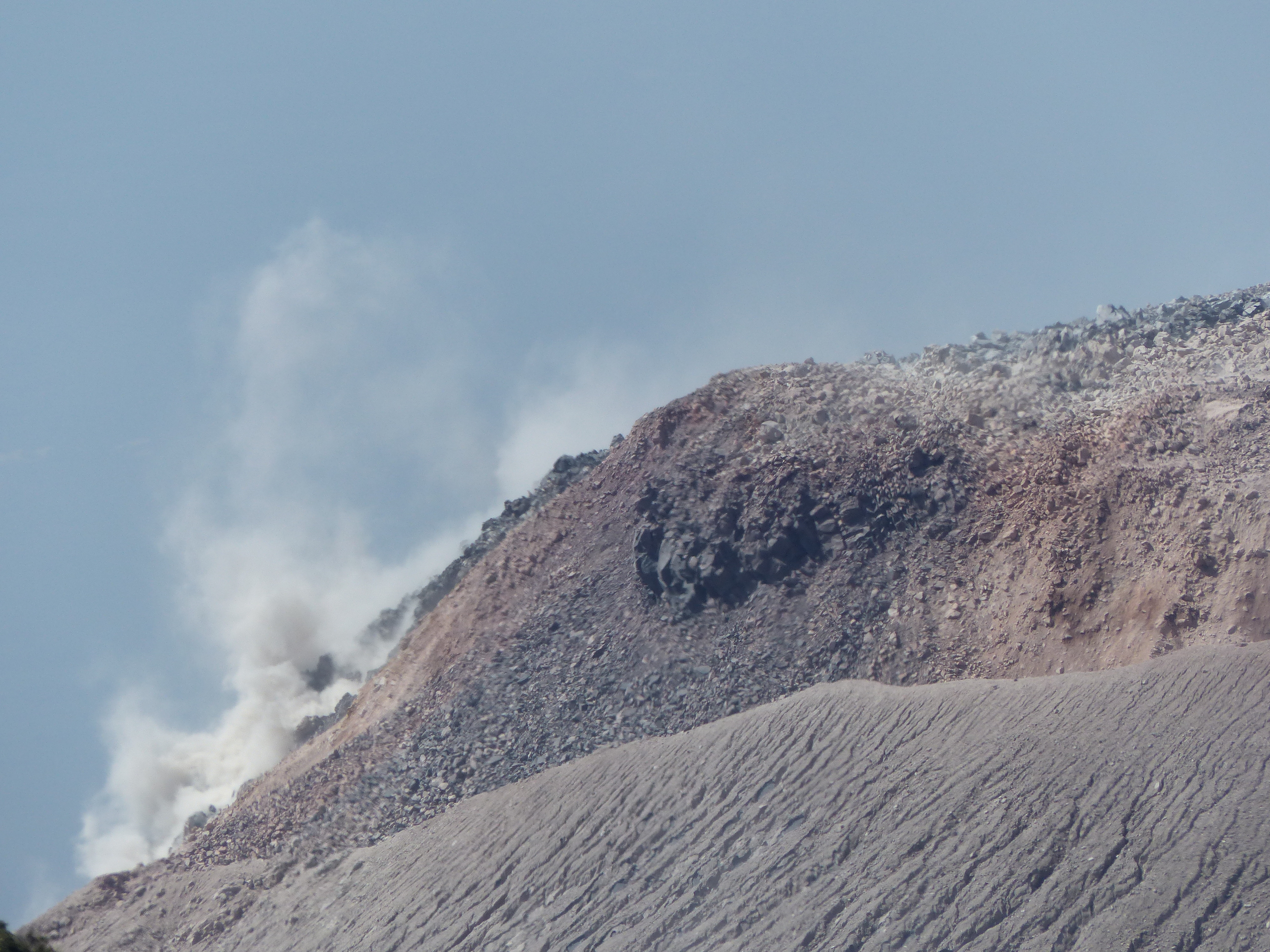
A slight degassing noise similar to that of an airplane turbine can be heard due to the pressure of the magmatic gases. Due to the extrusion of block lava into the Caliente Dome in a West-South-West direction and unstable materials in the crater, there is a likelihood of moderate to heavy pyroclastic flows, so do not stay close or inside the channels. rivers near the slopes of the volcano.
Source : Insivumeh
Photo : G Vitton


No comment yet, add your voice below!