
June 22 , 2021.
Italy / Sicily , Etna :
Communication on ETNA’s activity, June 22, 2021, 04:35 (02:35 UTC).
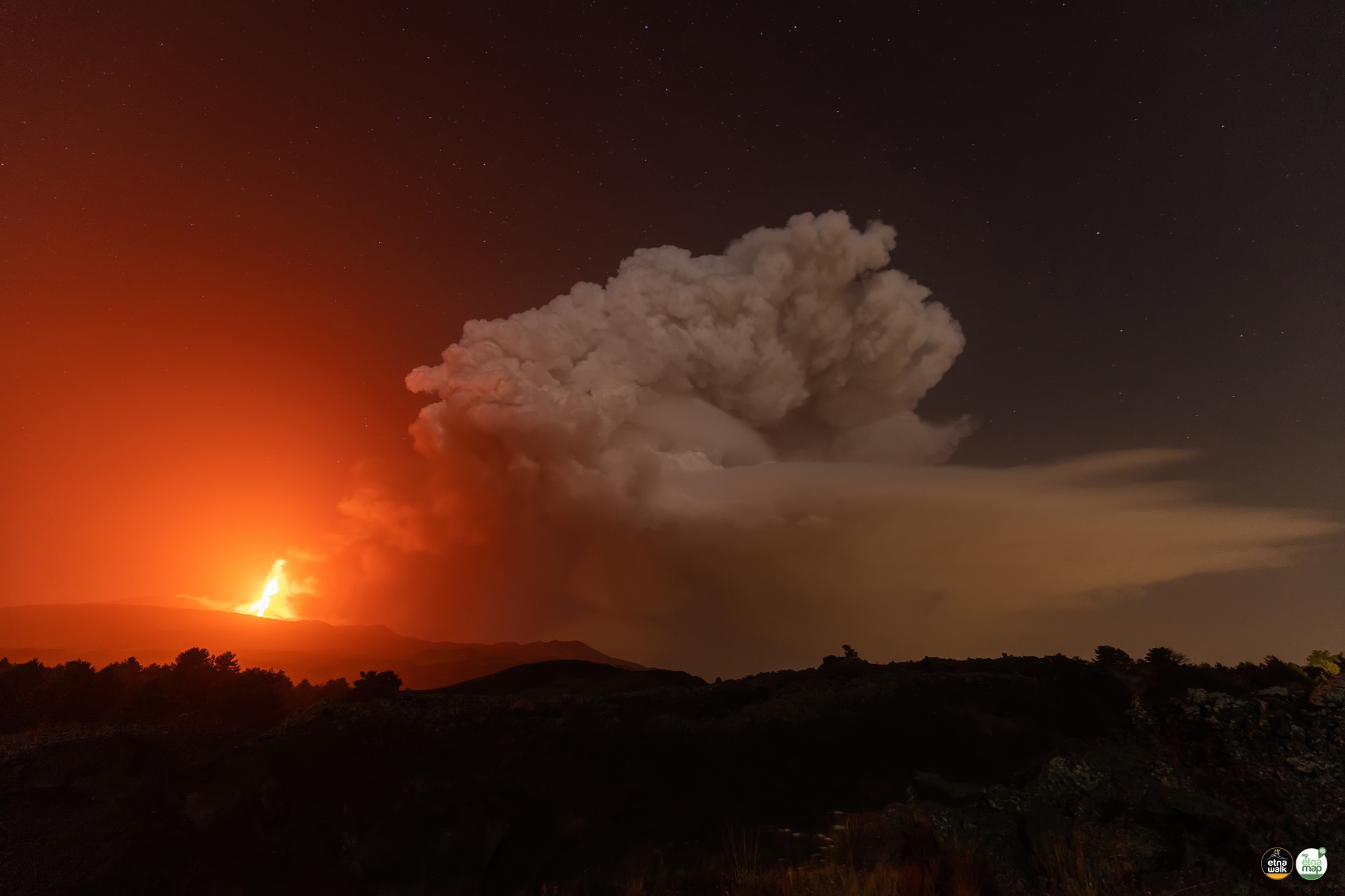
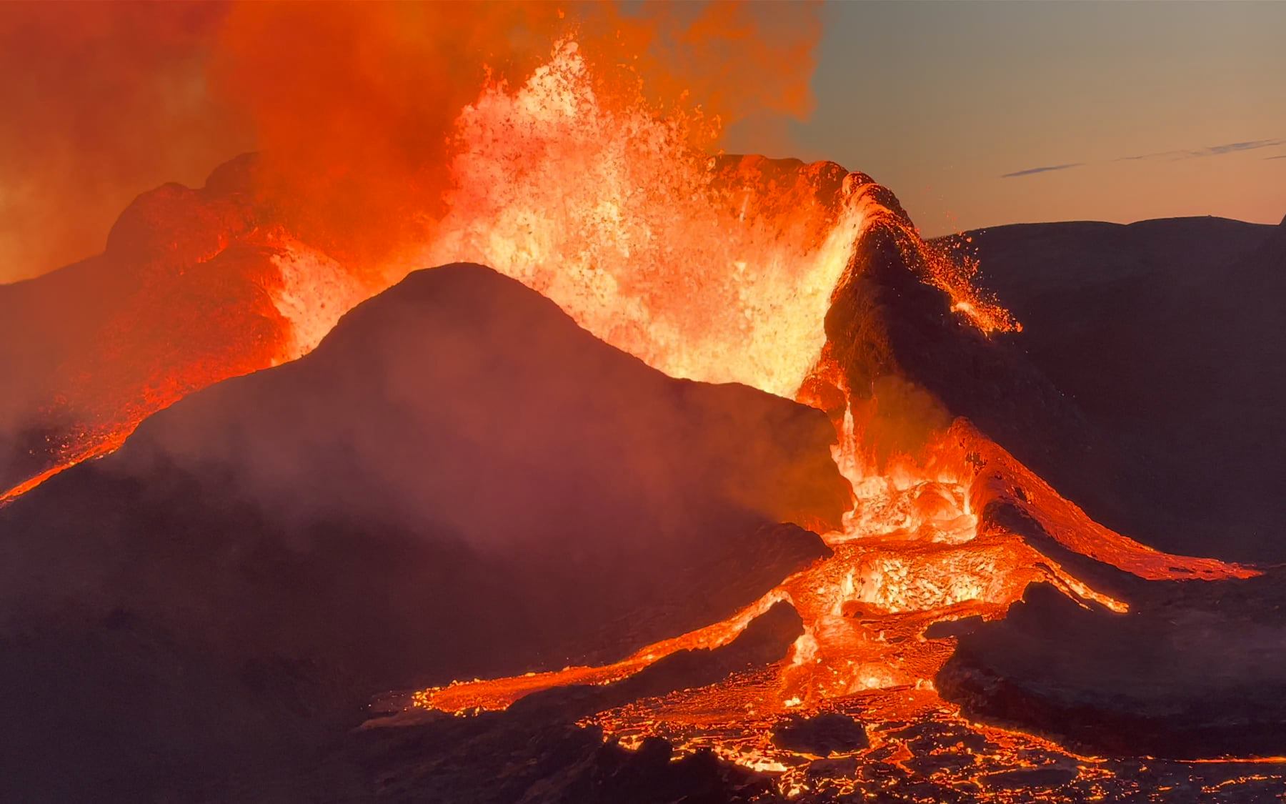
The National Institute of Geophysics and Volcanology, Osservatorio Etneo, announces that from the images of the surveillance cameras, around 02:15 UTC, it was possible to observe the resumption of Strombolian activity at the level of the Southeast Crater .
From around 02:00 UTC an increase in the mean amplitude of the volcanic tremor was observed, whose values are currently at the high level. The centroid of volcanic tremor sources is located in the Southeast Crater area at an altitude of about 2900-3000 m above sea level. Infrasound activity remains at low levels. The sources of the tremor are located with events located at the Southeast Crater.
Communication on ETNA’s activity, June 22, 2021, 05:03 (03:03 UTC).
The National Institute of Geophysics and Volcanology, Osservatorio Etneo, announces that from around 02:30 UTC, a sudden increase in Strombolian activity is observed with fallout of products on the outer slopes of the Southeast Crater. In addition, the continuous emission of ash produced by the current activity, according to the forecast model, is dispersed in the northeast direction.
The trend of increasing the average amplitude of volcanic tremor continues in the high value range. The infrasonic activity also intensified in both the rate of occurrence and the energy of infrasonic events. The sources of volcanic tremor and infrasound events are located in the Southeast Crater.
At present, no significant change is observed in the distortion signals recorded by inclinometric and GNSS networks.
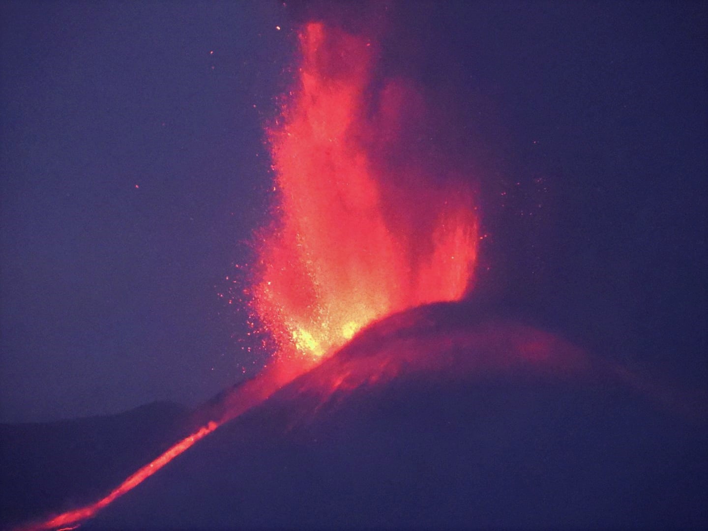
From 02:55 UTC, the Strombolian activity of the Southeast Crater turned into a lava fountain. In addition, there is an overflow of lava to the southwest.
Communication on ETNA’s activity, June 22, 2021, 06:13 (04:13 UTC).
The National Institute of Geophysics and Volcanology, Osservatorio Etneo, reports that from the images of the surveillance cameras, it is observed that the explosive activity at the Southeast Crater has ceased, the lava overflow that was spreading in Southwest direction always seems weakly powered.
The average amplitude of the volcanic tremor, after reaching the maximum value at 03:20 UTC, underwent a rapid decrease until reaching the average level. The source of the volcanic tremor remains located in the Southeast Crater area at an altitude of about 2900 m. Infrasound activity also decreased both in the number of events and in their magnitude.
The stations of the inclinometric network recorded modest variations. No significant change is observed in the signals acquired by the GNSS network.
Further updates will be communicated shortly.
Source : INGV.
Photos : Boris Behncke , Marco Restivo / Giuseppe Distefano / etna walk
Peru , Sabancaya :
Analysis period: June 14, 2021 to June 20, 2021, Arequipa, June 21, 2021.
Alert level: ORANGE
The Geophysical Institute of Peru (IGP) reports that the eruptive activity of the Sabancaya volcano remains at moderate levels, that is to say with the recording of an average of 80 daily explosions, with columns of ash and gas up to an altitude of 2.3 km above the summit of the volcano and their consequent dispersion. Therefore, for the following days, no significant change is expected in eruptive activity.
The IGP recorded and analyzed the occurrence of 1,026 earthquakes of volcanic origin, associated with the circulation of magmatic fluids within the Sabancaya volcano. An average of 80 explosions was recorded daily. During this period, Volcano-Tectonic (VT) earthquakes associated with rock fractures were located mainly in the North-East and North-West of Sabancaya and presented magnitudes between M1.8 and M3.5.
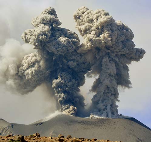
The monitoring of the deformation of the volcanic structure using GNSS techniques (processed with fast orbits) does not present any significant anomalies. However, in general, an inflation process was observed in the northern sector (around the Hualca Hualca volcano). Visual surveillance identified columns of gas and ash up to an altitude of 2.3 km above the summit of the volcano, which were scattered towards the South-East, South, East and North-East sectors of the volcano. Sabancaya. Satellite recordings have identified the presence of 7 thermal anomalies (maximum value of 15 MW) associated with the presence of a lava body on the surface of the volcano’s crater.
RECOMMENDATIONS
• Keep the volcanic alert level in orange.
• Do not approach within a radius of 12 km from the crater.
Source : IGP.
Photo : IGP .
Alaska , Great Sitkin :
52°4’35 » N 176°6’39 » W,
Summit Elevation 5709 ft (1740 m)
Current Volcano Alert Level: ADVISORY
Current Aviation Color Code: YELLOW
Seismicity has remained at low levels over the past day. No eruptive activity was observed in satellite views or in webcam images. Slightly elevated surface temperatures were observed in satellite data and are likely a result of still hot eruptive material in the summit crater associated with the May 25 eruption.
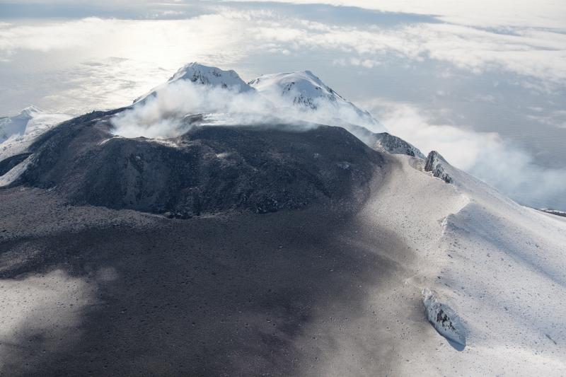
Great Sitkin summit crater taken during June 11 overflight.
The prognosis for renewed eruptive activity is uncertain, although the ongoing quiescence is suggestive of a gradual return to normal background conditions. It remains possible for the level of unrest at the volcano to change quickly, and if so, additional explosive events could occur in the coming days, weeks or months. AVO is monitoring the volcano closely and will report on significant changes and observations in monitoring data should they occur.
Great Sitkin volcano is monitored by local seismic and infrasound sensors, satellite data, web cameras, and remote infrasound and lightning networks.
Source : AVO
Photo : Loewen, Matt , Alaska Volcano Observatory / U.S. Geological Survey.
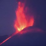
Iceland , Geldingadalur / Fagradalsfjall :
Reykjanes eruption: sacrificed road, protected city.
Icelandic authorities will not attempt to divert lava from the ongoing eruption in Geldingadalur from the adjacent Suðurstrandarvegur road. The eruption has been going on for over three months now, and its growing lava field is expected to hit the road in one to three weeks. Rather, efforts will be focused on protecting the nearby town of Grindavík and the Svartsengi power plant if necessary.
« We have had many meetings over the past few days and weeks and assess whether it is possible to protect Suðurstrandarvegur, » Fannar Jónasson, mayor of Grindavík, told RÚV. “After careful consideration, it was decided that this would not work, both for technical reasons, due to time, and most importantly due to cost. Fannar says authorities are now looking further to see what infrastructure will need to be protected if the eruption continues for many months. “If this continues for a few months or years, we may have to react so that it does not sink towards Svartsengi [power plant] or even Grindavík. We want to have enough time to prevent this and create powerful obstacles. This wouldn’t happen for a long time, but structures are still being designed that would provide protection in this case.

While geologists say there is no way to predict how long the Reykjanes eruption will last, several have said it could be a shield volcano in the making. Shield volcanoes are formed by long, slow eruptions like that of Geldingadalur where lava forms a gently sloping volcano over time. Such eruptions have rarely occurred in Iceland since the end of the Ice Age, but they can last for years.
Source : icelandreview.com
Photos : Guy de Saint Cyr , Sylvain Chermette / André Laurenti.
Ecuador , Reventador :
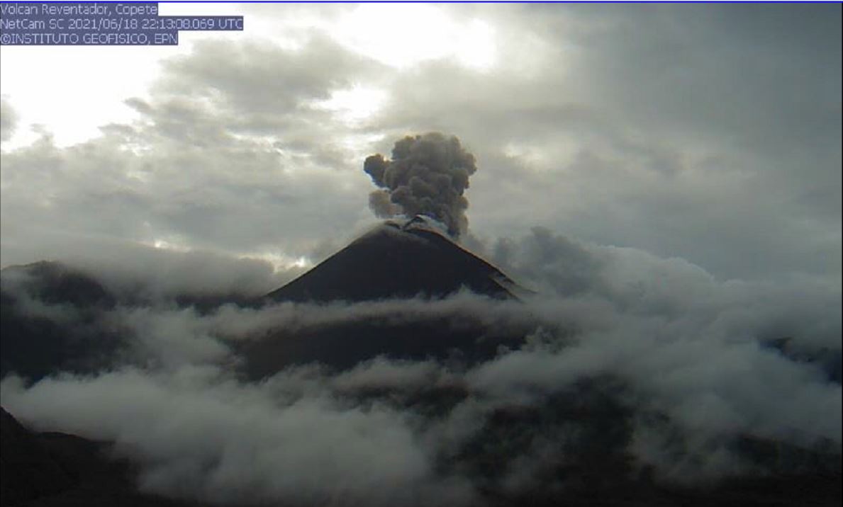
DAILY REPORT OF THE STATE OF THE REVENTADOR VOLCANO, Monday June 21, 2021.
Information Geophysical Institute – EPN.
Surface activity level: High, Surface trend: increasing.
Internal activity level: Moderate, Internal trend: No change.
Seismicity: From June 20, 2021, 11: 00h to June 21, 2021, 11: 00h:
Explosions (EXP): 10 events
Long period type events (LP): 24
Emission tremor (TREMI): 7
Rains / lahars: Light rains were recorded in the volcano region, without generating lahars.
Emission / ash column: No ash emission on satellite images was recorded by the VAAC.
Observations: Most of the time the volcano remained cloudy, however, at night, an incandescence was observed in the upper part. Today in the morning, it cleared for a short time, without recording any surface activity.
Alert level: Orange.
Source et photo : IGEPN


No comment yet, add your voice below!