
June 19 , 2021.
Alaska , Gareloi :
51°47’21 » N 178°47’46 » W,
Summit Elevation 5161 ft (1573 m)
Current Volcano Alert Level: ADVISORY
Current Aviation Color Code: YELLOW
Above background levels of unrest continue at Gareloi volcano. However, the level of seismic activity appears to be declining somewhat. Slightly elevated surface temperatures were observed at the volcano summit several times this week. There have been no other notable changes at the volcano as determined from satellite data and nothing has been detected by local infrasound sensors.

Gareloi volcano persistently emits magmatic gases from a fumarole field on the south crater and commonly exhibits low-level seismic activity. These observations suggest the presence of shallow magma and potential interaction with a hydrothermal system. The current increase in seismicity likely reflects a change to the magmatic-hydrothermal system, but it is not clear that the likelihood of a volcanic eruption has increased. AVO will continue to monitor activity to determine if the recent changes are related to influx of new magma or other changes to the magma system.
Gareloi is monitored by a local seismic and infrasound network, satellite data, and regional infrasound and lightning-detection networks.
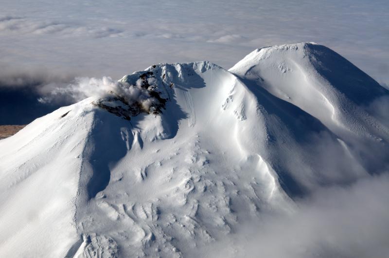
Mount Gareloi, which makes up all of Gareloi Island, is a stratovolcano located in the Delarof Islands group of the Aleutian Islands, about 2,000 km (1,242 mi) west-southwest of Anchorage and about 150 km (93 mi) west of Adak, the westernmost community in Alaska. This small volcano is 10 × 8 km (6.2 × 5.0 mi) in diameter at its base with two summits, separated by a narrow saddle. The northern, slightly higher peak contains crater about 300 m (1,000 ft) across. The southern summit has a crater open to the south and a persistent degassing vent (fumarole) on its western rim. Gareloi has been one of the most active in the Aleutians since the 1740s, with 16 reports of eruptive activity at Gareloi since 1760. In 1929, its largest historical eruption produced sixteen small south- to southeast-trending craters that extend from the southern summit to the coast, as well as lava flows and pyroclastic deposits on the southeastern flank of the volcano. Eruptions of Gareloi commonly produce ash clouds and lava flows, and the primary hazard is airborne clouds of ash that could affect aircraft. Since seismic instruments were installed in 2003, they have detected small but consistent seismic signals from beneath Mount Gareloi’s edifice.
Source : AVO.
Photos : Coombs, M. L. ( 2005) , Read, Cyrus / Alaska Volcano Observatory / U.S. Geological Survey
Italy / Sicily , Etna :
COMMUNICATION ON THE ACTIVITY OF ETNA June 18, 2021, 10:52 (08:52 UTC).
The National Institute of Geophysics and Volcanology, Osservatorio Etneo, reports that from the images of the surveillance cameras, it can be observed that the explosive activity at the Southeast Crater has ceased, the lava overflow extending into the southwest direction is cooling. With regard to the volcanic tremor, the phase of decrease in the average amplitude continued, the values of which are currently fluctuating in the low level.
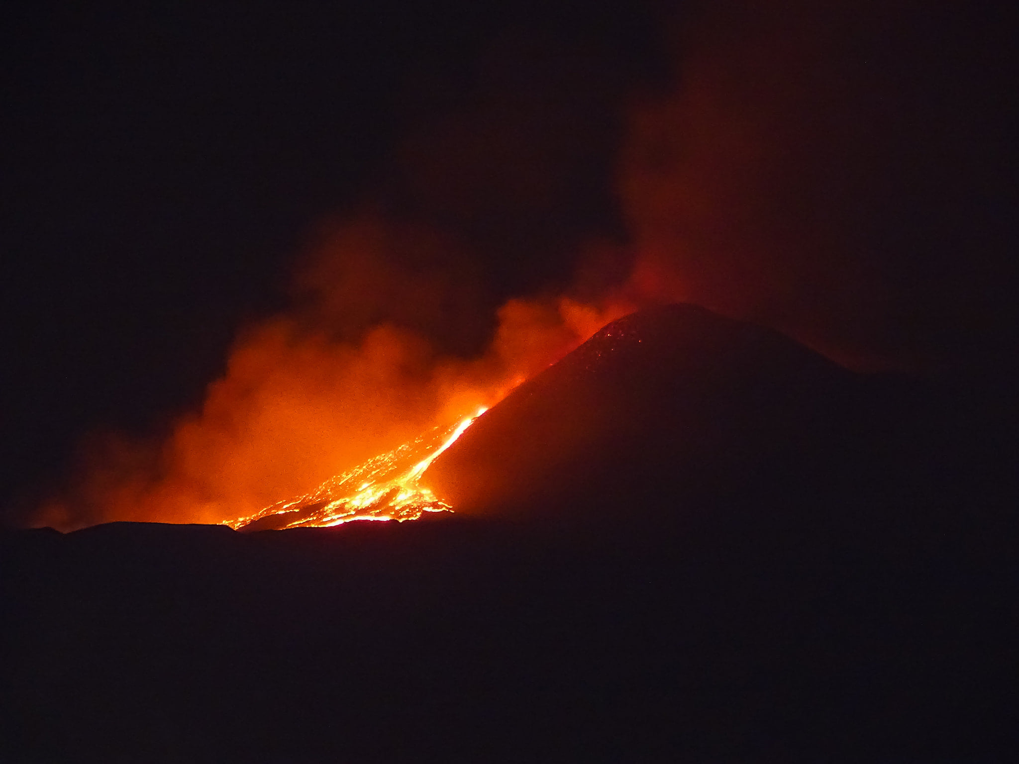
The location of the centroid of the volcanic tremor sources is in the area of the Southeast Crater, at
an altitude of about 2800 m above sea level. The infrasound activity is weak and the few localized events are located in the area of the crater of Bocca Nuova. There are no significant variations in the signals from the GNSS tilt and distortion networks.
Further updates will be communicated shortly.
Source : INGV.
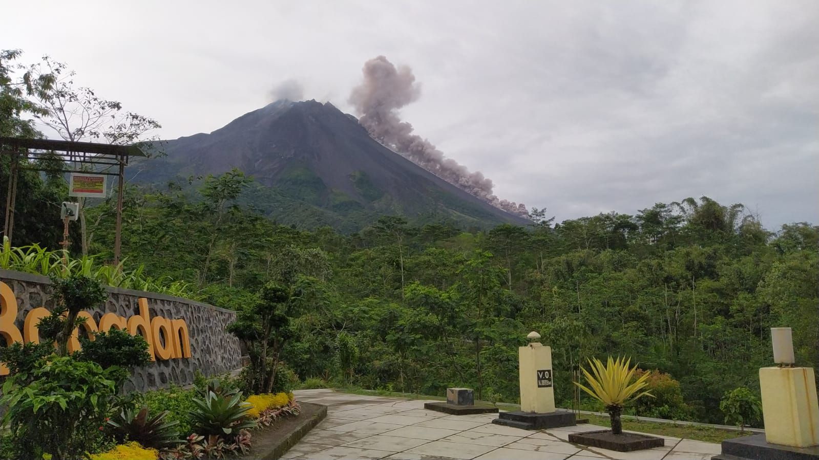
Indonesia , Merapi :
Mount Merapi activity report from June 11 to 17, 2021
OBSERVATION RESULT
Visual
The weather around Mount Merapi is generally sunny in the morning and evening, while it is foggy in the afternoon. There is white smoke, weak to thick with low pressure. The maximum smoke height of 400m was observed from the Mount Merapi observation post in Kaliurang on June 15, 2021 at 7:05 am WIB.
Hot avalanche clouds have occurred 19 times with a maximum slide distance of 2,000 m to the southwest and 1,000 m to the south-east, recorded on a seismogram with a maximum amplitude of 67 mm and lasting 191 seconds. Lava avalanches have been observed 100 times to the southwest with a maximum slide distance of 2000 meters and 8 times to the southeast with a slide distance of 1000 m.
The volume of the lava dome in the southwest sector is 1,390,000 m3 with a growth rate of 11,300 m3 / day. Morphological analysis of the peak area based on photos of the Southeast sector from June 17 to June 8, 2021 shows an increase in the height of the central dome of 1 m
Seismicity
This week, the seismicity of Mount Merapi recorded
19x Hot Cloud Avalanche (AP)
17 shallow volcanic earthquakes (VTB),
136 multi-phase earthquakes (MP),
2 low frequency earthquakes (LF),
1,158 avalanche earthquakes (RF),
108 emission earthquakes (DG)
6 tectonic earthquakes (TT).
The intensity of internal earthquakes such as VTB and MP this week is lower than last week.
Deformation
The deformation of Mount Merapi, which was monitored using EDM this week, showed a distance shortening rate of 0.7 cm / day.
Rain and lahars
This week, it rained at the Mount Merapi observation post with an intensity of 34 mm / hour for 30 minutes at the Ngepos post on June 16, 2021. There were no reports of lahars or additional flow in the mountains. rivers that take their source on Mount Merapi.
Conclusion
Based on the results of visual and instrumental observations, it is concluded that:
The volcanic activity of Mount Merapi is still quite high in the form of effusive eruption activity. The status of the activity is defined in the “SIAGA” level.
Source and photo : BPPTKG.
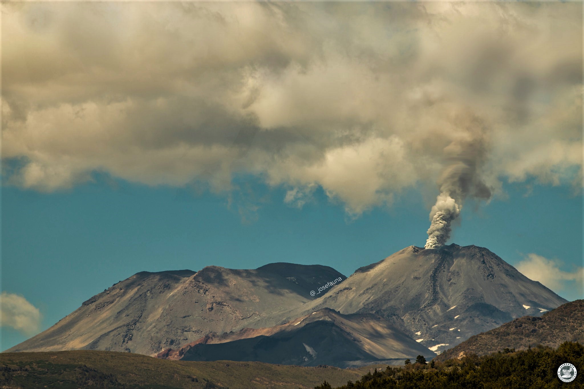
Chile , Nevados de Chillan :
Special Report on Volcanic Activity (REAV), Ñuble region, Nevados de Chillán volcanic complex, June 17, 2021, 02:23 a.m. local time (Continental Chile).
The National Service of Geology and Mines of Chile (Sernageomin) publishes the following PRELIMINARY information, obtained thanks to the monitoring equipment of the National Volcanic Monitoring Network (RNVV), processed and analyzed in the Volcanological Observatory of the Southern Andes ( Ovdas):
On Thursday 17 June, at 02:16 local time (06:16 UTC), the monitoring stations installed near the volcanic complex of Nevados de Chillán recorded an explosion associated with a long period type earthquake, associated with the dynamics of fluids in the system. volcanic.
The characteristics of the earthquake after its analysis are as follows:
ORIGINAL TIME: 02:16 local time (06:16 UTC)
LATITUDE: 36.866 ° S
LONGITUDE: 71.373 ° W
DEPTH: 0.6 km
REDUCED DISPLACEMENT: 507.03 (cm2)
ACOUSTIC SIGNAL: 0.72 Pa reduced to 1 km.
The characteristics associated with surface activity are as follows:
MAXIMUM HEIGHT OF THE COLUMN: 60 m above the point of emission.
DIRECTION OF DISPERSION: Not observed.
Observations:
Permanent explosive activity has been observed during the last few days. .
The volcanic technical alert remains at the Yellow level.
Source : Sernageomin
Photo : Josefauna.
Saint Vincent , Soufrière Saint Vincent :
La Soufriere Volcano – SCIENTIFIC UPDATE June 18, 2021 1:00PM
-Seismic activity at La Soufrière, St Vincent has remained low since the tremor associated with the explosion and ash venting on 22 April and in the last 24 hours, only a few earthquakes have been recorded.
– Persistent steam emissions from a few regions inside the crater continue to be the dominant observable feature.
– Thermal anomalies continue to be detected but do not indicate an explosive event is imminent but that there is a source of heat, most likely from a small body of magma left over, close to the floor of the Summit Crater.
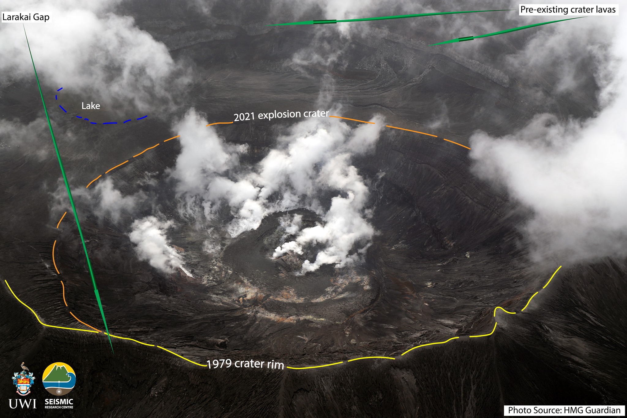
This image taken by the HMG Guardian on 12June shows the new look of the crater of La Soufriere . Professor Robertson has labelled the photo so we can observe the 1979 crater rim, the new 2021 explosion crater rim and the lake.
– Measurement of the sulphur dioxide (SO2) flux was carried out off the west coast on June 15th and yielded an average SO2 flux of 352 tons/day.
– Work is underway to restore capacity lost during the explosive phase of the eruption. This will continue until the end of June.
– The volcano continues to be in a state of unrest. While volcanic activity has been on a decline the continued presence of near surface hot spots, daily seismic activity and substantial degassing is proof that the system is still in unrest and escalation in activity can still take place with little or no warning.
– The volcano is at alert level ORANGE.
Source : UWI.
Photo : HMG Guardian/ Professor Robertson


No comment yet, add your voice below!