
June 15 , 2021.
Iceland , Geldingadalur / Fagradalsfjall :
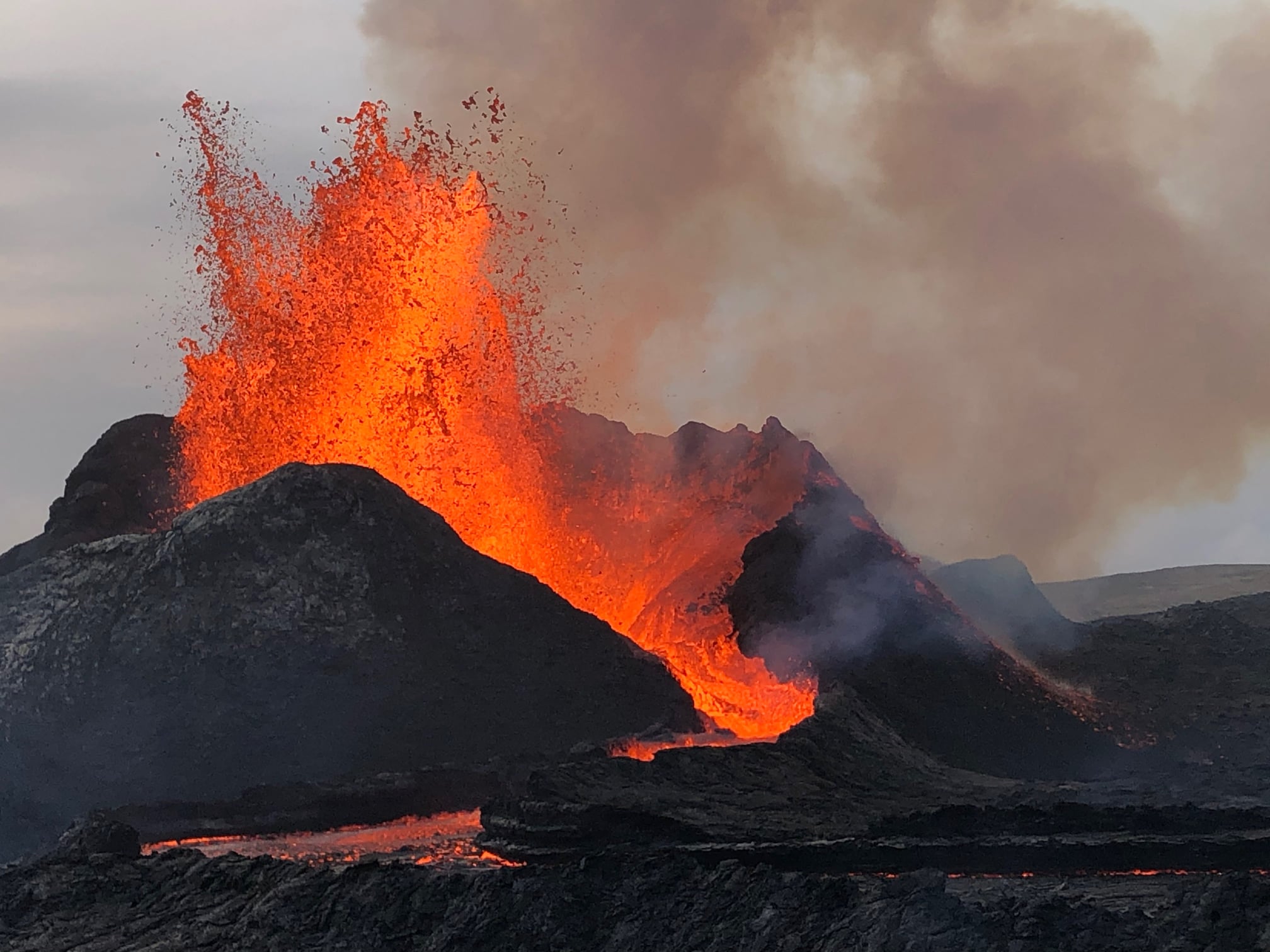
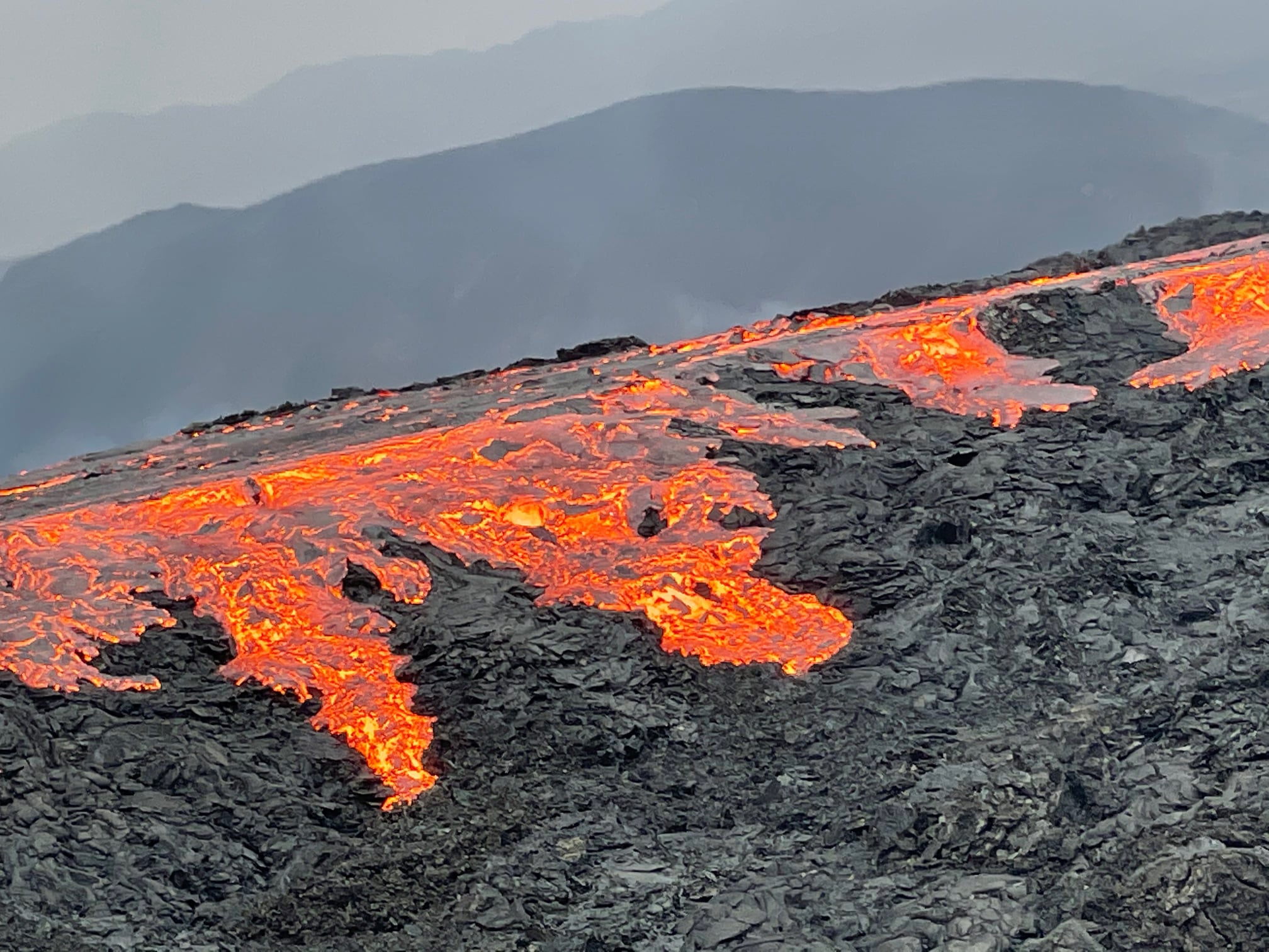
June 13, 2021
Lava flow measurements
Further measurements were taken on Friday, June 11, when the Garfield drone flew with the Natural Resources Institute’s Hasselblad camera and has now prepared new ground models of Fagradalshraun by the images.
The average lava flow over the period June 2-11 (9 days) has a flow rate of just under 12 m3 / s, which is unchanged from the previous period (May 18 to June 2). The lava flow has therefore remained almost stable for the past six weeks and has been twice as large as the average for the first six weeks.
The lava volume now measures 63 million cubic meters and its area is 3.23 square kilometers. The area has increased considerably since the last measurement with more than 60,000 square meters per day. It corresponds to about 9 football stadiums per day.
Lava flow preview (updated June 13)
As mentioned earlier, the rash can be divided into three seasons:
The first period lasted about two weeks and was characterized by a rather stable but slightly decreasing lava flow. The flow went from 7-8 m3 / s to 4-5 m3 / s in two weeks.
The second period, which also lasted two weeks, was characterized by the opening of new fractures north of the original craters. The lava flow varied somewhat, between 5 and 8 m3 / s.
The third period has now lasted for eight weeks. During this period, the activity has been in a single crater from which lava is emitted. It’s okay to divide those eight weeks into two. During the first two weeks, the lava flow had a flow rate of 5 to 8 m3 / s, but during the last six weeks it has been between 11 and 13 m3 / s.
Source : http://jardvis.hi.is/eldgos_i_fagradalsfjalli
Photos : Guy de Saint Cyr / Aventure et volcans.
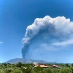
Italy / Sicily , Etna :
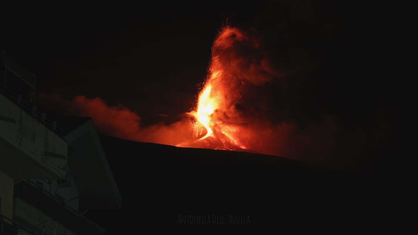
Press release on the activity of ETNA, June 14, 2021, 22:56 (20:56 UTC).
The National Institute of Geophysics and Volcanology, Osservatorio Etneo, announces that from approximately 20:20 UTC, a sudden increase in Strombolian activity is observed at the level of the Southeast Crater, which produces a continuous emission of ash that disperse in the summit region. The products of Strombolian activity exceed the edge of the crater and fall back on its sides.
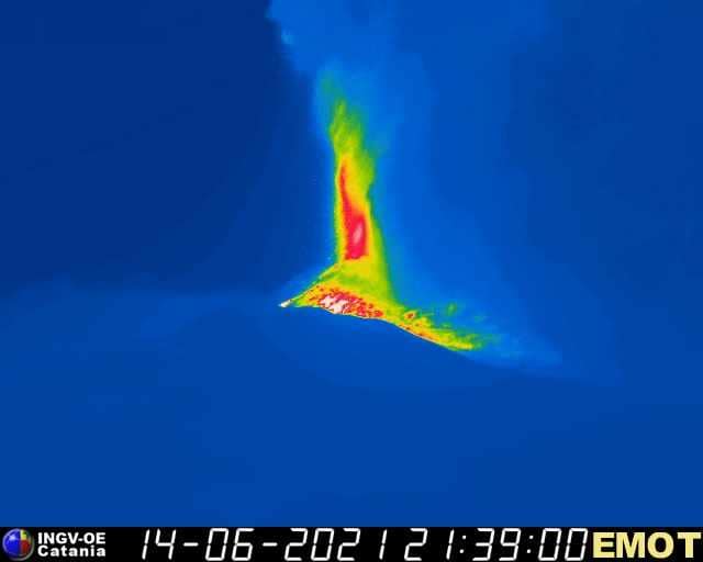
The mean amplitude of the volcanic tremor showed a sudden increase around 8:00 p.m. UTC reaching high levels, where it still stands. The location of the source centroid is in the Southeast Crater area at an altitude of about 2900 m above sea level. Infrasound activity does not show significant changes and remains at low levels .
Since the last update, no significant changes have been observed in the time series of soil deformation monitoring stations.
Press release on the activity of ETNA, June 14, 2021, 23:32 (21:32 UTC).
The National Institute of Geophysics and Volcanology, Osservatorio Etneo, reports that a further increase in Strombolian activity at the Southeast Crater is observed from around 9:10 p.m. UTC from surveillance cameras. Based on the forecast model, the eruptive cloud produced by this activity disperses in a south-easterly direction. In addition, an overflow of lava is observed from the southern flank of the Southeast Crater which extends in a southwest direction.
Simultaneously with the increase in Strombolian activity, a further increase in the average amplitude of the volcanic tremor towards the high level is observed. The location of the center of gravity of the volcanic tremor sources remains in the Southeast Crater area at an altitude of about 2900 m above sea level. Infrasound activity also showed an increase in both the rate of occurrence of events and their magnitude. The events are located in the Southeast Crater area.
Since the last update, no significant changes have been observed in the time series of soil deformation monitoring stations.
At 23:47 (21:47 UTC), Strombolian activity turned into a lava fountain.
The average amplitude of the volcanic tremor and the infrasound activity reached very high values. The sources of tremors and infrasonic events are located in the Southeast Crater.
The highest stations in the inclinometric network register modest signal variations.
Press release on the activity of ETNA, June 15, 2021, 01:20 (23:20 UTC).
The National Institute of Geophysics and Volcanology, Osservatorio Etneo, announces that from the images of the CCTV cameras, it is observed that the lava fountain of the Southeast Crater, reported in the previous press release, has ceased to 22:44 UTC.
Regarding the lava overflow, we observe that the one directed towards the southwest continues to be fed.
As for the average amplitude of the volcanic tremor, after reaching the maximum value at 22:00 UTC, it suffered a rapid decrease returning to the low level, where it still remains. The center of gravity of volcanic tremor sources remains localized in the area of the Southeast Crater at an altitude of about 2800 m above sea level. The infrasound activity has also decreased both in the number of ‘events and in their amplitude, returning to low values.
The stations of the inclinometric network recorded modest variations in correspondence with the activity of the lava fountain which ends around 22:45 UTC. No significant change is observed in the GNSS data.
Further updates will be communicated shortly.
Source : INGV.
Photos : Antonella Dell’Aquila, INGV .
Video : Salvatore Lo Giudice
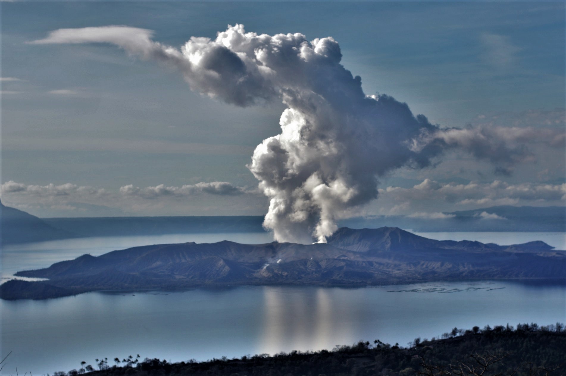
Philippines , Taal :
TAAL VOLCANO BULLETIN 15 June 2021 08:00 A.M.
In the past 24-hour period, the Taal Volcano Network recorded two hundred twenty-one (221) volcanic earthquakes, including twenty-nine (29) low frequency volcanic earthquakes and one hundred ninety-two (192) volcanic tremor events having durations of one (1) to one hundred thirty-five (135) minutes, and low-level background tremor has persisted since 08 April 2021. Activity at the Main Crater was dominated by upwelling of hot volcanic fluids in its lake which generated plumes 1500 meters tall that drifted to the southwest. Sulfur dioxide (SO2) emission averaged 5,837 tonnes/day on 14 June 2021. Based on ground deformation parameters from electronic tilt, continuous GPS and InSAR monitoring, Taal Volcano Island has begun deflating in April 2021 while the Taal region continues to undergo very slow extension since 2020. These parameters indicate overall that magmatic unrest continues to occur at shallow depths beneath the edifice.
Alert Level 2 (Increased Unrest) is currently maintained over Taal Volcano. DOST-PHIVOLCS reminds the public that at Alert Level 2, sudden steam- or gas-driven explosions, volcanic earthquakes, minor ashfall, and lethal accumulations or expulsions of volcanic gas can occur and threaten areas within and around TVI. DOST-PHIVOLCS strongly recommends that entry must be strictly prohibited into Taal Volcano Island, Taal’s Permanent Danger Zone or PDZ, especially the vicinities of the Main Crater and the Daang Kastila fissure, and occupancy and boating on Taal Lake. Local government officials are advised to continuously assess and strengthen the preparedness of previously evacuated barangays around Taal Lake in case of renewed unrest. Civil aviation authorities must advise pilots to avoid flying close to the volcano as airborne ash and ballistic fragments from sudden explosions and wind-remobilized ash may pose hazards to aircraft.
DOST-PHIVOLCS is closely monitoring Taal Volcano’s activity and any new significant development will be immediately communicated to all stakeholders.
Source : Phivolcs.
Photo : Richard Langford.
Peru , Sabancaya :
Analysis period: June 7, 2021 to June 13, 2021, Arequipa, June 14, 2021.
Alert level: ORANGE
The Geophysical Institute of Peru (IGP) reports that the eruptive activity of the Sabancaya volcano remains at moderate levels, that is to say with the recording of an average of 79 daily explosions, with columns of ash and gas up to an altitude of 2.0 km above the summit of the volcano and their consequent dispersion. Therefore, for the following days, no significant change is expected in eruptive activity.
The IGP recorded and analyzed the occurrence of 1,070 earthquakes of volcanic origin, associated with the circulation of magmatic fluids within the Sabancaya volcano. An average of 79 explosions was recorded daily. During this period, Volcano-Tectonic (VT) earthquakes associated with rock fractures were located mainly in the Northeast, East, and Northwest of Sabancaya and presented magnitudes included between M2.0 and M3.5.
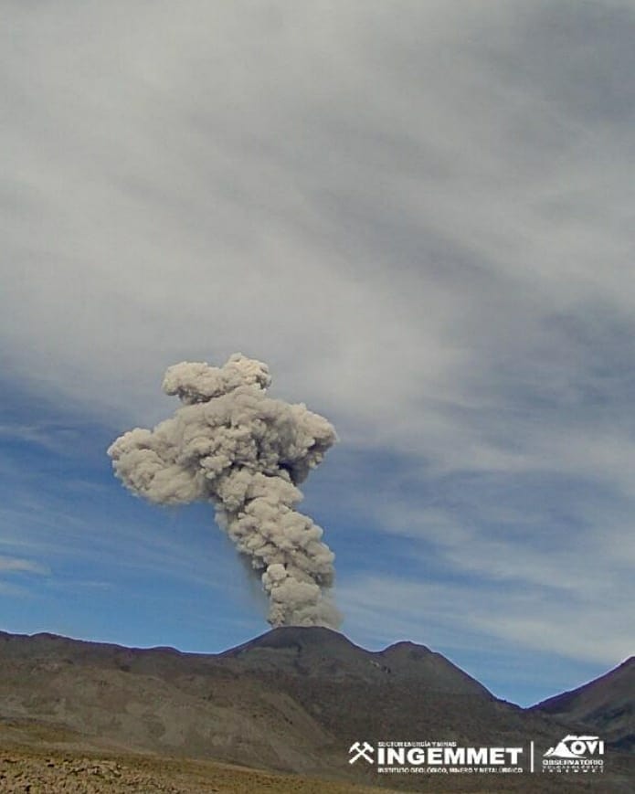
The monitoring of the deformation of the volcanic structure using GNSS techniques (processed with fast orbits) does not show any significant anomalies. However, in general, an inflation process was observed in the northern sector (around the Hualca Hualca volcano). Visual surveillance made it possible to identify columns of gas and ash up to an altitude of 2.0 km above the summit of the volcano, which were scattered towards the South-East, South, East and North-East sectors of the volcano. Sabancaya. Satellite recordings have identified the presence of 11 thermal anomalies (maximum value 22 MW) associated with the presence of a lava body on the surface of the volcano’s crater.
RECOMMENDATIONS
• Keep the volcanic alert level in orange.
• Do not approach within a radius of 12 km from the crater.
Source : IGP.
Photo : Ingemmet .
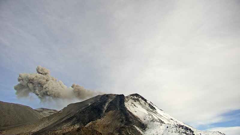
Chile , Nevados de Chillan :
Special Report on Volcanic Activity (REAV), Ñuble region, Nevados de Chillán volcanic complex, June 14, 2021, 1 a.m. local time (Continental Chile).
The National Service of Geology and Mines of Chile (Sernageomin) publishes the following PRELIMINARY information, obtained thanks to the monitoring equipment of the National Volcanic Monitoring Network (RNVV), processed and analyzed in the Volcanological Observatory of the Southern Andes ( Ovdas):
On Monday, June 14, at 00:00 local time (04:00 UTC), the monitoring stations installed near the Nevados de Chillán volcanic complex recorded a series of earthquakes associated with fluid dynamics in the volcanic system (long period type), accompanied by an explosive-type surface activity, which presented a high energy level.
The characteristics of the earthquake after its analysis are as follows:
ORIGINAL TIME: 00:14 – 00:40 local time (04:14 UTC)
LATITUDE: 36.868 ° S
LONGITUDE: 71.369 ° W
DEPTH: 2.2 km
REDUCED DISPLACEMENT: 640 (cm2)
ACOUSTIC SIGNAL: 14.7 Pa reduced to 1 km.
The characteristics associated with surface activity are as follows:
MAXIMUM HEIGHT OF THE COLUMN: 200 m above the point of emission (incandescence).
Observations:
The seismic activity was accompanied by superficial manifestations (incandescence) and dispersion of pyroclastic materials around the zone of the point of emission.
The volcanic technical alert remains at the Yellow level.
Source et photo : Sernageomin .


No comment yet, add your voice below!