
April 18 , 2021 .
La Réunion Island , Piton de la Fournaise :
Press release of April 17, 2021 – 2:30 p.m.
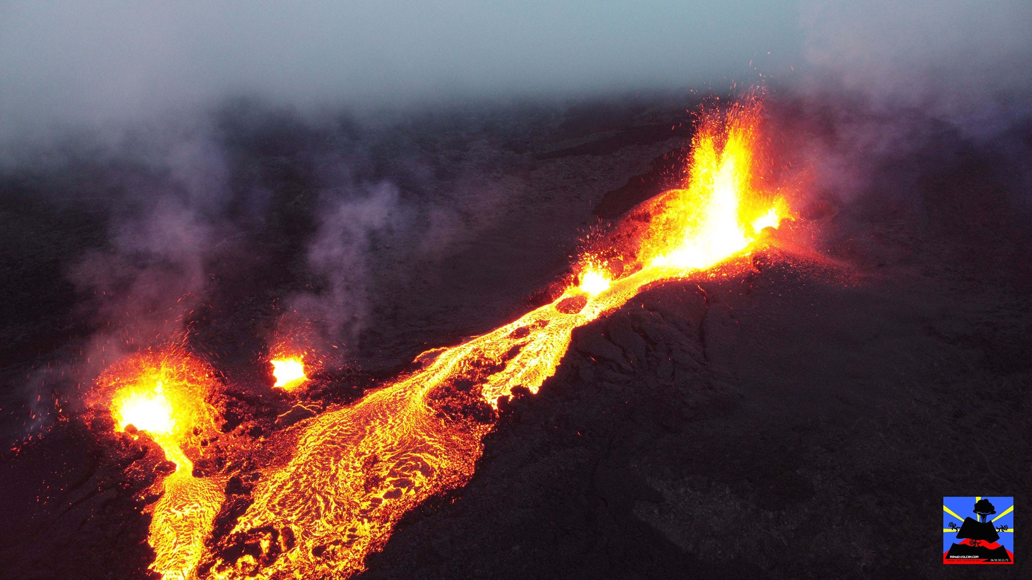
The eruption that started on 04/09/2021 at 7 p.m. (appearance of the tremor) continues. The intensity of the volcanic tremor (indicator of a surface lava emission) over the last 24 hours has remained relatively stable.
– Observations of the eruptive site always show:
. that lava fountain activity continues, mainly on the main cone located most upstream.
. and that the flow activity is focused on the plateau downstream of the eruptive site, with the establishment of a lava tunnel regime showing numerous resurgences.
– Over the last 24 hours, 10 superficial volcano-tectonic earthquakes (between sea level and the surface) have been recorded under the summit craters.
– The summit of the volcano still shows a weak deflation (deflation), of the order of one centimeter, in connection with the emptying of the superficial magmatic reservoir located under the Dolomieu crater at 1.5-2 km depth which currently feeds the eruptive site.
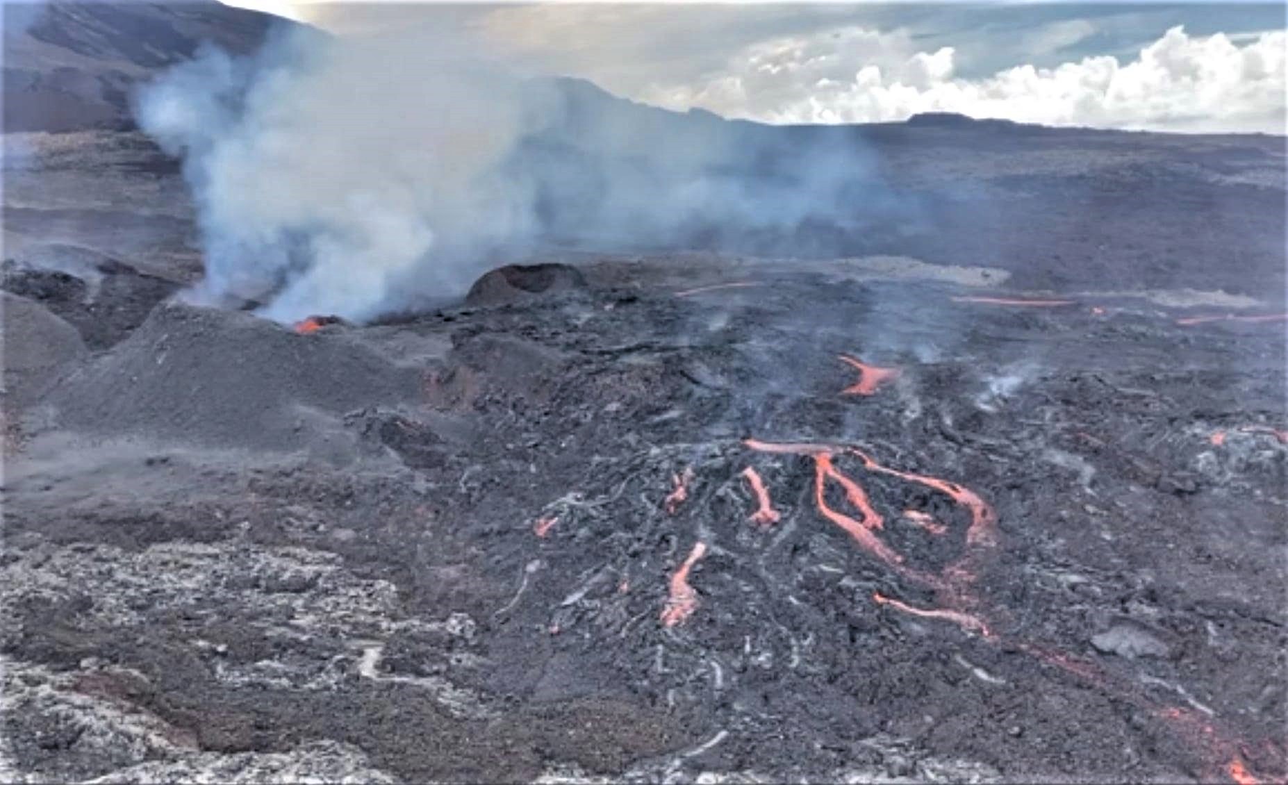
– The average lava flow rates estimated from the SO2 flows measured by the DOAS “NOVAC” network for the day of 04/16 are of the order of 8.3 m3 / sec, ie about 3 times less than the observed flow during the peak of the day of 04/13. It should be noted that bad weather conditions can affect the accuracy of the measurements.
– For comparison, the surface flows estimated from satellite data via the HOTVOLC platform (OPGC – Clermont Auvergne University) recorded values between 3 and
14m3 / sec over the last 24 hours. It should be noted that bad weather conditions can affect the accuracy of the measurements.
Analysis of eruptive products
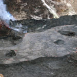
The lava samples taken from the eruptive site on April 11 by teams from the OVPF IPGP could be analyzed at the IPGP in Paris and at the Observatoire de Physique du Globe de Clermont
Ferrand (OPGC-LMV). Pyroclastic samples emitted by the lava fountains had been sampled near the main cone, and the lavas had been sampled downstream of the
eruptive fracture.
The pyroclastic deposits of the lava fountains consist entirely of « golden » type pumice. This variety of pumice is characterized by millimeter vesicles organized around
large central centimetric vesicles. Their vesicularity reaches very high values up to 86% vol% with 10 to 20% of isolated vesicles (not connected to each other).
Mineralogical analysis indicates the presence, in decreasing order of plagioclase, pyroxene and olivine.
The proportion of olivine is lower in the flows and greater in the projections.
The abundance of plagioclase and pyroxene reflects relatively low temperatures overall and an overall evolved nature of the magmas emitted.
Lavas are rich in microcrystals (44%) while pyroclastic products are much more vitreous (a few percent of microcrystals). Electronic imaging confirms very high proportions of plagioclase and clinopyroxene compared to olivine, especially in lavas. Millimeter crystals (phenocrysts) are rare and observed for the moment only in the lava.
The results show that the lavas emitted during the first part of the activity which began on April 9 have a high density and degree of crystallization and have a fairly high chemical composition.
differentiated. Analysis of the projections indicates a magma temperature at the vent of about 1155 ° C.
The chemical analysis and the physical properties suggest that the first magma emitted corresponds to the cooling, degassing and differentiation of the more primitive and hotter magmas set up at the beginning of the year 2020. This “old” magma could be pressurized and expelled by the rise of new, deeper and hotter magma that had not yet reached the surface until 04/11. A more detailed report on these analyzes will be attached to the monthly OVPF-IPGP bulletin.
Source : OVPF.
Read the article : https://www.ipgp.fr/sites/default/files/ovpf_20210417_14h30_communique_eruption.pdf
Photos : Vincent Tunneldelave Réunion , OVPF .
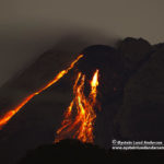
Indonesia , Merapi :
Mount Merapi Activity Report, April 9-15, 2021
I. OBSERVATION RESULTS
Visual
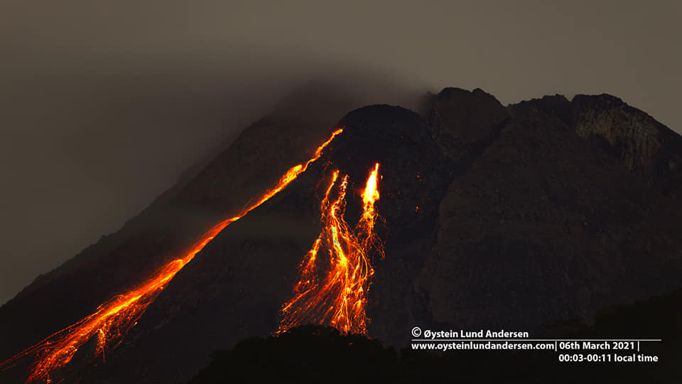
The weather around Mount Merapi is generally sunny in the morning and at night, while the afternoon until evening is foggy. There is white smoke, thin to thick with low pressure. A maximum smoke height of 450 m was observed from the Babadan observation post on April 14, 2021 at 05:30 WIB.
Hot cloud avalanches occurred 6 times with an observed sliding distance of 1800 m towards the southwest and recorded on a seismogram with a maximum amplitude of 46 mm and a duration of 132 seconds. Lava avalanches have been observed 119 times with a maximum slide distance of 1500 meters to the southwest and 7 times to the southeast with a slide distance of 400 m.
Morphological analysis of the peak area based on photos of the southwest sector from April 15 to April 7, 2021 shows a change in the morphology of the peak area due to effusion activity and the growth of the dome. The volume of the lava dome in the southwest sector is 1,024,800 m3 with a growth rate of 12,200 m3 / day. Morphological analysis of the summit area based on the photo of the Southeast sector from April 14 to April 8, 2021 shows a central dome volume of 1,681,000 m3.
Seismicity
This week, the seismicity of Mount Merapi recorded:
6 hot cloud avalanche (AP),
21 multi-phase earthquakes (MP),
1,038 avalanche earthquakes (RF),
13 emissions earthquakes (DG)
10 tectonic earthquakes (TT).
The intensity of the seismicity this week is relatively constant compared to last week.
Deformation
The deformation of Mount Merapi which was monitored using EDM and GPS this week showed no significant changes.
Rain and lahars
This week, there was rain at Mount Merapi Observation Post with the highest rainfall intensity of 188mm / hour for 55 minutes at Kaliurang Post on April 13, 2021 causing an increase in flow and lahars in the Boyong River.
Conclusion
Based on the results of visual and instrumental observations, it is concluded that:
1. The volcanic activity of Mount Merapi is still quite high in the form of effusive eruption activity. The activity status is defined at the « SIAGA » level.
Source : BPPTKG.
Photo : Oystein Lund Andersen.
Saint Vincent , Soufrière Saint Vincent :
La Soufrière, St. Vincent SCIENTIFIC UPDATE – 17/04/21 6:00AM
– The swarm of long-period and hybrid earthquakes continued at La Soufrière.
– The rate of occurrence of these earthquakes dropped significantly at about 8 pm on 16 April and has remained near-constant since. No episodes of tremor have been recorded in the last 12 hours
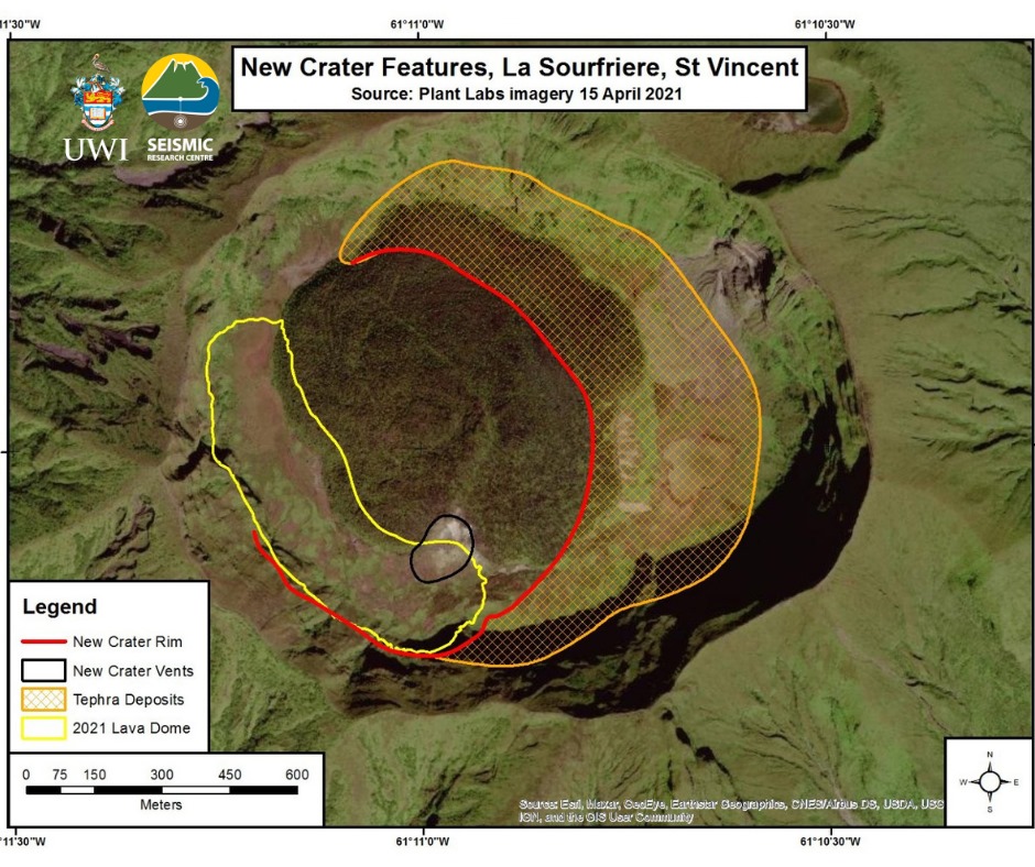
– A revised picture (see figure above) has been constructed of the summit crater based on satellite images.
– The new crater, measures approximately 900 m N to S and at least 750 m E to W.
– The crater is thought to be at least 100 m deep (Raphael Grandin, IPGP) and is centred in the SW sector of the Summit Crater.
– Within the new crater, there are several vents, but only one can be identified clearly. Other vents, as indicated by the ash and steam plumes are located in the northern part of the new crater.
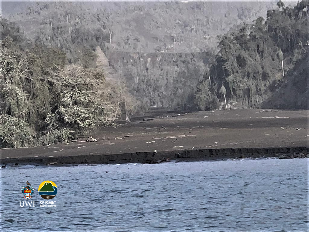
– The volcano continues to erupt although explosive activity appears to have ended at this time.
– Its current pattern of seismic activity may indicate growth of a lava dome, but this has not yet been confirmed.
– Explosions with accompanying ashfall, of similar or larger magnitude, could restart in the future impacting St. Vincent and neighbouring islands.
– The volcano is at alert level Red.
Source et photos : UWI.
Chile , Laguna del Maule :
Special Report on Volcanic Activity (REAV), Maule Region, Laguna del Maule Volcanic Complex, April 15, 2021, 06:25 local time (Continental Chile)
The National Service of Geology and Mines of Chile (Sernageomin) publishes the following PRELIMINARY information, obtained thanks to the monitoring equipment of the National Volcanic Monitoring Network (RNVV), processed and analyzed in the Volcanological Observatory of the Southern Andes ( Ovdas):
On Thursday April 15 at 05:09 local time (09:09 UTC), monitoring stations installed near the Laguna del Maule volcanic complex recorded an earthquake associated with both rock fracturing and fluid dynamics. inside the volcanic system (Hybrid type).

The characteristics of the earthquake after its analysis are as follows:
ORIGINAL TIME: 05:09 local time (09:09 UTC)
LATITUDE: 36.198 ° S
LONGITUDE: 70.484 ° W
DEPTH: 7.6 km
LOCAL MAGNITUDE (ML): 3.0
REDUCED DISPLACEMENT (DR): 1703 cm2
OBSERVATIONS:
Before and after the reported earthquake, events with similar characteristics and lower energy were recorded.
From the available images, no anomalies associated with the described event were observed.
The volcanic technical alert remains at the Yellow level.
Source : Sernageomin.
Photo : Dr Katie Keranen.
Indonesia , Ili Lewotolok :
Level of activity at level III (SIAGA) since November 29, 2020 at 1:00 p.m. WITA. This increase in status was motivated by an eruption on November 27, 2020 at 05:57 a.m. WITA with an ash column height observed gray to black, 500 m above the summit (1923 m asl) with a strong intensity, oriented towards the west. This eruption was recorded on a seismogram with a maximum amplitude of 34 mm and the duration of the eruption was not clearly observed because it had been followed by continuous tremors. The eruption still occurs today.
The volcano is clearly visible until it is covered in fog. The smoke from the crater is white / gray with low to high intensity, about 50-1300m above sea level from the top of the crater. The weather is sunny to rainy, the wind blows weakly to the east and west. There was an eruption accompanied by moderate rumbling.
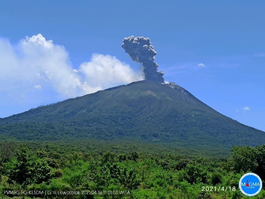
There was an eruption on Mount Ili Lewotolok, Nusa Tenggara East on April 18, 2021 at 11:01 a.m. WITA with an observed height of the ash column of ± 1,500 m above the summit (± 2,923 m above the summit. sea level). We observe that the ash column is gray / black with a strong intensity, inclined towards the South and the South-West. This eruption was recorded on a seismogram with a maximum amplitude of 8 mm and a duration of ± 52 seconds.
According to the seismographs of April 17, 2021, it was recorded:
1 eruption / explosion earthquake
2 emission earthquakes
1 harmonic earthquake
Continuous tremor with an amplitude of 0.5 mm (dominant value 0.5 mm).
Source : PVMBG.
Photo : Magma Indonésie.


No comment yet, add your voice below!