
March 18 , 2021.
Ecuador , Sangay :
SANGAY VOLCANO SPECIAL REPORT NO. 2021-001
Volcanic activity from March 5 to 6 and 11.
SEISMIC RECORDING
To monitor the Sangay, the IG-EPN transmits and analyzes data from local and regional seismic and acoustic sensors in real time. However, the local network currently consists of a single seismic-acoustic monitoring point, called SAGA and located about 6 km from the summit. In addition, the PUYO and TAIS stations are used, located 60 and 40 km from the summit, and which, after specific processing, make it possible to record the seismic signals of the events. Prior to the March 5 eruption, SAGA was functioning properly and based on this data, a maximum of 6 medium-sized explosions were recorded in the 18 hours prior to the start of the eruption. This number is relatively low, but not unusual for this volcano given its continued activity.
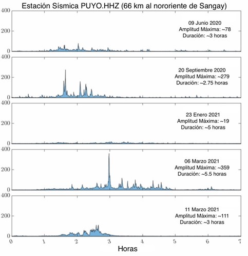
Comparison of the seismic amplitudes and the duration of the 5 activity peaks of Sangay recorded since May 2019. All these eruptions are VEI 2 except that of January 23 which is a VEI 1. VEI represents the volcanic explosive index and is l scale which is used to measure the size of eruptions.
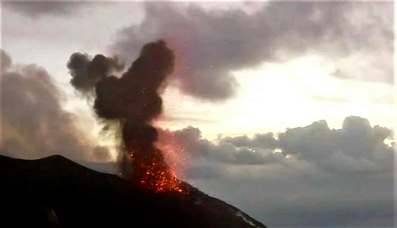
Eruption of March 5
As of 9:45 p.m. local time on March 5, SAGA and other regional seismic sensors began recording intense seismic tremor associated with sustained ash emission. This signal was characterized by low frequency and was clearly visible at regional stations. By comparing the seismic records, it was established that this episode could be similar to the one that occurred on January 23. However, the tremor was prolonged in time and pulses of greater amplitude were observed after two hours, exceeding what had been observed during the previous eruption. At 11:50 p.m., the highest peak in the amplitude of the seismic signal was recorded and 30 minutes later, the increase in the size of the volcanic cloud could be observed on the satellite images. This eruption lasted for 3 hours before finally returning to the lower levels. As the SAGA data ceased to be transmitted after 2:43 am, it was necessary to resort to seismic surveys from regional stations to confirm the end of this peak of activity.
March 11 eruption
In the days following the eruption of March 5, the volcano returned to its previous state of internal activity, characterized by sequences of explosions interspersed with hours or days of calm. During all this time, SAGA has stopped working, probably because of the fall of ash on the solar panels which prevents the charging of the batteries which feed the station. In the early hours of March 11, a new episode of emission tremor was identified in regional sensors filtered to highlight activity from Sangay. With these data, the appearance of a new eruptive impulse could be confirmed.
CLOUDS AND ASH FALLS
During the eruption of March 05-06, the appearance of an ash cloud could be observed on the GOES-16 satellite which grew from 22:00 TL until reaching its maximum height of more than 7 km above. above the crater level just after midnight. The direction of the ash cloud was west and southwest at a speed of 5 m / s. From 03:00 TL on March 6, the height of the ash emission decreased to 2 km above crater level, directed west and southwest, and continued for several hours. The eruptive cloud caused moderate to heavy ash fall in the provinces of Chimborazo and Bolívar, but also reached the provinces of Cañar, Los Ríos and Guayas where it forced the temporary closure of Guayaquil airport on March 6.
At the start of the eruption of March 11, the Sangay volcano was already emitting ash and on the GOES-16 satellite an eruptive cloud with a height of 1.4 km above the level of the crater could be observed directed towards the North West . The increase in the height of the eruptive column was observed from 4:10 TL, reaching about 8.5 km above the crater level. The predominant wind direction during this eruption was west and northwest with a speed of 10 m / s, causing moderate ash fall in the province of Chimborazo, including the town of Riobamba, and light at Bolívar and Morona Santiago. After the eruption, the height of the ash emissions decreased rapidly.
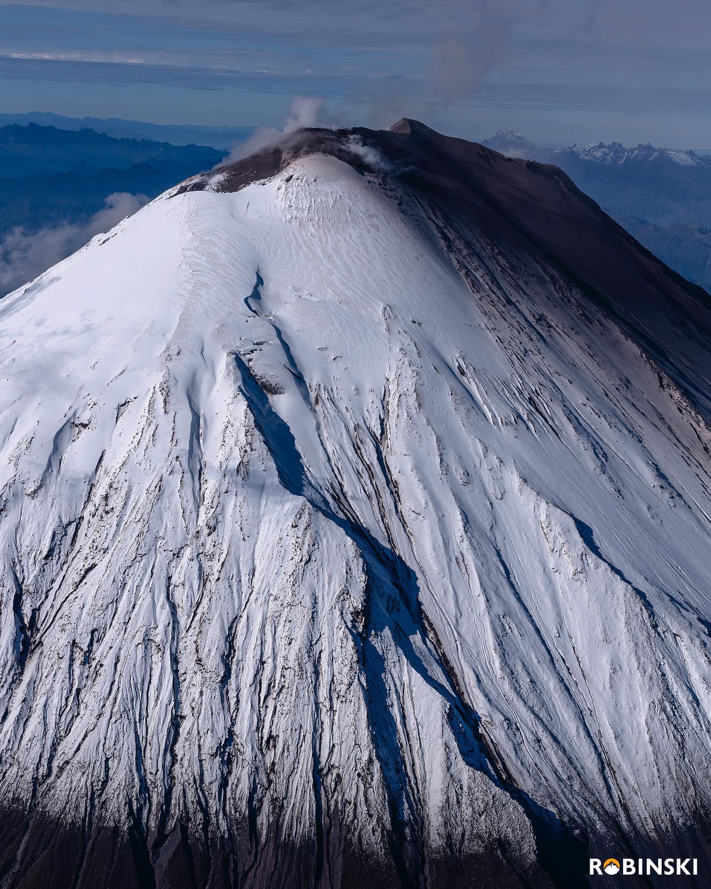
MORPHOLOGICAL CHANGES IN THE SOUTHEAST OF THE SANGAY VOLCANO
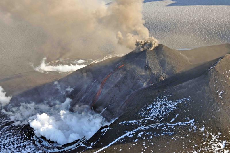
During the current eruptive period of the Sangay volcano, morphological changes have been evident. The main change is related to the erosion on the south-eastern flank, which has led to the formation of a wide ravine through which lava flows and pyroclastic flows (currents of pyroclastic density) are channeled, associated with the collapse of the fronts of the lava flows. During the last overflight in June 2020, the maximum width of this ravine could be measured at around 390 ± 10 meters.
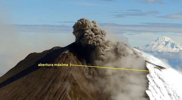
Photograph taken during the flyby on June 24, 2020. In yellow, you can see the southeast ravine and its maximum opening at the top. In addition, a small explosion can be observed, very characteristic of the continuous activity of the volcano since May 2019.
Thanks to the processing of the amplitude images (satellite images which measure the reflection of the satellite beam on the surface), new quantifications of the maximum opening of the south-eastern flank have been carried out. X-band processing (3.6cm wavelength, Terrasar) was used to observe the changes between dates September 12-23, 2020 and compare them with images taken between February 24 and March 7, 2021 As a result, by September 2020 this value had increased, with a maximum aperture of around 500 ± 20 meters, and finally between February and March 2021, this value could be quantified at around 600 ± 40 meters. These values therefore show an increase of at least 100 ± 50 meters every 3 to 5 months. Of course, the rate of erosion will depend on the activity levels of the volcano (e.g., lava flows, pyroclastic flows, explosions), as well as other external erosive agents (e.g., rain, wind, and rain). action of gravity itself). Finally, this erosion will continue until it returns to its level of stability, that is to say when the materials return to their point of equilibrium.
Source : IGEPN
Photos : IGEPN, robinski via marina Morozova.
Italy , Stromboli :
Weekly bulletin, from March 08, 2021 to March 14, 2021. (issue date March 16, 2021)
SUMMARY OF THE STATE OF ACTIVITY
In the light of surveillance data, it is highlighted:
1) VOLCANOLOGICAL OBSERVATIONS: Normal explosive volcanic activity of strombolian type. The total frequency of events showed values ranging from low levels (4 events / h) to medium-low levels (10 events / h). The intensity of the explosions was mainly low in the North crater area and medium-high in the Center-South area.
2) SEISMOLOGY: The monitored seismological parameters do not show significant variations.
3) DEFORMATIONS: The soil deformation monitoring networks did not show significant variations over the period studied.
4) GEOCHEMISTRY: The flow of SO2 is at a medium-low level
C / S ratio: the values are at high levels (C / S = 15.81 measurements on 03/15/2021).
Isotope ratio of He: the values of the last sample (03/09/2021) are fixed at high values (R / Ra = 4.38).
5) SATELLITE OBSERVATIONS: The thermal activity in the summit area is at a low level.
In the period under observation, the eruptive activity of Stromboli was characterized by the analysis of the images recorded by the surveillance cameras INGV-OE located at an altitude of 190 m, Punta Corvi and an altitude of 400 m. Due to unfavorable weather conditions, on March 10, the visibility of the crater terrace was insufficient for a correct description of the eruptive activity.
In the area of the North crater, the N1 crater, with three emission points, produced low intensity explosions (less than 80 m high) emitting coarse materials (lapilli and bombs). The N2 mouth, with two emission points, showed mainly low intensity explosive activity emitting coarse material mixed with ash. The average frequency of explosions varied from 2 to 7 events / h.
In the Center-South zone, the explosions emitted coarse materials mixed with ash, with medium and sometimes high intensity (the products exceeded 250 m in height). The explosive activity showed average hourly frequency values ranging from 1 to 5 events / h.
Source : INGV.
Photo : Webcam .
Alaska , Veniaminof :
56°11’52 » N 159°23’35 » W,
Summit Elevation 8225 ft (2507 m)
Current Volcano Alert Level: WATCH
Current Aviation Color Code: ORANGE
Low-level eruptive activity likely continues at Veniaminof.
Elevated surface temperatures were observed at Veniaminof in satellite images from last night. and a plume containing volcanic gasses continues to be observed in satellite data. Low-level tremor continules to be observed in local seismic data. Minor low-level ash emissions from the small cone within the summit caldera and the eruption of lava within the intracaldera glacier at a vent ~1 km (0.6 miles) east of the cone summit likely continue.
Eruptive activity at Veniaminof usually consists of minor ash emissions, lava fountaining and lava flows from the small cone in the summit caldera. Ash emissions are typically confined to the summit crater, but larger events can result in ash fall in nearby communities and drifting airborne ash.
The partial restoration of local seismic data will help the Alaska Volcano Observatory to detect changes in unrest that may lead to a more significant explosive eruption. AVO combines seismic, infrasound, lightning, web camera, and satellite data for rapid detection of such events.
Source : AVO .
Photo : McGimsey, R. G.
Philippines , Bulusan / Taal :
Bulusan volcano :
BULUSAN VOLCANO ADVISORY: 18 March 2021 12:00 P.M.
This is a notice of an increase in activity of Bulusan Volcano. A total of twenty (20) volcanic earthquakes which includes one (1) tornillo and three (3) low frequency events (LFVQs) were recorded within the last 30 hours by the Bulusan Volcano Network or BVN. Electronic tilt recorded a steady inflation of the upper slopes of the edifice that began on 6 March 2021.
Ground deformation data from continuous GPS measurements indicate a short-term slight inflation since February 2021 while the long-term trend from July 2020 denotes that the edifice is still deflated. Only very weak to weak emission of white steam-laden plumes could be observed at the southeast vents presently. The increased seismic activity and short-term ground deformation are likely caused by shallow hydrothermal processes beneath the edifice.
Alert Level 0 (Normal) is maintained over Bulusan Volcano but is subject to change should current activity persist.
Taal volcano :
TAAL VOLCANO BULLETIN 18 March 2021 08:00 A.M.
In the past 24-hour period, the Taal Volcano Network recorded one hundred and sixty-four (164) volcanic earthquakes, including sixty-seven (67) episodes of volcanic tremor having durations of one (1) to two (2) minutes and three (3) hybrid events. Activity at the Main Crater consisted of weak emission of steam-laden plumes from fumarolic vents that rose 20 meters high.
Sulfur dioxide (SO2) emission that averaged 605 tonnes/day was measured yesterday, 17 March 2021. Temperature highs of 71.8°C and pH of 1.59 were last measured from the Main Crater Lake respectively on 04 March and 12 February 2021. Ground deformation parameters from electronic tilt, continuous GPS and InSAR data analysis indicated a very slow and steady inflation and expansion of the Taal region since after the January 2020 eruption. These parameters may indicate increased magmatic activity at shallow depths beneath the edifice.
Alert Level 2 (Increased Unrest) is maintained over Taal Volcano.
Source : Phivolcs .
Photos : Phivolcs , Julien Monteillet .
Guatemala , Pacaya :
SPECIAL VOLCANOLOGICAL BULLETIN, March 17, 2021 at 11:17 a.m. local time
UPDATE ON ERUPTIVE ACTIVITY
As has been reported in special bulletins, the Pacaya volcano maintains pulses of magmatic activity, which are observed in the Mackenney crater, generating explosions with thick columns of ash, at heights of 3,000 to 3,500 meters. altitude (9842 to 11482 feet). These move southwest, west, northwest, and north at a distance of about 25 to 30 kilometers. Ash falls are reported in the villages of El Rodeo, Patrocinio, El Cedro, San Francisco de Sales, Amatitlán, Villa Nueva with probabilities of ash fall in the capital.
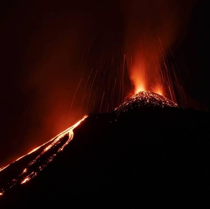
It also ejects ballistic projections 500 meters above the crater, these fall at distances of 300 to 600 meters. On the southern flank, the lava flow with a length of 1,500 meters forms promontories in its lower part and causes fires in the vegetation during its movements. According to reports from OVPAC observers, CONRED web cameras, GOES-16 satellite imagery, activity in the crater between periods of low and high intensity, generates airplane turbine sounds and rumblings. weak and moderate, audible in villages near the volcanic building.
The register of the seismic stations of PCG, and PCG5, shows the increment pulses in the last hours, which favors the formation of thick ash columns.
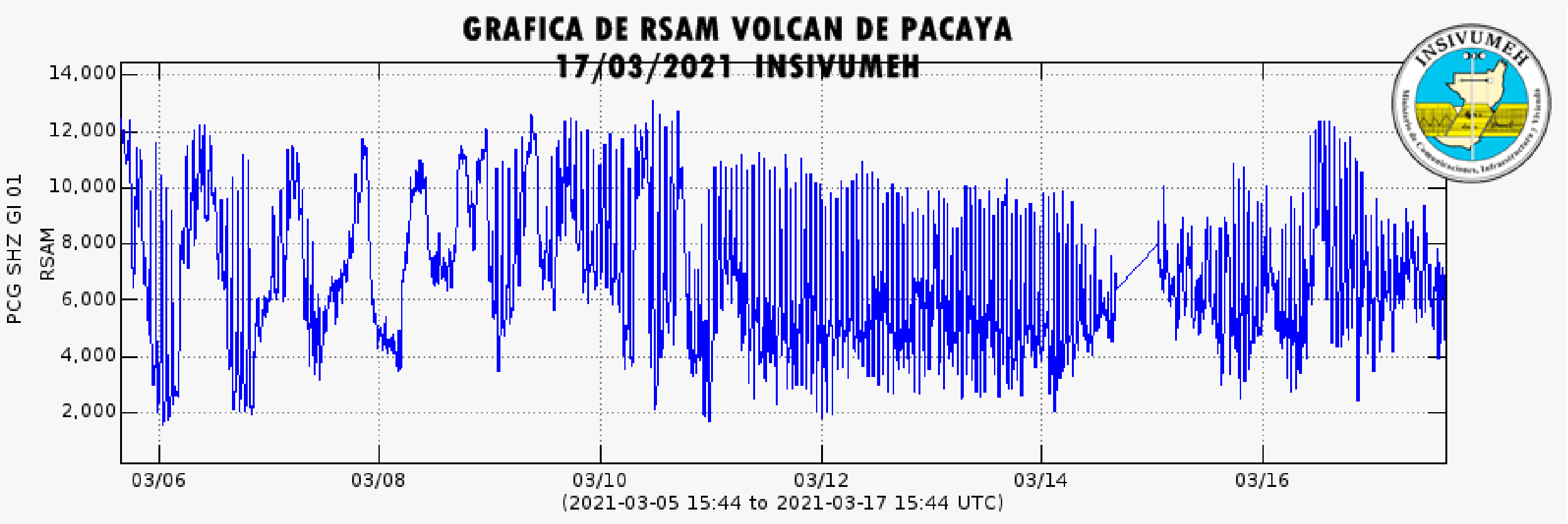
Taking into account the behavioral model that the Pacaya volcano has shown in recent weeks, it is considered that the activity continues at high levels and it is not excluded that increasing impulses will continue to appear in the coming hours, generating explosions, ballistic projections and ash falls, and / or the appearance of new lava flows or the increase in their length.
Source : Insivumeh
Photo : Diegorizzophoto


No comment yet, add your voice below!