
March 06 , 2021 .
Iceland , Reykjanes Peninsula :
A tremor pulse was detected on March 3th at 14:20 which lasted for a few hours and was detected by most seismic stations in Iceland.
An intense earthquake swarm started on the Reykjanes Peninsula on February 24th with an earthquake M5.7 and M5.0. Since then two earthquakes over M5.0 have been detected. They occurred on Feb. 27th and March 1st. Over 22 000 earthquakes have been detected in the area since the activity started. On the 4th of March an M4.2 earthquake was detected 2 km N of Grindavík. It was felt.
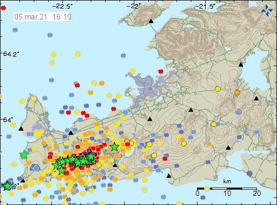
Yesterday around 2800 earthquakes were detected and from mid-night around 700 have been detected. No tremor has been measured during the night, but the earthquake activity is still much.
At 04:11 (today) an earthquake of M3.7 occurred by Fagradalsfjall. Five other earthquakes were measured above M3 tonight. At 23:29 (5th of march) an earthquake of M3,5 was located by Fagradalsfjall. There were 3 earthquakes larger than M3 detected at noon, they were felt.
Source : vedur is
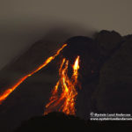
Italy / Sicily , Etna :
Communication on ETNA’s activity, 05 March 2021, 10:08 (09:08 UTC).
The National Institute of Geophysics and Volcanology, Osservatorio Etneo, reports that from 08:20 UTC there is a slight but constant increase in tremor, the amplitude of which corresponds to the average values. The locations are close to the Southeast Crater.
The infrasound events are few and low energy, located in correspondence with the crater of Bocca Nuova.
Due to the cloud cover, it is not possible to make visual and thermal observations or by personnel present on the ground.
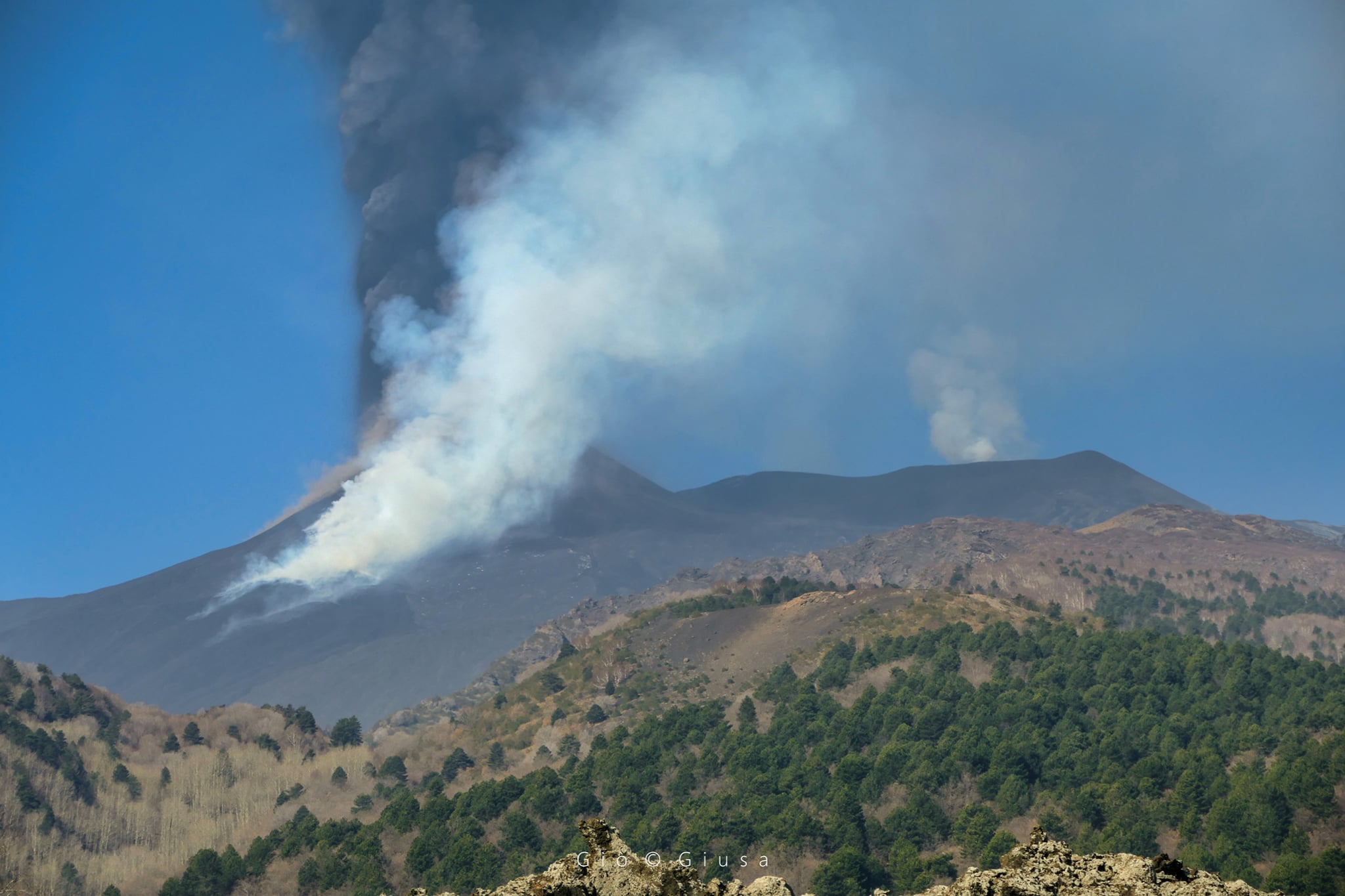
Communication on ETNA’s activity, 05 March 2021, 17:32 (16:32 UTC).
The National Institute of Geophysics and Volcanology, Osservatorio Etneo, announces that during the last hours, the average amplitude of the volcanic tremor has remained in the medium-low range and the relative locations are located in correspondence with the craters of the Bocca Nuova and Voragine. The number and amplitude of infrasonic events are low and the locations are close to the Bocca Nuova crater.
Source : INGV.
Photo : Gio Giusa
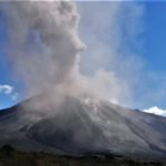
Guatemala , Pacaya :
SPECIAL VOLCANOLOGICAL BULLETIN, March 5, 2021, 11:26 a.m. local time.
INCREASE IN ACTIVITY
As indicated in previous special bulletins, the Pacaya volcano exhibits a high level of activity, in the last hours a new impulse of increasing the amplitude of seismic signals has been recorded, which results in constant explosions which launch incandescent materials up to 500 meters above the crater, with an eruptive column of 3500 m altitude (11,483 feet), constant sounds similar to an airplane turbine. We note the emergence of two lava flows, with three active flows in total on the southern flank, 25 meters, 1200 meters and 400 meters respectively.
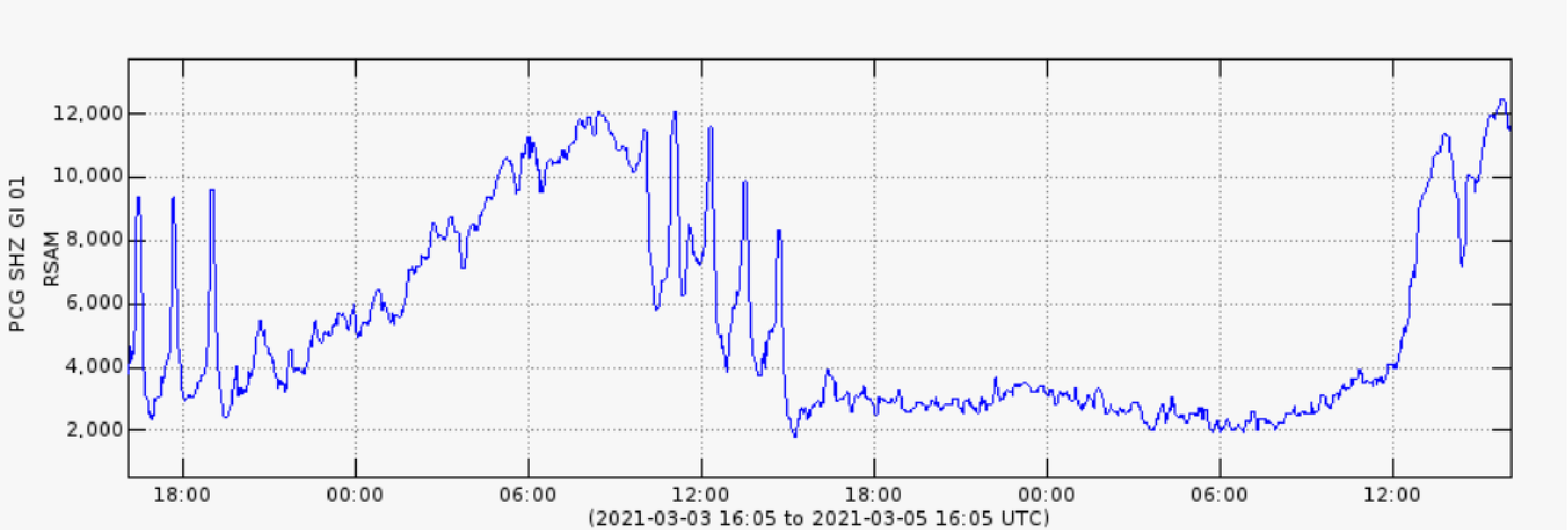
Fig. No. 1: RSAM (Mean Seismic Amplitude) of the PCG station.
The dispersion of ashes is done in a southwest direction, so there is a probability of ash fall in communities located in this direction. There are reports of ash fall in El Patrocinio with probabilities also in the village of El Rodeo.
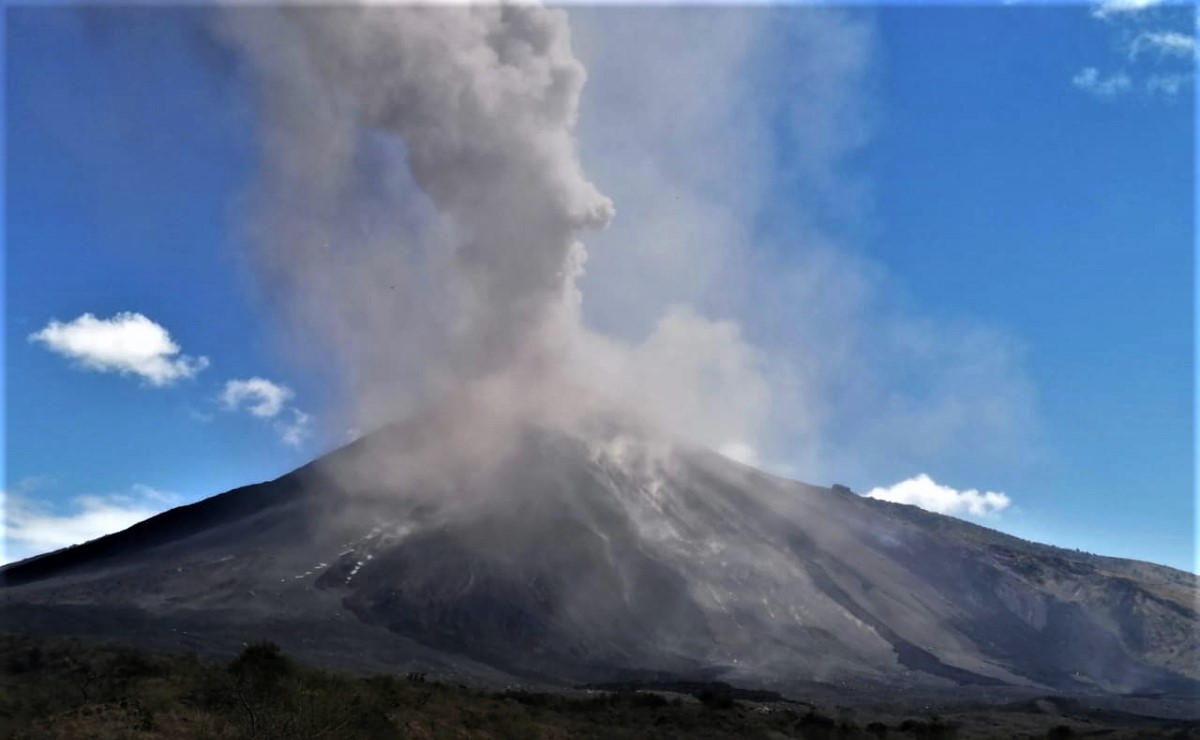
06/03: The eruption continues.
The Strombolian-type eruption of the Pacaya volcano continues, the dense column of ash and gas persists at a height between 4500 and 5550 meters above sea level (14,764 to 18,000 feet) which moves in a West, South-West direction and South. Strong explosions ejecting incandescent materials continue regularly at an altitude of 500 to 700 meters above the crater. Coarse ash falls are reported in areas near Cerro Chino, El Patrocinio and El Rodeo. Ballistic projections (tephra, lapilli from 2 mm to 6 cm or blocks of more than 6 cm) could be released in the area indicated on the attached map.
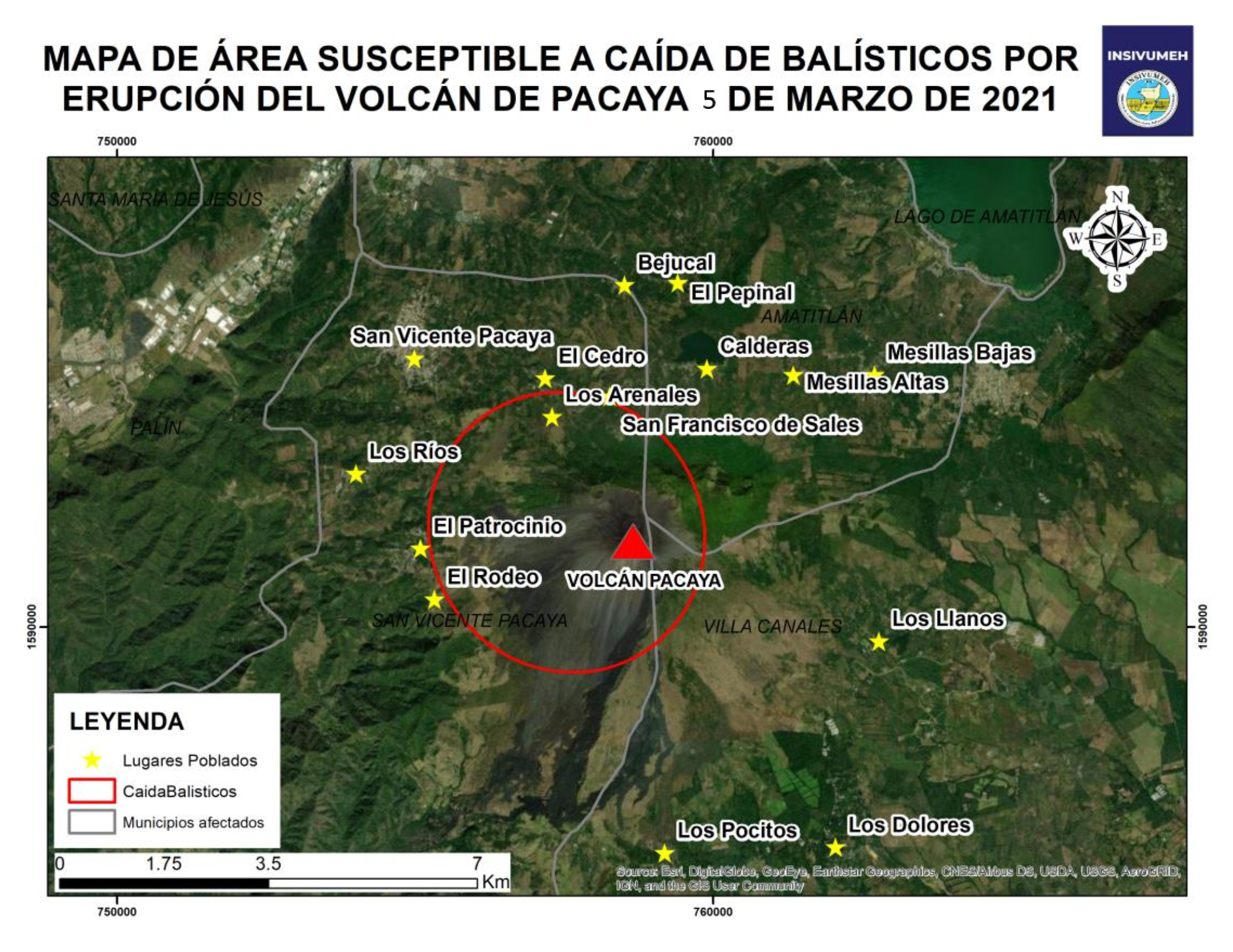
The dispersion of the eruptive column continues to be maintained mainly in a West, Southwest and South direction, which caused ash falls in the communities of Los Rios and Los Jazmines, also in the municipalities of Palín and Escuintla, with the possibility of ash fall in the villages of San Francisco de Sales, El Cedro, Calderas, San Vicente Pacaya and southern communities such as Los Pocitos, the village of Pacaya and other nearby communities.
It is not excluded that the eruption increases, or that it continues with this tendency to maintain intervals of increase and decrease during the next hours, maintaining the explosions with ballistic projections and emissions of ash columns and of gas, as well as the increase in length or the appearance of new lava flows on the flanks around the volcanic cone.
Source : Insivumeh .
Photo : TV7.
Hawaii , Kilauea :
19°25’16 » N 155°17’13 » W,
Summit Elevation 4091 ft (1247 m)
Current Volcano Alert Level: WATCH
Current Aviation Color Code: ORANGE
Activity Summary:
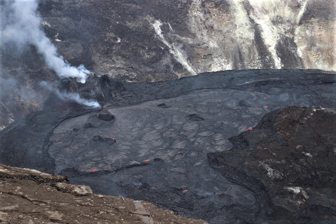
Kīlauea Volcano is erupting. Lava activity is confined to Halemaʻumaʻu, with lava erupting from a vent on the northwest side of the crater and flowing into a growing lava lake. Laser rangefinder measurements this morning, March 5, indicate that the total depth of the lava lake is 220 m (722 ft). SO2 emission rates remain elevated; a measurement on March 3 was 1000 t/day.
The lava lake in Halema‘uma‘u crater remains active. This view looking to the northwest on Wednesday, March 4, 2021, focuses on the active portion of the lake; the eastern stagnant portion is out of view to the right. Lava enters the lake at the base of the western vent spatter cone (left). This photo was taken in an area of Hawai‘i Volcanoes National Park that remains closed to the public due to safety reasons
Summit Observations:
The most recent sulfur dioxide emission rate, measured on March 3, is 1000 t/d; this is elevated compared to rates in the months before the eruption started on December 20 (less than 100 t/day), but lower than rates from the pre-2018 lava lake (around 5,000 t/day). Summit tiltmeters have been flat over the past three days, after tracking a prior deflation-inflation (DI) event. Seismicity remains stable, with elevated tremor compared to observations before the eruption.
Halemaʻumaʻu lava lake Observations:
Lava effusion from the west vent continues to supply the lava lake within Halema‘uma‘u crater through a crusted-over channel and submerged inlet to the lake.
Lava circulation and intermittent foundering of thin crust continue in the active western portion of the lava lake. The total depth of the lake is approximately 220 m (722 ft) as measured by a continuous laser rangefinder this morning, March 5.
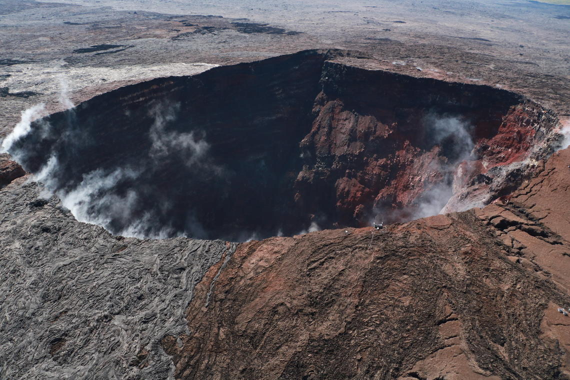
Subtle steaming was visible at Pu‘u ‘Ō‘ō during HVO’s overflight of Kīlauea on March 4, 2021. Steam is normally visible as the vent—which was active for more than 35 years—continues to cool, following the 2018 Pu‘u ‘Ō‘ō collapse. The brown-colored tephra deposits (right) are from the high-fountaining phases early in the Pu‘u ‘Ō‘ō eruption, whereas the silver-grey lava overflows (left) later resurfaced the side of the vent.
Stagnant and solidified lava crust covers the eastern portion of the lava lake and is slowly growing westward around the main island, apparently preventing any lateral movement of this island or any of the smaller enclosed islands. Rangefinder measurements and visual observations indicate that the crust in the eastern portion of the lava lake is still rising at a rate similar to the active western portion of the lake, suggesting continued accumulation of liquid lava below the crust.
Source : HVO.
Photos : USGS/ N. Deligne , USGS / K. Mulliken .


No comment yet, add your voice below!