
February 27 , 2021 .
Iceland , Reykjanes Peninsula :
Earthquake swarm in Reykjanes peninsula , February 26 , 2021 .
Largest one measured was M5.7
On February 24th 2021, two earthquakes above magnitude M5 were recorded. The larger one, M5.7, was at 10:05 and at 10:30 a M5.0 was measured. Later that day at 12:37 a M4.8 was recorded. Since the beginning of this unrest 16 earthquakes above M4 have been recorded and 90 earthquakes above M3. They have been felt widely in the SW part of the country and the larges once in the NW part as far as Ísafjörður. Note that all reviewed earthquakes have occurred on the Reykjanes Peninsula, roughly between Kleifarvatn and Svartsengi.
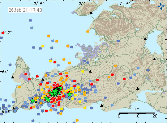
Today five earthquakes above M4 have been measured in the northern part of Fagradalsfjall, M4,4 at 12:06, M4,0 at 12:24, M4,1 at 13:51 og M4,2 at 15:10. All those are in a similar location as the M5,7 earthquake. Our interpretation is that these are triggered earthquakes caused by the intense activity and deformation that has occurred in the area. The swarm is still ongoing and roughly 5000 earthquakes have been detected with the automatic system since the beginning of the swarm.
The satellite image below displays a Sentinel-1 interferogram spanning the period 19-25th February. This shows ground deformation associated with the recent earthquake activity on the Reykjanes Peninsula and indicates this was related to a combination of movement on north-south trending faults and left-lateral movement over a large section of the plate boundary (~25 km segment – from Svartsengi to Kleifarvatn).
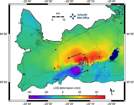
Red amplitudes represent movement towards the satellite and purple amplitudes movement away from the satellite (path is west of Iceland). The black arrows in the right corner below show the heading and look direction of the satellite. The magnitude 5.7 earthquake that occurred on the 24th February is displayed by the red star.
There is no indication in this interferogram for shallow magmatic intrusions, however the inflow of magma from depth cannot be ruled out, as this activity is part of an ongoing volcano-tectonic reactivation of the Reykjanes Peninsula.
Source : Vedur Is.
Philippines , Taal :
TAAL VOLCANO BULLETIN 27 February 2021 08:00 A.M.
In the past 24-hour period, the Taal Volcano Network recorded twenty-eight (28) volcanic earthquakes and one hundred thirty (130) volcanic tremor episodes having durations of one (1) to five (5) minutes. Despite these, only weak steam-laden plumes were emitted by fumarolic activity at the vents of the Main Crater.

Temperature highs of 74.6°C and pH of 1.59 were last measured from the Main Crater Lake respectively on 18 and 12 February 2021. Ground deformation parameters from continuous electronic tilt on Volcano Island record a slight deflation around the Main Crater since October 2020 but overall, very slow and steady inflation of the Taal region has been recorded by continuous GPS data after the eruption.
Source : Phivolcs.
Photo : Tomasz Lepich.
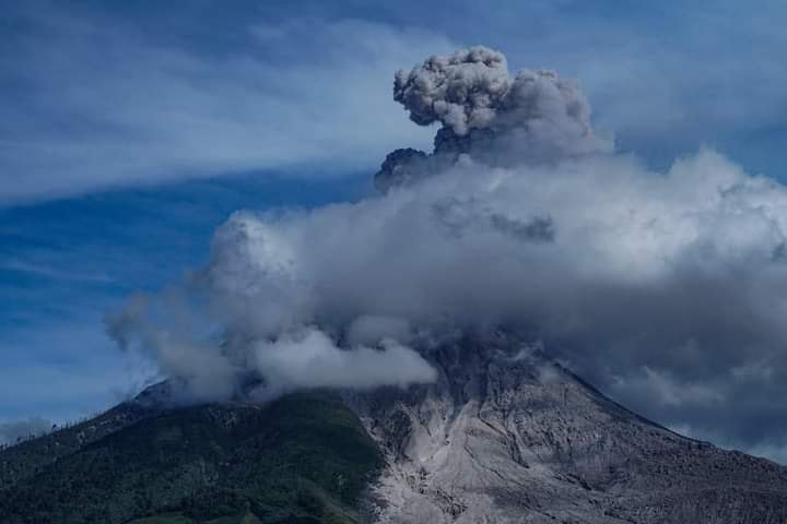
Indonesia , Sinabung :
The activity level has been at level III (SIAGA) since May 20, 2019 at 10:00 a.m. WIB. Mount Sinabung (2460 m above sea level) has been erupting since 2013.
The volcano was clearly visible until it was covered in fog. The crater emits white smoke with a low intensity, rising to about 50-200 meters above the summit. The weather is sunny to cloudy, weak to moderate winds to the east, south, southwest and west. The air temperature is around 16-28 ° C.
According to the seismographs of February 26, 2021, it was recorded:
111 avalanche earthquakes
31 emissions earthquakes
373 low frequency earthquakes
1 local tectonic earthquake
VONA:
The last VONA message was sent with the color code ORANGE, published on February 25, 2021 at 10:14:00 WIB. Volcanic ash had been observed at an altitude of 3,960 m above sea level or about 1,500 m above the summit.
Source : PVMBG.
Photo : India Monsoon.
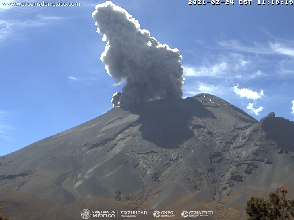
Mexico , Popocatepetl :
February 26, 11:00 a.m. (February 26, 5:00 p.m. GMT)
During the last 24 hours, thanks to the monitoring systems of the Popocatépetl volcano, 92 exhalations and 311 minutes of tremor have been identified, accompanied by emissions of water vapor, volcanic gases and small amounts of ash.
Since this morning and at the time of this report, we have observed a constant emission of volcanic gases and sometimes ash, which disperse in a north-north-west direction.
CENAPRED urges NOT TO APPROACH the volcano and especially the crater, because of the danger posed by the fall of ballistic fragments and, in the event of heavy rains, to stay away from the bottom of the ravines because of the danger of lava flows. mud.
The Popocatépetl volcanic alert semaphore is in YELLOW PHASE 2.
Source : Cenapred .
Hawaii , Mauna Loa :
19 ° 28’30 « N 155 ° 36’29 » W,
Summit Elevation: 13,681 ft (4,170 m)
Current volcanic alert level: NOTICE
Current Aviation Color Code: YELLOW
Summary of the activity:
Mauna Loa volcano is not erupting. Top deformation and seismicity rates continue to increase slightly and remain above background levels for the long term.
Observations:
Over the past week, HVO seismometers have recorded around 271 low-magnitude earthquakes over Mauna Loa, including 226 below the volcano’s summit and beneath the upper flanks. The majority of these summit earthquakes have occurred at shallow depths of less than 6 kilometers (~ 4 miles) below the summit of Mauna Loa and are within the normal range of fluctuations seen in recent years.
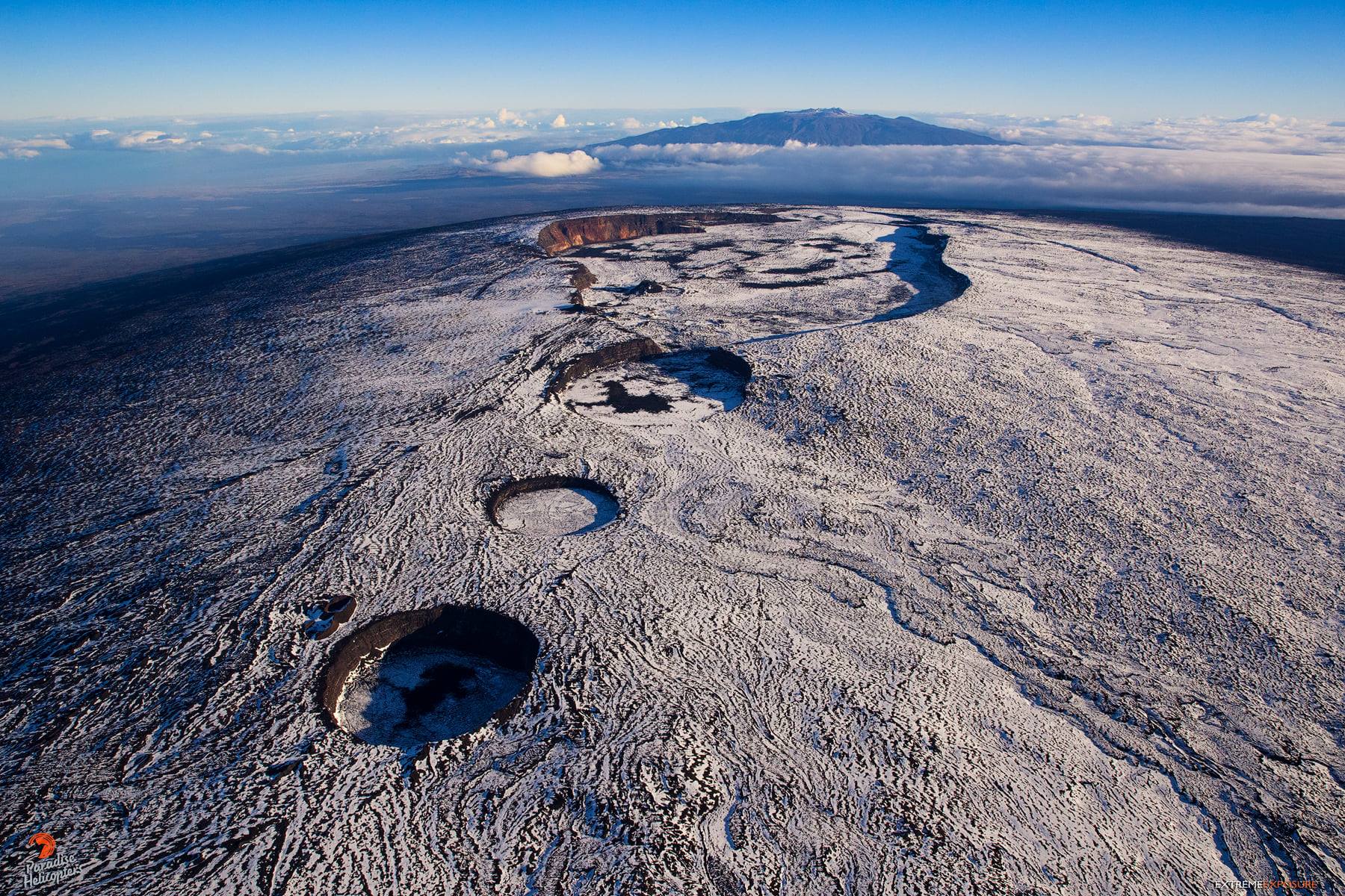
The partially melted snow on the summit of Mauna Loa accentuates the textures of its lava flows below, creating a surreal scene one would not expect to find in tropical Hawai’i!
Global Positioning System (GPS) measurements continue to show slow, long-term inflation at the summit, consistent with the supply of magma to the volcano’s shallow storage system. A slight increase in the peak inflation rate that started in January continues.
Gas concentrations (0 ppm SO2; up to 4 ppm H2S) and fumarole temperatures (below 100 ° C) at the summit and at Sulfur Cone in the Southwest Rift Zone remain stable.
Webcam views showed no change in the scenery over the past week.
Source : HVO


No comment yet, add your voice below!