
February 21 , 2021.
Italy / Sicily , Etna :
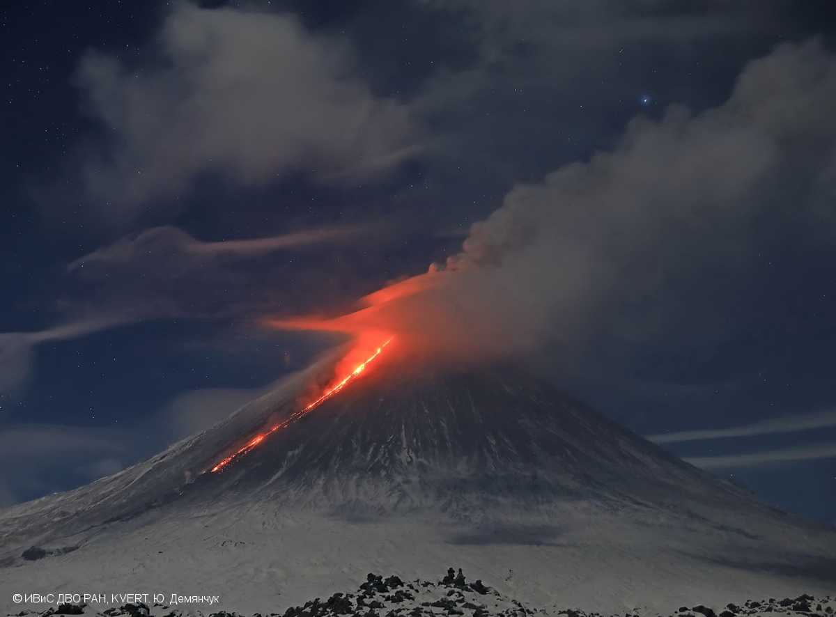
Chronology of last night’s paroxysm.
COMMUNICATION ON THE ACTIVITY OF ETNA [UPDATE n. 147]
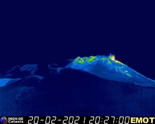
The National Institute of Geophysics and Volcanology, Osservatorio Etneo, reports that weak Strombolian activity is underway at the eastern mouth of the Southeast Crater.
The average amplitude of the volcanic tremor gradually increases; at present, the amplitude is in the middle level.
The source of the tremor is located under the Southeast Crater, at a depth of 2500-2600 m above sea level.
The infrasonic signals also increase in both the frequency of occurrence and the energy of infrasonic transients. These are mainly located in correspondence with the Southeast Crater.
COMMUNICATION ON THE ACTIVITY OF ETNA [UPDATE n. 148]
The National Institute of Geophysics and Volcanology, Osservatorio Etneo, reports that Strombolian activity at the eastern mouth of the Southeast Crater is gradually increasing. In addition, fluctuating glows are observed from a vent further west and up to the « saddle mouth ».
From approximately 19:30 UTC, the average amplitude of the volcanic tremor shows a new sudden increase; currently, the amplitude is in the high level.
The source of the tremor is located under the Southeast Crater, in a depth range of 2600 to 2700 m above sea level.
The infrasonic activity is quite sustained with a high rate of occurrence of infrasonic transients. These are located in correspondence with the Southeast Crater.
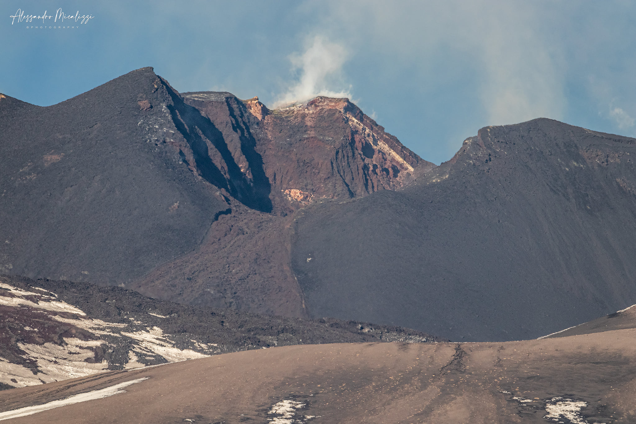
The south-eastern flank torn by the latest paroxysmal events
COMMUNICATION ON THE ACTIVITY OF ETNA [UPDATE n. 149]
The National Institute of Geophysics and Volcanology, Osservatorio Etneo, reports that thanks to surveillance cameras, it is possible to observe an overflow of lava from the eastern mouth of the Southeast Crater, which began shortly after 9:30 p.m. UTC. The lava flow is heading towards the Valle del Bove.
The amplitude of the volcanic tremor continues to increase.
COMMUNICATION ON THE ACTIVITY OF ETNA [UPDATE n. 150]
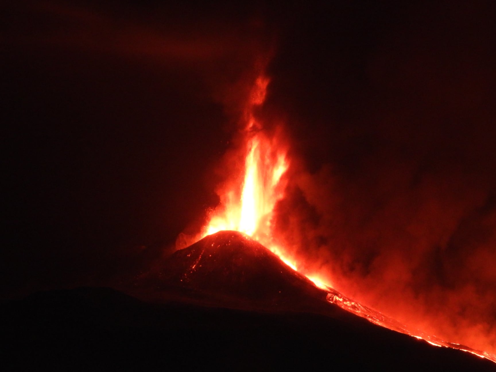
The National Institute of Geophysics and Volcanology, Osservatorio Etneo, reports that activity at the eastern mouth of the Southeast Crater has gradually shifted to a pulsating lava fountain. The lava flow generated by the overflow on the eastern flank of the cone, previously communicated, traveled about 150-200 m.
The average amplitude of the volcanic tremor shows high values with an increasing trend. The source of the tremor is located under the Southeast Crater, in a depth range of 2800 to 2900 m above sea level.
Infrasound activity has also reached high levels; the rate of occurrence and the energy of infrasonic transients increase.
COMMUNICATION ON THE ACTIVITY OF ETNA [UPDATE n. 151]
The National Institute of Geophysics and Volcanology, Osservatorio Etneo, reports that the activity of the lava fountain has further intensified, however remaining confined to the eastern part of the Southeast Crater. A relatively diluted eruptive column forms at the top of the volcano.
The lava flow directed towards the Valle del Bove has reached a length of about 1 km, with a front that reaches about 2800 m.
The average amplitude of the volcanic tremor shows high values with a tendency to increase more. The location of the source of the tremor remains under the Southeast Crater.
The infrasonic signals also increase in both the frequency of occurrence and the energy of infrasonic transients.
The distortion data from the GPS network does not record significant variations, while the inclinometric network shows limited variations (0.1 – 1 microradians).
COMMUNICATION ON THE ACTIVITY OF ETNA [UPDATE n. 152]
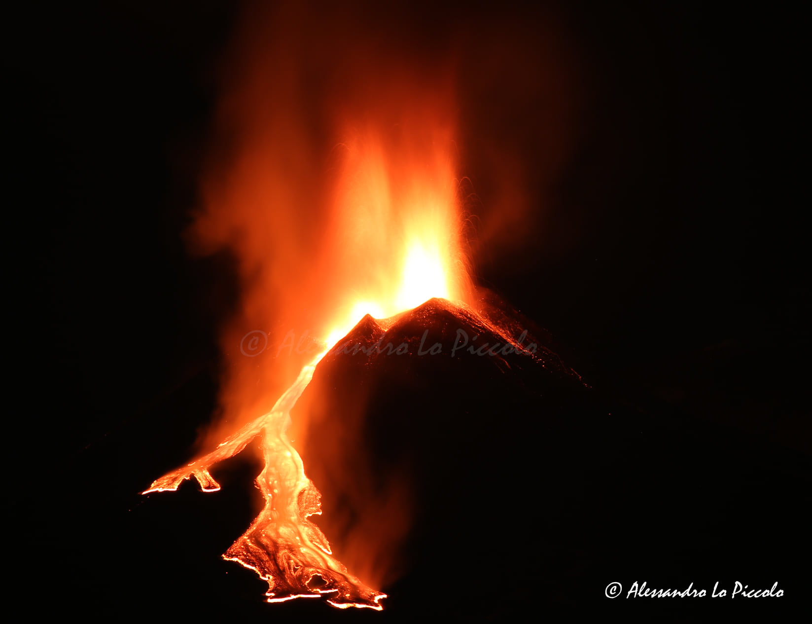
The National Institute of Geophysics and Volcanology, Osservatorio Etneo, reports that other vents were activated on the Southeast Crater, towards the « mouth of the saddle », producing lava fountains and Strombolian activity. At 12:28 a.m., activity suddenly intensified, generating columns of lava at an altitude of 800-1000 m above the Southeast Crater. Shortly thereafter, an overflow of lava began from the « saddle mouth », feeding a lava flow directed towards the southwest.
An eruptive column rose several kilometers above the summit of Etna.
The average amplitude of the volcanic tremor reached very high values, higher than those recorded in previous paroxysms. The location of the source of the tremor remains under the Southeast Crater.
The infrasonic signals also show very high values in both the rate of occurrence and the energy of infrasonic transients.
During the current eruptive event, the deformation data confirms modest variations recorded on the inclinometric network.
COMMUNICATION ON THE ACTIVITY OF ETNA [UPDATE n. 153]
The National Institute of Geophysics and Volcanology, Osservatorio Etneo, announces that between 1:00 a.m. and 1:15 a.m., the eruptive activity at the Southeast Crater declined rapidly and completely ceased at around 1:20 a.m. The lava flows are still advancing slowly, the fronts of the longest flow in Valle del Bove, measure about 3.5 to 4 km from the mouth and is at an altitude of between 1700 and 1800 m. The southwest lava flow has only traveled a few hundred meters.
From 00:50 UTC, the average amplitude of the volcanic tremor underwent a sudden and drastic decrease in its values and reached the average level around 01:30 UTC. Currently, the parameter shows the tendency to decrease further.
At the same time, infrasound signals also show a marked reduction in explosive activity.
Further updates will be communicated shortly.
Source : INGV.
Photos : INGV , Alessandro Micalizzi , Boris Behncke , © Alessandro Lo Piccolo.
Kamchatka , Klyuchevskoy :
VOLCANO OBSERVATORY NOTICE FOR AVIATION (VONA).
Issued: February 21 , 2021
Volcano: Klyuchevskoy (CAVW #300260)
Current aviation colour code: YELLOW
Previous aviation colour code: yellow
Source: KVERT
Notice Number: 2021-29
Volcano Location: N 56 deg 3 min E 160 deg 38 min
Area: Kamchatka, Russia
Summit Elevation: 4750 m (15580 ft)
Volcanic Activity Summary:
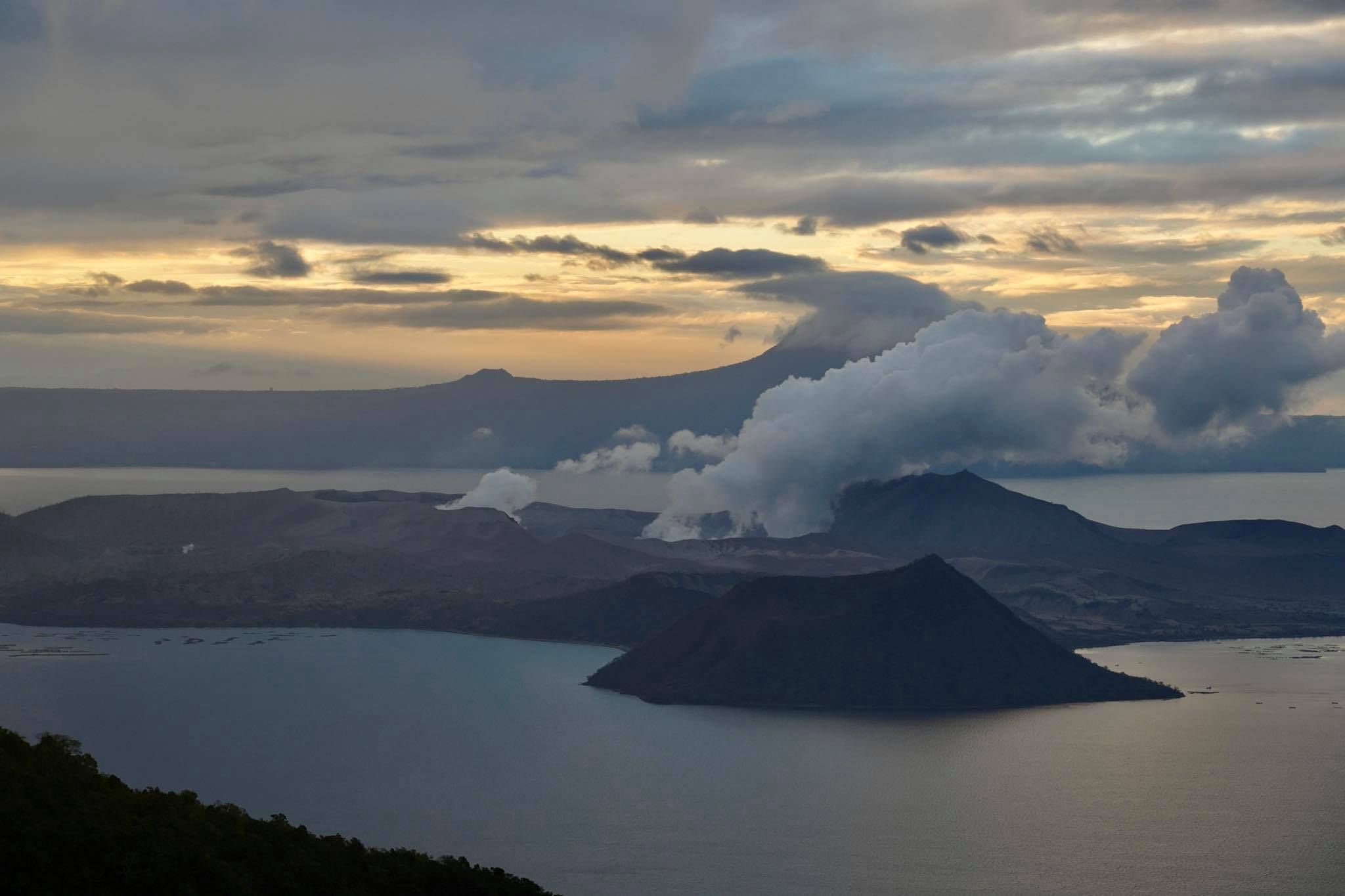
According to satellite data from the VolSatView Information System, and video data, a flank eruption (lateral break) began to form on the northwestern slope of Klyuchevskoy volcano between 23:00 – 23:50 UTC on 17 February, 2021, and the eruption continues. A snowfall continues in the area of Klyuchi for the last few days, for 17-19 February there is no video data. A bright incandescence over the flank eruption began to observe from 15:23 UTC on 20 February at video-data by IVS FEB RAS. Probably a lava flow began to move from a lateral break. The flank eruption form on the altitude about 2.5-2.7 km a.s.l. near the Erman glacier. There is a real danger of mud flows for the Klyuchi Village. KVERT continues to monitor Klyuchevskoy volcano.
A moderate gas-steam activity of the volcano continues. The danger of ash explosions up to 19,700-23,000 ft (6-7 km) a.s.l. remains. Ongoing activity could affect low-flying aircraft.
Volcanic cloud height: NO ASH CLOUD PRODUSED
Other volcanic cloud information: NO ASH CLOUD PRODUSED
Source : Kvert.
Photo : Yu. Demyanchuk, IVS FEB RAS, KVERT ( Janvier 2021 ).
Philippines , Taal :
TAAL VOLCANO BULLETIN 21 February 2021 08:00 A.M.
In the past 24-hour period, the Taal Volcano Network recorded seventeen (17) tremor episodes having durations of sixty (60) to three hundred sixty (360) seconds. Activity in the Main Crater consisted of weak emission of white steam-laden plumes from fumaroles that rose 5 meters high. Temperature highs of 74.6°C and pH of 1.59 were last measured from the Main Crater Lake respectively on 18 and 12 February 2021.
Ground deformation parameters from continuous electronic tilt on Volcano Island record a slight deflation around the Main Crater since October 2020 but overall, very slow and steady inflation of the Taal region has been recorded by continuous GPS data after the eruption.
DOST-PHIVOLCS is closely monitoring Taal Volcano’s activity and any new significant development will be immediately communicated to all stakeholders.
Source : Phivolcs
Photo : Raffy Tima .
Indonesia , Sinabung :
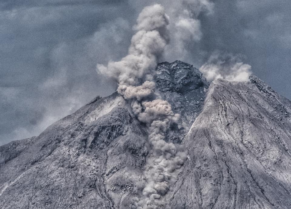
The activity level has been at level III (SIAGA) since May 20, 2019 at 10:00 a.m. WIB. Mount Sinabung (2460 m above sea level) has been erupting since 2013.
The volcano was clearly visible until it was covered in fog. The crater emits white smoke with a low intensity, rising about 50-300 meters above the summit. The weather is sunny, with light to moderate winds to the south, east and west.
According to the seismographs of February 20, 2021, it was recorded:
– 149 avalanche earthquakes
– 4 earthquakes of emissions.
– 21 low frequency earthquakes
– 106 hybrid / multi-phase earthquakes
– 4 deep volcanic earthquakes
– 1 distant tectonic earthquake.
Source : PVMBG.
Photo : Nachelle Homestay
Guatemala , Pacaya :
SPECIAL VOLCANOLOGICAL BULLETIN, February 20, 2021, 9:06 p.m. local time.
ACTIVITY UPDATE.
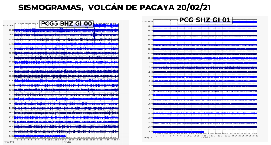
As mentioned in previous bulletins, the Pacaya maintains constant activity, with a series of pulses of eruptive augmentation, where Strombolian explosions are generated expelling volcanic, ballistic material at a height of 100 to 300 meters above the crater. During these periods, thick columns of ash rise to an altitude of 3,000 meters (9,842 feet) as the strong wind from the region shifts south and southwest from the slopes of the volcano for a distance of 10 to 25 kilometers, with the possibility of extending further. The lava flow on the southern flank remains active, with a length of 1000 meters.
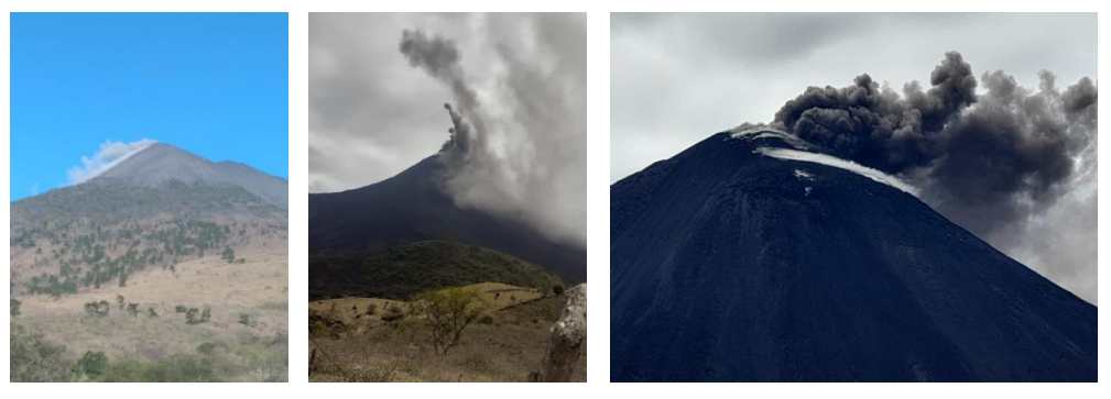
It is not excluded that the volcanic activity generates new impulses of increase in the hours or the next days, which produce more emissions of ash columns, explosions with ballistic projections, as well as the increase of the length or the emergence of new lava flows on the flanks around the volcanic cone.
Source et photos : Insivumeh .


No comment yet, add your voice below!