
February 18 , 2021.
Italy / Sicily , Etna :
COMMUNICATION ON THE ACTIVITY OF ETNA [UPDATE n. 133].
The National Institute of Geophysics and Volcanology, Osservatorio Etneo, announces that during the night and dawn of February 17, the eastern mouth of the southeast crater was the site of continued Strombolian activity, which has almost completely ceased at 6.15 am. There were also sporadic explosions of the Voragine crater, in particular at 3:20 am, 3:35 am and 3:44 am.
As of around 7 p.m. UTC last night, the average amplitude of the volcanic tremor has roughly stabilized within the range of average values, showing between 3 a.m. and 4 a.m. UTC today a slight increase.

Subsequently, the parameter showed a decrease, reaching values for about two hours almost at the transition to the low level.
The location of the volcanic tremor is localized in the area of the summit craters, affected by the different sources which are activated under each single active crater, in a depth range between 2500m and 2800m. During the phase of slight increase in the amplitude of the tremor (between 3h and 4h UTC), the source of the tremor was mainly located under the Southeast crater.
With regard to infrasonic signals, after the weak activity which characterized the hours immediately following the lava fountain episode yesterday afternoon, there was a resumption of explosive activity at the end of the evening, which from the early hours of today has become even more intense, with a high rate of occurrence and transient energy until around 6am UTC. Subsequently, until the present moment, the infrasonic activity decreases.
The distortion data from the GPS and inclinometric networks do not show any significant changes.
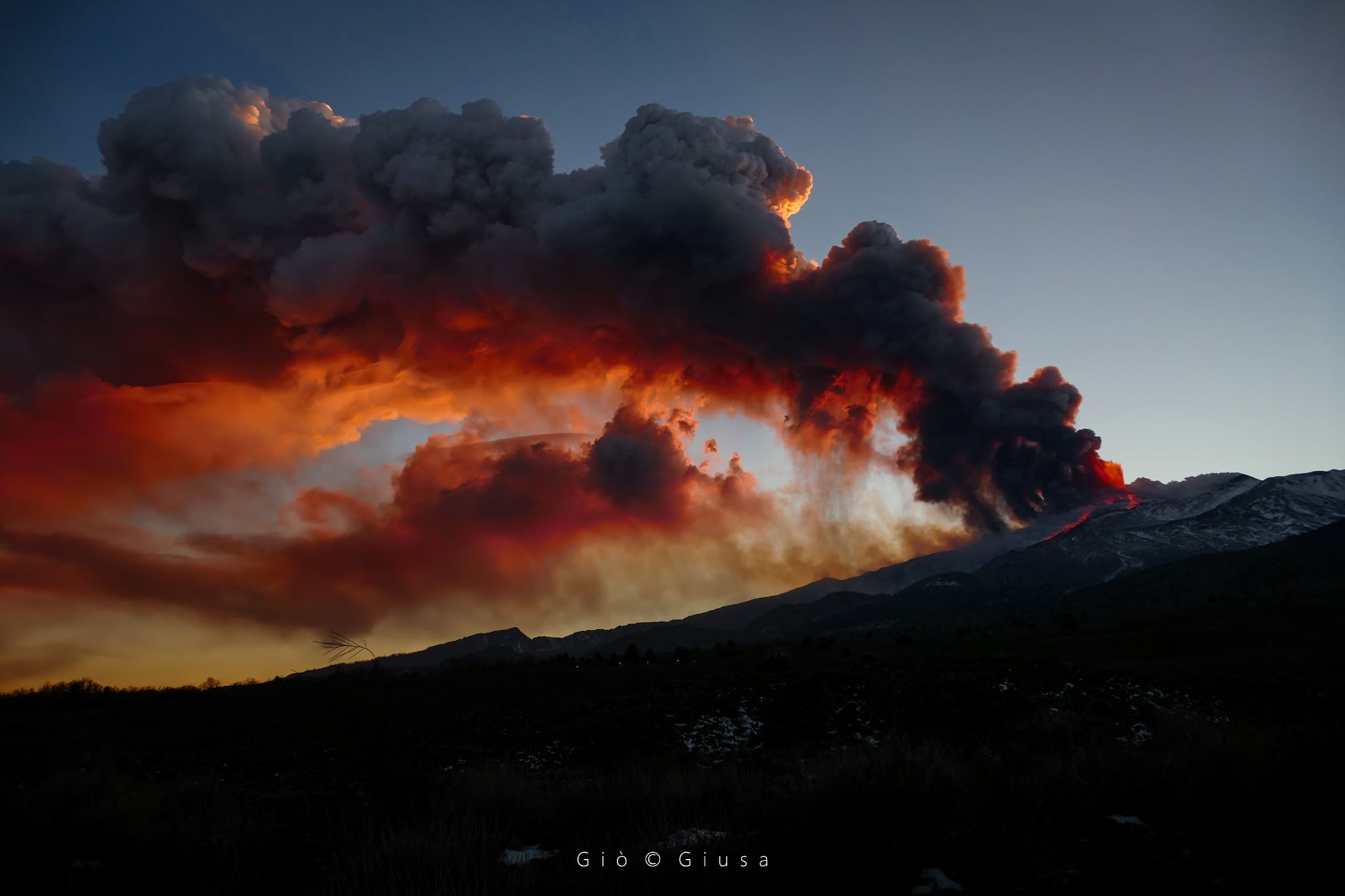
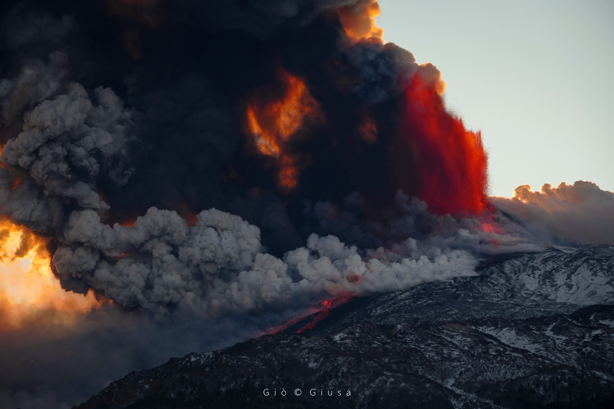
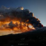
At the start of the paroxysmal episode in the late afternoon of February 16, 2021, the rapid accumulation of bombs and waste and the start of emission of a lava flow caused the landslide of part of the cone of the Southeast Crater .. The sliding of this hot material turned into a pyroclastic flow, which traveled about 1.5 km on the western wall of the Bove valley, towards the east of the volcano. Subsequently, the activity developed in the classic manner of an Etnean paroxysm, with tall lava fountains and lava flows (all towards the Bove valley) and an eruptive column several kilometers from high, driven by the wind towards the South, causing fallout of ash and lapilli on many inhabited centers, including the city of Catania.
The video of the first minute of this video was recorded from Tremestieri Etneo, 20 km south of the volcano, and is reproduced here accelerated 2.5 times compared to the actual speed. Subsequently, we see the recording of the thermal surveillance camera placed on Monte Cagliato, on the eastern slope of Etna, (10 minutes which are compressed into 30 seconds of video).
This is not the first time that a phenomenon of this type has occurred on Etna. During the rapidly intensifying phase of explosive activity at the start of the climax of December 13-14, 2020, the southern mouth of the same Southeast Crater (also known as the ′ ′ saddle mouth ′ ′) was was the site of three pyroclastic flows which traveled several hundred meters at the southwest base of the cone. A more significant event occurred on February 11, 2014, when part of the eastern flank of the Southeast Crater was shaken generating a pyroclastic flow about 3 km long in the Valle del Bove.
COMMUNICATION ON THE ACTIVITY OF ETNA [UPDATE n. 134].
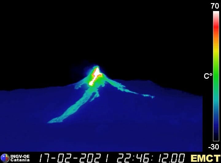
The National Institute of Geophysics and Volcanology, Osservatorio Etneo, announces that with the help of surveillance cameras a new lava overflow from the Southeast Crater is observed, which began shortly before 22:30 UTC. The lava flow descends the eastern slope of the cone, heading towards the Valle del Bove. The amplitude of the tremor increases and is high.
COMMUNICATION ON THE ACTIVITY OF ETNA [UPDATE n. 135].
The National Institute of Geophysics and Volcanology, Osservatorio Etneo, announces that lava fountain activity is underway at the Southeast Crater. The lava flow reported in the previous press release has currently traveled approximately 1 km, with a front at an altitude of approximately 2,700 m. An eruptive column heads south-east.
COMMUNICATION ON THE ACTIVITY OF ETNA [UPDATE n. 136].
The National Institute of Geophysics and Volcanology, Osservatorio Etneo, announces that in addition to the lava flow reported in the previous press release (n.135), there is a second flow that flows from the northern flank from the Southeast Crater, heading towards the Valle del Leone.
The average amplitude of the volcanic tremor shows high values with an increasing trend. The source of the tremor is located under the Southeast Crater, in a depth range of 2800 to 2900 m.
The infrasonic activity appears to be high, both for the frequency of occurrence of infrasonic transients and for their amplitude. The infrasound sources are located at the Southeast Crater.
COMMUNICATION ON THE ACTIVITY OF ETNA [UPDATE n. 137].
The National Institute of Geophysics and Volcanology, Osservatorio Etneo, reports that the lava fountain activity ended at around 12:55 UTC. The lava flows are still advancing slowly but are no longer fed. The main lava flow extends to the bottom of the Valle del Bove at an elevation just below 2000 m, having traveled 3.5 to 4 km A smaller flow directed towards the Valle del Leone is about 1 km from long with a front at an altitude of about 2900 m. Another overflow occurred on the southern flank of the Southeast Crater, feeding a small flow to the southwest.
The eruptive cloud was pushed by the wind towards the South-East, causing fallout of ash and lapilli on the localities of this sector of the volcano.
After reaching the maximum value around 00:10, the average amplitude of the volcanic tremor decreased rapidly and now has average values, much lower than those recorded before the lava fountain. The source of the tremor is located in coincidence with the Southeast Crater, at a depth of about 2800 m above sea level.
The infrasonic activity also decreased significantly, with low values in both the rate of occurrence and the mean amplitude of infrasonic transients.
The deformation data from the GPS network did not record any significant variations, while the signals from the inclinometric network showed limited variations concomitant with the eruptive activity.
Further updates will be communicated shortly.
Source : INGV. Boris Behncke .
Photos : Gio Giusa .
Colombia , Nevado del Ruiz :
Weekly activity bulletin of the Nevado del Ruiz volcano
The activity level continues at Yellow Activity Level or (III): changes in the behavior of volcanic activity.
Regarding the monitoring of the activity of the Nevado del Ruiz volcano, the COLOMBIAN GEOLOGICAL SERVICE reports that:
Seismicity generated by rock fracturing increased in the number of recorded earthquakes and maintained levels of seismic energy released similar to the previous week. This seismic activity was located mainly in the distal North, North-East, South-East, South-South-West and West-South-West sectors of the volcano and in the Arenas crater. The depths of the earthquakes ranged from 0.5 to 7.4 km. The highest magnitude recorded during the week was 0.6 ML (local magnitude), corresponding to the earthquake that occurred on February 9 at 3:07 a.m. (local time), located 4.5 km to the South-South-West from the crater, at a depth of 3.9 km.
Seismicity linked to fluid dynamics, inside volcanic conduits, maintained a similar level in the number of events and increased in seismic energy released compared to the previous week. This seismic activity was characterized by the occurrence of continuous volcanic tremor, tremor pulses, long and very long period type earthquakes, which presented variable energy levels and spectral content. The earthquakes were located in the Arenas crater.
The deformation of the volcanic surface, measured from GNSS (Global Navigation Satellite System) stations and electronic inclinometers continued to show some minor changes on the volcano.
Source : Ingeominas .
Photo : C Rios.
Philippines , Kanlaon :
KANLAON VOLCANO BULLETIN 18 February 2021 08:00 A.M.
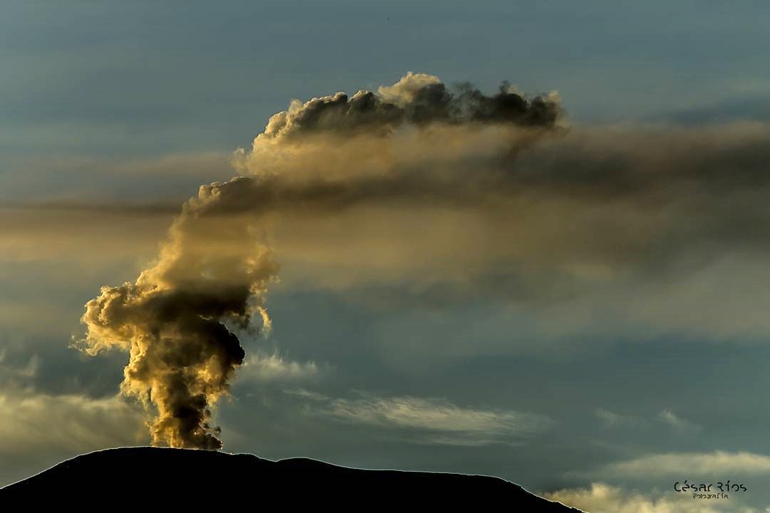
Kanlaon Volcano’s monitoring network recorded seven (7) volcanic earthquakes during the 24-hour observation period. Moderate emission of white steam-laden plumes that rose 300 meters before drifting northwest and southwest was observed. Sulfur dioxide (SO2) emission was measured at an average of 587 tonnes/day on 17 February 2021. Ground deformation data from continuous GPS and electronic tilt measurements have been recording a slight inflation of the lower and middle slopes since June 2020. These parameters may indicate hydrothermal, tectonic, or deep-seated magmatic processes occurring deep beneath the edifice.
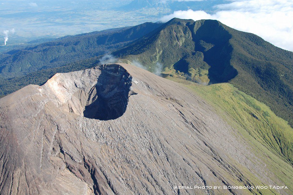
PHIVOLCS reported slightly increased seismic activity and volcanic gas flux at Kanlaon. The seismic network recorded 28 volcanic earthquakes during 11-13 February with local magnitudes between 0.7 and 2.2. They were located at shallow depths around 10 km across the N to E portions of the edifice. The sulfur dioxide emission rate on 13 February was 1,130 tonnes per day, the highest value recorded this year; sulfur dioxide emissions had been higher than background levels of 300 tonnes/day since June 2020. Ground deformation data from continuous GPS and tilt measurements indicated slight inflation of the lower and middle flanks since June 2020. Increased seismic activity continued through 16 February; from 0800 on 14 February to 0800 on 16 February there were a total of 59 earthquakes. The Alert Level remained at 1 (on a scale of 0-5) .
PHIVOLCS reminded the public to remain outside of the 4-km-radius Permanent Danger Zone.
Source : Phivolcs . GVP .
Photo : BongBong Woo Tadifa.
Saint Vincent , Soufrière Saint Vincent :
LA SOUFRIÈRE BULLETIN FEBRUARY 17, 2021 12:00 PM
All monitoring data indicate that the ongoing effusion (outflow) of magma onto the crater floor continues.
The overall rate of growth since onset of dome growth is approximately 1.9 cubic metres per second. There are no clear indications that the activity is either increasing or decreasing in intensity, but there are periodic changes in the rate at which dome growth is occurring.
Measurements of the gas emissions (releases) from the new dome, as well as a preliminary visual inspection of rock samples collected from the dome is indicative of new magmatic material from depth, contributing to the lava extrusion now taking place in the crater.
There is a clear gas plume (column/cloud/trail)from the dome that is damaging the vegetation in the summit areas on the south-west of the volcano.
The National Emergency Management Organisation is reminding the public that no evacuation order or notice has been issued.
NEMO continues to appeal to the public to desist from visiting the La Soufrière Volcano, especially going into the crater, since doing so is extremely dangerous.
Source : Nemo .


No comment yet, add your voice below!