
February 09 , 2021 .
Alaska , Semisopochnoi :
AVO/USGS Volcanic Activity Notice
Current Volcano Alert Level: WATCH
Previous Volcano Alert Level: ADVISORY
Current Aviation Color Code: ORANGE
Previous Aviation Color Code: YELLOW
Issued: Monday, February 8, 2021, 2:11 PM AKST
Source: Alaska Volcano Observatory
Notice Number: 2021/A13
Location: N 51 deg 55 min E 179 deg 35 min
Elevation: 2625 ft (800 m)
Area: Aleutians
Volcanic Activity Summary:
High-resolution satellite imagery on February 7 shows a second small ash deposit extending at least 3 km to the northeast from North Cerberus Crater on Semisopochnoi Island, similar to the first observed on February 6. Clouds obscured views into the crater and the southern side of the volcano. Any ash clouds associated with these deposits have not been observed and are likely low-level (<10,000 ft) and short-duration. Because of evidence for continued low-level ash emissions, the Alaska Volcano Observatory is increasing the Aviation Color Code to ORANGE and the Volcano Alert Level to WATCH.
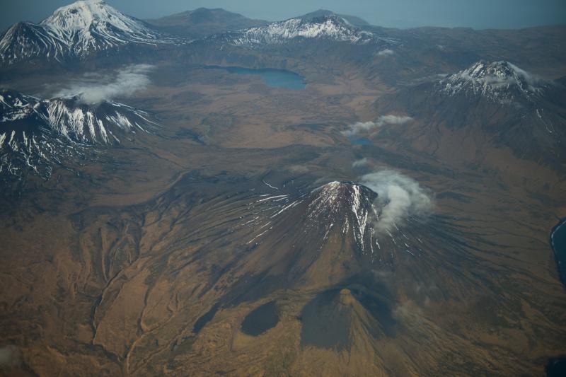
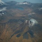
Aerial view, north-northeast at the top, of Semisopochnoi caldera. The large lake in the distance is Fenner Lake. Weakly thermal springs are found downstream along the lake outlet. In the foreground is Sugarloaf Peak, the likely location of the 1987 eruption reported from Semisopochnoi. Details of this eruption are few and far between. At the left margin of the photo are the three summits of cones that make up Mount Cerberus, another young post-caldera vent complex.
Small eruptions producing minor ash deposits within the vicinity of the volcano are typical of activity during unrest at Semisopochnoi since September 2018. Local seismic stations have been offline since November 11, 2020. New explosions could occur at anytime with no warning.
Recent Observations:
[Volcanic cloud height] n/a
[Other volcanic cloud information] n/a
Remarks:
Semisopochnoi is monitored remotely by satellite and lightning sensors. An infrasound array on Adak Island could detect explosive emissions from Semisopochnoi with a 13 minute delay if atmospheric conditions permit.
Source : AVO.
Photo : Roger Clifford , 11/2012 .
Peru , Sabancaya :
Analysis period: from February 01, 2021 to February 07, 2021, Arequipa, February 08, 2021.
Alert level: ORANGE
The Geophysical Institute of Peru (IGP) reports that the eruptive activity of the Sabancaya volcano remains at moderate levels, that is, with the recording of an average of 45 daily explosions, with columns of ash and of gas up to an altitude of 3.0 km above the summit of the volcano and their consequent dispersion. Therefore, for the following days, no significant change is expected in the eruptive activity.
The IGP recorded and analyzed the occurrence of 1548 earthquakes of volcanic origin, associated with the circulation of magmatic fluids inside the Sabancaya volcano. An average of 45 explosions were recorded daily of low to medium intensity. During this period, Volcano-Tectonic (VT) earthquakes associated with rock fractures were located mainly in the North-East of Sabancaya and presented magnitudes between M2.2 and M2.7.

The monitoring of the deformation of the volcanic structure using GNSS techniques (processed with fast orbits) does not present any significant anomalies. However, in general, an inflation process has been observed in the south-eastern sector of Sabancaya and the northern sector (around the Hualca Hualca volcano). Visual surveillance made it possible to identify columns of gas and ash up to 3.0 km altitude above the summit of the volcano, which were scattered towards the South, South-West, East, North-West and North-East of Sabancaya. Satellite monitoring made it possible to identify the presence of two thermal alerts, with values between 1 and 2 MW which are associated with the presence of a Févrieir dome, of lava on the surface of the volcano’s crater. On February 04, COE Caylloma reported the descent of lahares in the south-eastern sector of the Sabancaya volcano (Sallalli sector). The seismic signal was recorded from 11:15 a.m.
RECOMMENDATIONS
• Keep the volcanic alert level in orange.
• Do not approach within a radius of less than 12 km from the crater.
Source : IGP.
Photo : Zintia Roxana Fernández Licla.
Saint Vincent , Soufrière Saint Vincent :
LA SOUFRIÈRE BULLETIN FEBRUARY 8, 2021 8:00 PM
An investigation was conducted at the Wallibou Hot Spring area on Sunday 7th February, 2021 based on a report of irregular temperatures and unusual gas smells there. Some gas sampling was done by Dr. Thomas Christopher, the temperature was taken at different points and some liquid samples were collected for further analysis.
The deformation network is functional. Successful hits of the Electronic Distance Measurement (EDM) target were recorded on the volcano rim from Richmond Vale, Troumaca, Rose Hall, Belmont, and Cherry Hill Chateaubelair. Base line data is being collected. The EDM Network is used to assist with measurements of deformation associated with the flanks of the volcano.
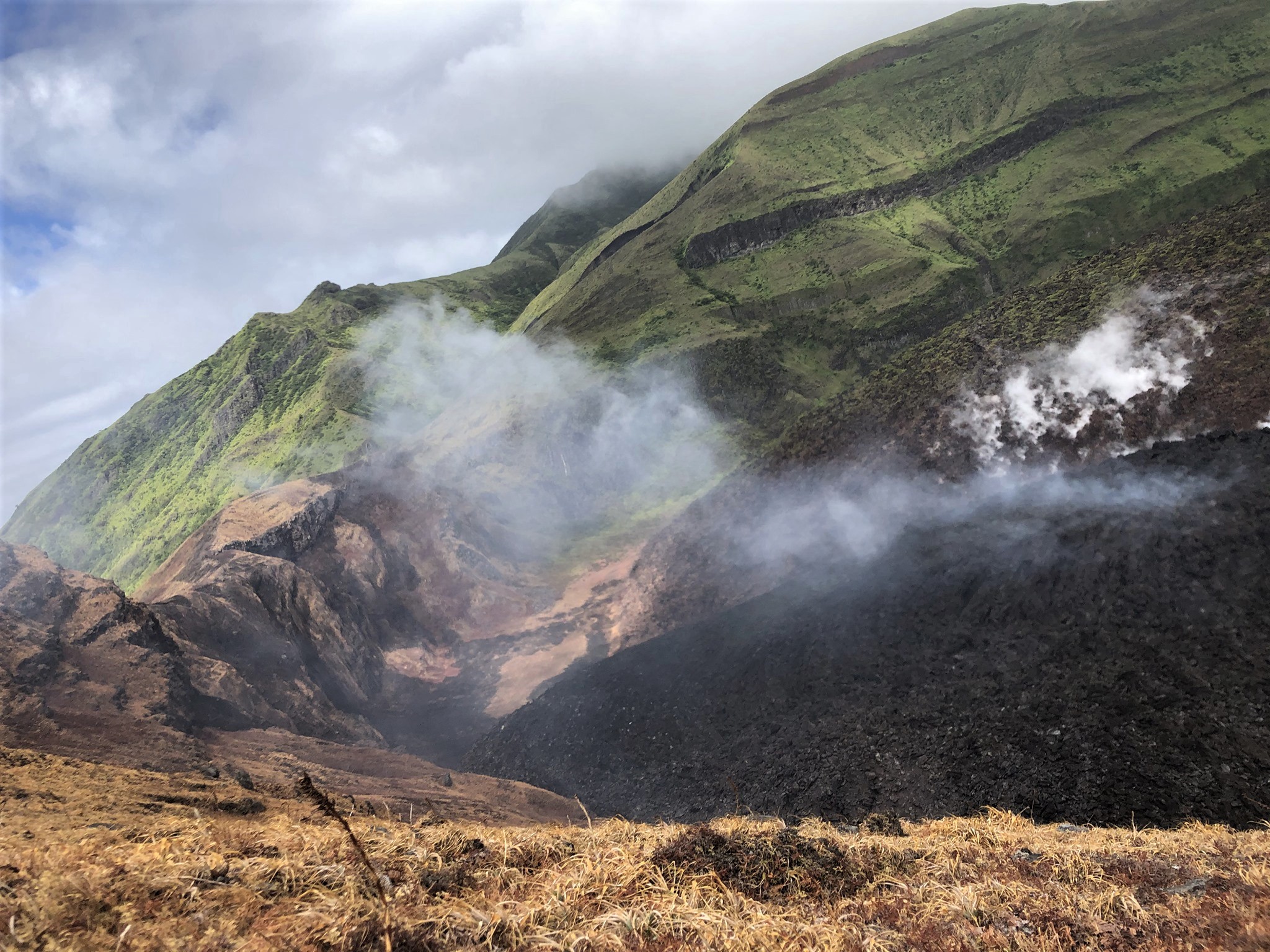
View of the western side of the crater. The new dome is spreading along the crater floor and the vegetation on the crater wall has been burnt (black areas).
NEMO staff will be conducting a drive through in the Cumberland and Coulls Hill communities on Tuesday 9th February, 2021. The purpose of this drive through is to update residents on the state of the La Soufrière Volcano, and to provide information on evacuation procedures and individual preparedness.
The new dome continues to grow with lateral spreading of material towards the north and south, with a preferred northward growth observed.
Damage to vegetation, from acidic gases emitted from the growing dome, downslope of the summit continues to be observed.
The National Emergency Management Organisation is reminding the public that no evacuation order or notice has been issued.
NEMO continues to appeal to the public to desist from visiting the La Soufrière Volcano, especially going into the crater, since doing so is extremely dangerous.
Source : Nemo .
Photo : Monique Johnson.
Guatemala , Pacaya :
SPECIAL VOLCANOLOGICAL BULLETIN February 8, 2021, 1:53 p.m. local time
ASH DISPERSION
Type of activity: Strombolian.
Morphology: composite stratovolcano
Geographical location: 14 ° 22’50˝ Latitude N; 90 ° 36’00˝ Longitude W
Height: 2552msnm.
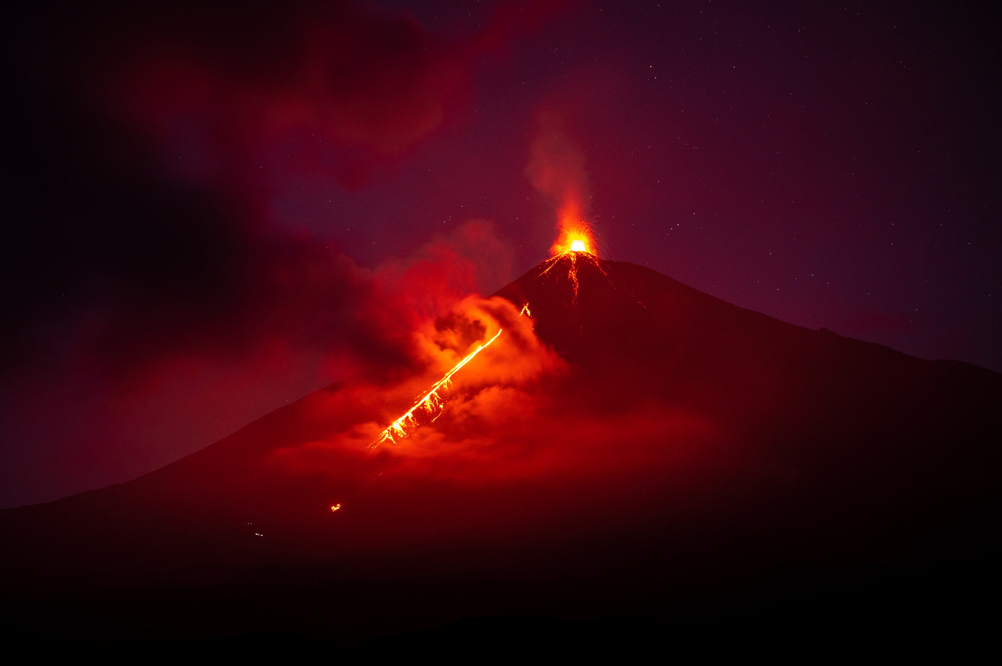
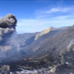
The Pacaya volcano during the last 12 hours has generated abundant ash columns, but their direction of dispersion has been variable. During the morning hours, the ashes reached heights of 3,100 meters (10,170 feet) and dispersed in a northwest and west direction, moving up to 30 kilometers. Likewise, a scattering in the north direction was observed, moving up to 10 kilometers. It is important to remember that the wind direction at the height of the crater can suddenly change and generate ash falls in the communities around the volcanic building, as well as affect the flight lines towards International Airport la Aurora. Accompanying this activity, ballistic projections are observed on the flanks of the Mackenney cone at a distance of up to 300 meters from the crater.
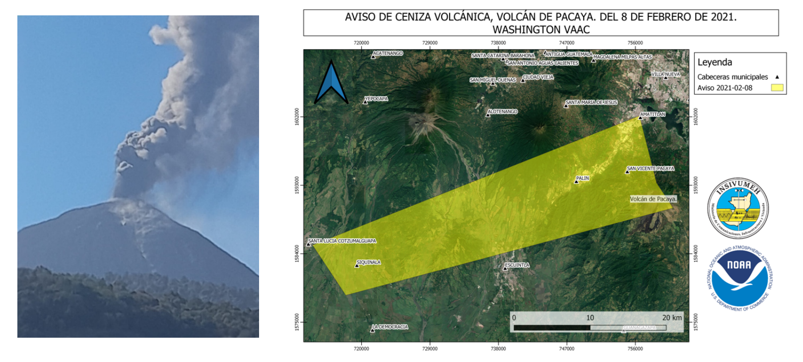
The left image shows the column of ash, dispersing northwest at 9:23 a.m. It is possible to observe the ballistic projections moving on the western flank. The image on the right is the ash release notice generated by the Washington VAAC. The dispersion polygon includes part of the north and northwest flanks. The height of the displaced column is 3354 meters above sea level (11,003 feet).
According to the forecast for the wind direction for the afternoon, it is predicted that the wind will move from South to North, increasing the likelihood of ash falling northward and movement over greater distances. Strombolian activity on the Pacaya volcano is characterized by the generation of high columns of degassing and explosions that can project incandescent materials 25 to 250 meters above the crater. This activity could increase or be maintained at the same level for several hours or days. INSIVUMEH permanently ensures visual and instrumental surveillance, through seismic stations and OVPAC observers.
Source : Insivumeh .
Photos : Diego Rizzo ( @diegorizzophoto ) , Insivumeh .


No comment yet, add your voice below!