
January 09 , 2021 .
Saint Vincent and the Grenadines , Soufrière Saint Vincent :
LA SOUFRIÈRE BULLETIN , JANUARY 8, 2021 8:00 PM
The dome that broke through the crater floor, on December 27, 2020, on the south-west perimeter of the existing dome, continues to grow within the crater of La Soufrière and has an ellipsoid shape with growth expanding in a westerly direction.
The SRC Team spent the day preparing equipment for deployment. The Team also did visual observation of the mountain, which included observation of the emission of gas, taking still photos and videos, as these will help to determine the location to place instruments to monitor the flow of gas.
A reconnaissance mission to Fancy and Owia to identify suitable locations for the installation of additional seismic stations was done today.
Seismic data from the Wallibou station is now streaming into the Seismic Research Centre (SRC).
A webcam providing live feed was installed on January 3, 2021 at the Belmont Observatory. A second camera, at Georgetown was successfully installed and Camera and weather station installations, at the summit, are still being pursued.
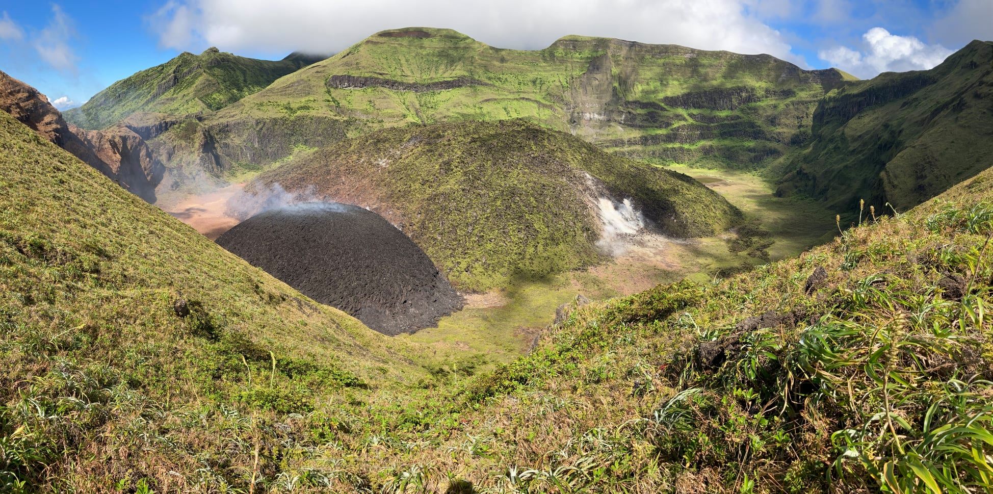
In preparation for the installation of stations at the summit, seismic and ground deformation monitoring equipment are being mobilised to Georgetown to facilitate easier movement of equipment for deployment to the sites identified on the volcano.
Alert level remains at Orange. The volcano continues to exude magma on the surface and steam can still be observed from the Belmont Observatory. Persons living in areas close to the volcano should expect strong sulphur smells for several days to weeks, depending on changes in wind direction.
Source : Nemo .
Vidéo : Professeur Richard Robertson
Photo : Nemo .
Indonesia , Merapi :
Mount Merapi Activity Report, January 1-7, 2021
OBSERVATION RESULT
Visual
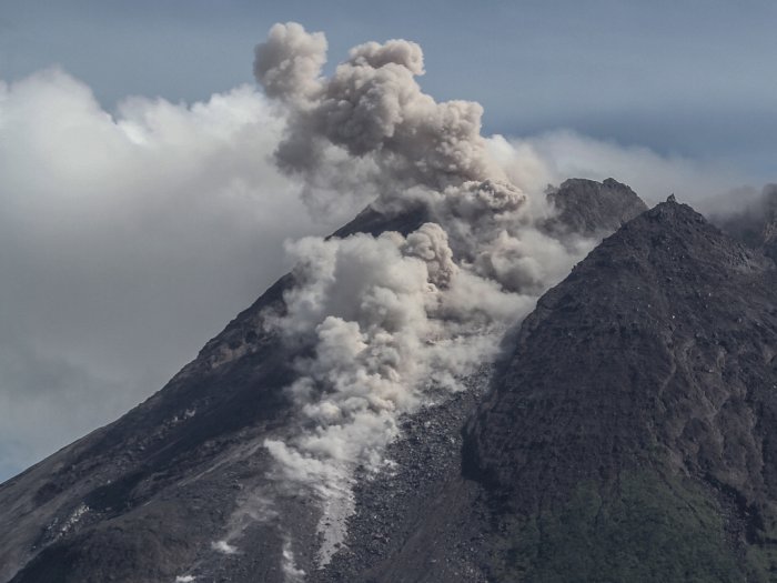
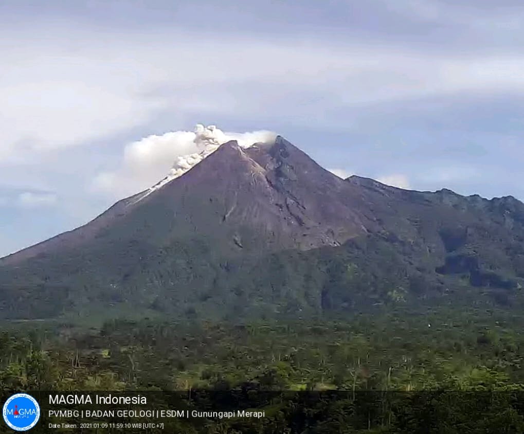
The weather around Mount Merapi is generally sunny in the morning, while the afternoon until evening is foggy. The smoke emitted from the crater is white, thin to thick with low pressure. A maximum smoke height of 800 m is observed from the Mount Merapi observation post in Selo on January 7, 2021 at 6:40 a.m.
On January 4, 2021 at 7:50 p.m., a first eruption of incandescent lava was observed, which was recorded on a seismogram with an amplitude of 33 mm and a duration of 60 seconds. The sound of avalanches was heard as far as the Mount Merapi observation post in Babadan. During this week, avalanches of incandescent lava were observed 19 times with a maximum slide distance of 800 meters to the upper reaches of the Kali Krasak. Then on January 7, 2021, 4 hot clouds started to occur, namely at 08.02, 12.50, 13:15 and 14.02. The sliding distance of hot avalanches is estimated to be less than 1 km to the upper reaches of the Kali Krasak.
The morphological analysis of the peak area based on photos of the southwest sector of January 7, 2021 compared to that of December 24, 2020 shows a change in the morphology of the peak area due to avalanche activity and the presence of a new lava dome.
Seismicity
This week, the seismicity of Mount Merapi recorded
4 hot cloud avalanches (AP),
541 shallow volcanic earthquakes (VTB),
2270 multi-phase earthquakes (MP),
4 low frequency earthquakes (LF),
611 avalanche earthquakes (RF),
628 emission earthquakes (DG)
4 tectonic earthquakes (TT).
The seismic intensity this week is higher than last week.
Deformation
The deformation of Mount Merapi which was monitored using EDM this week showed a shortening rate of 15cm / day.
Rain and lahars
This week there was rain at Mount Merapi Observation Post with the highest rainfall intensity of 46mm / hour for 75 minutes at Kaliurang Post on January 6, 2021 and it was reported that there was had an increase in the flow of the Boyong River.
Conclusion
Based on the results of visual and instrumental observations, it is concluded that:
The volcanic activity of Mount Merapi is still quite high, so the activity status is still at the “SIAGA” level.
Current potential dangers come in the form of lava avalanches, ejection of volcanic material in the event of an explosive eruption and up to 5 km distance of hot cloud slides.
Source : BPPTKG.
Photos : Hendra Nurdiyansyah
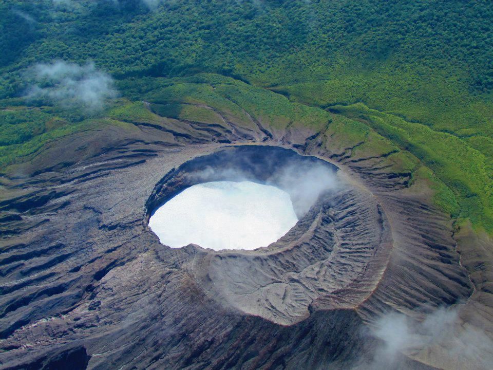
Costa Rica , Turrialba / Poas / Rincon de la Vieja :
Turrialba volcano
Lat: 10.025 ° N; Long: 83.767 ° W;
Height: 3340 m.s.n.m.
Current activity level: 2 (active volcano)
Potentially associated hazards: gas, ash emission, proximal ballistic projections
No ash emission was observed. There has been a slight increase in the number of LPs type events and particularly high frequencies. The number of LPs type events followed by short tremors is maintained. A « Tornillo » type event was recorded on December 28 after the characteristic tremor of an eruption or an expiration, but there was no direct observation to confirm due to bad weather conditions. The virtual absence of an infrasound signal suggests a profound event. Geodetic measurements show the deflation of the Turrialba-Irazú massif. The contraction remains stable. There is no significant change in the H2S / SO2 and CO2 / SO2 ratios, which remain stable, with average values around 0.3 and 20 respectively. No thermal anomaly was detected by the MODIS analysis.
Poas volcano
Lat: 10.2 ° N; Long: 84.233 ° W;
Height: 2780 m.s.n.m.
Current activity level: 2 (active volcano)
Potentially associated hazards: gas, phreatic eruptions, proximal ballistic projections.
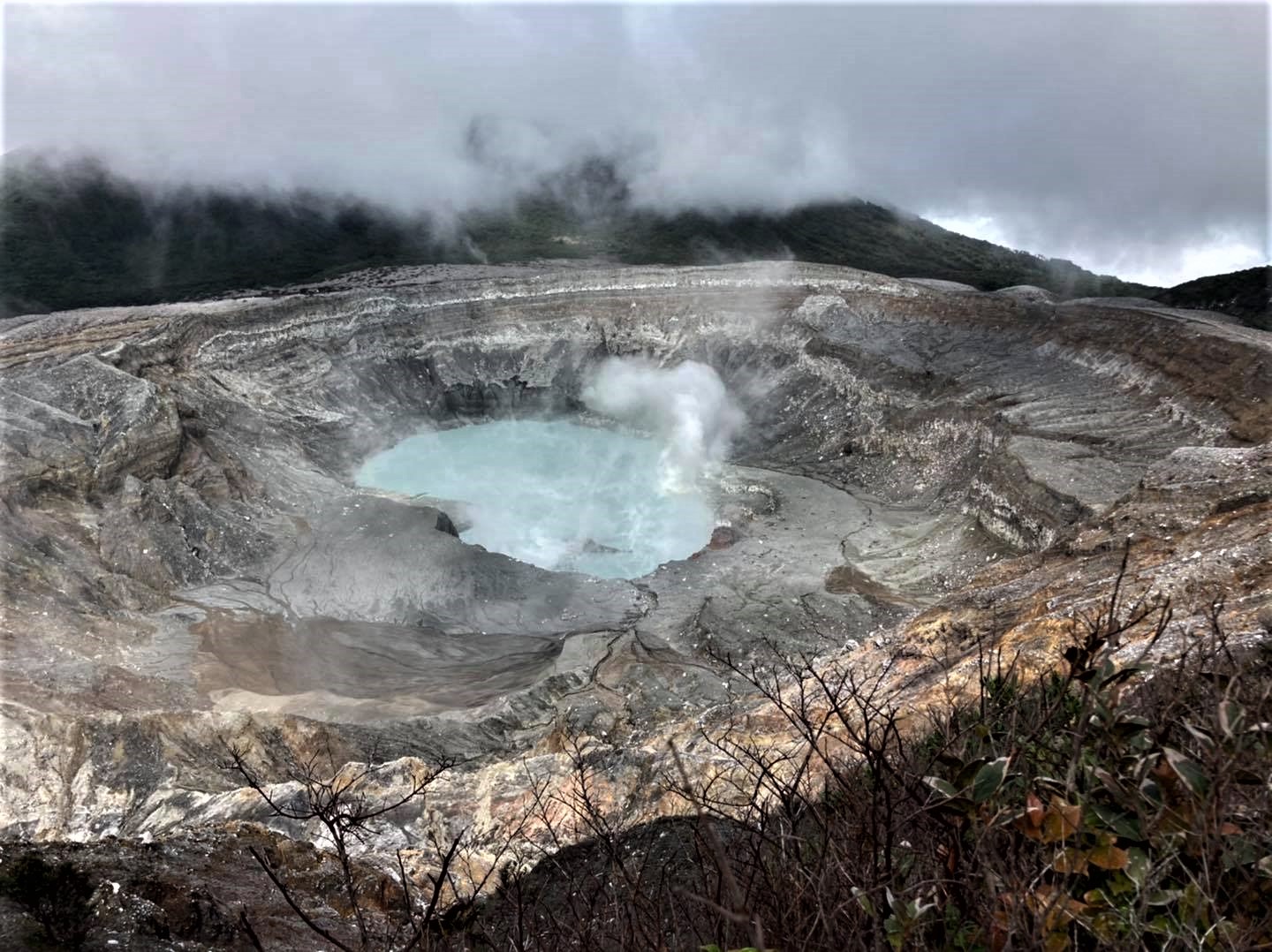
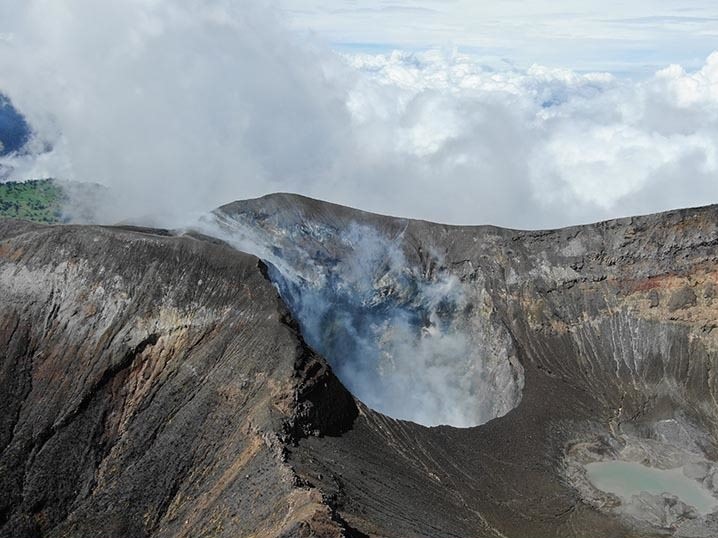
No éruption was detected. The seismic activity shows an increase in the RSEM level since December 13. A small extension of the volcano has been observed since early December. The H2S / SO2 ratio has declined since November (from 0.3 in November to ~ 0.08 this week), but the SO2 / CO2 ratio remains low (~ 0.6) except for a peak (until to 1.7) in mid-December. SO2 flux increased at the beginning of December and decreased after December 10. The level of the lake increased a little at the end of December to reach its highest level since the magmatic crisis of 2017. On December 13, a proximal thermal anomaly of similar amplitude to that of November 26, 2020 was detected, by MODIS analysis. A fumarole appeared in mid-December in the northeast of the lake, corresponding to a reactivation of the orange fumarole visible in 2006, possibly due to the increase in hydrostatic pressure due to the high level of the lake. An increase in the activity of the convective cell corresponding to the underwater C Mouth is also observed.
Rincon de la Vieja volcano
Lat: 10.83 ° N; Long: 85.324 ° W;
Height: 1895 m.s.n.m.
Current activity level: 3 (erupting volcano)
Potentially associated hazards: gas, phreatic eruptions, proximal ballistic projections, lahars.
The occurrence of eruptions stopped after the deep eruption of December 13, but a significant tremor appeared. At the end of December, a maximum was perhaps observed in the frequency of « Tornillo » type events, which, if confirmed, could again suggest the occurrence of eruptions. In addition, TT type events were recorded in the southern zone of the volcano without knowing whether they are natural or induced by geothermal exploitation. Geodetic monitoring recorded a significant change in the direction of the motion vectors in late November and early December, still with extension, suggesting a possible small intrusion. No thermal anomaly was detected by the MODIS analysis. Oxidation parameters (ORP) and electrical conductivity in the Santuario Ojo (hot spring north of the volcano) have stabilized at “normal” values.
Source : Ovsicori .
Photos : G. Avard / Ovsicori , RSN , Raul Mora / RSN / UCR .
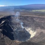
Hawaii , Kilauea :
19°25’16 » N 155°17’13 » W,
Summit Elevation 4091 ft (1247 m)
Current Volcano Alert Level: WATCH
Current Aviation Color Code: ORANGE
Activity Summary:
Lava activity is confined to Halemaʻumaʻu with lava erupting from vents on the northwest side of the crater. Wednesday afternoon (Jan. 6), the lava lake was 194 m (636 ft) deep and perched 1-2 m (1-2 yds) above its edge. SO2 emission rates were still elevated.
Summit Observations:
Summit tiltmeters recorded weak deflationary tilt since Jan. 1 with a brief, but temporary, steepening of the deflationary trend overnight between Jan. 6 and 7. Seismicity remained elevated but stable, with steady elevated tremor and a few minor earthquakes.
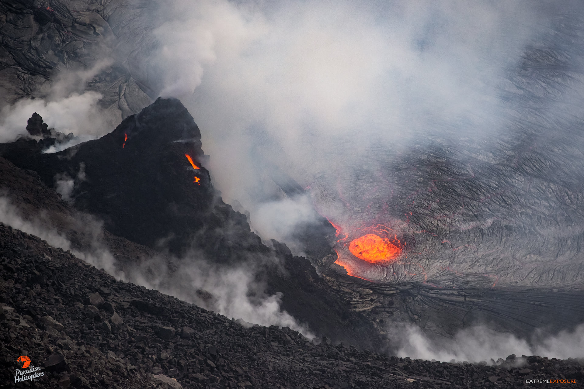
image, taken during the overflight on Tuesday morning, of the west vent effusing lava into Halema‘uma‘u’s perched lake. A spatter cone has built up over the top portion of the vent on the steep western wall, and feeds the lava lake through crusted tubes. A submerged portion of the vent is also discharging lava, creating a glowing dome-shaped fountain on the lake’s surface. HVO geologists estimated its height to be roughly 16 feet. While we hovered above, it fluctuated a bit, even disappearing for a moment before resuming for the remainder of the overflight. HVO’s update this morning says that the dome fountain weakened further yesterday. And, getting back to the fuming, sulfur dioxide emissions are estimated to be 3,400 tons per day
East Rift Zone Observations:
SO2 and H2S emissions from Puʻu ʻŌʻō were below instrumental detection levels when measured yesterday (Jan. 7).
Halemaʻumaʻu lava lake Observations:
The west vents spattered from the top of a small cone plastered on the northwest wall of Halemaʻumaʻu crater. The dome fountain weakened yesterday morning forcing lava to flow out of the formerly spattering vents on the northwest crater wall and into the lake for several hours yesterday. This morning, lava was flowing from the west vents through a crusted channel into the lake and there may be a small dome fountain merged with the outflow from this channel.
Source : HVO .
Photo : Bruce Omori .


No comment yet, add your voice below!