
December 31 , 2020.
Italy , Stromboli :
Weekly Bulletin December 21, 2020 to December 27, 2020 (issue date December 29, 2020)
SUMMARY OF THE ACTIVITY BULLETIN
In the light of surveillance data, it is highlighted:
1) VOLCANOLOGICAL OBSERVATIONS: Explosive volcanic activity of Strombolian type at low level (4 to 3 events / h) and with a low intensity of explosions in the areas of the North and Center-South crater
2) SEISMOLOGY: The seismological parameters do not show significant variations.
3) DEFORMATIONS: No significant change recorded by tilt and GNSS networks
4) GEOCHEMISTRY: SO2 flux: medium level
C / S Ratio – There is no updated data: the latest values available (6-12-2020) are on average levels (C / S = 12.1).
The isotopic ratio of Helium is at high values (R / Ra = 4.4, sampling of December 21).
5) SATELLITE OBSERVATIONS: The thermal activity in the summit area is at a low level.
VOLCANOLOGICAL OBSERVATIONS
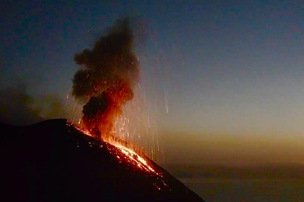
In the period under observation, the eruptive activity of Stromboli was characterized by the analysis of the images recorded by the surveillance cameras INGV-OE located at 190 m, Punta Corvi and 400 m.
In the area of the North crater, the N1 and N2 craters, both characterized by two emission points, produced low intensity explosions (less than 80 m high) emitting fine material (ash) mixed with coarse material (lapilli and bombs). The average frequency of explosions varied between 1/2 and 2/5 events / h. In the Center-South zone, the explosions emitted mainly fine materials, with a low intensity and with a frequency between 1 and 3 to 6 events / h.
Overall, the total average frequency of explosions during the week was 4.3 events / hr, ranging from a low to a maximum of 2.0 and 5.3 events / h, respectively.
The amplitude of the volcanic tremor showed generally low values on December 20, 21 and 22, then it reached medium-low values.
Source : INGV.
Photo : Webcam
Hawaii , Kilauea :
19°25’16 » N 155°17’13 » W,
Summit Elevation 4091 ft (1247 m)
Current Volcano Alert Level: WATCH
Current Aviation Color Code: ORANGE
Activity Summary:
Lava activity is confined to Halemaʻumaʻu with lava erupting from vents on the northwest side of the crater. As of 3:45 am this morning (Dec. 30), the lava lake was 181 m (593 ft) deep with a narrow black ledge around it. Reduced, but still elevated, SO2 emissions were measured Monday (Dec. 28).
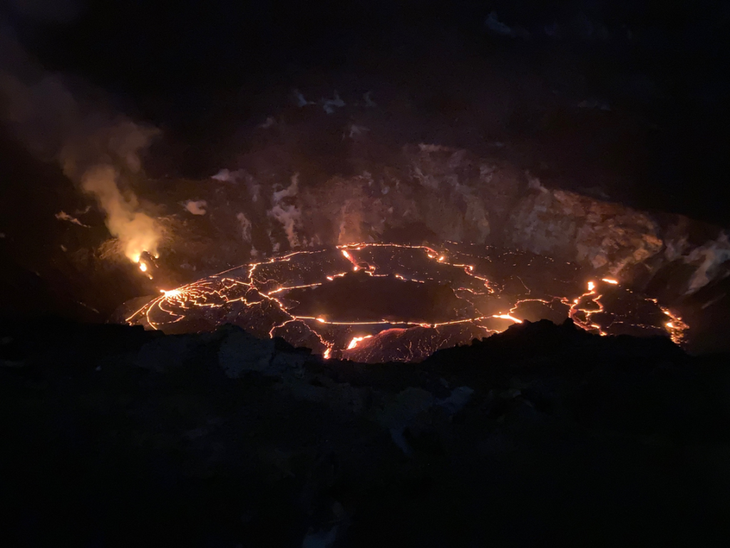
Overnight, the eruption in Halema‘uma‘u at Kīlauea’s summit continued. At about 3:45 a.m. HST this morning (Dec. 30), HVO field crews measured the lava lake as 181 m (593 ft) deep with a narrow black ledge around it. This photo, taken at around 2 a.m. HST December 30, shows that lava continues to flow from the west vents into the lava lake. Reduced, but still elevated, SO2 emissions were measured at Kīlauea’s summit on Monday (Dec. 28), with rates of about 3,300 tonnes/day.
Summit Observations:
Preliminary analysis of sulfur dioxide emission rates measured Monday (Dec. 28) show that the rates are about 3,300 tonnes/day– slightly lower than the Dec. 27 rate of 5,500 t/d, but still elevated; both values were in the range of emission rates common for the pre-2018 lava lake. Summit tiltmeters continued to record weak inflationary tilt starting on Monday (Dec. 26). Seismicity remained elevated but stable, with steady elevated tremor and a few minor earthquakes.
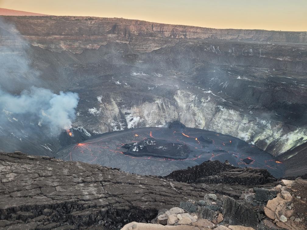
The lava lake within Halemaʻumaʻu crater has changed little in the past few days.The most recent thermal map (Dec. 28) provided the lake dimensions as 770 by 490 m (840 by 535 yds) for a total area of 29 ha (72 acres). Over the past day, the main island of cooler, solidified lava floating in the lava lake (the raised mass visible in the center of the photo) drifted slightly to the west (left in the photo) in the lake and rotated counter-clockwise, whereas the 10 or so much smaller islands to the east (raised masses to the right of the island in the photo) remained stationary. The main island measured about 250 m (820 ft) in length, 135 m (440 ft) in width, and about 3 ha (7 acres) in area based on the Dec. 28 thermal map. Measurements on Dec. 27 show that the island surface was about 6 m (20 ft) above the lake surface.
East Rift Zone Observations:
Geodetic monitors indicate that the upper portion of the East Rift Zone (between the summit and Puʻu ʻŌʻō) contracted while the summit deflated. There is no seismic or deformation data to indicate that magma is moving into either of Kīlauea’s rift zones.
Halemaʻumaʻu lava lake Observations:
The west vents spattered while erupting lava flowed through crusted-over channels into a lava lake within Halemaʻumaʻu crater.
The lava lake within Halemaʻumaʻu crater has changed little in the past few days and was about 181 m (593 ft) deep as of early this morning (Dec. 30). The lake volume was about 23 million cubic meters (30 million cubic yards or 5.2 billion gallons). The most recent thermal map (Dec. 28) provided the lake dimensions as 770 by 490 m (840 by 535 yds) for a total area of 29 ha (72 acres). The narrow (10-30 m or 11-22 yd) ledge around the lake was about 1-2 m (1-2 yds) above the active lake surface
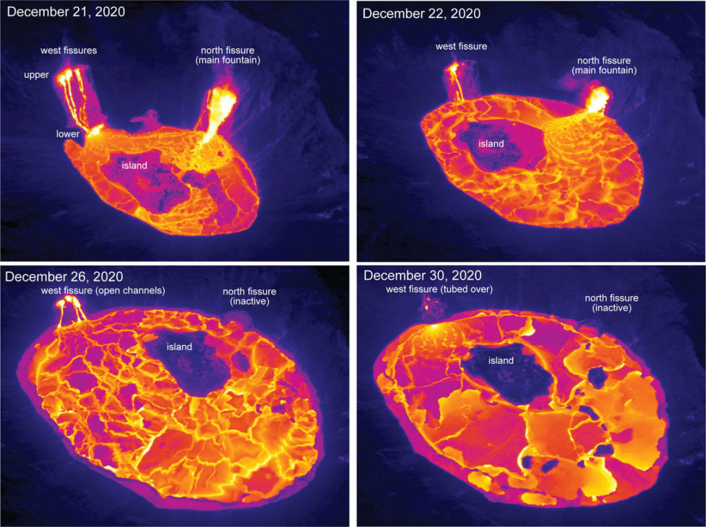
These aerial thermal images of Kīlauea Volcano’s summit compare the changes within Halema‘uma‘u crater over the course of this summit eruption. The first image (upper left) was taken on December 21, the morning after the eruption started, with the north and west fissure vents feeding the lava lake and the middle fissure inactive. The depth of the lava lake was approximately 88 m (289 ft). By the next morning, December 22, (upper right) the lava lake depth increased to about 134 m (440 ft) and had drowned the inactive middle fissure. In the December 26 image (lower left), the north fissure is inactive and only the west fissure vents are feeding lava into the lava lake, which was at a depth of about 176 m (577 ft) that morning. During today’s overflight (lower right), the lava lake was approximately 182 m (597 ft) deep, and lava flowing into the lake was crusted over. Note the change in position over time of the island within the lava lake.
Over the past day, the main island of cooler, solidified lava floating in the lava lake drifted slightly to the west in the lake and rotated counter-clockwise. The 10 or so much smaller islands to the east remained stationary. The main island measured about 250 m (820 ft) in length, 135 m (440 ft) in width, and about 3 ha (7 acres) in area based on the Dec. 28 thermal map. Measurements on Dec. 27 show that the island surface was about 6 m (20 ft) above the lake surface.
Source : HVO
Photos : USGS photo by H. Dietterich. USGS photo by N. Deligne. , M. Patrick.
Saint-Vincent-and-the-Grenadines , Soufrière Saint Vincent :
LA SOUFRIERE BULLETIN, DECEMBER 30, 2020 6.00 PM
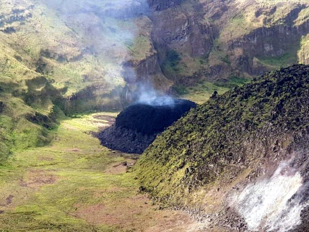
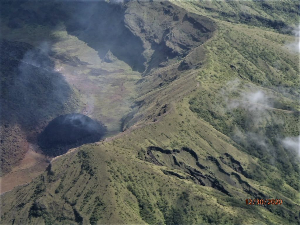
An Aerial reconnaissance conducted today Wednesday, December 30 indicates that there are no significant changes at the La Soufriere Volcano since Tuesday, December 29th, 2020. Magma continues to ooze to the surface and the dome has increased in size.
The Executive Committee of the National Emergency Management Organisation (NEMO), which comprises Technical Officers from the various
Government Departments, Private Sector and Non- Governmental Organizations met today at NEMO’s Conference Room to activate plans, in the event that the level of seismicity increases and evacuation becomes necessary.
The Caribbean Disaster Emergency Management Agency (CDEMA) has activated the Regional Coordination Plan as per the protocol which corresponds to the Orange Volcano Hazard Alert Level.
A group of Scientists from the Seismic Research Centre, University of the West Indies St. Augustine Campus led by Vincentian Professor Richard Robertson will arrive in St. Vincent and the Grenadines on Thursday 31st December, 2020 on board the Regional Security System (RSS) Aircraft. The Scientists will install instruments to strengthen the monitoring mechanism System, so that more accurate and timelier scientific advisory on the activities at the La Soufriere Volcano can be provided.
Alert level remains at Orange. Persons living in areas close to the volcano which include communities from Fancy to Georgetown and Belle Isle to Richmond are asked to remain alert and listen to all advisories from the National Emergency Management Organisation (NEMO).
The National Emergency Management Organisation is once again reminding the public that no evacuation order or notice has been given.
NEMO is also appealing to the public to desist from visiting the La Soufriere Volcano until the scientists advise that it is safe to do so.
The University of the West Indies Seismic Research Centre (UWI-SRC) stated in a press briefing that seismicity at the volcano began to increase in early November and changes in the water lake and fumarolic area were noted on 16 December. A persistent thermal anomaly had been identified in satellite data over the previous couple of days, which is what prompted the NEMO field visit.
Japan , Shinmoedake :


No comment yet, add your voice below!