
November 17 , 2020.
Italy , Stromboli :
STROMBOLI PRESS RELEASE [UPDATE n. 2], November 16, 2020 10:53 (09:53 UTC).
The National Institute of Geophysics and Volcanology, Osservatorio Etneo reports that at 09:17:50 UTC through surveillance cameras, an explosion of greater intensity was observed in the Center-South zone. The products emitted fell abundantly along the Sciara del Fuoco.
From the seismic point of view, the phenomenon, clearly visible at all the seismic stations of Stromboli, was characterized by a sequence of explosive events and landslides which started at 9:17 (UTC) for a duration of 4 minutes. Regarding the amplitude of the volcanic tremor, no significant variation is reported.
Further updates will be communicated promptly and in any event within 3 hours of this press release.
STROMBOLI PRESS RELEASE [UPDATE n. 3] 16 November 2020 12:03
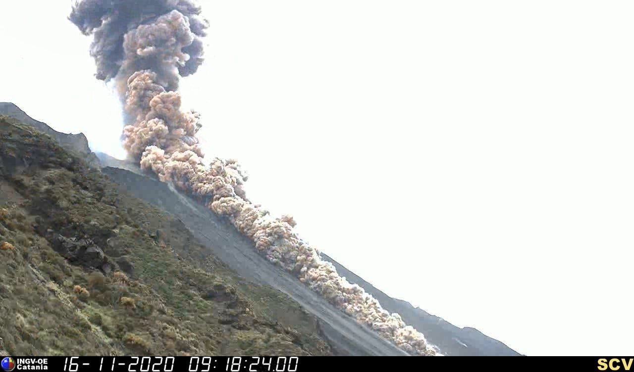
The National Institute of Geophysics and Volcanology, Osservatorio Etneo, announces that the explosive event which took place at 09:17:50 UTC, in the Center-South area of the terrace of the Stromboli crater, was of greater intensity.
It produced a dense cloud of ash about 1 km high above the top of the volcano, and a pyroclastic flow that spilled along the Sciara del Fuoco rapidly reaching the coast line, extending over the sea surface for about 200 m.
After this event, which lasted a few minutes, the volcano’s normal explosive activity continued.
Seismically, signals at the Stromboli seismic stations show a sequence of explosive events that begins at 9:17:10 UTC (the most significant at 9:17:48 UTC) and has a duration of one just over 4 minutes. The explosions were also accompanied by seismic signals attributable to landslides.
Regarding the amplitude of the volcanic tremor, no significant variation is reported.
From the data from the inclinometers of Timpone del Fuoco, an anomaly of 0.05 µrad can be observed due to the major explosion at 9.17 UTC.
The signals from the GPS network show no significant variation.
Further updates will be communicated shortly.
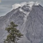
Two major explosions in Stromboli, November 10 and 16, 2020, November 16, 2020
In recent days, Stromboli has been rather « agitated », generating two eruptive events that can be qualified as major explosions.
The first event took place at 9:04 p.m. local time on November 10, 2020 and affected the Center-South area of the crater terrace. The event lasted about 6 minutes and produced a vertical eruptive column. The erupting products were mainly dispersed along the Sciara del Fuoco, causing widespread lamination of the pyroclastic products.
The phenomenon developed by generating at least three other explosions of less intensity than the largest one and ended at 9:10 p.m. the same day.
From the seismic point of view, the phenomenon, clearly visible on all the seismic stations of Stromboli, was characterized by a sequence of low frequency events that began at 9:03 p.m. on November 10, 2020, with an amplitude of the volcanic tremor without significant variations ( Figure 1). At 11:11 p.m., all monitored parameters returned to normal activity.

Figure 1 – Seismograms recorded by the “IST3” seismic station of the INGV-Etneo Observatory, of the two major explosions of November 10, 2020 (left) and November 16, 2020 (right). You can see the thicker and longer tail in the latter’s seismogram, which is the effect of the landslide of material involved in pyroclastic flow on the Sciara del Fuoco.
After a few days, today November 16, at 10:17 a.m. (local time) a new major explosion was observed, still generated in the crater terrace. The products emitted fell back in abundance along the Sciara del Fuoco, while for a few minutes ash and lapilli fell on the town of Stromboli, in the locality of Scari. The event produced a dense cloud of ash in about a kilometer high above the top of the volcano, and a pyroclastic current that flowed along the Sciara del Fuoco, quickly reaching the coast and extending to the surface of the sea for about 200 meters. From a seismic point of view, the phenomenon was clearly visible on all the seismic stations of Stromboli and was characterized by a sequence of explosive events and landslides which started at 10:17, for a duration of 4 minutes ( figure 1). Regarding the extent of volcanic tremor, no significant change has been reported. At 2:10 p.m., all monitored parameters returned to normal activity.
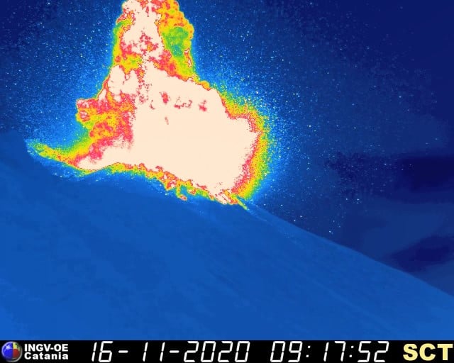
Images taken by thermal (SCT) and visual (SCV) surveillance cameras show the start of the explosion and the flow of hot material on the Sciara del Fuoco. We also note how, in the seconds preceding the start of the explosion, a small vent (hornito) placed immediately under the rim of the crater increased its activity (figure 2).

Figure 2 – Comparison between the images recorded by the thermal camera « SCT » on the north side of the Sciara del Fuoco before and after the explosion of November 16, 2020. We note the disappearance of a piece of the edge of the crater in correspondence with the hornito which had grown a few seconds before the explosion.
Events of this type are not uncommon and are part of the volcano’s normal activity. The largest explosions are produced from the mouths of the crater terrace and are characterized by greater energy and frequency of ordinary activity, and greater volumes of magma emitted. They can occur at often irregular intervals. They frequently cause the relapse of volcanic bombs, lapilli and rock fragments, even quite large, in the top part of the volcano, but, compared to normal activity, at greater distances from the eruptive vent. Consequently, both the viewpoint of Pizzo sopra la Fossa and part of the paths that lead to it can be affected by these fallout of volcanic materials.
Source : INGV.
Photos et vidéo : INGV.
Guatemala , Santiaguito :
SPECIAL VOLCANOLOGICAL BULLETIN, November 16, 2020, 9:12 a.m. local time
Activity type: Pelean
Morphology: Complex of dacitic domes
Geographical location: 14 ° 44 ’33 ˝ Latitude N; 91 ° 34’13˝ Longitude W.
Height: 2500 m.
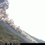
EXPLOSION WITH PYROCLASTIC FLOWS
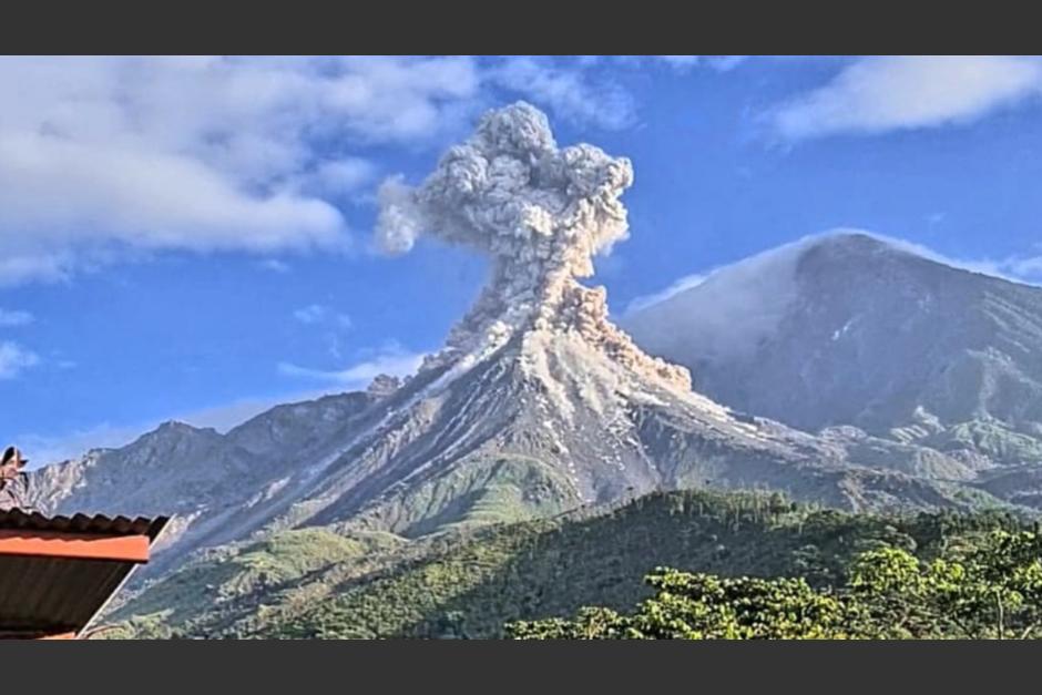
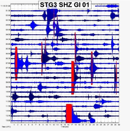
The volcanological observatory of the volcanic complex of Santa María Santiaguito reports a moderate explosion event that caused the emission of an ash column at a height of 3600 meters above sea level and the descent of pyroclastic flows along the flanks of the Caliente dome. This event was recorded at seismic stations STG3 and STG8 around 7.15 a.m. (local time). The longest pyroclastic flow descended in the upper part of the bed of the San Isidro river, on the southwest flank of the dome, without reaching the populated places or causing damage. The wind moved the ash cloud in a southwest direction, towards the areas of San Marcos Palajunoj and its surroundings.
This type of event is due to the unstable accumulation of lava blocks and fine pyroclasts on the Caliente Dome, causing their detachment and channeling in the form of avalanches and pyroclastic flows. This type of explosive event can be repeated over the following hours and days, as it is part of the Vulcanian and Pelean type activity that characterizes this complex of domes.
INSIVUMEH provides visual and instrumental surveillance thanks to its observers and stations STG3 and STG8, which record the seismic activity generated in the volcanic complex of Santa María-Santiaguito.
Source : Insivumeh.
Photo : Conred.
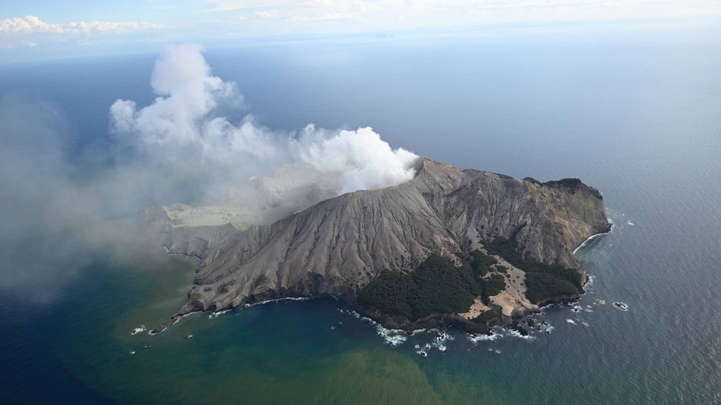
New Zealand , White Island :
Ash emission continues at Whakaari/White Island. Volcanic Alert Level remains at Level 2.
Published: Tue Nov 17 2020 11:00 AM
Observations made yesterday confirm that Whakaari/White Island continues to emit volcanic ash with the steam and gas plume. The amounts of CO2 and SO2 gas have decreased. The Volcanic Alert Level remains at Level 2.
Last Wednesday (11th November 2020), a period of ash emission began at Whakaari/White Island. Ash deposits were observed on some of the island’s cameras, and at times, a darker than usual plume was reported from the mainland. Satellite images provided at that time by MetService, courtesy of the Japan Meteorological Agency, confirmed the ash emission, but later images showed little or no apparent ash.
Gas-measuring and observation flights on Monday 16th November 2020 still reported small amounts of ash in the plume (see image below). Overall, observations indicate a lower level of ash emission over the past few days.

Laboratory analyses of the ash shows it comprises hydrothermal minerals and old volcanic material (ash sediment), and that no new magma is present. The ash particles are material eroded from the 2019 vent area by the flow of steam and gas. Since Wednesday 11th November 2020, ash coating on some of the web camera windows has made it difficult to view the active vent area, and ash deposited on solar panels has reduced their capability to charge some of our monitoring stations.
The amounts of CO2 (Carbon dioxide) and SO2 (Sulphur dioxide) volcanic gases carried in the plume continue to be elevated above background levels but are now slightly lower than last week’s measurements. On Monday 16th November 2020, CO2 emission was 1937 tonnes/day, and SO2 was 710 tonnes/day. Previously (Thursday 12th November 2020), CO2 emission was 2390 tonnes/day, and SO2 was 618 tonnes/day.
During fine weather conditions, plumes of gas, steam, and possibly ash will be seen rising above the island and trailing off downwind. Should any explosive activity produce a significant ash cloud, the likelihood of ash affecting the mainland remains very low. From last week’s ash emission, there has been no reported impact beyond Whakaari/White Island. In favourable wind conditions, the current plume may be noticed on the mainland as weak acid rain.
During the past week, a sequence of small earthquakes and a larger than normal volcanic earthquake were located close to the volcano. Low-level volcanic tremor continues. This varied seismic activity is not unusual for Whakaari/White Island.
The elevated volcanic gas emission combined with the increased seismic activity confirm that Whakaari/White Island is in a period of heightened unrest. As a result, the Volcanic Alert Level remains at Level 2 and the Aviation Colour Code remains at Yellow.
The Volcanic Alert Level reflects the current level of volcanic unrest or activity and is not a forecast of future activity.
GNS Science and our National Geohazards Monitoring Centre continuously monitor Whakaari/White Island for changes in activity. Further updates will be provided as needed.
Source : Geonet / Mike Rosenberg , Duty Volcanologist.
Photos : Geonet , Rotorua Daily Post.
Peru , Sabancaya :
Analysis period: November 9 to 15, 2020, Arequipa, November 16, 2020.
Alert level: ORANGE
The Geophysical Institute of Peru (IGP) reports that the eruptive activity of the Sabancaya volcano remains at moderate levels, that is, with the continuous recording of explosions with columns of ash and gas up to 3.3 km altitude above the summit of the volcano and their subsequent dispersion. Therefore, for the following days, no significant change is expected in the eruptive activity.
The IGP recorded and analyzed the occurrence of 2,264 earthquakes of volcanic origin, associated with the circulation of magmatic fluids inside the Sabancaya volcano. An average of 54 explosions were recorded daily of low to medium intensity. During this period, Volcano-Tectonic (VT) earthquakes were located mainly in the North-East of Sabancaya and presented magnitudes between M2.4 and M3.7. The most representative earthquake (M3.7) was recorded on November 12 at 12:55 p.m., 15 km northeast of Sabancaya and 15 km deep.

The monitoring of the deformation of the volcanic structure using GNSS techniques (processed with fast orbits) does not present any significant anomalies. However, in general, an inflation process has been observed in the south-eastern sector of Sabancaya and in the north sector (Hualca Hualca volcano). Visual surveillance identified columns of gas and ash up to 3.3 km altitude above the summit of the volcano, which were scattered to the northwest, north, and northeast of Sabancaya. Satellite monitoring identified the presence of 11 thermal anomalies with values between 3 MW and 63 MW, associated with the presence of a lava body on the surface of the volcano’s crater.
RECOMMENDATIONS
• Keep the volcanic alert level in orange.
• Do not approach within a radius of less than 12 km from the crater.
Source : IGP.
Photo : Andina .


No comment yet, add your voice below!