
August 03 , 2020.
Alaska , Makushin :
53°53’24 » N 166°55’30 » W,
Summit Elevation 5906 ft (1800 m)
Current Volcano Alert Level: ADVISORY
Current Aviation Color Code: YELLOW
A sequence of small earthquakes centered southeast of the summit that began on June 15 continues. Satellite and web camera views were obscured by clouds over the past day.

The earthquake sequence may be associated with volcanic unrest, but there have been no signs of deformation or surface activity noted in other monitoring data. It is likely that we would see additional signs of unrest prior to an eruption, should it occur. The volcano is monitored with a network of seismic and GPS instruments, a web camera, satellite data, and regional infrasound and lightning detection instruments.
If an eruption were to occur, the main hazard would likely be from airborne ash and ash fall.
Source : AVO.
Photo : Swangel, Travis ( 2017 ).
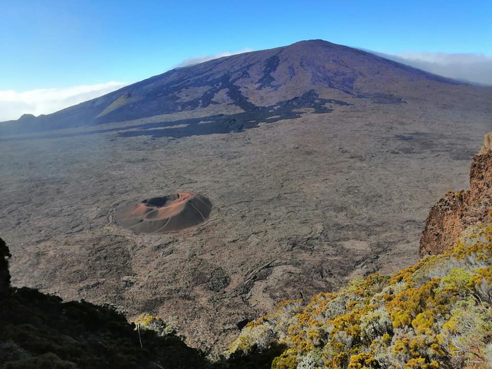
La Réunion , Piton de la Fournaise :
Seismicity
In July 2020, the OVPF recorded at Piton de La Fournaise:
• 224 shallow volcano-tectonic earthquakes (0 to 2.5 km depth) below the summit craters;
• 2 deep earthquakes (2.5-5 km depth);
• 247 rockfalls (inside the Cratère Dolomieu or along the cliff of the Enclos Fouqué caldera and the Rivière de l’Est rempart).
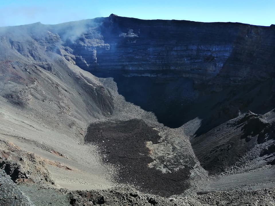
The volcano-tectonic activity under the summit of Piton de la Fournaise in July 2020 was mainly marked by the seismic crisis of July 3 (197 superficial volcano-tectonic earthquakes between 3:20 and 3:55 UT). These earthquakes were located under the southern part of the Dolomieu crater between 1.7 and 2.2 km deep, and were associated with a magma intrusion which started from the superficial magmatic reservoir and which stopped at depth before reach the surface.
Following the magmatic intrusion of July 3, summit volcano-tectonic activity remained low with on average less than one shallow volcano-tectonic earthquake per day.
It should be noted that the OVPF again recorded numerous (210) collapses in the area of the broken East River in July 2020.
Deformation:
The inflation (swelling) of the edifice which had resumed around June 16 continued until around July 13. Thus, between June 16 and July 13 an elongation of about 3 cm max. of the summit area and an elongation of approximately 3.75 cm max. of the base of the terminal cone were recorded. The numerical modelizations of these strains show during
during this period, the activation of a pressure source around 1-1.5 km deep under the Dolomieu crater, corresponding to the pressurization of the superficial magmatic reservoir.
The deformations related to the July 3 magmatic intrusion were of very low intensity (less than 0.5 cm) and were only visible on the data from the inclinometric stations (with a maximum slope variation of 4 µradians). …/…
Results :
The resumption of seismicity and inflation since June 16, as well as the high fluxes of CO2 in the soil (despite a decreasing trend) witnessed a resumption of the pressurization of the superficial magmatic reservoir and its recharge by deep magmas, which triggered the July 3 intrusion.
Since the July 3 intrusion, seismic activity has remained low and inflation came to a halt around July 13.
It should be noted that since 2016, the recharge of the superficial magmatic reservoir under the Piton de la Fournaise has been carried out by pulses, so such phases of lull in deformations and seismicity have already been observed on several occasions between 2016 and 2020 over periods ranging from about 15 to 80 days, and eruptions can be triggered after only a short period of restarting the shallow reservoir recharge.
Source : OVPF .
Read the full article : http://www.ipgp.fr/sites/default/files/ovpf_20200803_bullmensu_0.pdf
Photos : Nath Duverlie
Nicaragua , Télica :
Yesterday, Sunday, the authorities presented a report containing the incidents of the last hours in Nicaragua.
TELICA VOLCANO SURVEILLANCE ACTIVITY
Between 1:22 p.m. yesterday and – 6:44 a.m. today, 25 new degassing episodes were recorded; the largest reached a height of 100 above the crater.
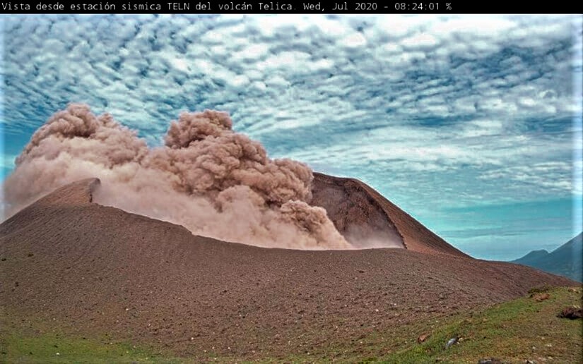
In three of the cases, there were small expulsions of ashes, which fell near the community of Aguas Frías, without causing damage.
We maintain communication with the COMUPRED of the municipality of Telica, which continues to monitor the situation.
Source : el19digital.com.
United States , Yellowstone :
44°25’48 » N 110°40’12 » W,
Summit Elevation 9203 ft (2805 m)
Current Volcano Alert Level: NORMAL
Current Aviation Color Code: GREEN
Recent work and news
In July, field work in Yellowstone National Park continued. Operations included the deployment of two additional semi-permanent GPS stations (which will be removed in the fall before the onset of winter), the installation and maintenance of river-monitoring stations, and maintenance on the Yellowstone Seismic Network and Norris temperature-monitoring network.
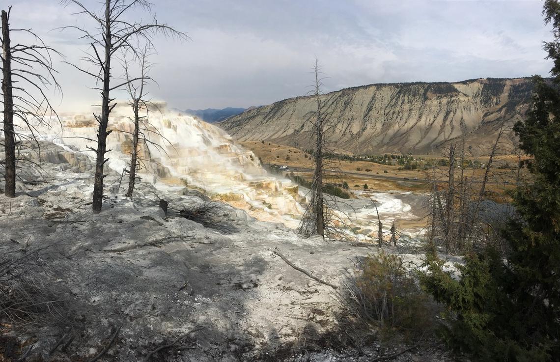
Angel Terrace, Mammoth Hot Springs, Yellowstone National Park. Travertine deposits are abundant in the area.
To the delight of park visitors, Steamboat Geyser continued its trend of frequent activity with six water eruptions in the past month: July 3, 9, 13, 19, 24, and 30. This brings the total number of eruptions for the year to 29.
Seismicity :
During July 2020, the University of Utah Seismograph Stations, responsible for the operation and analysis of the Yellowstone Seismic Network, located 47 earthquakes in the Yellowstone National Park region. The largest event was a minor earthquake of magnitude 1.7 located 12 miles north-northwest of Pahaska Tepee, WY, on July 3 at 11:56 PM MDT.
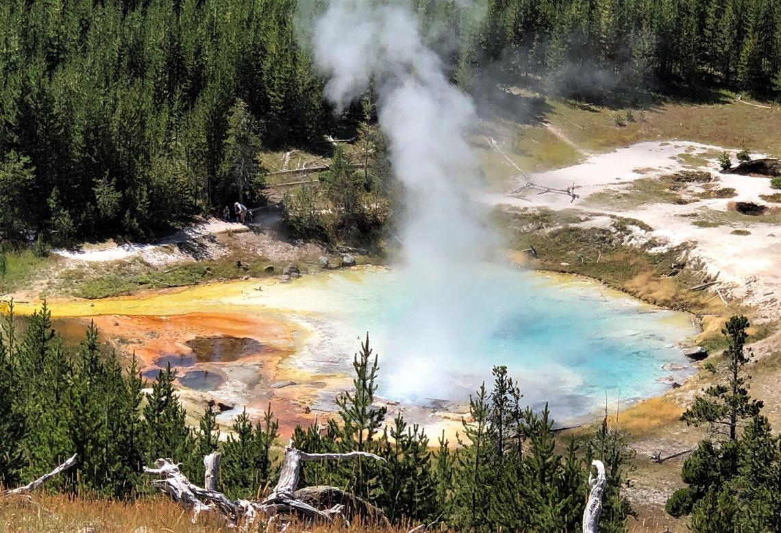
Imperial Geyser hot spring pool in Yellowstone National Park is about 30 m (about 100 ft) across and contains alkaline-Cl waters with a steam vent in the pool and mudpots outside the pool area (in the upper right part of this photo). USGS Photo by Pat Shanks, 2019.
No swarm seismicity was observed in July.
Yellowstone earthquake activity remains at background levels.
Ground deformation
The overall deformation style and rate at Yellowstone remains largely unchanged over the past several months. Subsidence of Yellowstone caldera, which has been ongoing since 2015, continued at an average rate of 2-3 cm (about 1 in) per year. In the area of Norris Geyser Basin, little deformation has been detected by a nearby GPS station since the start of 2020.
Source : YVO / USGS.
Photos : JoAnn Holloway. Pat Shanks. Public domain.


No comment yet, add your voice below!