
July , 29 , 2020.
Italy / Sicily , Etna :
Weekly bulletin from July 20, 2020 to July 26, 2020, (issue date July 28, 2020)
SUMMARY OF ACTIVITY STATUS
In the light of surveillance data, it is highlighted:
1) VOLCANOLOGICAL OBSERVATIONS: Strombolian activity of the New Southeast Crater and deep intra-crater at the Northeast crater; sporadic and weak ash emissions at the Voragine crater. Ordinary degassing regime at the Bocca Nuova.
2) SEISMOLOGY: Seismicity of moderate fracturing. Amplitude of the tremor on average values.
3) INFRASON: Low infrasound activity
4) DEFORMATIONS: The Etna soil deformation monitoring networks did not show any significant changes last week.

5) GEOCHEMISTRY: The flow of SO2 is at a medium-low level.
The measurements of the CO2 flux from the soil (EtnaGas) show a significant decrease compared to the values recorded last week, fixing on average values.
The partial pressure of dissolved CO2 does not show significant variations.
C / S values are average values (last measurement dated 07/17/2020)
He isotopic values confirm the downward trend (last update 07/01/2020).
6) SATELLITE OBSERVATIONS: The thermal activity in the summit area is at a medium-low level.
VOLCANOLOGICAL OBSERVATIONS:
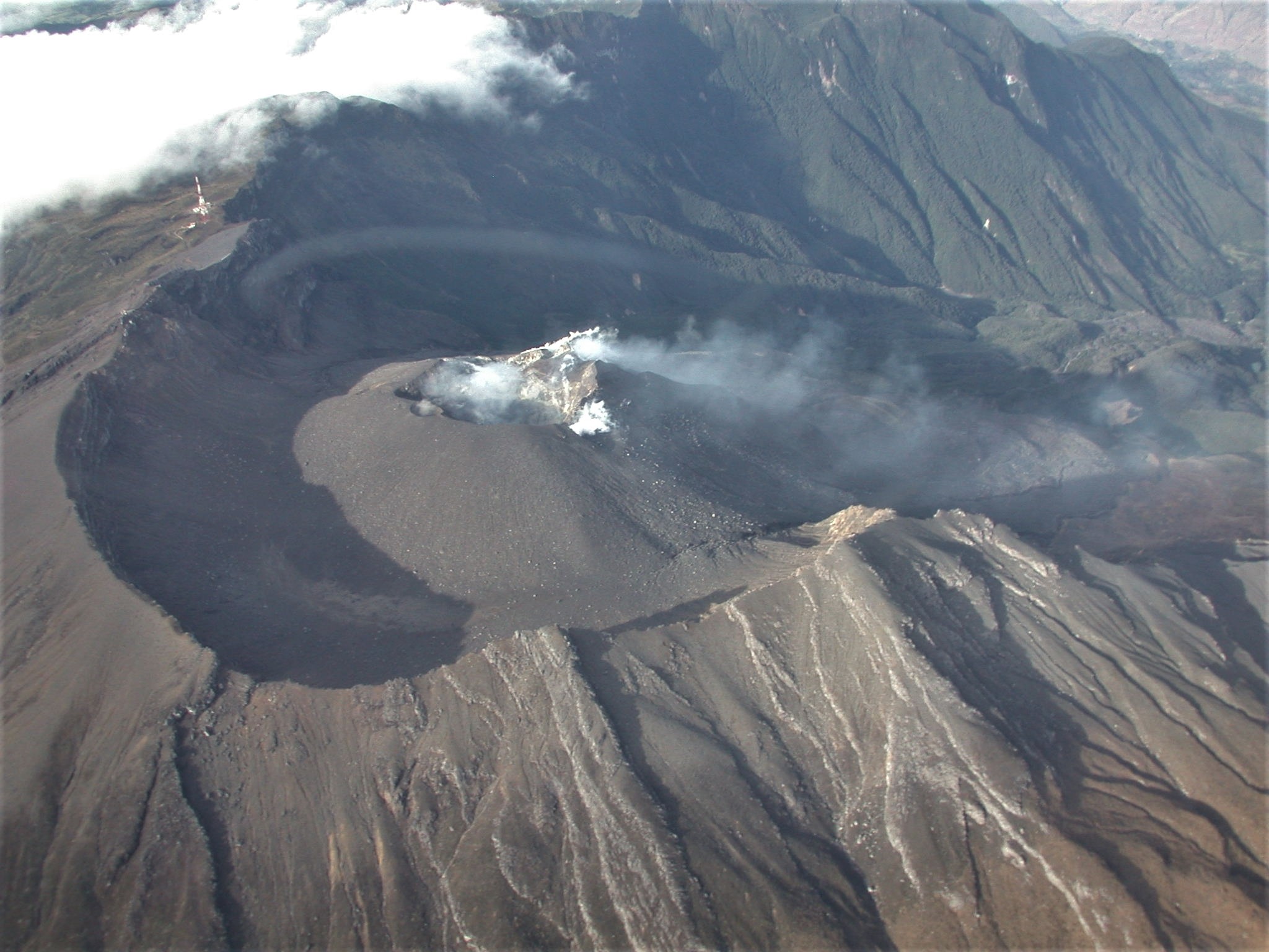
During the week, the monitoring of the volcanic activity at the level of the summit craters of Etna (Fig. 3.1) was carried out by analyzing the images of the network of surveillance cameras of the INGV Catania Section, Osservatorio Etneo ( INGV-OE), based on the processing of data obtained by surveillance drones and through two inspections by INGV-OE personnel carried out on July 24 and 25.
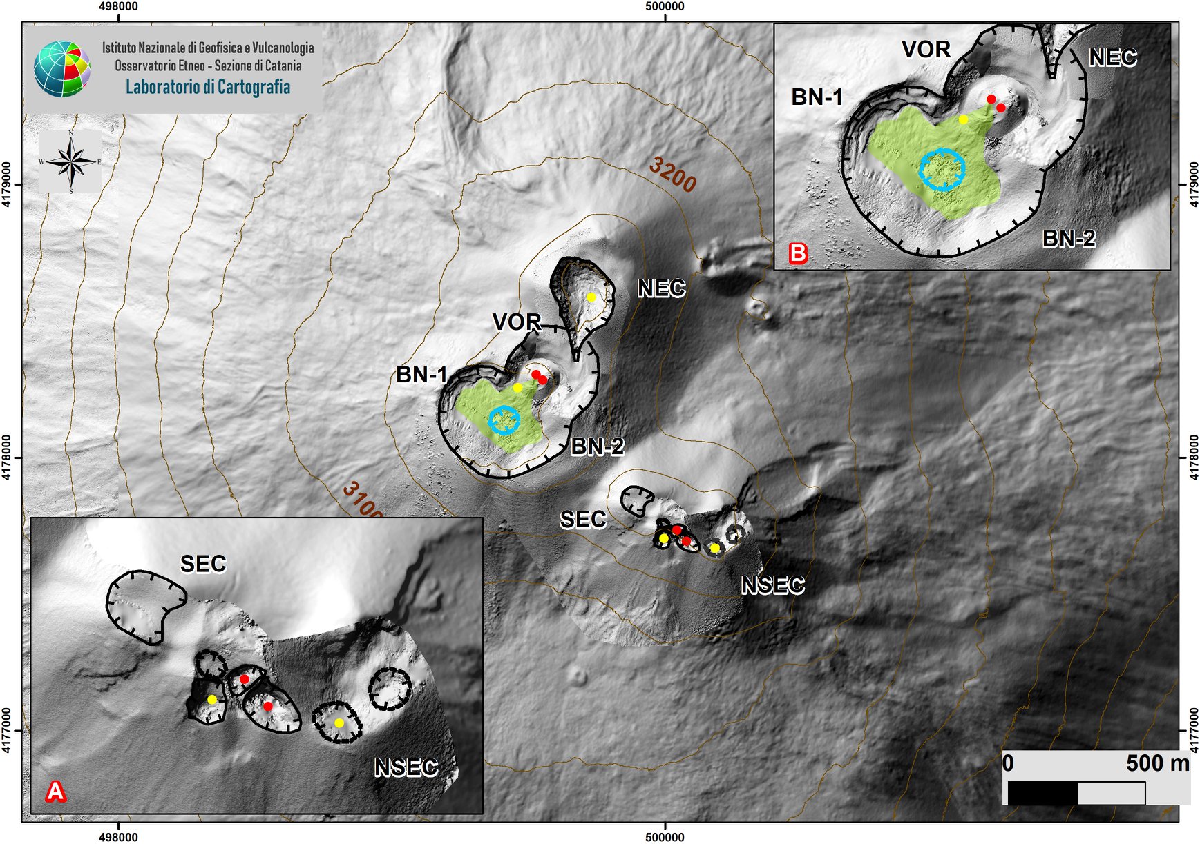
Etna summit area with zoom of the area relating to the SEC-NSEC system (A). Indented black lines indicate the edge of the summit craters (BN: Bocca Nuova, with northwest (BN-1) and southeast (BN-2) depressions; VOR: Voragine; NEC: northeast crater; SEC : south-eastern crater; and NSEC: new south-eastern crater. The indented blue line indicates the depression inside the Bocca Nuova. The yellow circles = degassing vents; red = active
During the period in question, explosive activity continued at the New Southeast Crater which is characterized by Strombolian activity of varying intensity and frequency which produces projections of slag and lithic material above the rocks. edges of the crater and ash emissions quickly dispersed in the atmosphere and / or near the summit area of the volcano.
The explosive activity at the Voragine and the New Northeast Crater also continues (bulletin n ° 29). In both cases, the eruptive activity produced by these two craters is less intense than that observed in the New Northeast Crater. In the Voragine the eruptive style is manifested by episodic ash emissions, while in the Northeast Crater there is a deep intracrater activity.
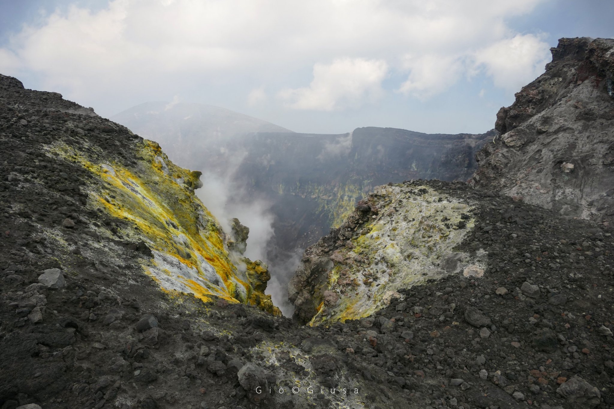
With regard to the Bocca Nuova during the inspection, it was observed that the size of the area subjected to the collapse did not show significant variations compared to what had been observed the previous week and shows a regime of variable degassing.
During the inspection on July 24, a remote survey was carried out by drone and the data inversion was used to obtain the orthophoto on the thermal and on the visible area of the summit
corresponding to the craters of Bocca Nuova and to the southwestern part of the Voragine crater (southwest side of the Voragine cone partially obliterated by volcanic gases).
The images show that the thermal anomalies present (zones from yellow to red) are linked to the characteristics of the fumarole, the black part visible on the thermal image is the degassing depression of the Bocca Nuova crater.
Volcanic tremor:
During the week in question, the average amplitude of the volcanic tremor remained at average levels with some oscillations. The sources of the volcanic tremor were located near the New Southeast Crater area at a depth of about 2800-3000 m above sea level.
Source : INGV .
Photos : Gio Giusa
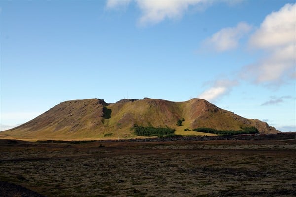
Iceland , Seismicity / Reykjanes Peninsula :
About 5,200 earthquakes were located with the Icelandic Meteorological Office’s SIL seismic system this week, more than half as many as the week before when about 2,500 earthquakes were located. There is still quite some work remaining reviewing all the earthquakes, but about 1140 earthquakes have been examined. Most of the earthquakes of the week were on Reykjanes Peninsula in two clusters, one near Þorbjörn/Svartsengi and connected to magma intrusions that have taken place there and the other by Fagradalsfjall where a swarm began on the evening of 19 July. There was also still a considerable number of earthquakes recorded at the mouth of Eyjafjörður, where a swarm began on 19 June. A total of more than 2000 earthquakes were measured at Fagradalsfjall and more than 400 have been examined.
About 600 earthquakes were measured at the mouth of Eyjafjörður and half of them have been examined. About 1000 earthquakes were measured near Þorbjörn and about 150 of them have been examined.The largest earthquake of the week was measured just west of Fagradalsfjall M5.0 on July 20 at 6:23. Another earthquake of magnitude M4.6 was measured at 05:46 in a similar location the same morning. A total of 27 earthquakes larger than M3 were measured, all but one at Fagradalsfjall. An earthquake of magnitude M3.3 was measured in Mýrdalsjökull at 05:36 on July 23rd.
One small earthquake was measured in Hekla just below magnitude M0.5. Three small earthquakes were measured in Grímsvötn, the largest M1.4.
Source : Vedur is.
Photo : Þorbjörn /Visit Reykjanes.
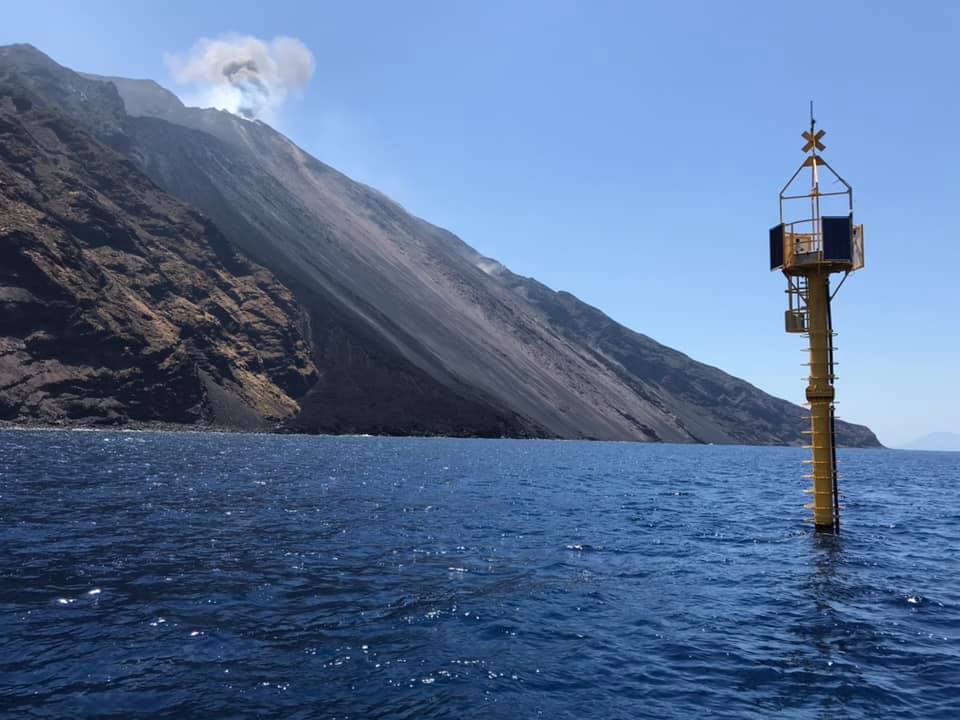
Italy , Stromboli :
Weekly bulletin from July 20, 2020 to July 26, 2020, (issue date July 28, 2020)
SUMMARY OF ACTIVITY STATUS:
In the light of surveillance data, it is highlighted:
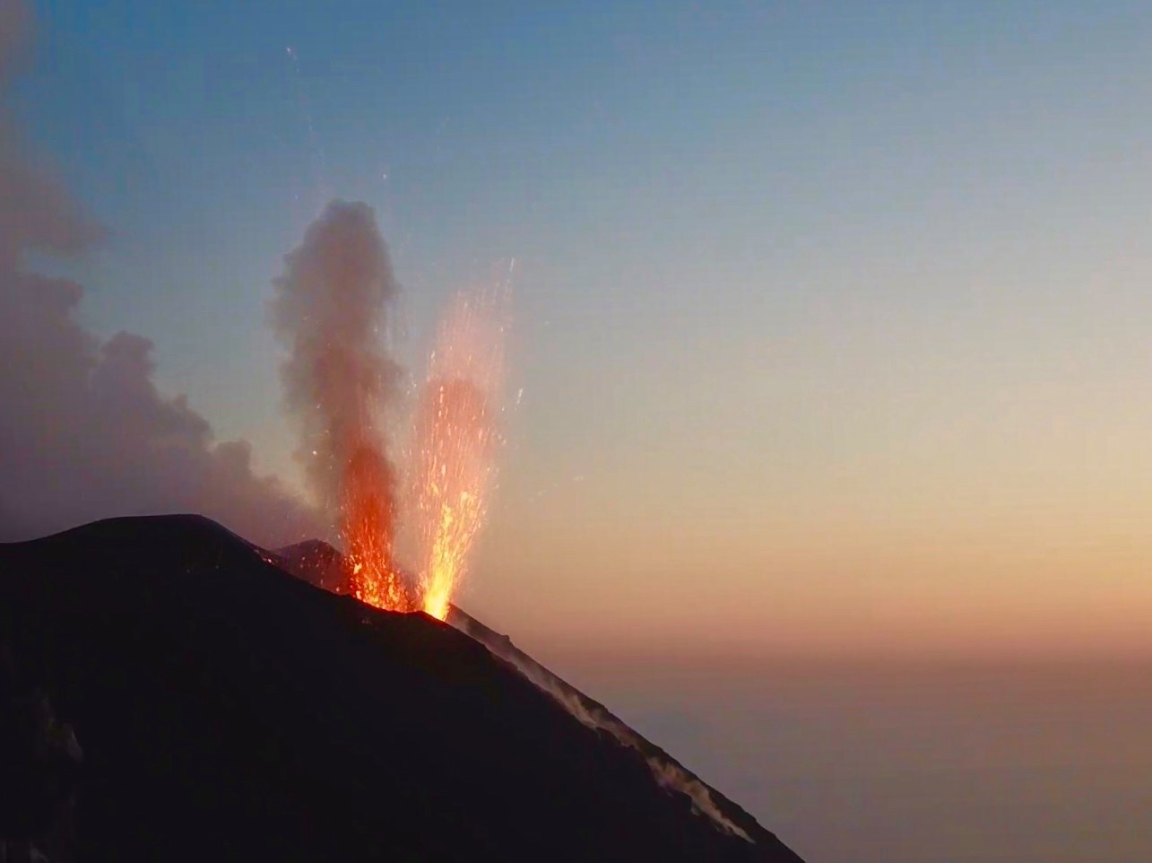
1) VOLCANOLOGICAL OBSERVATIONS: A normal explosive activity of strombolian type was observed during this period. The total hourly frequency of explosions fluctuated between medium-low values (6-7 events / h) with the sole exception of July 24 with 11 events / h. The intensity of the explosions was variable from low to high in the North crater area and was medium-high in the Center-South crater area.
2) SEISMOLOGY: The seismological parameters do not show significant variations.
4) DEFORMATIONS: The island’s soil deformation monitoring networks did not show significant variations over the period considered.
5) GEOCHEMISTRY: The flow of SO2 is at a medium-low level
There is no update of soil CO2 flow data.
There is no update of the CO2 / SO2 report because the station was destroyed during the explosion of July 19, 2020. The station is being restored.
The isotopic values of He from the last update (07/15/2020) are average values, in line with the previous ones.
6) SATELLITE OBSERVATIONS: The thermal activity in the summit area is at a medium-low level.
VOLCANOLOGICAL OBSERVATIONS
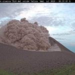
In the period under observation, the eruptive activity of Stromboli was characterized by the analysis of the images recorded by the surveillance cameras INGV-OE (altitude 190m, Punta dei Corvi and altitude 400 m, Pizzo camera damaged following the July 19 event). The description of the activity and the determination of the vents that feed the explosive activity in the individual North and Center-South zones could present uncertainties due to the framing of the 400m and 190m altitude cameras which do not allow the points to be determined. emission especially in the CS area.
During the observation period, the explosive activity was mainly produced by 3 (three) eruptive vents located in the North crater area and by at least 2 (two) eruptive vents located in the Center-South crater area . All the vents are placed inside the depression which occupies the terrace of the crater.

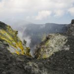
The crater terrace seen by the thermal camera located on the Pizzo sopra la Fossa on an image of July 18 with the delimitation of the crater zones of the Center-South and North zone (respectively ZONE N, ZONE C-S). The abbreviations and arrows indicate the names and locations of the active vents on the date of the image. The area above the crater terrace is divided into three ranges of heights related to the intensity of the explosions.
The N1 crater located in the North zone, with two emission points, produced explosions of low to high intensity (the products of some explosions exceeded 200 m in height) emitting coarse materials (lapilli and bombs) which fell back into abundance with radial distribution. The N2 mouth showed low intensity explosive activity (less than 80 m in height) emitting fine materials (ash) sometimes mixed with coarse materials. The average frequency of explosions was between 5 and 7 events / h. In the Center-South zone, the explosions mainly emitted fine materials with a medium-high intensity (the products emitted often exceeded 250 m in height). The frequency of the explosions fluctuated between less than 1 and 3 events / h.
On July 22, 2020, an inspection was carried out by researchers from the INGV-OE of Catania in order to take the products released from the explosive activity of July 19 and to verify the surface dispersion of the pyroclastic deposit on the ground.
During the investigation, it was observed that the ballistic projections were distributed in the eastern sector of the volcano from an altitude of ~ 500 meters along the access path to the top of the volcano.
The size and shape of the products vary from scoriaceous bombs to plurimetric and lithic clasts larger than 50 cm. Stony products appeared with a flattened shape and molded on the impact surface due to the high temperature which preserved their plastic properties. The estimated degree of vesicularity varies qualitatively from medium to high and immersed in a glass matrix. The composition of the products found between heights between ~ 500 and 800 meters seems to be associated with a brown magma (HP) while that of the products in the area between the heliport and the Pizzo is related to the light pumice stone (blond- LP) and / or mixed LP / HP.
SEM and fluorescence analyzes are in progress in the INGV-OE laboratories in order to quantitatively characterize the composition of the products.
Source : INGV .
Photos : Web cam , LGS.
Colombia , Galeras :
Weekly activity bulletin of the Galeras volcano.
Volcanic activity continues at: YELLOW LEVEL ■ (III): CHANGES IN THE BEHAVIOR OF VOLCANIC ACTIVITY.
From the monitoring of the activity of VOLCAN GALERAS, the COLOMBIAN GEOLOGICAL SERVICE (SGC) reports that:
Compared to the previous week, for the period evaluated between July 21 and July 27, 2020, there was an increase in the occurrence of recorded earthquakes, which were mainly related to the fracturing of the rock inside the volcano. This seismicity was dispersed around the volcano, mainly to the northeast of the volcanic complex, with epicentral distances less than 14 km, depths between 2.7 and 14 km from its summit (approximately more than 4200 m above sea level) and local magnitudes up to 1.3 on the Richter scale.
Favorable climatic conditions made it possible to record gas emissions from the fumarole fields on the periphery of the active cone: El Paisita, in the North, and Las Chavas, in the West, with small white columns, a low height and a variable dispersion by the action of the winds.
The other geophysical and geochemical parameters monitored did not show significant changes.
Source et photo : SGC.


No comment yet, add your voice below!