
July 03 , 2020.
La Réunion , Piton de la Fournaise :
Activity bulletin for Friday, July 3, 2020 at 7:35 a.m. (local time)
Recommended alert level: Alert 1.
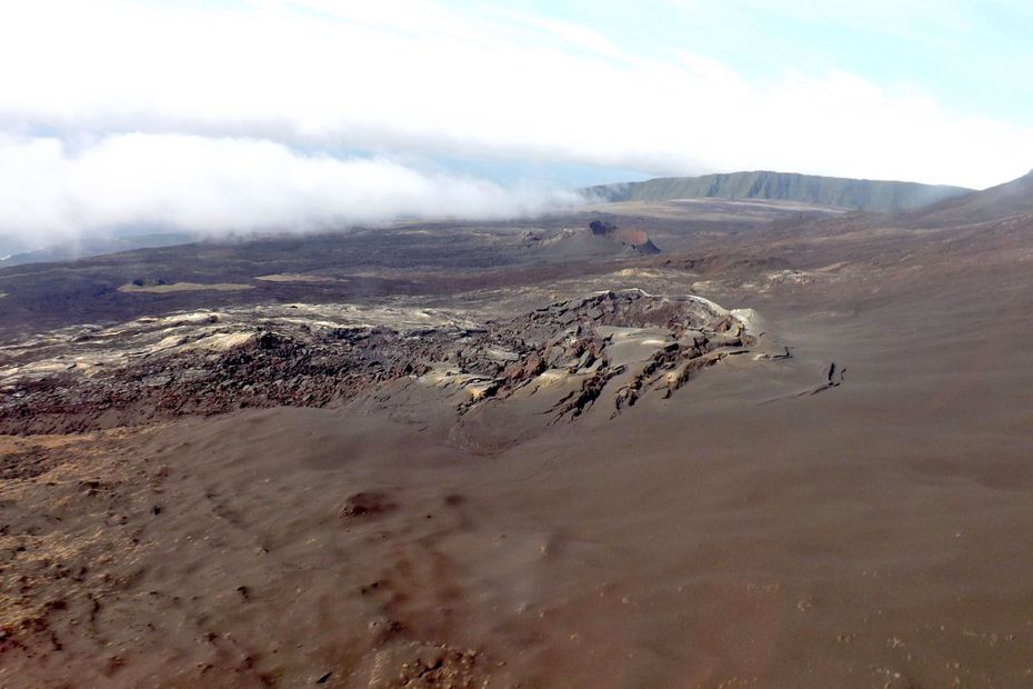
The volcanic cone formed during the April eruption called « Piton Voulvoul » • © Volcanological Observatory of Piton de la Fournaise
Since 07:20 local time, a seismic crisis is recorded on the instruments of the Volcanological Observatory of Piton de la Fournaise. This seismic crisis is accompanied by rapid deformation. This indicates that the magma is leaving the magma reservoir and is spreading to the surface. A rash is likely soon in the next few minutes or hours. Additional information will follow regarding the sector impacted by this magmatic propagation towards the surface.
Source : OVPF.
Russia / Kuril Islands , Ebeko :
VOLCANO OBSERVATORY NOTICE FOR AVIATION (VONA)
Issued: July 03 , 2020
Volcano: Ebeko (CAVW #290380)
Current aviation colour code: ORANGE
Previous aviation colour code: orange
Source: KVERT
Notice Number: 2020-149
Volcano Location: N 50 deg 41 min E 156 deg 0 min
Area: Northern Kuriles, Russia
Summit Elevation: 3791.68 ft (1156 m)
Volcanic Activity Summary:
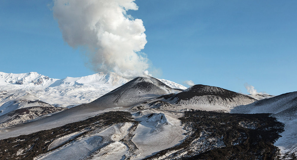
A moderate eruptive activity of the volcano continues. According to visual data by volcanologists from Severo-Kurilsk, explosion sent ash up to 2.1 km a.s.l., an ash cloud is drifting to the east of the volcano.
This activity of the volcano continues. Ash explosions up to 19,700 ft (6 km) a.s.l. could occur at any time. Ongoing activity could affect low-flying aircraft and airport of Severo-Kurilsk.
Volcanic cloud height:
6888 ft (2100 m) AMSL Time and method of ash plume/cloud height determination: 20200703/0229Z – Visual data
Other volcanic cloud information:
Distance of ash plume/cloud of the volcano: 3 mi (5 km)
Direction of drift of ash plume/cloud of the volcano: E / azimuth 100 deg
Time and method of ash plume/cloud determination: 20200703/0229Z – Visual data
Source : Kvert .
Photo : Sputnik . Alexandre Peraguis.
Hawaii , Kilauea :
19°25’16 » N 155°17’13 » W,
Summit Elevation 4091 ft (1247 m)
Current Volcano Alert Level: NORMAL
Current Aviation Color Code: GREEN
Activity Summary:
Kīlauea Volcano is not erupting. Monitoring data for the month of June show variable but typical rates of seismicity and ground deformation, low rates of sulfur dioxide emissions, and only minor geologic changes since the end of eruptive activity in September 2018.
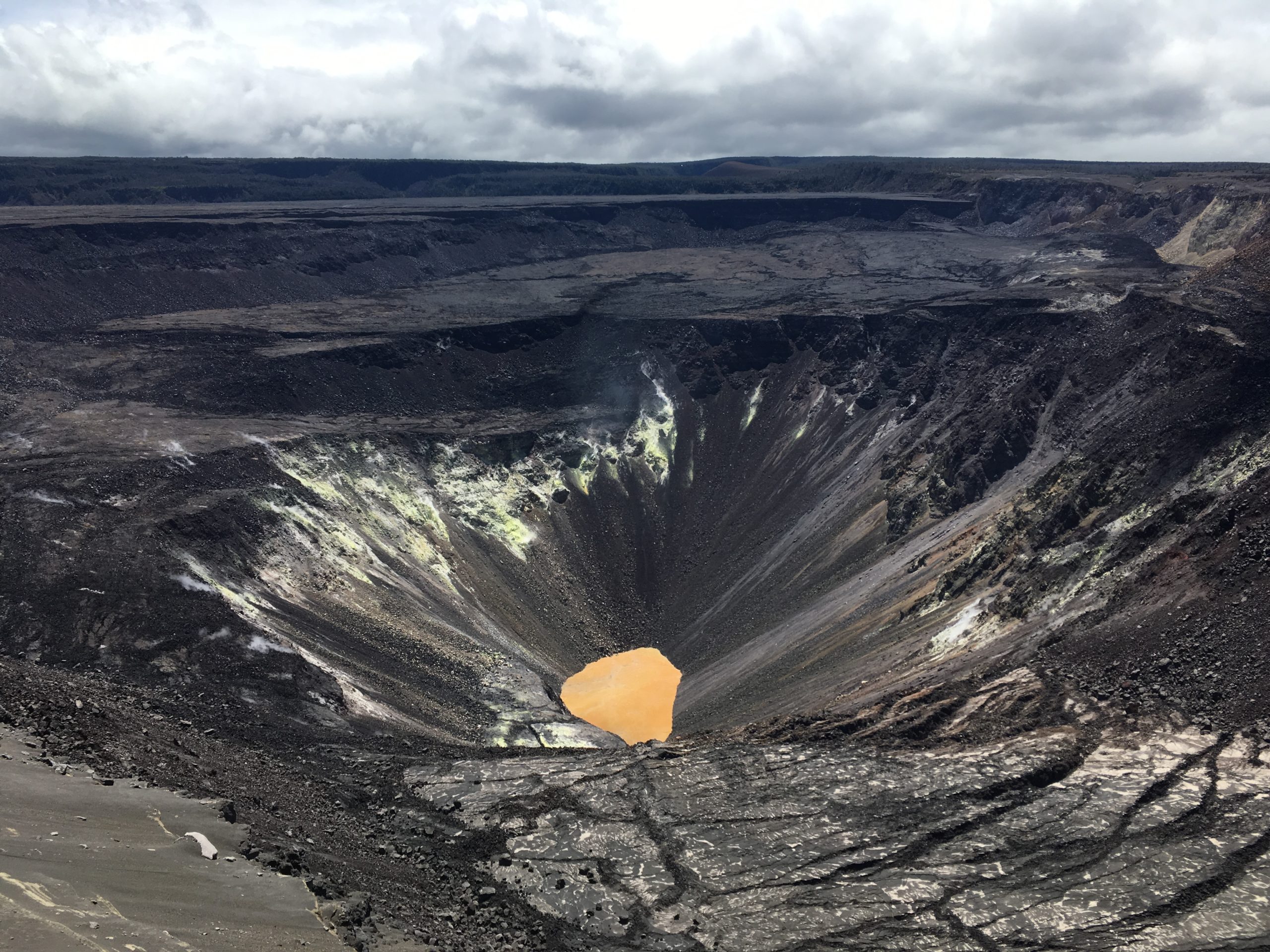
The water lake within Halema‘uma‘u crater, at the summit of Kīlauea, continues to slowly rise, with no significant changes in recent weeks. USGS photo by M. Patrick.
Observations:
Monitoring data have shown no significant changes in volcanic activity in June.
There were approximately 1200 earthquakes during the month of June at Kīlauea, an approximate 45 percent increase in the number of earthquakes detected in May. The majority of the increase was from earthquakes detected under the upper East Rift Zone, connecting the summit to the East Rift Zone, and heightened activity deep beneath the summit (4-7 miles) that lasted for over a hundred hours (2020-06-13 to 2020-06-17 UTC).
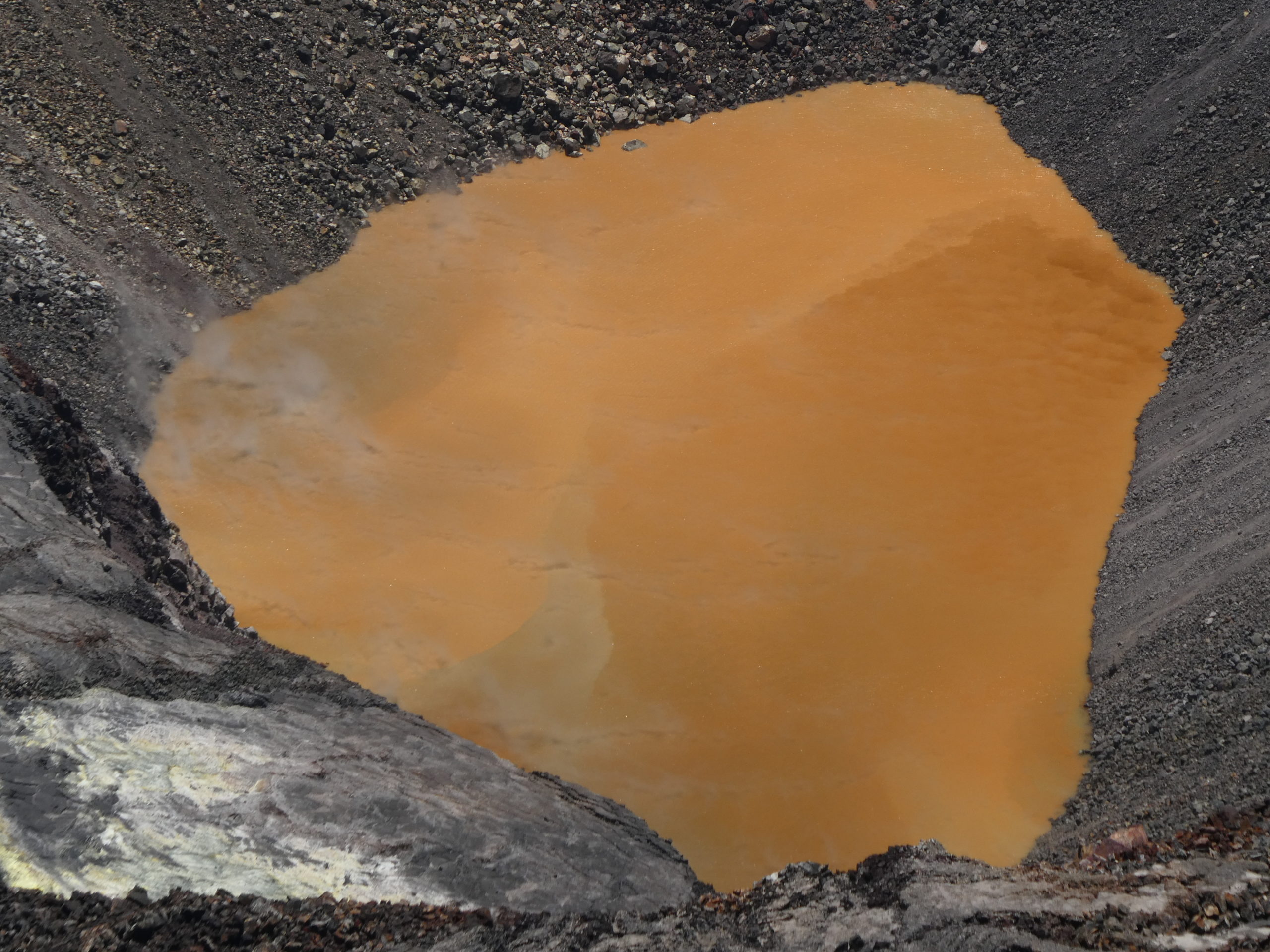
No significant changes were observed during today’s visit to monitor Kīlauea’s summit water lake. The lake surface exhibited some interesting color variations today, but within the range of those previously observed. The sharp color boundary between tan and brown zones has been common. Today, a wedge-shaped, slightly greenish zone was present in the west portion of the lake (towards bottom of image). Laser rangefinder measurements indicate that the lake level continues to slowly rise. USGS photo by M. Patrick.
Over the past month, summit tiltmeters recorded 7 deflation-inflation events–an increase from 4 recorded last month. In the middle East Rift Zone, the increased deformation rates that began in March 2020, consistent with an episode of rift inflation west of Highway 130, and that lessened and flattened during May, have returned to their pre-March trend. The long-term trend of deformation at Kilauea’s summit and middle East Rift Zone continue to show inflation, consistent with magma supply to the volcano’s shallow storage system. GPS stations on Kīlauea’s south flank continue to show elevated rates of seaward motion. HVO continues to carefully monitor all data streams along the Kīlauea East Rift Zone and south flank for important changes.
Sulfur dioxide emission rates are low at the summit, consistent with no significant shallowing of magma. Some amount of sulfur dioxide is being dissolved into the crater lake at the bottom of Halema’uma’u and work continues to try and quantify this process. As of June 30th, the lake depth was approximately 39 meters or 128 feet. The crater lake was last sampled by UAS in January and additional sampling with UAS is planned. Sulfur dioxide emission rates are below detection limits at Puʻu ʻŌʻō and the lower East Rift Zone
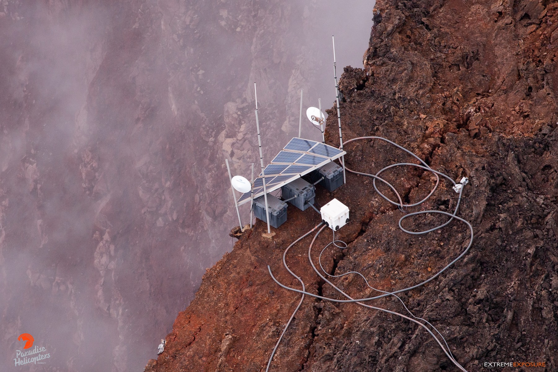
solar panel and webcam on the rim of Pu‘u ‘Ō‘ō’s crater
Although not currently erupting, areas of persistently elevated ground temperatures and minor release of gases are still found in the vicinity of the 2018 lower East Rift Zone fissures. These include steam (water), very small amounts of hydrogen sulfide, and carbon dioxide. These conditions are expected to be long-term. Similar conditions following the 1955 eruption continued for years to decades.
Source : HVO.
Photos : HVO / USGS par M. Patrick , Bruce Omori.
Chile , Nevados of Chillan :
Yellow alert surveillance for the municipalities of Pinto and Coihueco for the activity of the Nevados de Chillán volcanic complex
July 02, 2020 | 9:16 PM | Ñuble
According to information provided by OVDAS – SERNAGEOMIN, the Nevados de Chillán volcanic complex maintains the technical alert level at the yellow level, which includes variations in the levels of parameters derived from monitoring which indicate that the volcano is above its threshold basic and the process is unstable, can evolve by increasing or decreasing these levels, a likely rash could develop in a few weeks or months.
Regarding the latest special report on volcanic activity (REAV), published today, it should be noted that the eruptive cycle of the volcanic complex continues to evolve regularly and with some significant changes.
It should be noted that given the new history of surface activity and the instrumental parameters of the internal dynamics of the volcano, an explosive scenario of moderate magnitude is expected. This is associated with the possibility of destabilization of the volcanic system, as a result of the mass and heat provided by the effusive body.
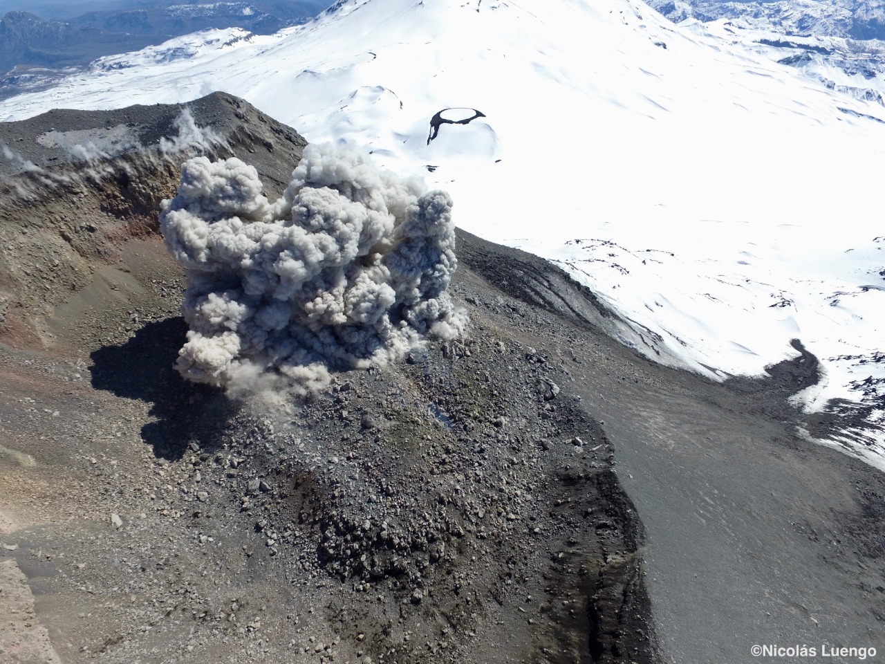
In this scenario, the presence of eruptive columns up to 5 km high, ballistic projections, falling ash, avalanches of volcanic debris, the generation of pyroclastic currents at high speed (> 100 km / h) and high temperatures ( > 200) would be expected due to the collapse of the columns, the range of which could have an impact up to 5 km towards the North-East sector and 3 km towards the West and the South-West. Finally, the activity described, reinforced by the availability of water (snow or rain) with the new surface magmatic body, could generate low-volume lahars channeled by neighboring ravines, mainly in the canals of the valleys to the north and northeast of the Nicanor crater.
In connection with the above, the yellow alert of the civil protection system is maintained, for the municipalities of Pinto and Coihueco, region of Ñuble, for the activity of the Nevados de Chillán volcanic complex, in force since December 31, 2015.
It should be noted that the civil protection system must keep emergency plans up to date and recommend to the community not to approach the active crater, keeping a minimum distance of 5 kilometers in the northeast sector and to 3 kilometers in the West-South-West, around the crater.
Source : Onemi.
Photo : Nicolas Luengo.
Guatemala , Santiaguito :
Location: 14 ° 44 ’33 ˝ Latitude N; 91 ° 34’13˝ Longitude W
Height: 2500msnm
Atmospheric conditions: Clear
Wind: southeast.
Precipitation: 5.08 mm.

Activity:
The Caliente dome is observed with a white fumarole coming mainly from water vapor at an altitude of 3,000 m above sea level (9,843 feet), which the wind moves to the northwest and west of the volcanic complex. Weak and a few moderate explosions were recorded, reaching 3,300 meters (10,827 feet). Constant avalanches of boulders, moderate to strong are observed on the South, South-East and South-West flanks, some reaching the base of the dome, with a slight presence of ash in the volcanic perimeter. An incandescence is observed on the crater of the Caliente dome. (The recommendations of the special bulletin of the Santiaguito volcano 39-2020 are still in force).
Source : Insivumeh.
Photo : annie winson , earthobservatory.sg


No comment yet, add your voice below!