
July 01 , 2020.
Italy / Sicily , Etna :
Weekly bulletin from June 22, 2020 to June 28, 2020
(issue date June 30, 2020)
SUMMARY OF THE STATUS OF THE ACTIVITY
In light of the monitoring data, it is underlined:
1) VOLCANOLOGICAL OBSERVATIONS: Moderate deep intra-crater strombolian activity in the New Southeast Crater; sporadic and low ash emissions at the Voragine crater.
2) SEISMOLOGY: Low seismic fracturing activity; amplitude of the volcanic tremor at the high level.
3) INFRASOUND: Moderate infrasonic activity in the area of the Southeast Crater / New Southeast Crater.
4) DEFORMATIONS: In an inflationary context, the Etna soil deformation monitoring networks did not show any significant changes last week.
5) GEOCHEMISTRY: The flow of SO2 is at a medium-low level.

The flow of CO2 from the soil is maintained at average values.
The partial pressure of dissolved CO2 does not show significant variations.
The C / S values are average values (last measurement of 06/19/2020)
The isotopic values of helium He confirm the downward trend (last update of 12/06/2020).
6) SATELLITE OBSERVATIONS: The thermal activity in the summit area is low.
VOLCANOLOGICAL OBSERVATIONS.
The monitoring of the volcanic activity in the summit craters of Etna, during the week in question, was carried out by analyzing the images of the network of surveillance cameras of the INGV section of Catania, Etneo Observatory (INGV- OE ) and through an overflight carried out with the Aw139 helicopter made available by the 2 Air Corps of the Coast Guard of Catania on June 25 and an inspection carried out in the crater area at the top of INGV personnel on June 26.
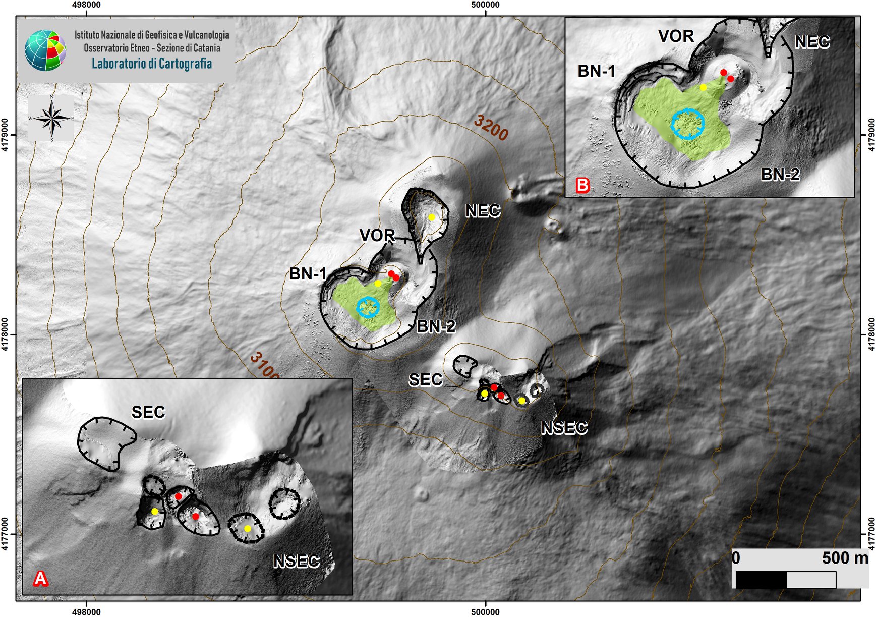
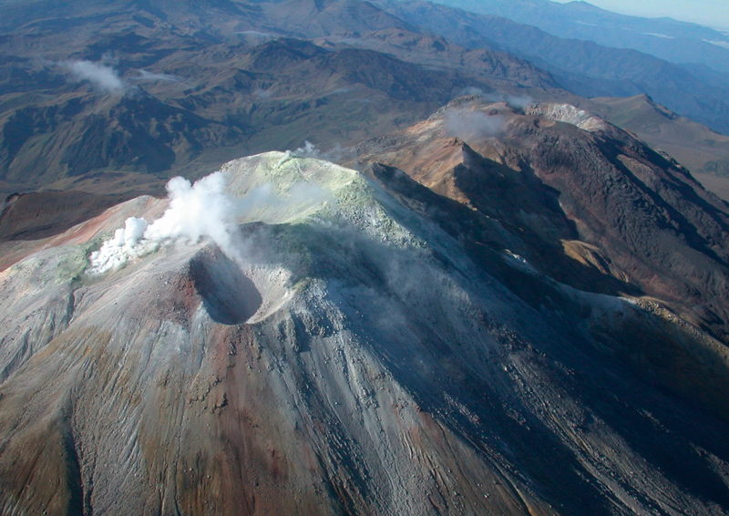
DEM of the summit area of Etna with zoom of the sectors linked to the SEC-NSEC system (A) and of the crater BN and VOR (B). The indented black lines indicate the edge of the summit craters (BN: Bocca Nuova, with the northwest (BN-1) and southeast (BN-2) depressions; VOR: Voragine; NEC: North-East Crater; SEC : Southeast Crater, and NSEC: New Southeast Crater. The recessed blue line indicates the depression inside the Bocca Nuova. Yellow circles = degassing outlets; red = active outlets.
Overall, the state of activity of the upper craters did not show significant changes compared to what had been observed the previous week (see Rep. N ° 26/2020), and was mainly characterized by intense degassing of the mouths of the South-East Crater-New South-East crater system (SEC / NSEC) and of the North-East crater (NEC), subordinated to the Voragine crater (VOR) and the Bocca Nuova (BN) . In particular, the thermal and visible exposures carried out during the overflight on June 25 showed that near the crater of Bocca Nuova, the crater which develops at the center of the depression of the crater does not present thermal anomalies and is affected by a slight degassing from below and by a system of fumaroles along the southern edge of the well characterized by apparent temperatures of approximately 250 ° C +/- 50 °. The lava field produced by the effusive activity of Voragine in recent months has cooled and shows certain areas with apparent temperatures of around 250 ° C +/- 50 °.
The crater of Voragine is affected only by sporadic and modest emissions of ash from the main slag cone which are characterized by an apparent temperature of approximately 350 ° C +/- 50 ° C inside the mouth. The North-East crater shows normal degassing of the bottom with internal temperature anomalies of low temperature.
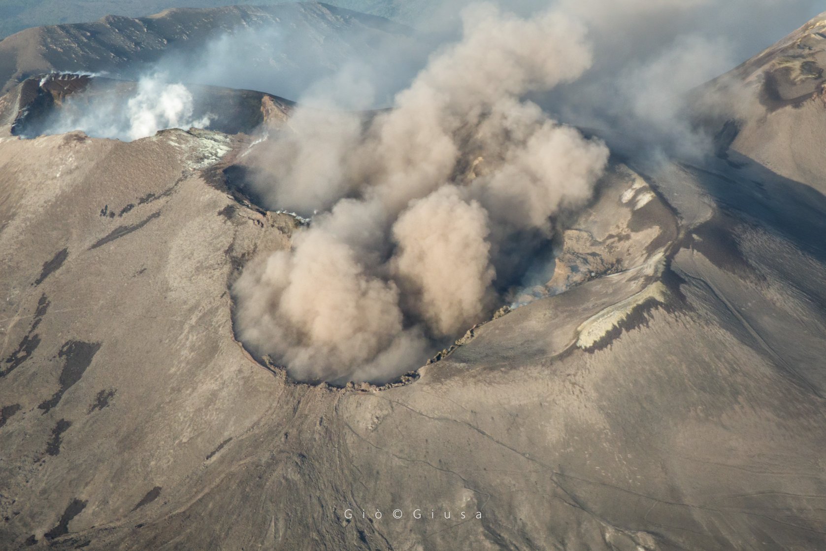
Finally, with regard to the New South-East Crater (NSEC), moderate intra-crater strombolian activity continues in the mouths of the « saddle cone ». This activity is accompanied by an intense pulsed degassing, which results in lightning at night of variable intensity, and which remains confined in the depression of the crater without producing any launch of pyroclastic material on the surface. In particular, the overview did not show any thermal anomalies in correspondence with the mouths of the « saddle cone », emphasizing that this activity affects the deep part of the duct while the thermal anomalies are linked to the degassing of the various fumarole systems present along the edges of the crater and on the sides of the SEC-NSEC system.
Volcanic tremors:
During the week, the average amplitude of the volcanic tremor remained at a high level, with values completely comparable to those recorded the last days of the previous week. The source of the tremor was constantly located in the area of the new southeast crater, at an altitude of about 2,900-3,000 meters above mean sea level.
Source : INGV.
Photos : Gio Giusa.
Japan , Nishinoshima :
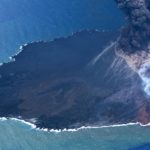
Nishinoshima Island looks healthier than ever. In the photos shared by the Japanese Coast Guard via Sherine France, fairly tall lava fountains stand out. It seems that the slag cone opened on one side.
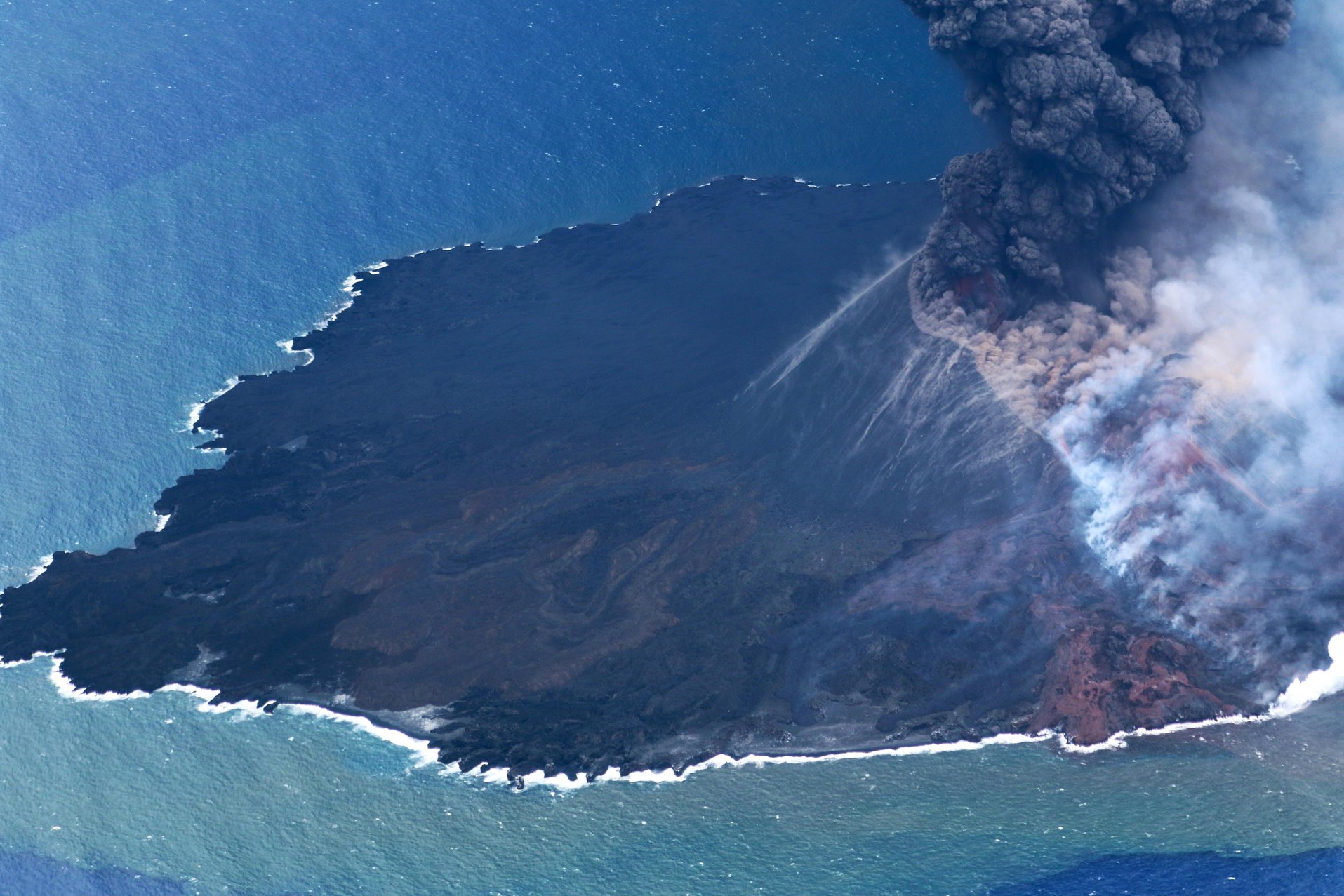
Nishinoshima seen by the Japanese Coast Guard on June 29, 2020. The flows now occur on the southwest side while the previous ones were on the east side. It is possible that a morphological change of the crater has occurred.

The VAAC Tokyo reports this July 01 at 2:30 am that ash emissions continue on Nishinoshima. Confirmed by Himawari-8 satellite data.
Sources : Sherine France / Gardes cotes japonais .
Alaska , Makushin :
53°53’24 » N 166°55’30 » W,
Summit Elevation 5906 ft (1800 m)
Current Volcano Alert Level: ADVISORY
Current Aviation Color Code: YELLOW
Over the past two weeks, there has been increased earthquake activity at Makushin Volcano. The activity started on June 15 with a magnitude 4.2 earthquake, followed over the next 24 hours by several additional significant earthquakes ranging in magnitude from 3.1 to 4.1. These larger earthquakes have been accompanied by hundreds of smaller earthquakes located by AVO that are continuing up to the present time. The rate of occurrence and size of the earthquakes initially declined for about a week following the magnitude 4.2 earthquake. However, since June 24, the rate and size of the earthquakes has fluctuated with the most recent increase associated with two earthquakes of magnitude 3.0 and 3.8 that occurred at 4:53 PM and 6:02 PM on June 28. All of the earthquakes are clustered about 10 km (6 miles) east of the summit of the volcano at a depth of about 8 km (5 miles). The largest earthquakes have been felt strongly by residents of Unalaska.

USGS geologist Allan Lerner and pilot Kevin Franks make observations of degassing from fumaroles on the north flank of Makushin Volcano’s summit crater.
The exact cause of this increased earthquake activity, in terms of possible volcanic or tectonic processes, is uncertain at this time. The earthquakes may be related to the movement of magma beneath the east side of Makushin Volcano, interactions between an earthquake fault and the nearby geothermal field, the activation of more than one fault in this area, or a combination of these scenarios. Because of the distance and depth of the locations of the earthquakes from the summit of Makushin Volcano, and the absence of other forms of volcanic unrest such as increased steaming, gas emission, or ground deformation, there is no indication that the present earthquake sequence will necessarily lead to a volcanic eruption. In response to this earthquake activity, AVO raised the Aviation Color Code to Yellow on June 15 and plans to continue close monitoring of seismic activity, ground deformation, and gas emissions at Makushin Volcano over the coming weeks and will provide additional information as it becomes available
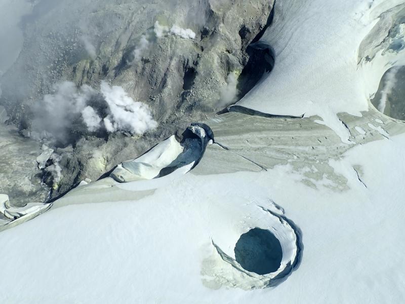
August 2019 views of the summit crater of Makushin Volcano. Heat from vigorous fumarolic activity is melting depressions, holes, and caves in the glacial ice.
Makushin Volcano is located on northern Unalaska Island in the eastern Aleutian Islands. Makushin is a broad, ice-capped stratovolcano that rises to an elevation of 6680 feet. The summit caldera, 3 km diameter, is the site of frequent steam and minor ash eruptions; however, no large eruptions have occurred in this century. Makushin is monitored by a network of seismic stations, web camera, GPS, satellite images, and regional infrasound and lightning detection data. The community of Unalaska and port of Dutch Harbor are located 25 km (16 miles) east of Makushin volcano.
Source : AVO .
Photos : Kern, Christoph.
Colombia , Cumbal :
Cumbal volcanic complex weekly activity bulletin
The activity of the Cumbal volcanic complex continues at the YELLOW LEVEL ■ (III): CHANGES IN THE BEHAVIOR OF VOLCANIC ACTIVITY.
According to the monitoring of the activity of the CUMBAL VOLCANIC COMPLEX, the COLOMBIAN GEOLOGICAL SERVICE (SGC) reports that:
Between June 23 and June 29, 2020, the seismic activity of the Cumbal volcanic complex showed a slight decrease compared to the previous week. The predominance of events related to the fracture of the rock in the volcanic complex continues. The main source of the localized earthquakes was located near the crater of La Plazuela (northeast sector of the complex), at distances less than 7.0 km from the volcanic complex, with depths less than 9 km and a magnitude maximum local of 1.0 on the Richter scale. No earthquake has been reported to be felt.
The climatic conditions of the region prevented the observation of gas emissions from the top of the volcanic complex.
The other volcanic monitoring parameters did not show significant variations.
The COLOMBIAN GEOLOGICAL SERVICE continues to follow the evolution of the volcanic phenomenon and will continue to report the observed changes in due course.
Source : SGC.
Photo : Ingeominas.


No comment yet, add your voice below!