May 15, 2020. EN. Colombia : Nevado del Ruiz , La Guadeloupe : La Soufrière , Ecuador : Reventador , Costa Rica : Turrialba / Poas / Rincon de la Vieja .

May 15 , 2020.


Colombia , Nevado del Ruiz : 

Weekly activity bulletin of the Nevado del Ruiz volcano
The level of activity continues at the level of activity yellow or (III): changes in the behavior of volcanic activity.

Regarding the monitoring of the activity of the Nevado del Ruiz volcano, the COLOMBIAN GEOLOGICAL SERVICE reports that:

According to the results obtained from the monitoring of the activity, through the various parameters evaluated, the Nevado del Ruiz volcano continued to exhibit an instability of its behavior during the last week. An acceleration of the volcanic process and therefore changes in the level of activity of the volcano are not excluded.
The seismicity generated by the fracturing of the rocks showed a slight decrease in the number of earthquakes and the seismic energy released, compared to the previous week. This type of seismicity was mainly located in the South-East, South-South-East, North-East of the volcano and in the Arenas crater, at depths varying between 0.4 and 5.9 km. The maximum magnitude recorded during the week was 1.0 ML (local magnitude) corresponding to the earthquake recorded on May 10 at 9:15 a.m. (local time) located in the Arenas crater, 1.6 km deep.


Seismicity related to fluid dynamics inside volcanic conduits showed a slight decrease in both the number of events recorded and the seismic energy released, compared to the previous week. This seismic activity was characterized by the occurrence of continuous volcanic tremors, tremor pulses, earthquakes of the long period type and of the very long period type. These seismic events presented varying energy levels and spectral contents. Some of these signs were associated with small emissions of gas and ash, which were confirmed by cameras installed in the area of ​​the volcano and by reports from officials of the Los Nevados National Natural Park.

The deformation of the volcanic surface, measured from GNSS (Global Navigation Satellite System) stations, showed some minor changes associated with volcanic activity. Over the past week, the Mirova and NASA FIRMS web portals have not reported any thermal anomalies at the volcano.

The Nevado del Ruiz volcano continues at a yellow activity level.

Source et photo  : SGC.


La Guadeloupe , La Soufrière :

Since the beginning of 2018 we have been witnessing a cyclic process of injecting deep magmatic gases at the base of the hydrothermal system at a depth between 2 and 3 km below the summit. This generates a recurrent process of overheating and overpressure of the hydrothermal system which results in:

1) disturbances in the circulation of hydrothermal fluids;
2) the evolution of the activity of fumaroles at the summit, one of which shows the projection of hot, acid mud over a few meters;
3) an increase in the swarm volcanic seismicity;
4) some volcanic earthquakes felt (four between February and April 2018) including an earthquake of magnitude M4.1 on April 27, 2018, the strongest since 1976;
5) deformations of small amplitude and limited to the dome of La Soufrière of the order of 3-7 mm / year and the continued opening of the summit fractures;
6) the fluctuation in the flow rates of fumarolic gas from a pressurized hydrothermal reservoir;
7) an increase in thermal anomalies in the soil at the top of La Soufrière.

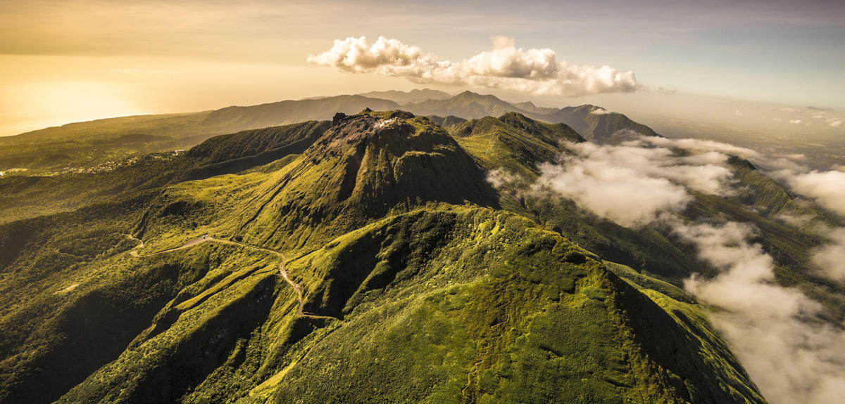
While these phenomena prompt the observatory for instrumental vigilance, they are not yet clearly associated with an anomaly in the other monitoring parameters which could indicate a possible rise in magma. The latter would typically, but not systematically manifest itself by numerous deep and / or felt earthquakes, large-scale deformations beyond the dome, and the emission of sulfur gases at high temperature (> 150 ° C). Based on the observations of the OVSG-IPGP recorded during the month of April 2020 and summarized in this bulletin, and in accordance with the provisions provided by the authorities, the level of volcanic alert remains:

The likelihood of short-term eruptive activity remains low. However, given the renewed seismic and fumarolic activity recorded since February 2018, a change in the regime of the volcano has been noted such that an intensification of the phenomena in the future cannot be excluded. Consequently, the OVSG-IPGP is in a state of heightened vigilance. The gaseous fumes around and downwind of the main fumaroles of the summit (notably the South Crater, the Tarissan, and the Gouffre 1956) have, since 1998, proven risks of irritation and burns (eyes, skin, respiratory tract) .

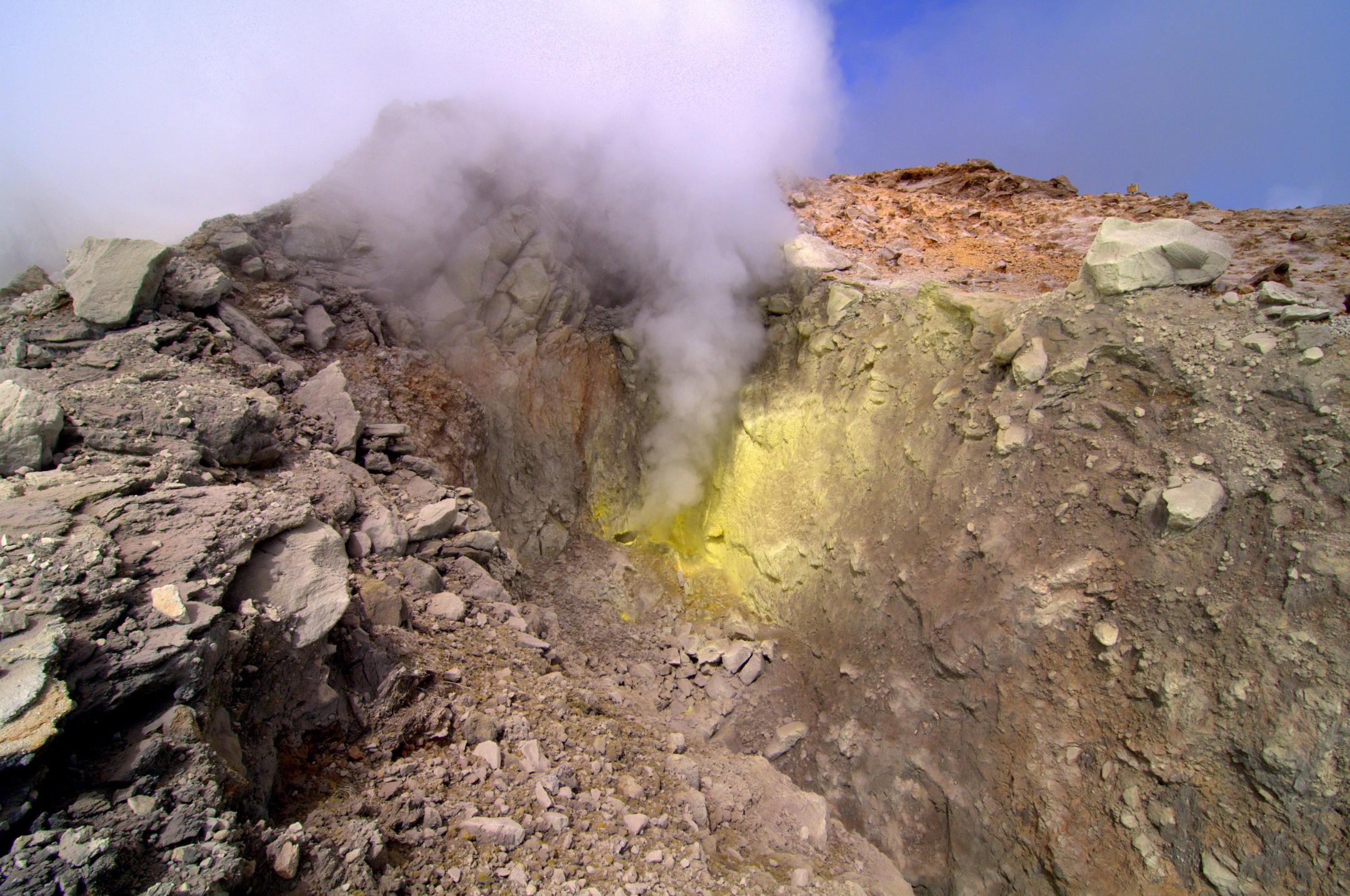
Taking into account the development described above and other observations on the activity, the OVSGIPGP considers that it is important to keep, as a precaution, a distance of at least 50 m radius around the main centers of emission of fumarolic gas (Crater South, Crater South Central, Crater South North, Napoleon North, Napoleon East, Gouffre 1956, Gouffre Tarissan). In consideration of the evolution of the anomaly zone at the top (with the propagation of heat on the ground; the resurgence of the activity of fumaroles, accompanied by the appearance over time of new emission and projection centers of mud and fragments; indications of the impact on the ground and on vegetation of sulfur and acid gases) and therefore of a general increase in areas of instability, the Prefecture of Guadeloupe with Order No. 2019/001 CAB SIDPC of January 14, 2019 instituted regulated access to the summit of the Soufriere volcano, based on the identification of a security perimeter and on the prohibition of any unauthorized person from crossing it.

Source : IPGP.

Read the whole article http://volcano.ipgp.fr/guadeloupe/Bulletins/last_bulletins.pdf

Photos : A.-Brusini-hemis-fr , F. BEAUDUCEL/IPGP 2010 .


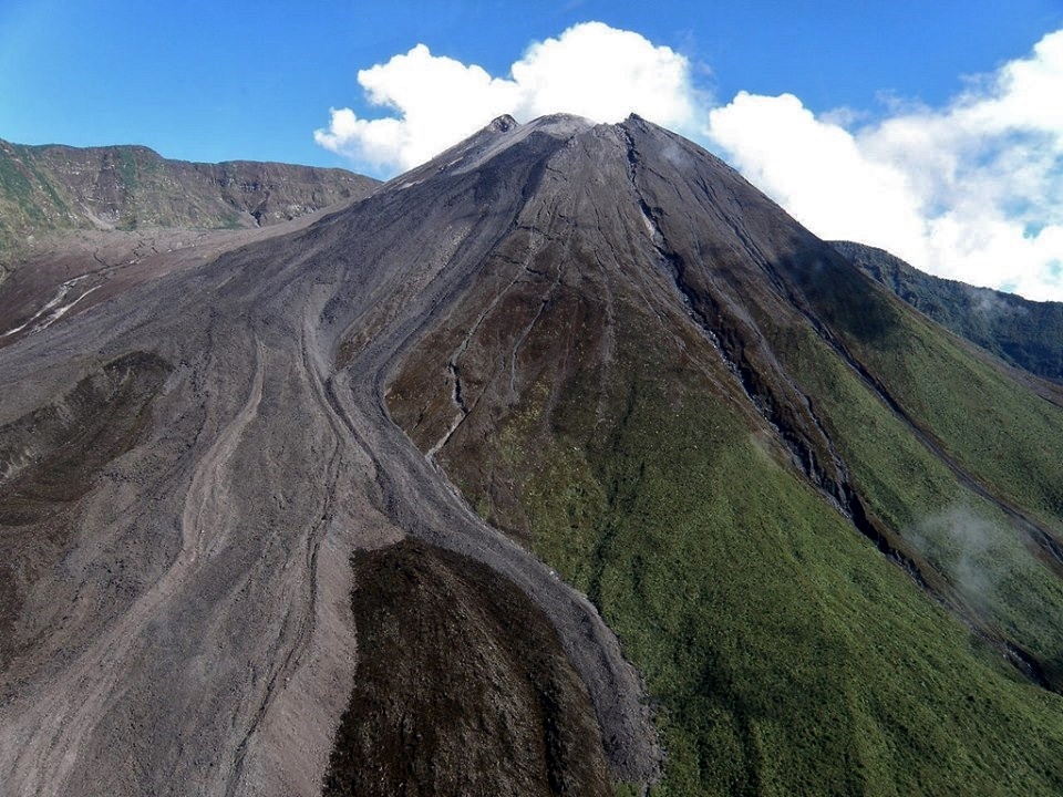
Ecuador , Reventador :

DAILY REPORT OF THE STATE OF THE VOLCANO REVENTADOR, Thursday May 14, 2020.
Information Geophysical Institute – EPN.

Surface activity level: High, Surface trend: No change.
Internal activity level: High, Internal trend: No change.

Seismicity: From May 13, 2020, 11:00 a.m. to May 14, 2020, 11:00 a.m.
Long Period Type (LP): 19 events
Explosions (EXP): 22 events
Emission tremors: (TE): 6.
Harmonic tremors: (TA): 2.

Rains / lahars: Not recorded.

Emission / ash column: Emissions of vapor, gas and ash were observed in a western direction, which exceeded 1000 m above the level of the crater. In the satellite images shared by the VAAC, 3 emission alerts were reported in a west direction, with a maximum height of 2538 m above the summit

Other monitoring parameters: no change.

Observations: Emissions of gas and ash at night and in the morning, signaled by VAAC alerts and visual cameras. During the night, an incandescence was observed at the level of the summit, accompanied by the descent of incandescent blocks on the south-eastern flank 300 m below the crater. Cloudy area at the moment.

Alert level: Orange.

Source : IGEPN.

Photo : alex-steele-via-fb 


Costa Rica , Turrialba / Poas / Rincon de la Vieja :

Weekly bulletin from the volcanic monitoring program, May 11, 2020.

Turrialba volcano:

Lat: 10.025 ° N; Long: 83,767 ° W;
Altitude: 3340 m above sea level
Current activity level: 2 (active volcano)
Potentially associated hazards: gas, ash emission, proximal ballistic projections.

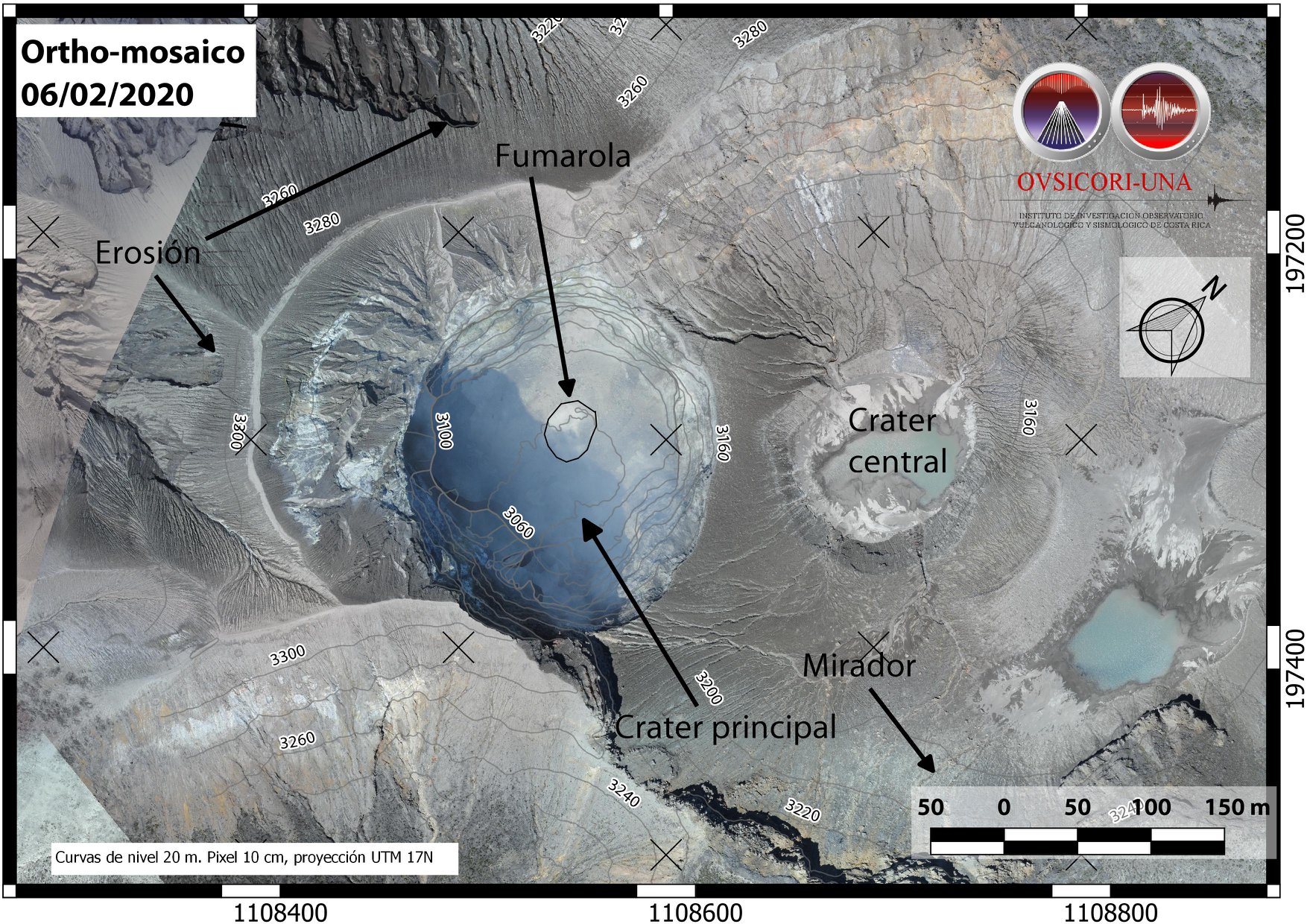
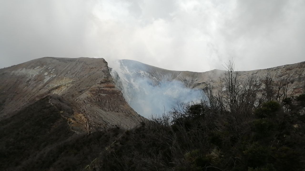
Orthophotography of the Turrialba volcano, result of the flight with drone of February 6, 2020, carried out by Cyrill Muller and Mario Angarita from the geodesy department of OVSICORI-UNA.
An orthophotograph is obtained by a set of aerial images, which have been corrected to represent an orthogonal projection without perspective effect, and in which it is therefore possible to take precise measurements.

No ash emission was detected. Seismicity remains stable. The trend towards contraction and collapse of the Turrialba-Irazú massif continues, in particular towards Irazú and the summit of Turrialba. The CO 2 / SO 2 and H 2 S / SO 2 ratios have continued to increase since mid-March, the flow of SO 2 remains stable.

Poas Volcano:

Lat: 10.2 ° N; Long: 84.233 ° W;
Altitude: 2780 m above sea level
Current activity level: 2 (active volcano)
Potentially associated hazards: gas, groundwater eruptions, proximal ballistic projections.

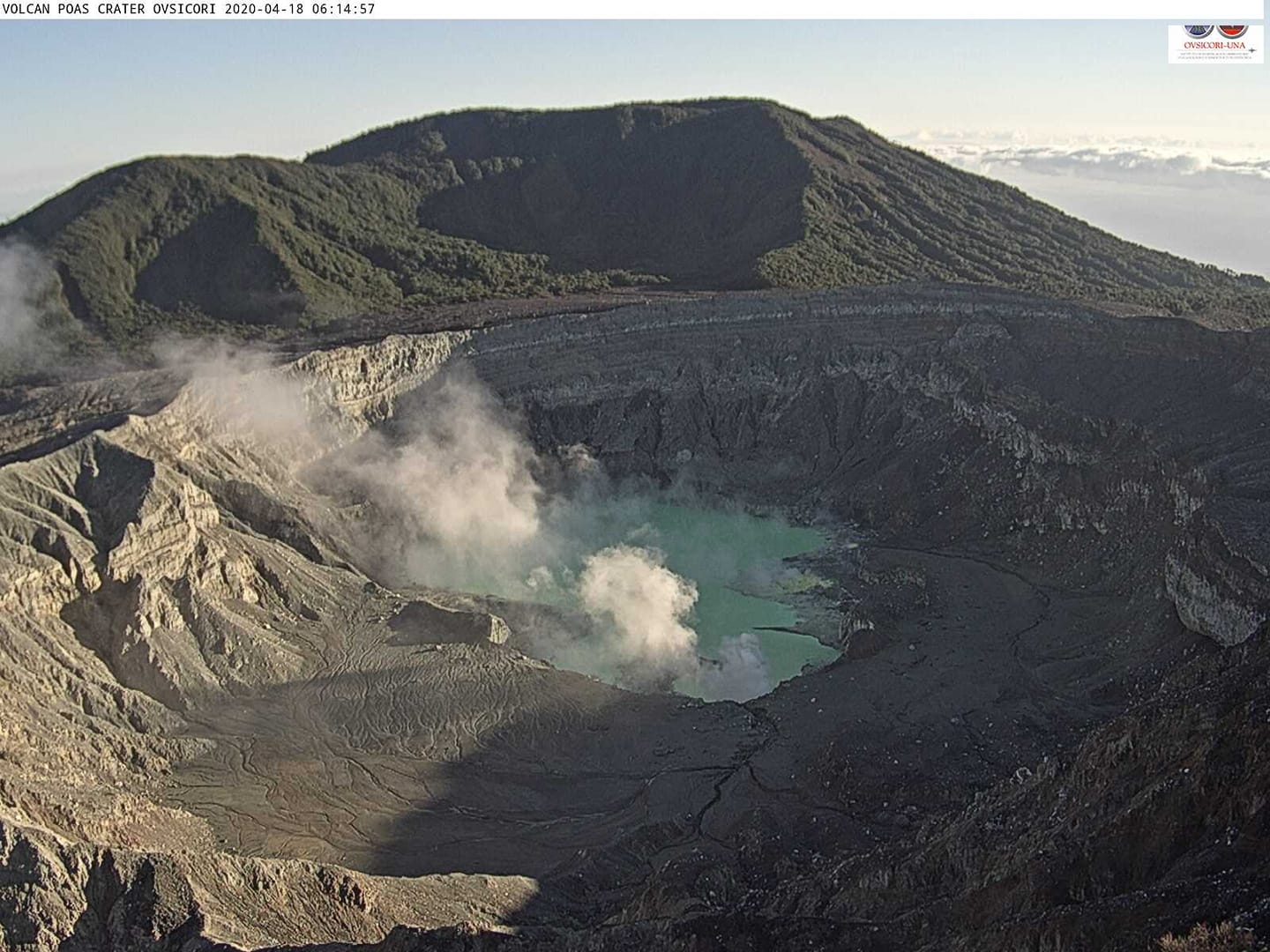
No eruption was detected. Incandescent episodes were observed on May 6 (4:00 am – 6:00 am local time) in the fumarole south of Boca A, possibly associated with spontaneous combustion of sulfur. Seismic activity remains stable around 200 to 300 daily events. Short superficial tremors of variable frequency, without periodicity, possibly associated with fumarolic activity, are recorded. Deformation monitoring shows a slight sag without significant horizontal movements. The SO 2 / CO 2 ratio is unstable with a slight downward trend, the H 2 S / SO 2 ratio remains stable with sporadic peaks. The flow of SO 2 is stable. Few peaks (up to 8 ppm) of SO 2 concentrations have been recorded at the national park level. The level of the lake seems stable.

Rincon de la Vieja volcano:

Lat: 10.83 ° N; Long: 85.324 ° W;
Altitude: 1895 m above sea level
Current activity level: 3 (erupting volcano)
Potentially associated hazards: gas, phreatic eruptions, proximal ballistic projections, lahars.

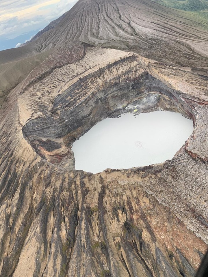
he activity of the volcano was maintained with frequent eruptions (seismic signal and infrasound) and exhalations (only infrasound signal) of variable amplitude. The eruptions were not large enough to generate lahars. The tremor is kept alternating between continuous and fragmented with sudden changes linked to the most important eruptions. LP type events and some VT type events continue to occur under the crater. There are 2 types of eruptive events: surface events and events with a deep explosion 30 to 120 seconds before the eruption. This activity has been stable since April 20. Geodetic measurements do not show significant deformation.

Activity report of the Rincón de la Vieja volcano, May 14, 2020.
On May 14, 2020 at 5:24 local time, an eruption was recorded on the Rincón de la Vieja volcano, with a column which rose 500 meters above the height of the crater and 2416 meters above from sea level. (7,924.48 ft).
Duration of activity: 1 minute.
No ash fall or sulfur odor reported
Comments: Small phreatic eruption observed by webcam.

Source : Ovsicori.

Photos : RSN , Cyrill Muller et Mario Angarita  , Theresa Lopez , Christopher Allen, Sunquest Helitours.

15 Mai 2020. FR . Colombie : Nevado del Ruiz , La Guadeloupe : La Soufrière , Equateur : Reventador , Costa Rica : Turrialba / Poas / Rincon de la Vieja .

15 Mai 2020.


Colombie , Nevado del Ruiz : 

Bulletin d’activité hebdomadaire du volcan Nevado del Ruiz

Le niveau d’activité se poursuit au niveau d’activité jaune ou (III): changements dans le comportement de l’activité volcanique.

Concernant le suivi de l’activité du volcan Nevado del Ruiz, le COLOMBIAN GEOLOGICAL SERVICE rapporte que:

Selon les résultats obtenus du suivi de l’activité, à travers les différents paramètres évalués, le volcan Nevado del Ruiz a continué à présenter une instabilité de son comportement au cours de la dernière semaine. Une accélération du processus volcanique et par conséquent des changements dans le niveau d’activité du volcan ne sont pas exclus.
La sismicité générée par la fracturation des roches a montré une légère diminution du nombre de tremblements de terre et de l’énergie sismique libérée, par rapport à la semaine précédente. Ce type de sismicité était principalement localisé dans le Sud-Est, le Sud-Sud-Est, le Nord-Est du volcan et dans le cratère Arenas, à des profondeurs variant entre 0,4 et 5,9 km. La magnitude maximale enregistrée au cours de la semaine était de 1,0 ML (magnitude locale) correspondant au tremblement de terre enregistré le 10 mai à 09h15 (heure locale) situé dans le cratère Arenas, à 1,6 km de profondeur.


La sismicité liée à la dynamique des fluides à l’intérieur des conduits volcaniques a présenté une légère diminution à la fois du nombre d’événements enregistrés et de l’énergie sismique libérée, par rapport à la semaine précédente. Cette activité sismique a été caractérisée par la survenue de tremors volcaniques continus, d’impulsions de tremor, de tremblements de terre de type longue période et de type très longue période. Ces événements sismiques ont présenté des niveaux d’énergie et des contenus spectraux variables. Certains de ces signes étaient associés à de petites émissions de gaz et de cendres, qui ont été confirmées par des caméras installées dans la zone du volcan et par des rapports des responsables du parc naturel national de Los Nevados.

La déformation de la surface volcanique, mesurée à partir des stations GNSS (Global Navigation Satellite System), a montré quelques changements mineurs, associés à l’activité volcanique. Au cours de la semaine dernière, les portails Web Mirova et NASA FIRMS n’ont signalé aucune anomalie thermique au volcan.

Le volcan Nevado del Ruiz continue à un niveau d’activité jaune.

Source et photo  : SGC.


La Guadeloupe , La Soufrière :

Depuis le début 2018 nous assistons à un processus cyclique d’injection de gaz magmatiques profonds à la base du système hydrothermal à une profondeur entre 2 et 3 km sous le sommet. Ceci engendre un processus récurrent de surchauffe et de surpression du système hydrothermal qui se traduit par:

1) des perturbations de la circulation des fluides hydrothermaux;
2) l’évolution de l’activité des fumerolles au sommet dont une témoigne de projection de boue brûlante et acide sur quelques mètres;
3) une augmentation de la sismicité volcanique en essaim;
4) quelques séismes volcaniques ressentis (quatre entre février et avril 2018) dont un séisme de magnitude M4.1 le 27 avril 2018, le plus fort depuis 1976;
5) des déformations de faible amplitude et limitées au dôme de La Soufrière de l’ordre de 3-7 mm/an et la poursuite de l’ouverture des fractures sommitales;
6) la fluctuation des débits du gaz fumerolien issus d’un réservoir hydrothermal pressurisé;
7) une progression des anomalies thermiques dans le sol au sommet de La Soufrière.

Si ces phénomènes incitent l’observatoire à la vigilance instrumentale, ils ne sont pour l’instant pas clairement associés à une anomalie des autres paramètres de surveillance qui pourrait indiquer une éventuelle remontée de magma. Cette dernière se manifesterait typiquement, mais pas systématiquement, par de nombreux séismes profonds et/ou ressentis, des déformations à grande échelle au delà du dôme, et l’émission de gaz soufrés à haute température (> 150°C). Sur la base des observations de l’OVSG-IPGP enregistrées au cours du mois d’avril 2020 et résumées dans ce bulletin, et en accord avec les dispositions prévues par les autorités, le niveau d’alerte volcanique (tableau en annexe) reste:

La probabilité d’une activité éruptive à court terme reste faible. Cependant, compte tenu du regain d’activité sismique et fumerolienne enregistré depuis février 2018, un changement de régime du volcan a été constaté tel qu’on ne puisse pas exclure une intensification des phénomènes dans le futur. En conséquence, l’OVSG-IPGP est en état de vigilance renforcée. Les émanations gazeuses aux abords et sous le vent des fumerolles principales du sommet (notamment le Cratère Sud, le Tarissan, et le Gouffre 1956) présentent, depuis 1998, des risques avérés d’irritation et de brûlures (yeux, peau, voies respiratoires).

Compte tenu de l’évolution décrite ci-dessus et des autres observations sur l’activité, l’OVSGIPGP considère qu’il est important de garder, à titre précautionneux, une distance de au moins 50 m de rayon autour des principaux centres d’émission de gaz fumerolien (Cratère Sud , Cratère Sud Central, Cratère Sud Nord, Napoléon Nord, Napoléon Est, Gouffre 1956, Gouffre Tarissan). En considération de l’évolution de la zone d’anomalie au sommet (avec la propagation de chaleur au sol; la recrudescence de l’activité des fumerolles, accompagnée de l’apparition dans le temps de nouveaux centres d’émission et de projection de boue et de fragments; les indications de l’impact au sol et sur la végétation de gaz soufrés et acides) et donc d’une général augmentation des zones d’instabilité, la Préfecture de Guadeloupe avec l’arrêté n° 2019/001 CAB SIDPC du 14 janvier 2019 a institué un accès réglementé au sommet du volcan de la Soufrière, basé sur l’identification d’un périmètre de sécurité et sur l’interdiction à toute personne non-autorisée de le franchir.

Source : IPGP.

Lire l’article en entierhttp://volcano.ipgp.fr/guadeloupe/Bulletins/last_bulletins.pdf

Photos : A.-Brusini-hemis-fr , F. BEAUDUCEL/IPGP 2010 .


Equateur , Reventador :

RAPPORT QUOTIDIEN DE L’ETAT DU VOLCAN REVENTADOR , Jeudi 14 Mai 2020.
Information Geophysical Institute – EPN.

Niveau d’activité Superficiel: Haut , Tendance de surface : Pas de changement .
Niveau d’activité interne: Haut , Tendance interne : Pas de changement.

Sismicité : Du 13 Mai 2020, 11:00h au 14 Mai 2020, 11:00h :
Type Longue Période (LP): 19 événements
Explosions (EXP): 22 événements
Tremors d’émissions : (TE): 6.
Tremors harmoniques : (TA): 2.

Pluies / lahars: Non enregistrés.

Emission / colonne de cendres: Des émissions de vapeur, de gaz et de cendres ont été observées en direction Ouest, qui dépassaient 1000 m au-dessus du niveau du cratère. Dans les images satellite partagées par le VAAC, 3 alertes d’émission ont été signalées dans une direction Ouest, avec une hauteur maximale de 2538 m au-dessus du sommet

Autres paramètres de surveillance: aucun changement.

Observations: Émissions de gaz et de cendres la nuit et matin, signalées par les alertes VAAC et les caméras visuelles. Pendant la nuit, une incandescence a été observée au niveau du sommet, accompagnée de la descente de blocs incandescents sur le flanc Sud-Est à 300 m sous le cratère. Secteur nuageux en ce moment.

Niveau d’alerte: Orange.

Source : IGEPN.

Photo : alex-steele-via-fb 


Costa Rica , Turrialba / Poas / Rincon de la Vieja :

Bulletin hebdomadaire du programme de surveillance volcanique , 11 mai 2020 .

Volcan Turrialba:

Lat: 10,025 ° N; Long: 83 767 ° O;  
Altitude : 3340 m d’altitude
Niveau d’activité actuel: 2 (volcan actif)
Dangers potentiellement associés: gaz, émission de cendres, projections balistiques proximales .

Orthophotographie du volcan Turrialba, résultat du vol avec drone du 6 février 2020, réalisé par Cyrill Muller et Mario Angarita du département de géodésie de l’OVSICORI-UNA.
Une orthophotographie est obtenue par un ensemble d’images aériennes, qui ont été corrigées pour représenter une projection orthogonale sans effet de perspective, et dans laquelle il est donc possible de procéder à des mesures précises.

Aucune émission de cendres n’a été détectée. La sismicité reste stable. La tendance à la contraction et à l’affaissement du massif du Turrialba-Irazú se poursuit, en particulier vers l’Irazú et le sommet du Turrialba. Les ratios CO 2 / SO 2 et H 2 S / SO 2 continuent d’augmenter depuis la mi-mars, le flux de SO 2 reste stable.

Volcan Poas:

Lat: 10,2 ° N; Long: 84,233 ° O;
Altitude : 2780 m d’altitude
Niveau d’activité actuel: 2 (volcan actif)
Dangers potentiellement associés: gaz, éruptions d’eau souterraine, projections balistiques proximales .

Aucune éruption n’a été détectée. Des épisodes incandescents ont été observés le 6 mai (4h00 – 6h00 heure locale) dans la fumerolle au sud de Boca A, possiblement associés à une combustion spontanée de soufre. L’activité sismique reste stable autour de 200 à 300 événements quotidiens. De courts tremors superficiels de fréquence variable, sans périodicité, éventuellement associés à une activité fumerolienne, sont enregistrés. La surveillance de la déformation montre un léger affaissement sans mouvements horizontaux significatifs. Le rapport SO 2 / CO 2 est instable avec une légère tendance à la baisse, le rapport H 2 S / SO 2 reste stable avec des pics sporadiques. Le flux de SO 2 est stable. Peu de pics (jusqu’à 8 ppm) de concentrations de SO 2 ont été enregistrés au niveau du point de vue du parc national. Le niveau du lac semble stable.

Volcan Rincon de la Vieja :

Lat: 10,83 ° N; Long: 85,324 ° O; 
Altitude : 1895 m d’altitude
Niveau d’activité actuel: 3 (volcan en éruption)
Dangers potentiellement associés: gaz, éruptions phréatiques, projections balistiques proximales , lahars.

L’activité du volcan s’est maintenue avec des éruptions fréquentes (signal sismique et infrason) et des exhalations (uniquement signal infrason) d’amplitude variable. Les éruptions n’étaient pas assez importantes pour générer des lahars. Le tremor est maintenu alternant entre continu et fragmenté avec des changements soudains liés aux éruptions les plus importantes. Des évènements de type LP et quelques évènements de type VT continuent de se produire sous le cratère. On observe 2 types d’événements éruptifs: des événements de surface et des événements avec une explosion profonde 30 à 120 secondes avant l’éruption. Cette activité est stable depuis le 20 avril. Les mesures géodésiques ne montrent pas de déformation significative.

Rapport d’activité du volcan Rincón de la Vieja , 14 Mai 2020.
Le 14 Mai 2020 à 5:24 heure locale, une éruption a été enregistrée sur le volcan Rincón de la Vieja, avec une colonne qui s’est élevée à 500 mètres au-dessus de la hauteur du cratère et à 2416 mètres au-dessus du niveau de la mer. (7924,48 pi).
Durée de l’activité: 1 minute.

Aucune chute de cendres ni odeur de soufre rapportée
Commentaires: Petite éruption phréatique observée par webcam.

Source : Ovsicori.

Photos : RSN , Cyrill Muller et Mario Angarita  , Theresa Lopez , Christopher Allen, Sunquest Helitours.