
March 05 , 2020.
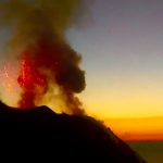
Italy , Stromboli :
Weekly bulletin from 24/02/2020 to 01/03/2020 (issue date 03/03/2020)
SUMMARY OF ACTIVITY STATUS
In light of the monitoring data, it is highlighted:
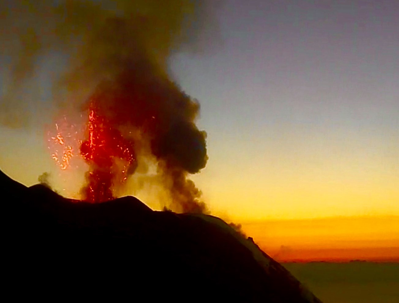
1) VOLCANOLOGICAL OBSERVATIONS: During this period, a normal explosive activity of strombolian type was observed accompanied by degassing activities. The hourly frequency of explosions fluctuated between average values (11 events / h on February 26) and medium-high values (17 events / h on February 24). The intensity of the explosions was mainly average in the area of the North crater and in the area of the Center-South crater.
2) SEISMOLOGY: The seismological parameters do not show significant variations.
4) DEFORMATIONS: Stromboli soil deformation monitoring networks did not show any significant variation to report for the period considered.
5) GEOCHEMISTRY: The flow of SO2 is at an average level. The CO2 / SO2 ratio is at an average value (last update on 02/09/2020). The isotopic ratio of dissolved helium in the aquifer is at low-medium levels.
VOLCANOLOGICAL OBSERVATIONS.
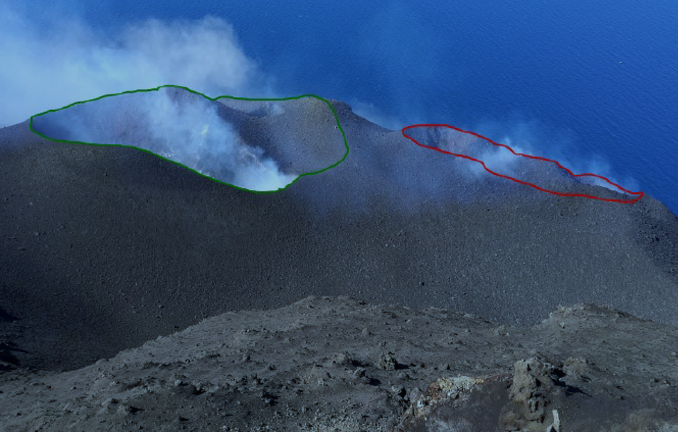
The analysis of the images recorded by the cameras placed at an altitude of 400 m, at an altitude of 190 m and at Punta dei Corvi made it possible to characterize the eruptive activity of Stromboli. During the reporting period, the explosive activity was mainly produced by at least 3 (three) eruptive vents located in the area of the North crater and by at least 3 (three) eruptive vents located in the area of the Center-South crater . All the vents are located inside the depression which occupies the crater terrace.
In the northern zone, the explosions were mainly of variable intensity, from low (less than 80 m in height) to high (more than 150 m in height), emitting coarse materials (lapilli and bombs). In numerous explosions, the abundant fallout covered the outer slopes of the area overlooking the Sciara del fuoco and the blocks rolled until they reached the coast. The average frequency of explosions in the North zone varied between 7 and 10 events / h. The explosive activity of the Center-South zone produced explosions of mainly fine materials (ash) sometimes mixed with coarse materials of medium intensity (less than 150 m in height). The frequency of explosions in the Center-South zone varied between 2 and 9 events / h.
The amplitude of the volcanic tremor generally had medium-low values. The peak of the medium-high values visible on the graphs of 02/27 was due to bad weather and sea conditions.
Source : INGV Vulcani .
Read the article : file:///C:/Users/Utilisateur/AppData/Local/Packages/Microsoft.MicrosoftEdge_8wekyb3d8bbwe/TempState/Downloads/BollettinoStromboli20200303%20(1).pdf
Colombia , Galeras :
Weekly bulletin of the Galeras volcano.
The activity of the volcano continues at the YELLOW LEVEL ■ (III): CHANGES IN THE BEHAVIOR OF VOLCANIC ACTIVITY.
Following the activity of the VOLCÁN GALERAS, the COLOMBIAN GEOLOGICAL SERVICE (SGC) reports that:
In low levels, during the period evaluated between February 25 and March 2, 2020, seismic activity experienced a slight increase in both occurrence and released energy, maintaining the predominance of earthquakes associated with fracture of cortical material inside the volcanic building, some of which were scattered in the area of volcanic influence, at distances less than 15 km from the summit of Galeras, with depths up to 10 km below its summit and with a maximum local magnitude of 2.4. The earthquake recorded on March 1 at 7.20 am is highlighted, located 5.5 km southeast, at a depth of 4.6 km and magnitude 2.4 and which was reported as felt by the inhabitants from the municipality of Pasto.
Favorable weather conditions enabled, during all days of the week, the observation of gas emissions from the main crater and the fumarole fields of the periphery of the active cone, at Las Chavas in the West and El Paisita in the North, mainly, with white columns of low height and with variable dispersion according to the wind. The other geophysical and geochemical monitoring parameters of the Galeras volcano did not show any significant change.
Source et photo : SGC.
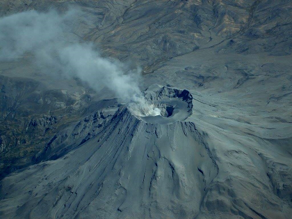
Indonesia , Semeru :
VOLCANO OBSERVATORY NOTICE FOR AVIATION – VONA.
Issued: March 05 , 2020
Volcano: Semeru (263300)
Current Aviation Colour Code: ORANGE
Previous Aviation Colour Code: orange
Source: Semeru Volcano Observatory
Notice Number: 2020SMR17
Volcano Location: S 08 deg 06 min 29 sec E 112 deg 55 min 12 sec
Area: East java, Indonesia
Summit Elevation: 11763 FT (3676 M)
Volcanic Activity Summary:
Eruption with volcanic ash cloud at 00h40 UTC (07h40 local).
Volcanic Cloud Height:
Best estimate of ash-cloud top is around 12403 FT (3876 M) above sea level, may be higher than what can be observed clearly. Source of height data: ground observer.
Other Volcanic Cloud Information:
Ash cloud moving to west
Remarks:
Seismic activity is characterized by eruption, avalanche and gas emission earthquakes.
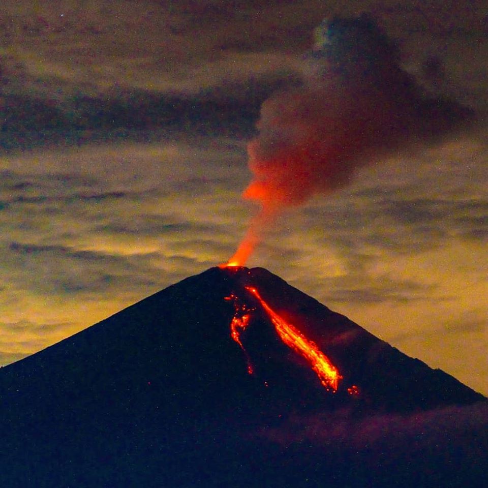
Level of activity at level II (WASPADA). G. Semeru (3,676 m above sea level) is experiencing a continuous eruption. The last eruption occurred on March 4, 2020 with a height of the eruption column not observed.
The volcano is clearly visible until it is covered with fog. The smoke from the crater is observed with a thin white column, about 50-100 meters high above the summit. The weather is sunny / rainy, the winds are light to moderate to the North, North-East, South and West. The temperature is around 22-28 ° C.
6 eruptions were observed with strong smoke from 100 to 200 m above sea level, their color was white, thick, facing north.
Avalanches of the flow front were observed 16 times with a sliding distance of 300 to 1000 m from the tip of the lava tongue (kl. 750 m from the crater) towards the Twin Besuk, Besuk Bang and Besuk Kobokan. At night, when the mountain is clear, it is observed, a glow from a height of 10 -50 m.
According to the seismographs of March 4, 2020, it was recorded:
61 exploding earthquakes / eruption earthquakes
1 emission earthquake
1 hot avalanche earthquake.
Recommendation:
The community must not carry out activities within a radius of 1 km and in the area up to 4 km in the sector of the South-Southeast slopes of the active crater which is an opening area of the active crater of G. Semeru (Jongring Seloko) as a channel for sliding warm clouds.
Source : Magma Indonésie , PVMBG.
Vidéo : Peter Rendez Vous .
Photo : @visit.pronojiwo via Sherine France .
Japan , Nishinoshima :
27.247°N, 140.874°E
Elevation 25 m
The Japan Coast Guard (JCG) presented InSAR results from 17 November 2019 to 28 February 2020 showing growth of Nishinoshima’s central cone alomg with changes to the island’s surface and expansion of the coastline from lava flows.
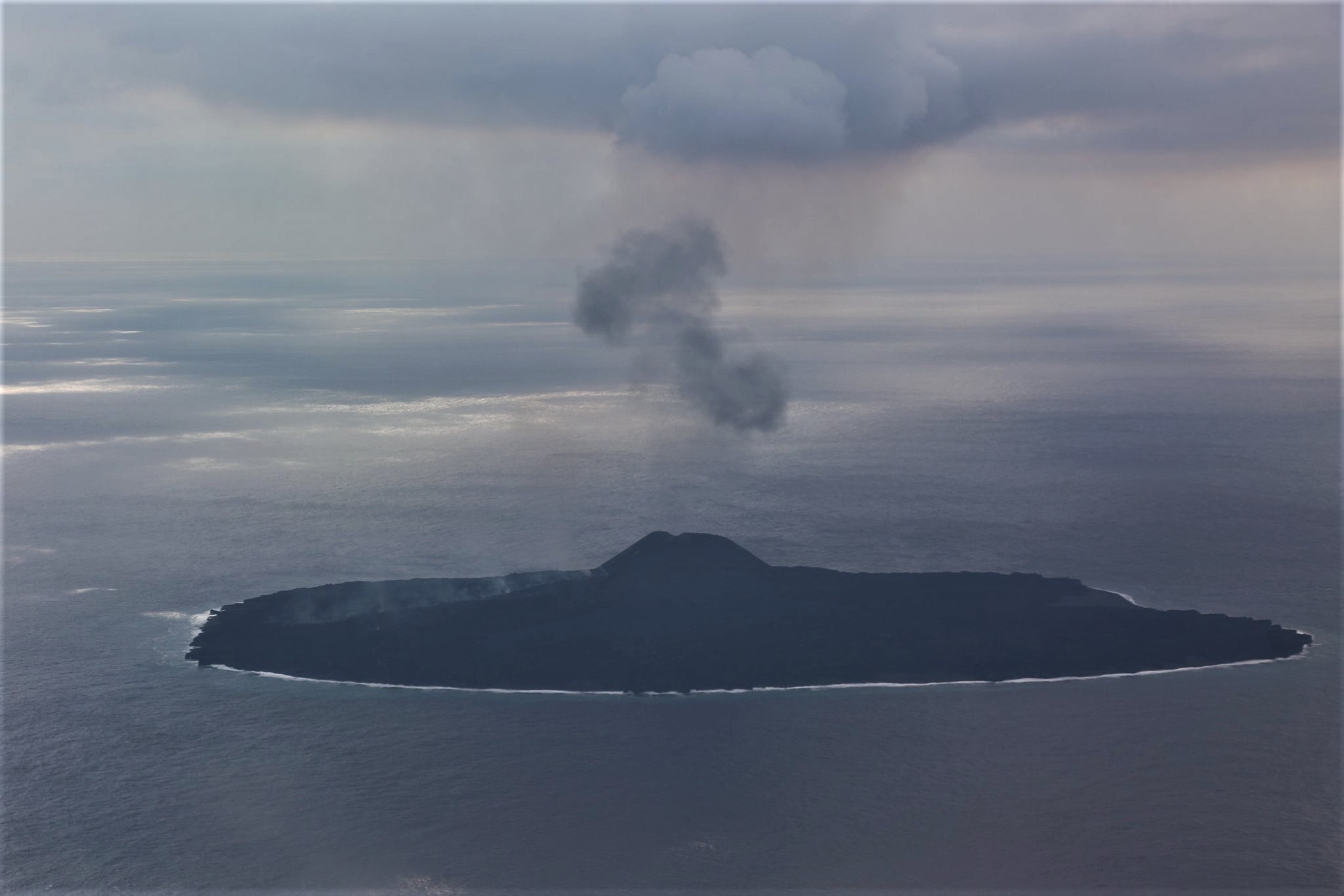
During an overflight on 17 February observers noted continuous activity from the central vent, including a diffuse ash plume rising about 600 m. Ejected material landed near the cone’s base. Lava flowed into the sea at the N and E coasts, causing a rising steam plume. Discolored water had been seen on 4 February in an area 9 km S of the island but was not apparent during the overflight possibly due to weather conditions. The marine exclusion zone was defined as a radius of about 2.6 km from the island.
Source: Japan Coast Guard, GVP .
Peru , Ubinas :
Analysis period: February 24 to March 1, 2020 Arequipa, March 2, 2020
Alert level: ORANGE
The Geophysical Institute of Peru (IGP) reports that the eruptive activity of the Ubinas volcano remains at low levels. To date, the recording of earthquakes associated with the rise of magma to the surface is rare. There are weak and sporadic emissions of bluish gases (of magmatic origin) and water vapor. According to this scenario, the possibility of volcanic explosions and / or ash emissions is low.
The IGP recorded and analyzed a total of 125 seismic events associated with the dynamic behavior of the Ubinas volcano, with the predominance of Volcano-Tectonic (VT) type seismic signals, related to the fracturing of rocks inside the volcano. On average, there were 9 earthquakes per day with magnitudes below M1.8. The seismic activity linked to the rise of magma (hybrid type) decreased both in the number of events (3 daily earthquakes) and in its energy.
Surveillance cameras recorded light and sporadic emissions of blue gases (of magmatic origin) and water vapor with heights less than 170 m above the summit of the volcano. Monitoring the deformation of the volcanic structure does not record any significant anomalies. MIROVA satellite surveillance did not record any thermal anomalies.
On February 29 at 3:25 p.m. and 5:00 p.m. and on March 1 at 4:01 p.m., the IGP recorded and reported the descent of 3 lahars (volcanic mud flow) via the Volcanes Peru mobile application in the Volcanmayo gorges and in the Sacohaya river. The events presented volumes considered moderate to high, with an impact on the communication routes and agricultural land in the district of Ubinas.
Source : IGP.
Photo : Auteur Inconnu .


No comment yet, add your voice below!