
January 31 , 2020.
Philippines , Taal :
TAAL VOLCANO BULLETIN 31 January 2020 8:00 A.M.
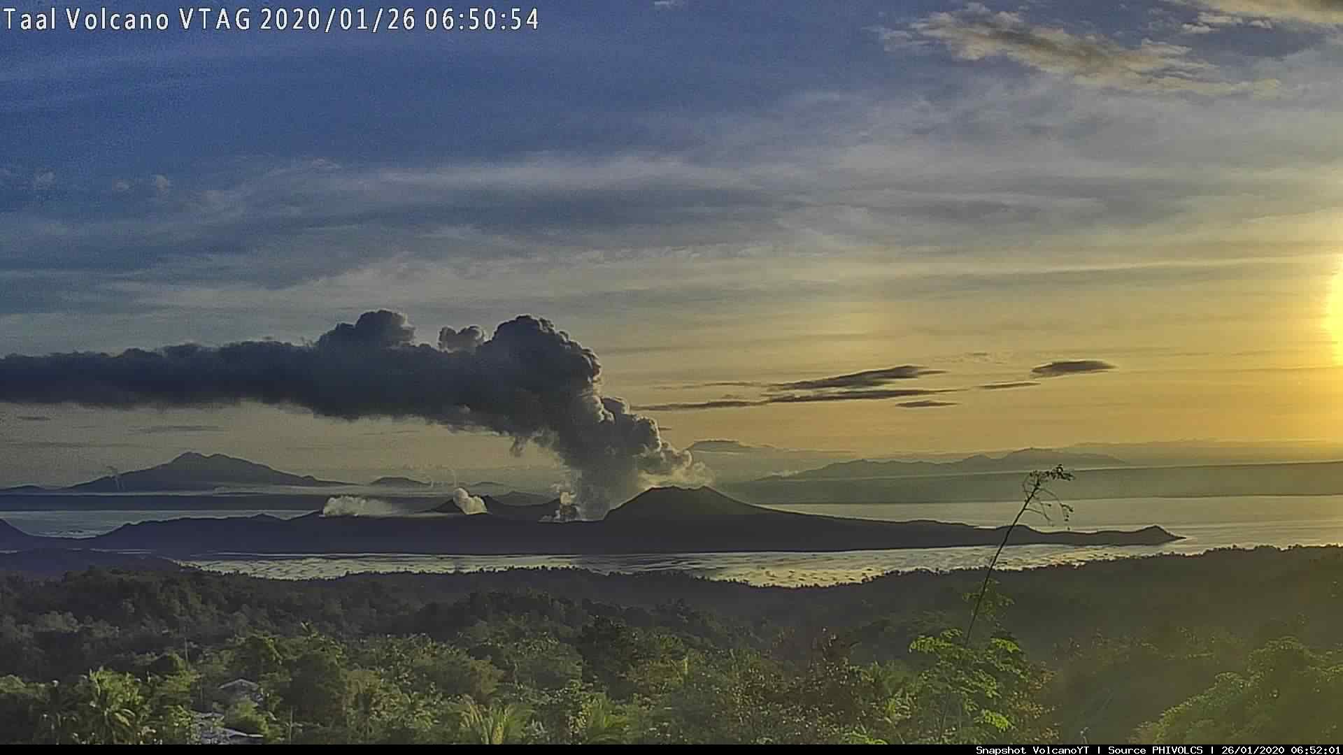
Activity in the Main Crater in the past 24 hours has been characterized by moderate emission of white to dirty white steam-laden plumes 500-700 meters tall that drifted southwest. Sulfur dioxide (SO2) emission was below instrumental detection.
The Philippine Seismic Network (PSN) plotted a total of seven hundred sixty-three (763) volcanic earthquakes since 1:00 PM, January 12, 2020. One hundred seventy-seven (177) of these registered at magnitudes M1.2-M4.1 and were felt at Intensities I-V. Since 5:00 AM on January 29, 2020 until 5:00 AM today, there were seven (7) volcanic earthquakes plotted that registered at magnitudes M1.7-M2.5 with no felt event.
For the past 24 hours, the Taal Volcano Network, which can record small earthquakes undetectable by the PSN, recorded one hundred sixteen (116) volcanic earthquakes including two (2) low-frequency events. These earthquakes signify magmatic activity beneath the Taal edifice that could lead to eruptive activity at the Main Crater.
Alert Level 3 is maintained over Taal Volcano. DOST-PHIVOLCS reminds the public that sudden steam-driven and even weak phreatomagmatic explosions, volcanic earthquakes, ashfall, and lethal volcanic gas expulsions can still occur and threaten areas within Taal Volcano Island and nearby lakeshores. DOST-PHIVOLCS recommends that entry into the Taal Volcano Island as well as into areas over Taal Lake and communities west of the island within a seven (7) km radius from the Main Crater must be strictly prohibited. Local government units are advised to assess areas outside the seven-kilometer radius for damages and road accessibilities and to strengthen preparedness, contingency and communication measures in case of renewed unrest. People are also advised to observe precautions due to ground displacement across fissures, frequent ashfall and minor earthquakes. Communities beside active river channels particularly where ash from the main eruption phase has been thickly deposited should increase vigilance when there is heavy and prolonged rainfall since the ash can be washed away and form lahars along the channels. Civil aviation authorities must advise pilots to avoid flying close to the volcano as airborne ash and ballistic fragments from sudden explosions and wind-remobilized ash may pose hazards to aircrafts.
DOST-PHIVOLCS is closely monitoring Taal Volcano’s activity and any new significant development will be immediately communicated to all stakeholders.
Source : Phivolcs .
Photo : Archives Phivolcs.
Chile , Nevados of Chillan :
Special volcanic activity report (REAV) Ñuble Region, Nevados de Chillán Volcanic Complex, January 30, 2020, 4:00 p.m. Local time (mainland Chile).
The National Geological and Mining Service of Chile (Sernageomin) discloses the following PRELIMINARY information, obtained with the monitoring equipment of the National Volcanic Monitoring Network (RNVV), processed and analyzed at the Andes del Volcanological Observatory South (OVDAS):
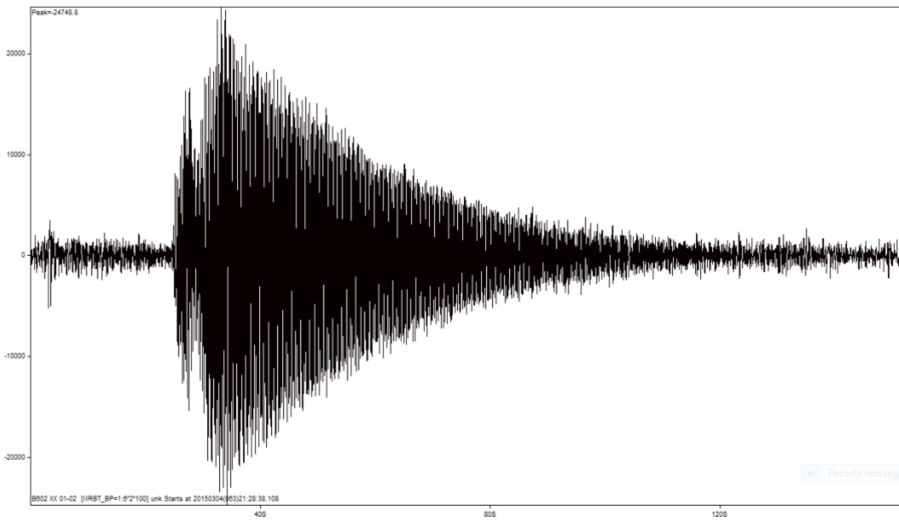
On Thursday January 30, at 3:45 p.m. local time (6:45 p.m. UTC), the monitoring stations installed near the Nevados de Chillán Volcanic Complex recorded a volcano-tectonic earthquake (VT), associated with a material fracture rigid inside the volcanic building, 2.1 km west – north-west of the Nicanor crater.
The characteristics of the earthquake are as follows:
TIME OF ORIGIN: 3:45 p.m. local time (6:45 p.m. UTC)
LATITUDE: 36 862 ° S LONGITUDE: 71 401 ° W
DEPTH: 3.8 km
LOCAL MAGNITUDE: 3.6.
At 13:56 local time (16:56 UTC), surveillance cameras installed in the immediate vicinity of the Volcanic Complex of Nevados de Chillán recorded an emission of gas with particulate matter with a height of approximately 3.4 km, compared to the active crater . Associated with this, a long period low energy type seismic signal was recorded with a reduced displacement of 90 cm2.
OBSERVATIONS:
No change in surface activity was associated with the described seismic event. At the time of publication of this report, seismicity continues, albeit with less energy.
The volcanic technical alert is maintained at the level: Orange level.
Source : Sernageomin.
Costa Rica , Rincon de la Vieja :
Lat: 10.83 ° N; Long: 85.324 ° W;
Height: 1895m
Current activity level: 3 (volcanic eruption)
Potentially associated hazards: gas, phreatic eruptions, proximal ballistic projections, lahars. The last phreatic eruption was recorded on January 2 at 11:18 p.m. The seismicity has increased: the background tremor has been amplified, the frequency of short tremors has intensified with several swarms.
Two « Tornillo » type events were recorded with the hydrothermal system signed. There is no significant deformation, but a tendency for the volcanic building to contract. The activity level of the volcano is raised to 3 since the possibility of eruptions has considerably increased.
Activity report of the Rincon de la Vieja volcano, January 30, 2020.
On January 30, 2020 at 12:13 local time, an eruption was recorded on the Rincón de la Vieja volcano, with a column that rises to 2000 meters above the height of the crater and 3916 m above sea level. (meters above sea level) (12844.48 ft).
Duration of the activity: in progress.
Ash fall reported in: No ash fall reported
Sulfur odor reported in: No sulfur odor is reported
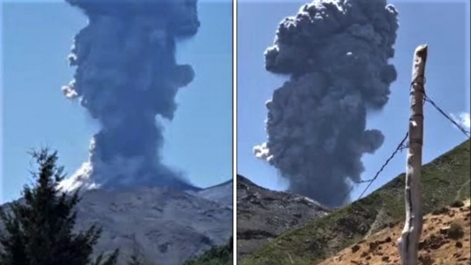
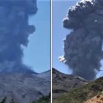
At 12:13 p.m. on January 30, a phreatic eruption occurred on the Rincon de La Vieja volcano. Pyroclastic flows and hot lahars were generated. It is recommended that people stay away from rivers in the region and remain vigilant. In this video from the RSN surveillance camera, the eruption is observed and later, a video of a neighbor from the region where he filmed a lahar in the Penjamo river.
Report: Dr. Paulo Ruiz.
The Rincon de la Vieja volcano, located in the province of Guanacaste, has shown an increase in activity in recent days. The most recent was an eruption of expelled ash type and phreatic blocks. The column vapor emanating from the solid reached 2,000 meters above the crater and lasted between 10 and 15 seconds.
This eruption caused the descent of pyroclastic flows (dense and hot ash clouds) along the northern flank of the volcano, which, when channeled through the channels of the tributaries, generated currents of mud (lahars) at across the Pénjamo, Zanjonuda and Azufrosa streams, also known as Azufrada. In addition, a large plume of gas was observed visible in several areas near the volcano.
According to Guillermo Alvarado Induni, a graduate professor of geology from the University of Costa Rica (UCR) and volcanologist of the National Commission for Prevention and Emergency Risk Response (CNE), this eruption is completely normal for a active volcano.
Source : Ovsicori , RSN .
Photos : RSN , Juan Carlos López del ICE.
Vidéo : RSN.
Hawaii , Mauna Loa :
19°28’30 » N 155°36’29 » W,
Summit Elevation 13681 ft (4170 m)
Current Volcano Alert Level: ADVISORY
Current Aviation Color Code: YELLOW
Activity Summary:
Mauna Loa Volcano is not erupting. Rates of deformation and seismicity have not changed significantly over the past week and remain above long-term background levels.
Observations:
During the past week, HVO seismometers recorded 107 small magnitude earthquakes beneath the upper elevations of the volcano; the strongest was a magnitude-2.3 earthquake on January 23. Most earthquakes occurred at shallow depths of less than 5 km (~3 miles) beneath the volcano’s surface.
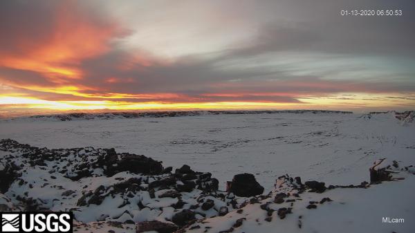
Snow at the summit of Mauna Loa has been visible over the past few days in HVO’s MLcam, a webcam on the northeastern rim of Moku‘āweoweo, the volcano’s summit caldera.
Global Positioning System (GPS) measurements show continued slow summit inflation, consistent with magma supply to the volcano’s shallow storage system.
Gas concentrations at the Sulphur Cone monitoring site on the Southwest Rift Zone remain stable. Fumarole temperatures as measured at both Sulphur Cone and the summit have not changed significantly.
A Magnitude 3.8 earthquake struck 9 miles southwest of Leilani Estates on Wednesday at around 12:23 p.m.
The event was not strong enough to cause a tsunami, emergency officials reported.
Source : HVO. Big Island Video News .
Iceland , Mt Thorbjorn :
There is no indication of magma having accumulated near the surface of the earth in the vicinity of Grindavík, Southwest Iceland, mbl.is reports. This is the result of gas measurements done near Þorbjörn mountain by specialists from the Icelandic Met Office, in cooperation with staff from HS-Orka energy company.
The analysis of water samples shows the same result. Monitoring of the area by the Icelandic Met Office furthermore reveals that inflation near Þorbjörn mountain, which had amounted to 3-4 mm a day since January 21, has slowed down considerably.
Seismic activity, though, increased yesterday morning, with two earthquakes in excess of magnitude 3 hitting the area between 4 and 5 am, followed by a tremor of magnitude 2.7 shortly before 4 pm yesterday.
As a precautionary measure, should evacuation be needed, the Icelandic Road Administration has increased service of roads from the town of Grindavík, located just south of Þorbjörn mountain. Suðurstrandarvegur road, which stretches eastward along the south coast to Þorlákshöfn, and Nesvegur road, along the south coast to the west, will now be ploughed or salted, if needed, seven days a week.
Source : icelandmonitor.mbl.is . https://icelandmonitor.mbl.is/news/nature_and_travel/2020/01/30/measurements_show_no_magma_near_surface/?fbclid=IwAR1_NBrk4g5OR4y5gh6cidb73wOi4dtVU1fYfirdtELx8zImjk5XLSZu650


No comment yet, add your voice below!