
January 15 , 2020 .
Philippines , Taal :
TAAL VOLCANO BULLETIN: 15 January 2020 8:00 A.M.
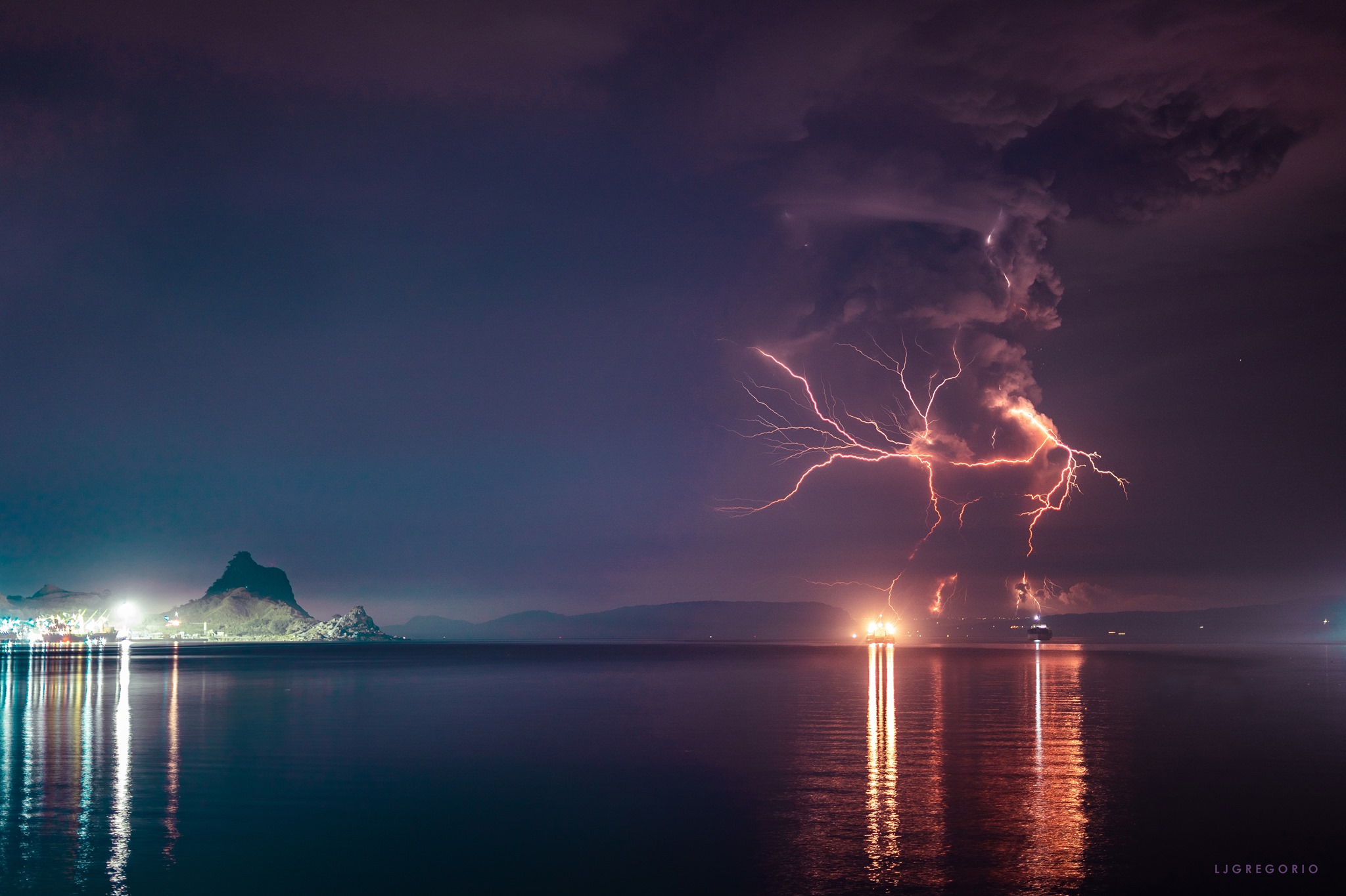
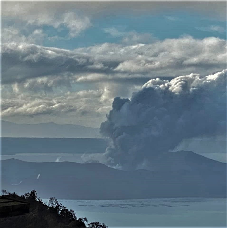
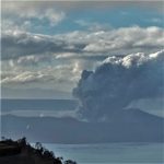
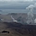
For the past 24 hours, Taal Volcano’s activity has been characterized by continuous but generally weaker eruption of the Main Crater due to magmatic and hydrovolcanic processes. This ongoing eruption generated dark gray steam-laden plumes that reached approximately 1000 meters high and dispersed ash to the southwest of the Main Crater.
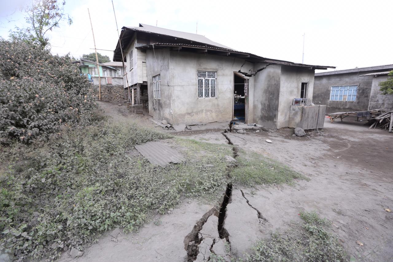
New fissures or cracks were observed in Sinisian, Mahabang Dahilig, Dayapan, Palanas, Sangalang, Poblacion, Mataas na Bayan, Lemery; Pansipit, Bilibinwang, Agoncillo; Poblacion 1, Poblacion 2, Poblacion 3, Poblacion 5, Talisay and Poblacion, San Nicolas. A fissure transected the road connecting Agoncillo to Laurel, Batangas.
The Philippine Seismic Network plotted a total of four hundred sixty-six (466) volcanic earthquakes since 1:00 PM, January 12, 2020. One hundred fifty-six (156) of these were felt with intensities ranging from Intensity I – V. Since 5:00 AM on January 14, 2020 until 5:00 AM today, there were one hundred fifty-nine (159) volcanic earthquakes and twenty-eight (28) of which were felt with intensities ranging from Intensity I – III. Such intense seismic activity probably signifies continuous magmatic intrusion beneath the Taal edifice, which may lead to further eruptive activity.
Sulfur dioxide (SO2) emission was measured at an average of 1686 tonnes/day on 14 January 2020.
Alert Level 4 still remains in effect over Taal Volcano. This means that hazardous explosive eruption is possible within hours to days. DOST-PHIVOLCS strongly reiterates total evacuation of Taal Volcano Island and high-risk areas as identified in the hazard maps within the 14-km radius from Taal Main Crater and along the Pansipit River Valley where fissuring has been observed.
Residents around Taal Volcano are advised to guard against the effects of heavy and prolonged ashfall. Civil aviation authorities must advise pilots to avoid the airspace around Taal Volcano as airborne ash and ballistic fragments from the eruption column pose hazards to aircraft. DOST-PHIVOLCS is continually monitoring the eruption and will update all stakeholders of further developments.
Source : Phivolcs .
Photos : LJ Gregorio , kim m badbadon , manilla bulletin .
Italy / Sicily , Etna :
Weekly bulletin 06/01/2020 – 12/01/2020 (date of issue 14/01/2020)
SUMMARY OF THE STATUS OF THE ACTIVITY
In light of the monitoring data, it is underlined:
1) VOLCANOLOGICAL OBSERVATIONS: Strombolian intra-crater activity and ash emissions from Voragine, the New South-East Crater and the North-East Crater.
2) SEISMOLOGY: Modest seismic fracturing activity; modest increase in volcanic tremors parameters.
3) INFRASOUND: Moderate infrasonic activity.
4) DEFORMATIONS: There is a slight decrease in the rate of inflation of the volcanic building, associated with an acceleration towards the east of the eastern slope.
5) GEOCHEMISTRY: the fluxes of SO2 and HCl are at a medium-low level. The flow of CO2 towards the ground shows a slight decrease compared to the previous week, settling on medium-low values. The partial pressure of CO2 in the aquifer does not show significant variations. The isotopic ratio of helium is at medium-high values (last data available on 07/01/2020).
VOLCANOLOGICAL OBSERVATIONS.
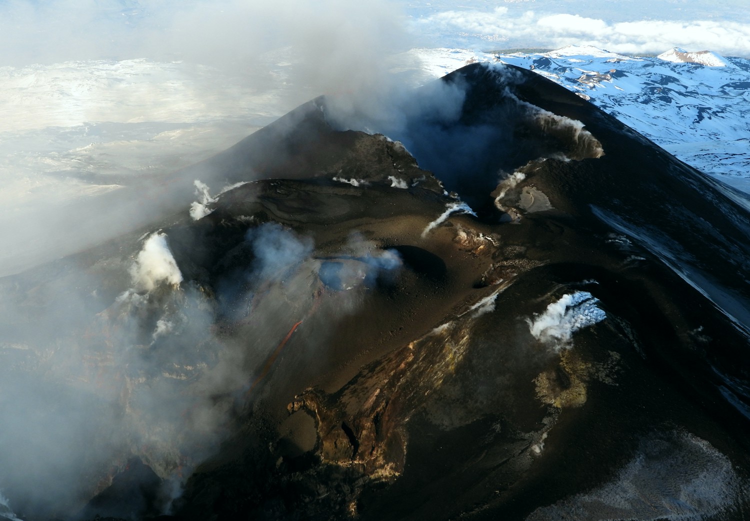
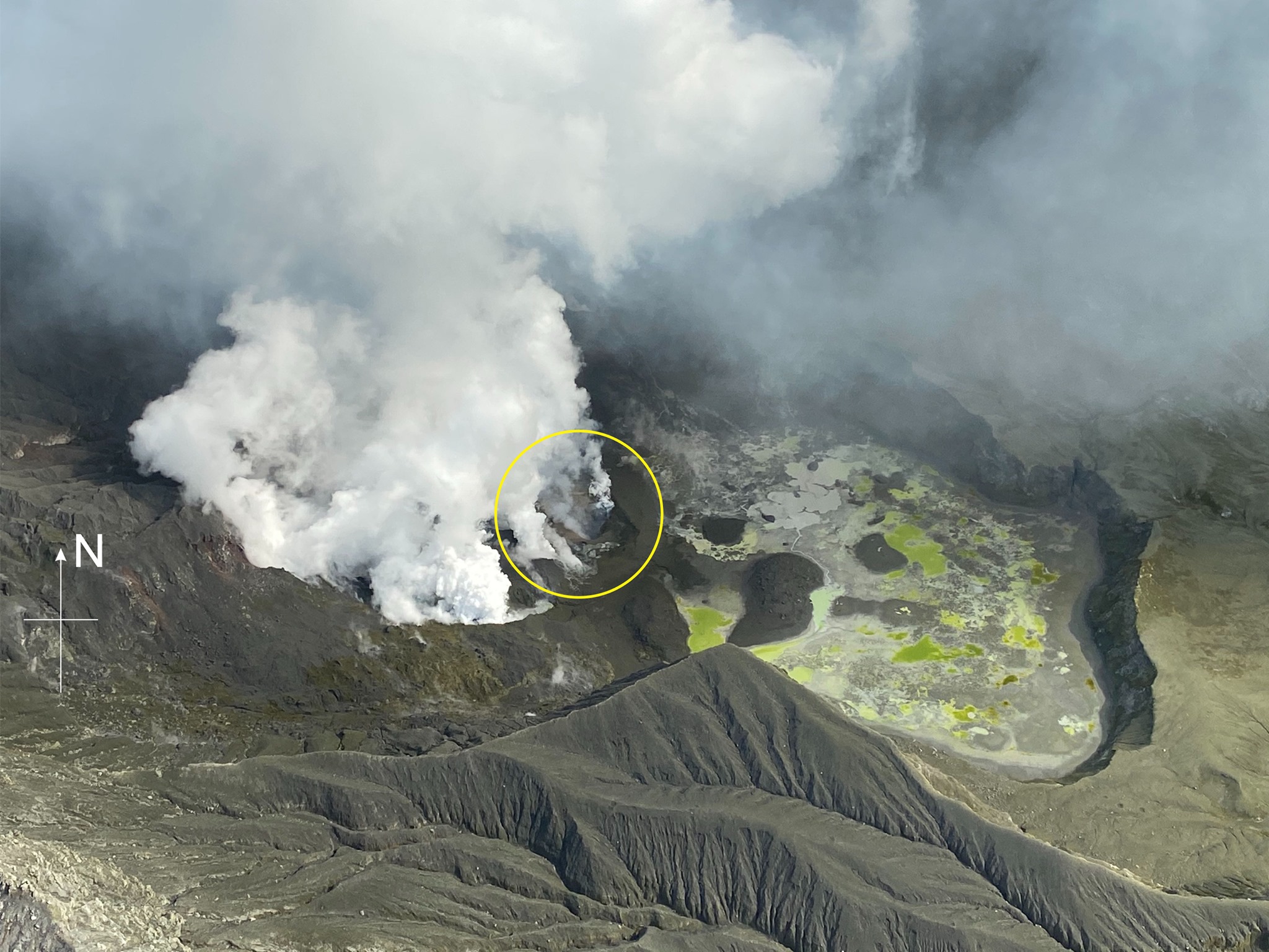
During the week, monitoring of Etna activity was carried out using the INGV surveillance cameras – Catania Section and through direct and aerial observations (police helicopter of State, overview organized by RAI White Line) carried out by INGV staff. Due to the cloud cover, there are no full observations of the camera images for Sunday, January 12.
During the period studied, the activity of Etna was characterized by eruptive intra-crater activity and ash emissions from the craters of Voragine from the New Crater of Southeast and the Crater from Northeast. There was no evidence of eruptive activity from the Bocca Nuova (BN) crater.
In detail, during the week, eruptive activity is most strongly supported by the Voragine crater, which produced lively Strombolian activity and modest ash emissions which quickly dispersed in the atmosphere near the summit area. An air flight, organized by RAI Linea Bianca, carried out on January 9, 2020 with the help of the helicopter of the State police, enabled the INGV personnel involved to obtain a synoptic view from the eruptive activity from above. . In detail, it was observed that the Voragine crater fed a small lava flow which, overflowing from the edge of the crater, spilled into the crater of Bocca Nuova (BN). The explosive activity was carried by the slag cone which grew within the Voragine.
During the week studied, the activity of the New Southeast Crater was characterized by moderate and impulsive ash emissions from two modest vents, which in the night of January 7 to 8 and the morning of January 10, between 08:00 and 11:00 UTC, increased in frequency and intensity. In this case also, the ash emitted quickly dispersed in the atmosphere near the upper zone. During the observation period, the North-East Crater was characterized by a pulsed degassing and an emission of diluted ash.
In general, from 11:00 UTC on January 10, a decrease in eruptive activity was observed in the New Crater of Southeast, which fueled emissions of diluted and sporadic ash; at the same time, the activity of the Voragine crater, observed by surveillance images, also appeared slightly less intense than the previous days. This trend was also observed on January 11 and 12 from the few images available.
Source : INGV .
Read the article : file:///C:/Users/Utilisateur/AppData/Local/Packages/Microsoft.MicrosoftEdge_8wekyb3d8bbwe/TempState/Downloads/BollettinoEtna20200114%20(1).pdf
Photo : INGV.
Vidéo : Guides Etna Nord.
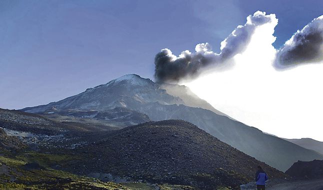
Peru , Ubinas :
Analysis period: January 6-12, 2020 Arequipa, January 13, 2020.
Alert level: ORANGE
The Geophysical Institute of Peru (IGP) reports that the eruptive activity of the Ubinas volcano remains at low levels. To date, the energy of earthquakes associated with the rise of magma to the surface has considerably decreased. There are low and sporadic emissions of bluish gases (of magmatic origin) and water vapor, observed by means of surveillance cameras. According to this scenario, the possibility of volcanic explosions and / or ash emissions is low.
During the period from January 6 to 12, 2020, the IGP recorded and analyzed a total of 70 seismic events associated with the dynamic behavior of the Ubinas volcano, with the predominance of Volcano-Tectonic (VT) type seismic signals related to the fracturing of rocks inside the volcano which, on average, recorded 6 earthquakes per day, all with magnitudes less than M2.9. The seismic signals linked to the rise in magma (hybrid type) have decreased, both in number of events (1 daily earthquake) and in energy.
Visual surveillance, although limited by cloud cover at this time of the year, records very slight emissions of volcanic gases and water vapor which have reached heights of up to 300 m above the summit of the volcano. Monitoring the deformation of the volcanic structure, using GNSS data (processed with fast orbits), does not record any anomalies. MIROVA satellite surveillance also did not record thermal anomalies on the volcano.
Source : Cenvul.
Photo : larepublica.pe
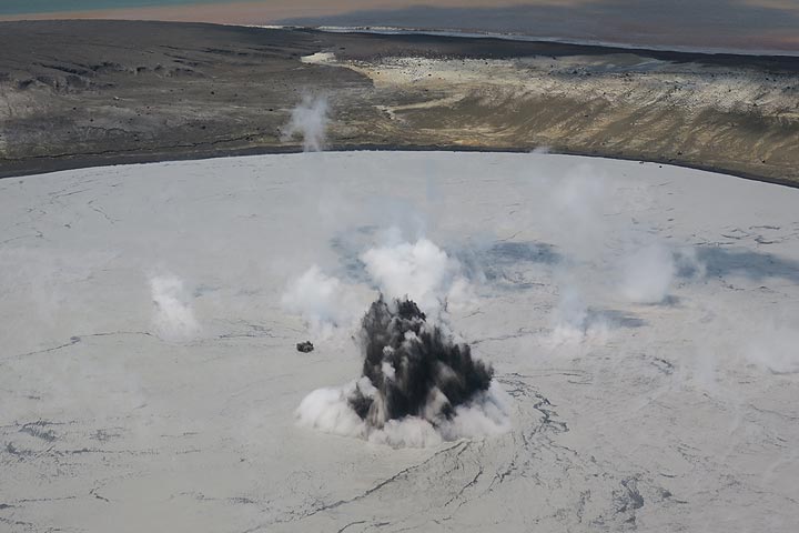
New Zealand , White Island :
Volcanic Alert BulletinWI – 2020/02 , Wed Jan 15 2020 10:15 AM; White Island Volcano
Volcanic Alert Level remains at 2
Aviation Colour Code remains at Yellow
Whakaari/White Island remains in an elevated state of unrest. Very hot gas and steam continues to discharge from vents created by the eruption on December 9th. Further large explosive eruptions are very unlikely on any given day* in the next four weeks. The Volcanic Alert Level remains at Level 2 and the Aviation Colour Code remains Yellow.
Apart from minor ash emissions on December 23rd and 26th, no significantly sustained or strong eruptive activity has been observed since the December 9th eruption. Strong emissions of steam and volcanic gases continue from the vent area created by that eruption. The vent area remains very hot (440°C).
Three short lived episodes of volcanic tremor occurred between 8th and 10th of January accompanied by minor explosions from the active vents. The SO2 gas emission rates are within normal post eruptive ranges. This suggests there is no fresh movement of magma since making it to the surface shortly after the December 2019 eruption.
An explosive eruption from the active vent area remains possible and could occur with no precursory activity. This style of eruption could be driven by the collapse of unstable material around one of the vents, or by a marked decrease in gas emissions allowing water from the reforming crater lake or geothermal system to enter the active hot gas vents. Sudden steam/gas eruptions from other active vents are also possible.
Should any explosive activity produce an ash cloud, the likelihood of ash affecting the mainland remains low.
All our monitoring equipment on the island is operating and the camera feeds have been re-established on the monitoring web pages.
The Volcanic Alert Level remains at Level 2. The Aviation Colour Code remains Yellow.
Volcanic Alert Level 2 indicates moderate to heightened unrest with potential for eruption hazards including unpredictable and life-threatening steam driven eruptions.
The Volcanic Alert Level reflects the current level of volcanic activity and is not a forecast of future activity.
GNS Science and our National Geohazards Monitoring Centre continue to closely monitor Whakaari/White Island for further signs of activity. Further updates will be provided as the situation evolves.
Source : Geonet / Brad Scott , Duty Volcanologist.
Photo : Geonet.
Indonesia , Anak Krakatau :
VOLCANO OBSERVATORY NOTICE FOR AVIATION – VONA.
Issued: January 15 , 2020 .
Volcano: Anak Krakatau (262000)
Current Aviation Colour Code: ORANGE
Previous Aviation Colour Code: orange
Source: Anak Krakatau Volcano Observatory
Notice Number: 2020KRA03
Volcano Location: S 06 deg 06 min 07 sec E 105 deg 25 min 23 sec
Area: Lampung, Indonesia
Summit Elevation: 502 FT (157 M)
Volcanic Activity Summary:
Eruption with volcanic ash cloud at 03h18 UTC (10h18 local).
Volcanic Cloud Height:
Ash-cloud is not visible
Other Volcanic Cloud Information:
visually from cctv crater seen volcanic ash moving to south, volcanic ash black thick 150 meters high from the bottom of the crater.
Remarks:
Eruption recorded on seismogram with maximum amplitude 42 mm and duration 62 second.
Source : Magma Indonésie .
Photo : Andrey Nikiforov / Volcanodiscovey


No comment yet, add your voice below!