
January 09 , 2020 .
Alaska , Shishaldin :
54°45’19 » N 163°58’16 » W,
Summit Elevation 9373 ft (2857 m)
Current Volcano Alert Level: WATCH
Current Aviation Color Code: ORANGE
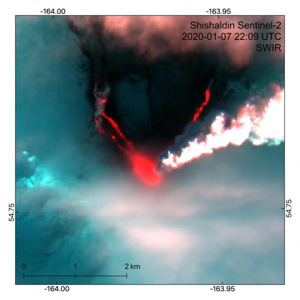
Sentinel-2 image from Jan 7, 2020 at 22:09 UTC. Short-wave infrared false color composite shows active lava flows and a steam-rich plume. Ashfall is visible on snow on the north side of the volcano, while the eastern side is obscured by clouds.
The eruption yesterday morning produced lava flows on the north side of Shishaldin and could be observed in satellite and web camera views throughout the day. This eruption also produced an SO2 plume and an ash cloud until about 12:00 AKST (21:00 UTC) on 2020-01-07 after which the clouds drifted to the northeast and over the Gulf of Alaska for several hours. Ash fallout could be seen on the north side of the volcano in satellite views, but only trace amounts of ash fell on communities to the northeast. Seismicity then decreased significantly and AVO reduced the Aviation Color Code to ORANGE and the Alert Level to WATCH yesterday evening.
Although the present level of seismicity is reduced, it remains possible for unrest to escalate at any time and additional ash producing eruptive events may occur.
Shishaldin is monitored by local seismic and infrasound sensors, satellite data, web cameras, a telemetered geodetic network, and distant infrasound and lightning networks.
Source : AVO.
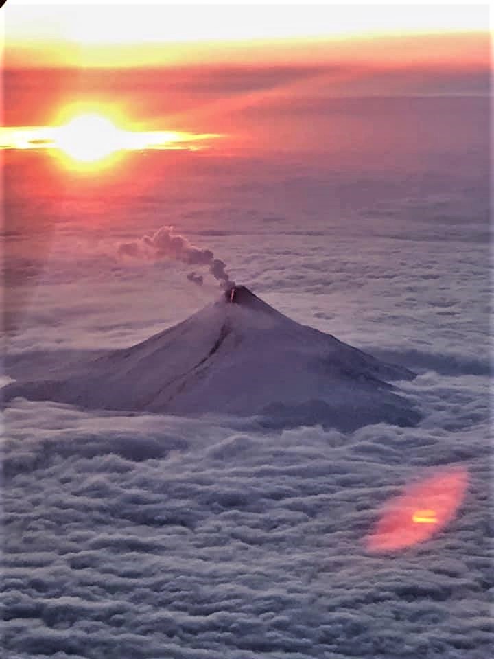
Photo : Dietterich, Hannah. U.S. Coast Guard Air Station Kodiak .
La Réunion , Piton de la Fournaise :
Activity bulletin for Wednesday January 8 at 3:45 p.m. (local time). Alert level: Vigilance.
Since December 31, an increase in seismicity has been recorded at Piton de la Fournaise. Between December 31 and January 8 (3 p.m. local time), 112 earthquakes were recorded under the summit craters (Figures 1 and 2).
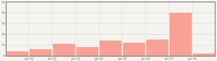
Of the 40 earthquakes of January 7, 22 were recorded during a short seismic crisis between 9:28 p.m. and 9:44 p.m. UT (i.e. 1:28 a.m. and 1:44 a.m. local time on January 8). Since then only 2 earthquakes have been recorded. This decrease is commonly observed following seismic crises, which release for a time the state of constraint of the medium (the constraint being linked to the accumulation of magma in the surface reservoir located about 2 km deep and to its pressurization).
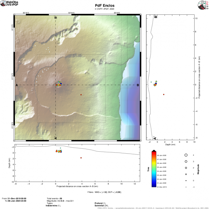
Figure 2: Location map (epicenters) and north-south and east-west sections (showing the location in depth, hypocenters) of earthquakes recorded and located by the OVPF-IPGP between December 31, 2019 and January 8, 2020 (3 p.m. local time) under the Piton de la Fournaise massif. Only localizable earthquakes have been represented on the map. The observatory records seismic events not shown on this map because they cannot be located, due to their too low magnitude (© OVPF-IPGP).
At the same time, inflation (swelling) of the base and top of the Piton de la Fournaise building, which has been observed again since the last week in December, continues (Figure 3).
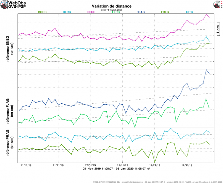
Figure 3: Illustration of the deformation over the last two months. Here are shown the variations in distance between two GPS receivers crossing the Piton de la Fournaise building, at the top (reference SNEG; top), at the base of the terminal cone (reference FJAG; in the middle) and in the far field (reference PRAG; below). An increase is synonymous with elongation and therefore swelling of the volcano; conversely, a decrease is synonymous with contraction and therefore deflation of the volcano (© OVPF-IPGP).
The increase in seismicity, coupled with inflation of the building, is synonymous with the pressurization of a deep source located under the summit craters (Figure 2).
Note that this process of recharging the surface reservoir can last several days to several weeks before the reservoir roof weakens and ruptures, thus giving rise to an injection of magma towards the surface and an eruption, and can also stop without giving rise to an eruption in the short term.
Source : OVPF.
Read the article: http://www.ipgp.fr/fr/ovpf/bulletin-dactivite-mercredi-8-janvier-a-15h45-heure-locale
Colombia , Chiles / Cerro Negro :
Weekly activity bulletin of the Chiles and Cerro Negro volcanoes.
The activity of volcanoes continues at the level: YELLOW LEVEL ■ (III): CHANGES IN THE BEHAVIOR OF VOLCANIC ACTIVITY.
Following the activity of the CHILE VOLCANOES and CERRO NEGRO, the COLOMBIAN GEOLOGICAL SERVICE (SGC) reports that:
For the period from December 31 to January 6, 2020, the occurrence and seismic energy released in the region of the Chiles-Cerro Negro volcanoes continued at low levels, with an increase compared to last week. The earthquakes were entirely related to rock fractures and were located west of the Chiles volcano, at epicentral distances up to 12 km and at depths between 2 and 6 km below the summit of Chiles (4700 m altitude), the maximum local magnitude was M1.9 on the Richter scale.

The other volcanic monitoring parameters did not show significant variations. No manifestation of surface activity was observed.
The COLOMBIAN GEOLOGICAL SERVICE and the GEOPHYSICAL INSTITUTE OF THE NATIONAL POLYTECHNIC SCHOOL OF ECUADOR are attentive to the evolution of the volcanic phenomenon, informing in good time the observed changes. The occurrence of earthquakes with energy levels higher than those reported, which can be felt by the inhabitants of the area of volcanic influence is not excluded.
Source : SGC.
Photo : hablemosdevolcanes.com
Papua -New-Guinea , Ulawun :
5.05°S, 151.33°E
Elevation 2334 m
RVO reported that during 16-22 December 2019 white vapor plumes rose from Ulawun’s Main Crater with some brief periods of no emissions. Occasional emissions rose from the new WSW flank and along the lava flow. A webcam sometimes recoded nighttime incandescence from the area. Seismic activity was low with RSAM values between 100 and 200 units. The Alert Level remained at Stage 1.
The symmetrical basaltic-to-andesitic Ulawun stratovolcano is the highest volcano of the Bismarck arc, and one of Papua New Guinea’s most frequently active. The volcano, also known as the Father, rises above the N coast of the island of New Britain across a low saddle NE of Bamus volcano, the South Son. The upper 1,000 m is unvegetated. A prominent E-W escarpment on the south may be the result of large-scale slumping. Satellitic cones occupy the NW and E flanks. A steep-walled valley cuts the NW side, and a flank lava-flow complex lies to the south of this valley. Historical eruptions date back to the beginning of the 18th century. Twentieth-century eruptions were mildly explosive until 1967, but after 1970 several larger eruptions produced lava flows and basaltic pyroclastic flows, greatly modifying the summit crater.
Source: : Rabaul Volcano Observatory (RVO) , GVP.
Photo : Wikipedia.


No comment yet, add your voice below!