December 22 , 2019. EN . Kamchatka : Sheveluch , Costa Rica : Rincon de la Vieja / Arenal / Poas / Turrialba , Indonesia : Karangetang , Mexico : Popocatepetl .

December 22 , 2019.


Kamchatka , Sheveluch :

VOLCANO OBSERVATORY NOTICE FOR AVIATION (VONA).

Issued: December 22 , 2019.
Volcano: Sheveluch (CAVW #300270)
Current aviation colour code: ORANGE
Previous aviation colour code: orange
Source: KVERT
Notice Number: 2019-183
Volcano Location: N 56 deg 38 min E 161 deg 18 min
Area: Kamchatka, Russia
Summit Elevation: 10768.24 ft (3283 m), the dome elevation ~8200 ft (2500 m)

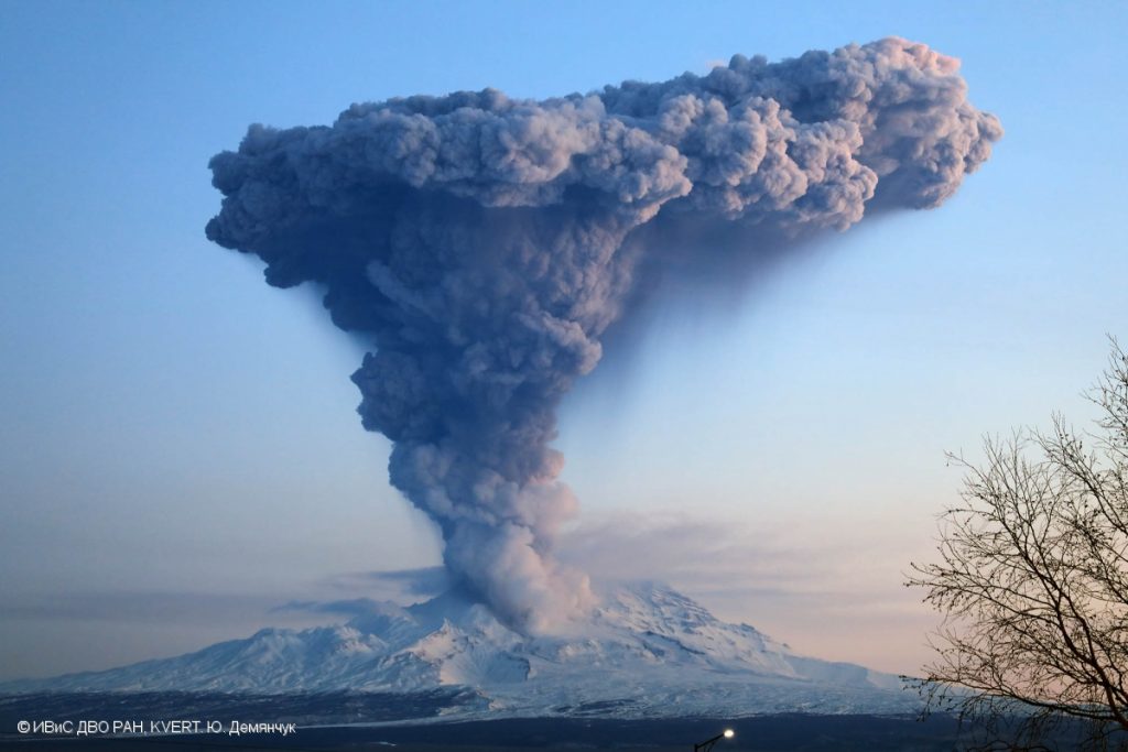
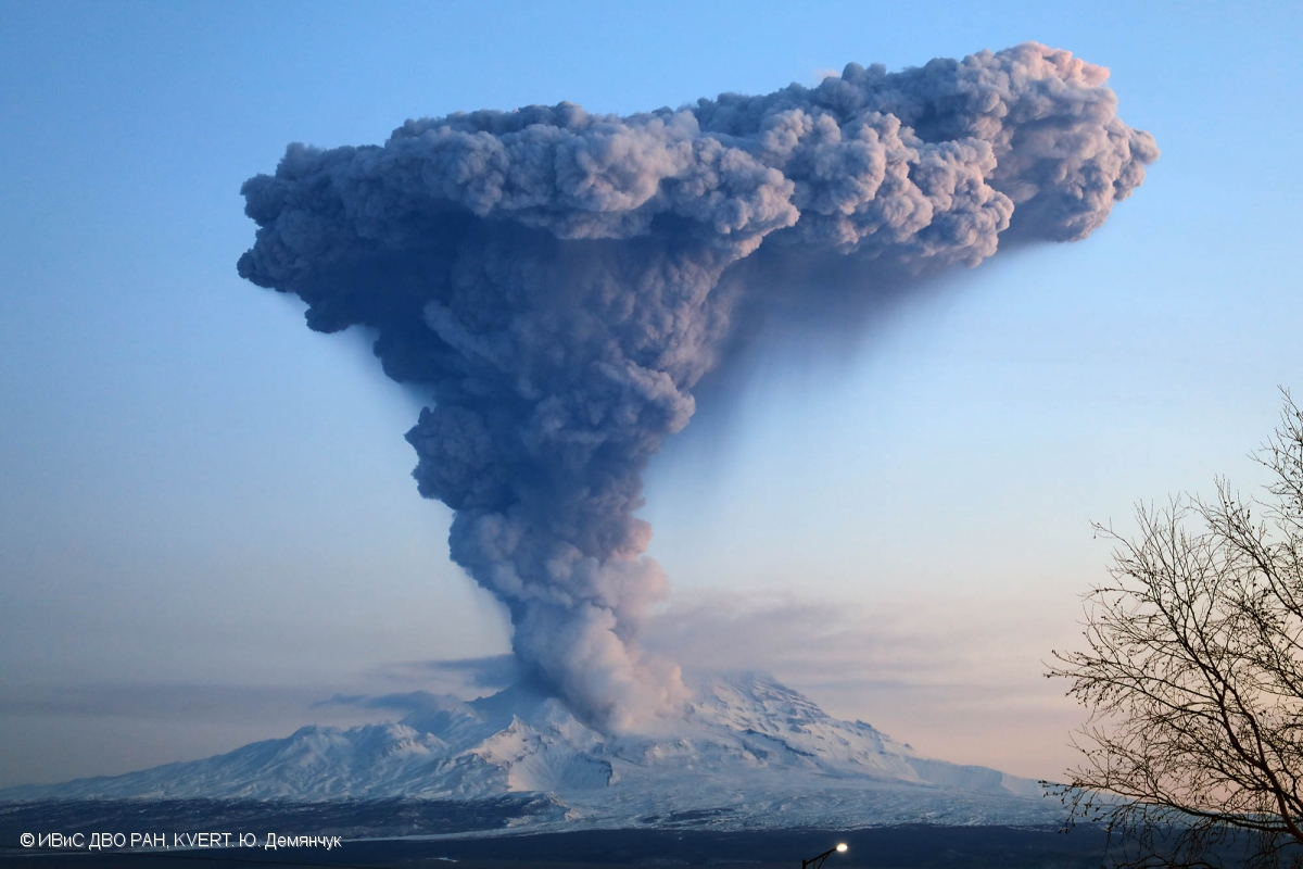
Explosions sent ash up to 10 km a.s.l. on 04 December, 2017, ash plume is extending to the northeast from the volcano.

Volcanic Activity Summary:
An activity of the volcano continues. Explosions sent ash up to 6.0-6.5 km a.s.l. near 23:50 UTC on December 21, according to Tokyo VAAC data. Satellite data by KVERT showed an ash cloud is drifting about 25 km to the east of the volcano.
Explosive-extrusive eruption of the volcano continues. Ash explosions up to 32,800-49,200 ft (10-15 km) a.s.l. could occur at any time. Ongoing activity could affect international and low-flying aircraft.

Volcanic cloud height:
19680-21320 ft (6000-6500 m) AMSL Time and method of ash plume/cloud height determination: 20191222/0030Z – Himawari-8

Other volcanic cloud information:
Distance of ash plume/cloud of the volcano: 16 mi (25 km)
Direction of drift of ash plume/cloud of the volcano: E / azimuth 80 deg
Time and method of ash plume/cloud determination: 20191222/0030Z – Himawari-8

Source : Kvert.

Photo : Yu. Demyanchuk, IVS FEB RAS, KVERT , 4/12/2017 .


Costa Rica , Rincon de la Vieja / Arenal / Poas / Turrialba :

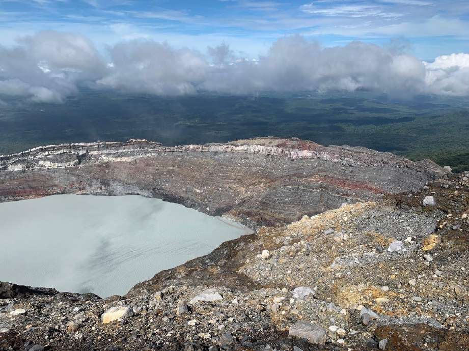
Rincon de la Vieja volcano.

Guanacaste mountain range
10,831 ° N – 85,336 ° W
Altitude of the active crater: 1560 m s.n.m.

The seismic activity was maintained with the appearance of long-type signals (slightly greater than two tens) and a volcanotectonic signal, recorded at the stations closest to the volcano. Sporadic signs of spasmodic and sometimes harmonic tremors are observed.
It is recommended to stay away from the canals of rivers near the volcano in the event of an eruption, due to the possibility of primary lahars., As well as in the event of rain, as secondary lahars could be generated by the ash and materials accumulated in the upper parts of the volcano.

Arenal volcano.

Tilarán mountain range
10412 ° N – 84702 ° W
Altitude of the active crater: 1755 m s.n.m.

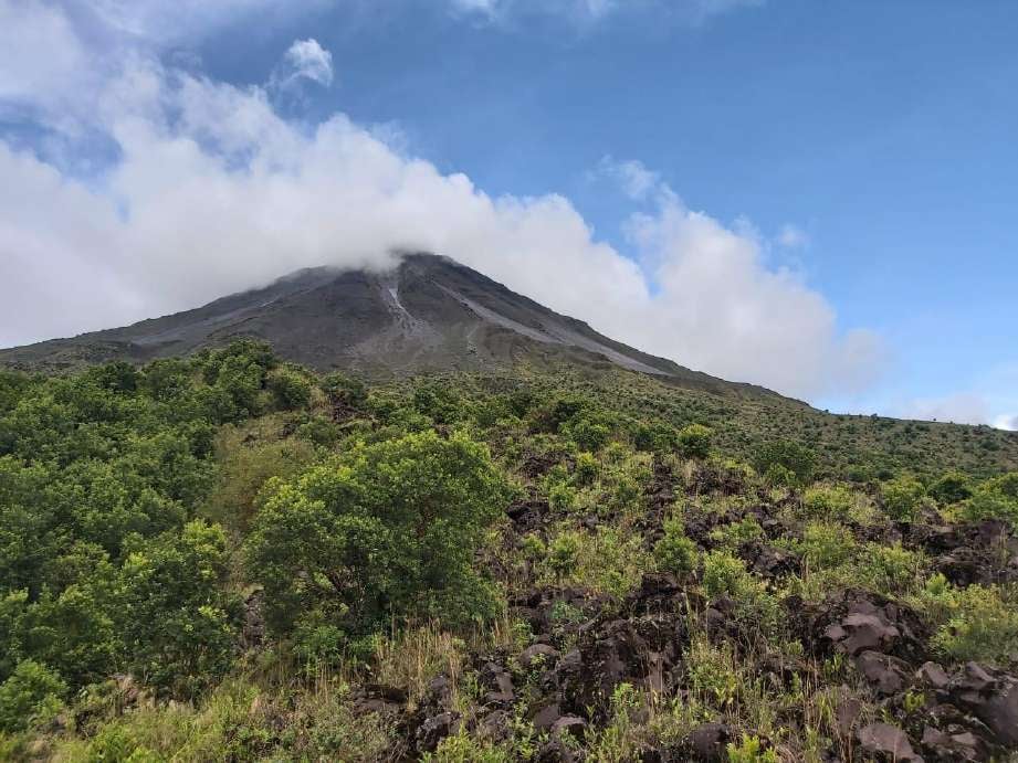
In this photo of the Arenal volcano, we observe the deposits of certain avalanches of debris on the western slope and part of a lava flow covered with vegetation.
Photograph of Minor Taylor from ICE.

The Arenal volcano maintained low seismic activity, characterized by volcano-tectonic events (a dozen), mainly recorded at the nearest station and a hybrid type signal recorded at several stations. No signal associated with an avalanche of debris was recorded.
On a clear day, small fumes of water vapor were observed due to the condensation and the remaining heat which still persists at the top of the main crater.

Poas volcano.

Central volcanic chain
10197 ° N – 84702 ° W
Altitude of the active crater: 2550 m s.n.m.

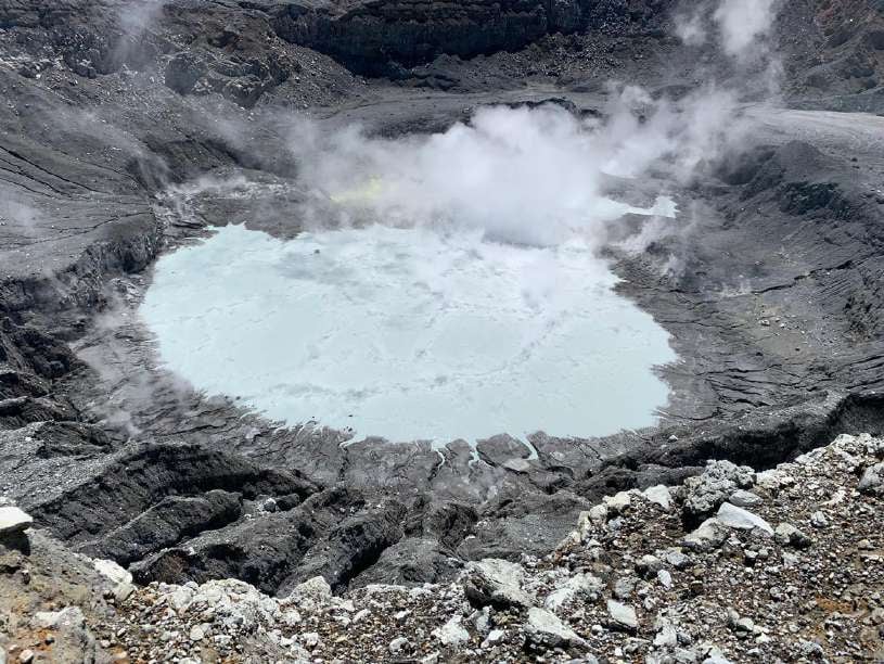
In this photograph of the Poás volcano, we observe the main crater of the Poás volcano seen from the West sector. In the upper central part of the image, the field of fumaroles is visible, which can be recognized by the yellowish color generated by the accumulation of sulfur. This photo was shared by park warden Martín Herrera Núñez.

The lagoon in the crater maintained its level compared to the previous week. The color of the water continues to be greenish. Evaporation processes continue to be intense and precipitation has decreased compared to the previous week. The field of fumaroles rich in sulfur in the Northeast sector maintains its expiration activity. From mouth A, the gas and water vapor outlet was observed almost continuously. Seismically, the low amplitude background tremor (2 to 4.5 Hz) was maintained, as well as the discrete events of LP type (long period) also of low amplitude. Visitors to Poás Volcano National Park are reminded that this site has protocols in case of an eruption. Depending on the type of activity, visits can be suspended or delayed. Tourists are asked to always be alert to any change in activity and to follow the instructions of the park wardens.

It is recommended to stay away from the canals of rivers near the volcano in the event of an eruption, due to the possibility of primary lahars, as well as in the event of rain, since secondary lahars could be generated by ash and materials accumulated in the upper parts of the volcano or by the overflow of the lagoon.

Turrialba volcano.

Central volcanic mountain range
10017 ° N – 83765 ° W
Altitude of the active crater: 3230 m asl

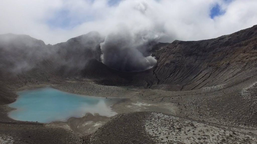
The Turrialba volcano presented a stable and low activity state. The water vapor and gas column dispersed mainly to the West and Southwest sectors. Seismic activity is low, dominated by low frequency discrete earthquakes. The presence of two lakes at the top of the volcano continues, with variations depending on the rain, while a third body of water forms for a few hours after the rains, but then disappears. The glow recorded by volcanic surveillance cameras in the active crater continues as intense as the previous week. No major change in seismicity was reported from the previous week.

This photograph of the Turrialba volcano was taken by members of the national seismological network on February 9, 2018 in the massif. One observes a turquoise green coloration in one of the lagoons. Credits: Dr. Guillaume Alvarado And Blas Sanchez

The public is reminded that the entrance to the Turrialba Volcano National Park, coinciding with a radius of 2 km around the active crater, is closed due to the activity of the volcano. Approaching the crater means very high risk activity.

Source : RSN.

Photos : Juan Carlos López / ICE. Minor Taylor / ICE. Martín Herrera Núñez . Dr. Guillaume Alvarado Et Blas Sanchez.


Indonesia , Karangetang :

Level of activity at level III (SIAGA). G. Karangetang (1,784 m above sea level) entered an eruption period since November 25, 2018. The last eruption occurred on November 29, 2019, resulting in an eruption column height of 100 m. The color of the gray column was observed in gray.

The volcano is clearly visible until it is covered with fog. The smoke from the crater is observed white with a low to moderate intensity about 100 meters above the summit. The weather is cloudy to rainy, light winds from the southeast. The temperature is around 26-29 ° C.
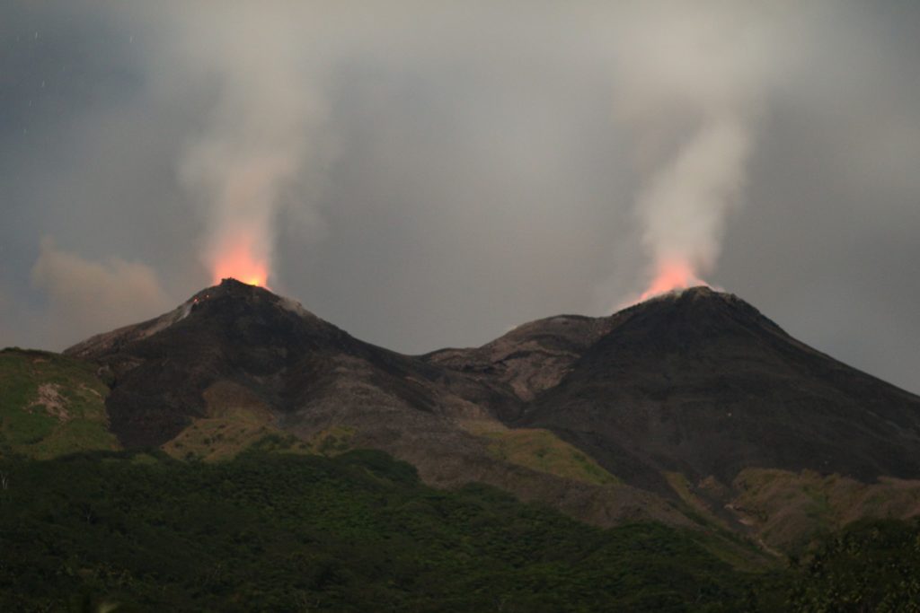
Incandescent projections rising from 10 to 25 m have been observed in the main crater. A lava flow from the main crater to Kali Nanitu, Kali Sense, Kali Pangi was observed with a length of 1000 to 1500 m, sometimes observed in the direction of Kali Beha Barat and Kali Batang over 800 to 1500 m . The smoke from crater 2 was observed to be white and rising from 25 to 50 m. Incandescent projections 10 m high have been observed.

According to the seismographs of December 21, 2019, it was recorded:
67 avalanche earthquake
4 earthquake explosions
4 harmonic earthquakes
2 Hybrid / Multiple Phase earthquakes
2 shallow volcanic earthquakes
9 distant tectonic earthquakes
Continuous tremor, amplitude 0.5-3 mm (dominant value 2 mm).

Recommendation:
The community and visitors / tourists should not approach, climb or move around in the danger forecast area, which is a 2.5 km radius around the summit of Kawah Dua (North crater) and from the main crater (South) and a sectoral expansion zone of the Kawah Dua of 4 km to the North and from the main crater up to 3 km to the West.
It is recommended that the communities around Mount Karangetang prepare masks to cover the nose and mouth, in order to anticipate the potential danger of respiratory problems in the event of ash rain.
The communities living around the rivers that come from the summit of Mount Karangetang must increase their preparation for the potential threat of lahars and flash floods that can descend to the coast.

VONA: The last YELLOW color code was sent on 25 November 2018 at 13:32, linked to the emission of volcanic ash at an altitude of about 2284 m above sea level or about 500 m above the summit, the wind was blowing east.

Source : PVMBG.

Photo : visit siau island , mai 2019.


Mexico , Popocatepetl :

December 21, 11:00 a.m. (December 21, 5:00 p.m. GMT)

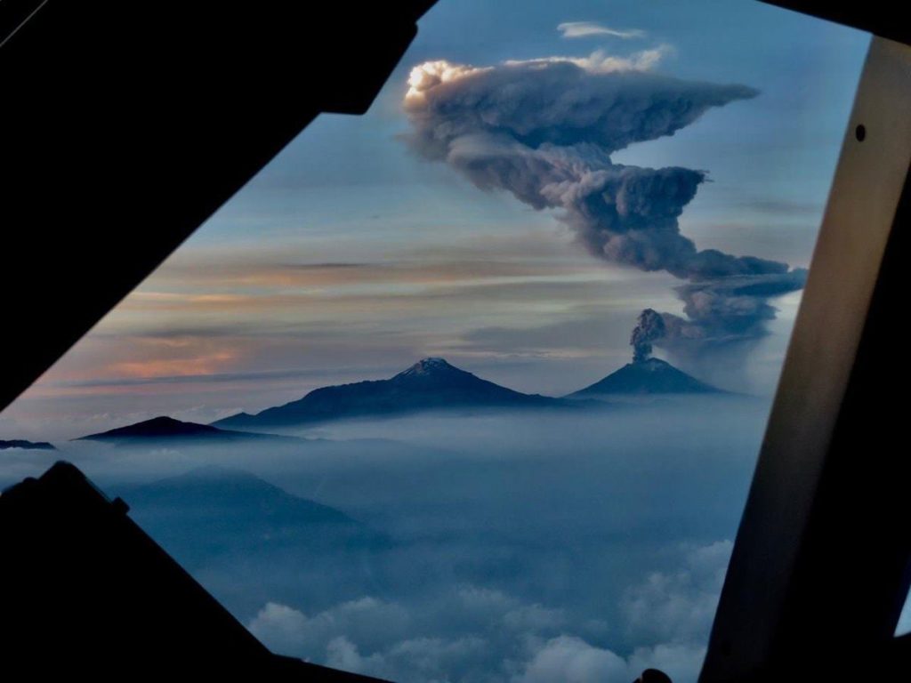
According to the monitoring systems of the Popocatepetl volcano, 162 exhalations have been identified accompanied by water vapor, volcanic gases and a low ash content. In addition, 38 minutes of tremors were recorded, a M 1.4 volcano-tectonic earthquake yesterday at 12:20 p.m. and an explosion at 5:37 a.m. today.

From the early hours of the morning, a constant emission of volcanic gases with sometimes small amounts of ash were observed, which are preferentially dispersed towards the East-North-East due to the strong prevailing winds in the region.

CENAPRED urges NOT to APPROACH the volcano and especially the crater, because of the danger of falling ballistic fragments, and in case of heavy rain, to stay far from the bottom of the ravines because of the danger of mudslides and debris .

The Popocatépetl volcanic traffic light is in YELLOW PHASE 2.

In collaboration with Webcams de México, four high resolution cameras have been installed to monitor the Popocatépetl and Fuego de Colima volcanoes.

In order to improve the visual monitoring of Popocatépetl and Fuego de Colima volcanoes, the National Center for Disaster Prevention (CENAPRED), under the National Coordination for Civil Protection (CNPC) of the Ministry of Security and Citizen Protection (SSPC ), installed, in collaboration with México’s Webcams, four high resolution (HD) cameras to obtain details on the ash emissions and the fragments expelled from these volcanoes as part of their eruptive activity.

Source : Cenapred .

Photo : pilote Jaime del Río , 18/06/2019.
 

22 Décembre 2019. FR . Kamchatka : Sheveluch , Costa Rica : Rincon de la Vieja / Arenal / Poas / Turrialba , Indonésie : Karangetang , Mexique : Popocatepetl .

22 Décembre 2019.


Kamchatka , Sheveluch :

AVIS D’OBSERVATION DU VOLCAN POUR L’AVIATION (VONA).

Émis: 22 Décembre 2019.
Volcan: Sheveluch (CAVW # 300270)
Code couleur actuel de l’aviation: ORANGE
Code couleur de l’aviation précédent: orange
Source: KVERT
Numéro de l’avis: 2019-183
Emplacement du volcan: N 56 deg 38 min E 161 deg 18 min
Région: Kamchatka, Russie
Altitude du sommet: 10768,24 pieds (3283 m), l’élévation du dôme ~ 8200 pieds (2500 m).

Les explosions ont envoyé des cendres jusqu’à 10 km d’altitude le 04 décembre 2017, le panache de cendres s’étend au Nord-Est du volcan.

Résumé de l’activité volcanique:
L’ activité du volcan continue. Des explosions ont envoyé des cendres jusqu’à 6,0-6,5 km d’altitude vers 23h50 UTC le 21 décembre, selon les données du VAAC de Tokyo. Les données satellitaires du KVERT ont montré qu’un nuage de cendres dérive à environ 25 km à l’Est du volcan.
L’éruption explosive-extrusive du volcan continue. Des explosions de cendres jusqu’à 32800-49200 pi (10-15 km) d’altitude pourraient survenir à tout moment. L’activité en cours pourrait affecter les avions internationaux volant à basse altitude.

Hauteur des nuages ​​volcaniques:
19680-21320 ft (6000-6500 m) AMSL Heure et méthode de détermination du panache de cendres / hauteur des nuages: 20191222 / 0030Z – Himawari-8

Autres informations sur les nuages ​​volcaniques:
Distance du panache de cendres / nuage du volcan: 25 km
Direction de la dérive du panache de cendres / nuage du volcan: E / azimut 80 deg
Heure et méthode de détermination du panache de cendres / nuages: 20191222 / 0030Z – Himawari-8

Source : Kvert.

Photo : Yu. Demyanchuk, IVS FEB RAS, KVERT , 4/12/2017 .


Costa Rica , Rincon de la Vieja / Arenal / Poas / Turrialba :

Volcan Rincon de la Vieja .

Chaîne de montagnes de Guanacaste
10 831 ° N – 85 336 ° O
Altitude du cratère actif: 1560 m s.n.m.

L’activité sismique s’est maintenue avec l’apparition de signaux de type longue période (légèrement supérieurs à deux dizaines) et d’un signal volcanotectonique, enregistrés aux stations les plus proches du volcan. Des signes sporadiques de tremors spasmodiques et parfois harmoniques sont observés.
Il est recommandé de rester à l’écart des canaux des rivières à proximité du volcan en cas d’éruption, en raison de la possibilité de lahars primaires., ainsi qu’en cas de pluies, car des lahars secondaires pourraient être générés par les cendres et les matériaux accumulés dans les parties hautes du volcan.

Volcan Arenal .

Chaîne de montagnes de Tilarán
10412 ° N – 84702 ° O
Altitude du cratère actif: 1755 m s.n.m.

Sur cette photo du volcan Arenal,  on observe les dépôts de certaine avalanches de débris sur le versant ouest et une partie d’une coulée de lave couverte de végétation.

Photographie de Minor Taylor d’ICE.

Le volcan Arenal a maintenu une activité sismique faible, caractérisée par des événements de type volcano-tectoniques (une douzaine), principalement enregistrés à la station la plus proche et un signal de type hybride enregistré dans plusieurs stations. Aucun signal associé une avalanche de débris n’a été enregistré.
Par temps clair, de petites émanations de vapeur d’eau ont été observées en raison de la condensation et de la chaleur restante qui persiste toujours au sommet du cratère principal.

Volcan Poas .

Chaîne volcanique centrale 
10197 ° N – 84702 ° O
Altitude du cratère actif: 2550 m s.n.m.

Sur cette photographie du volcan Poás , on observe le cratère principal du volcan Poás vu du secteur Ouest. Dans la partie centrale supérieure de l’image, le champ des fumerolles est visible, ce qui se reconnait à la couleur jaunâtre générée par l’accumulation de soufre. Cette photographie a été partagée par le garde du parc Martín Herrera Núñez.

La lagune dans le cratère a maintenu son niveau par rapport à la semaine précédente. La couleur de l’eau continue d’être verdâtre. Les processus d’évaporation continuent d’être intenses et les précipitations ont diminué par rapport à la semaine précédente. Le champ de fumerolles riche en soufre dans le secteur Nord-Est maintient son activité d’expiration. De la bouche A , il a été observée la sortie de gaz et de vapeur d’eau presque en continu . Sismiquement, le tremor de fond de faible amplitude (2 à 4,5 Hz) s’est maintenu, ainsi que les événements discrets de type LP (longue période) également de faible amplitude. Il est rappelé aux visiteurs du parc national du volcan Poás que ce site dispose de protocoles en cas d’éruption. Selon le type d’activité, les visites peuvent être suspendues ou retardées. Les touristes sont priés de toujours être attentifs à tout changement d’activité et de suivre les instructions des gardes du parc.

Il est recommandé de rester à l’écart des canaux des rivières à proximité du volcan en cas d’éruption, en raison de la possibilité de lahars primaires., ainsi qu’en cas de pluies, car des lahars secondaires pourraient être générés par les cendres et les matériaux accumulés dans les parties hautes du volcan ou par le débordement du lagon.

Volcan Turrialba .

Chaîne de montagnes volcaniques centrales
10017 ° N – 83765 ° O
Altitude du cratère actif: 3230 m s.n.m.

Le volcan Turrialba a présenté un état stable et de faible activité. La colonne de vapeur d’eau et de gaz s’est dispersée principalement vers les secteurs Ouest et  Sud-Ouest. L’activité sismique est faible, dominée par des séismes discrets de basse fréquence. La présence de deux lacs au sommet du volcan continue, avec des variations qui dépendent de la pluie, tandis qu’un troisième plan d’eau se forme pendant quelques heures après les pluies, mais disparaît ensuite. L’incandescence enregistrée par les caméras de surveillance volcanique dans le cratère actif se poursuit aussi intense que la semaine précédente. Aucun changement majeur de sismicité n’a été signalé par rapport à la semaine précédente.

Cette photographie du volcan turrialba a été prise par des membres du réseau sismologique national le 9 février 2018 dans le massif. On observe une coloration verte turquoise dans l’une des lagunes. Crédits : Dr. Guillaume Alvarado Et Blas Sanchez

Il est rappelé au public que l’entrée du parc national du volcan Turrialba, coïncidant avec un rayon de 2 km autour du cratère actif, est fermée en raison de l’activité du volcan. L’approche du cratère signifie une activité à très haut risque.

Source : RSN.

Photos : Juan Carlos López / ICE. Minor Taylor / ICE. Martín Herrera Núñez . Dr. Guillaume Alvarado Et Blas Sanchez.


Indonésie , Karangetang :

Niveau d’activité de niveau III (SIAGA). Le G. Karangetang (1 784 m d’altitude) est rentré dans une période d’éruption depuis le 25 novembre 2018. La dernière éruption s’est produite le 29 novembre 2019, entraînant une hauteur de colonne d’éruption de 100 m. La couleur de la colonne grise était observée en gris.

Le volcan est clairement visible jusqu’à ce qu’il soit recouvert de brouillard. La fumée issue du cratère est observée de couleur blanche avec une intensité faible à modérée à environ 100 mètres au dessus du sommet. Le temps est nuageux à pluvieux, les vents faibles du Sud-Est. La température est d’environ 26-29 ° C.

Des projections incandescentes s’élevant de 10 à 25 m ont été observés dans le cratère principal. Une coulée de lave depuis le cratère principal vers la Kali Nanitu, la Kali Sense, la Kali Pangi a été observée avec une longueur de 1000 à 1500 m, parfois observée en direction de la Kali Beha Barat et la Kali Batang sur 800 à 1500 m.  La fumée issue du cratère 2 a été observée comme étant blanche et s’élevant de 25 à 50 m. Des projections incandescentes de 10 m de haut ont été observés.

Selon les sismographes du 21 décembre 2019 , il a été enregistré:
67 tremblement de terre d’avalanches
4 tremblement de terre d’explosions
4 tremblements de terre harmoniques
2 tremblements de terre Hybride / Phase Multiples
2  tremblements de terre volcanique peu profond
9 tremblements de terre tectoniques lointains
Tremor continu, amplitude 0,5-3 mm (valeur dominante 2 mm).

Recommandation:
La communauté et les visiteurs / touristes ne doivent pas s’approcher, ne pas grimper et ne pas se déplacer dans la zone de prévision de danger, qui est un rayon de 2,5 km autour du sommet du Kawah Dua (cratère Nord) et du cratère principal (Sud) et une zone d’expansion sectorielle du Kawah Dua  de 4 km au Nord et du cratère principal jusqu’à 3 km à l’Ouest.
Il est recommandé aux communautés autour du mont Karangetang de préparer des masques pour couvrir le nez et la bouche, afin d’anticiper le danger potentiel de problèmes respiratoires en cas de pluie de cendres.
Les communautés vivant autour des rivières qui proviennent du sommet du mont Karangetang doivent augmenter leur préparation face à la menace potentielle de lahars et d’inondations soudaines qui peuvent descendre jusqu’à la côte.

VONA: Le dernier code couleur JAUNE a été envoyé  le 25 novembre 2018 à 13:32  , lié aux émissions de cendres volcaniques à une altitude d’environ 2284 m au-dessus du niveau de la mer ou à environ 500 m au-dessus du sommet, le vent soufflait vers l’est.

Source : PVMBG.

Photo : visit siau island , mai 2019.


Mexique , Popocatepetl :

21 décembre, 11h00 (21 décembre, 17h00 GMT)

Selon les systèmes de surveillance du volcan Popocatepetl, 162 exhalations ont été identifiées accompagnées de vapeur d’eau, de gaz volcaniques et d’une faible teneur en cendres. De plus, 38 minutes de tremors ont été enregistrées, un tremblement de terre volcano-tectonique de M 1,4, hier à 12 h 20, et une explosion à 5 h 37 aujourd’hui .

Dès les premières heures du matin, une émission constante de gaz volcaniques avec parfois de faibles quantités de cendres ont été observées, qui sont dispersées préférentiellement vers l’Est-Nord-Est en raison des forts vents dominants dans la région .

Le CENAPRED demande instamment de NE PAS APPROCHER le volcan et surtout le cratère, en raison du danger de chute de fragments balistiques, et en cas de fortes pluies , de rester  loin du fond des ravins en raison du danger de coulées de boue et de débris.

Le feu de signalisation volcanique du Popocatépetl est en JAUNE PHASE 2.

En collaboration avec Webcams de México, quatre caméras haute résolution ont été installées pour surveiller les volcans Popocatépetl et Fuego de Colima.

Afin d’améliorer le suivi visuel des volcans Popocatépetl et Fuego de Colima, le Centre National de Prévention des Catastrophes (CENAPRED), sous la Coordination Nationale de la Protection Civile (CNPC) du Ministère de la Sécurité et de la Protection des Citoyens (SSPC) ,  a installé, en collaboration avec Webcams de México, quatre caméras haute résolution (HD) pour obtenir des détails sur les émissions de cendres et les fragments expulsés de ces volcans dans le cadre de leur activité éruptive.

Source : Cenapred .

Photo : pilote Jaime del Río , 18/06/2019.