
December 14 , 2019.
Japan , Asosan :
Smoke rises from Mount Aso, an active volcano, near the city of Aso in Kumamoto prefecture on December 13, 2019. Mount Aso’s huge caldera dominates the southwestern main island of Kyushu, where the 1,592-metre volcano is a popular tourist spot.
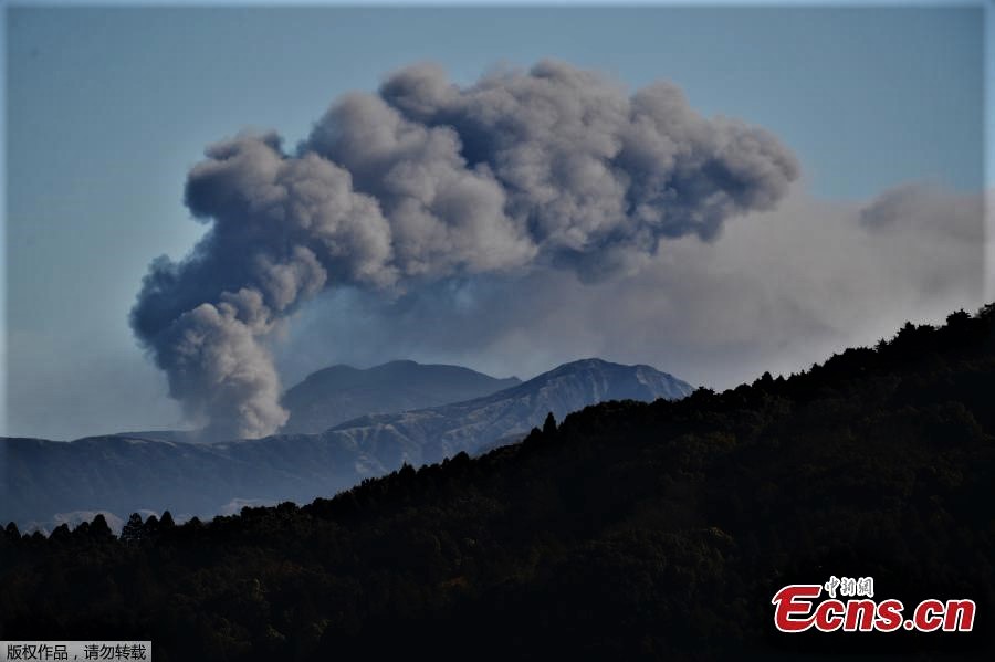
The 24-km-wide Asosan caldera was formed during four major explosive eruptions from 300,000 to 90,000 years ago. These produced voluminous pyroclastic flows that covered much of Kyushu. The last of these, the Aso-4 eruption, produced more than 600 km3 of airfall tephra and pyroclastic-flow deposits. A group of 17 central cones was constructed in the middle of the caldera, one of which, Nakadake, is one of Japan’s most active volcanoes. It was the location of Japan’s first documented historical eruption in 553 CE. The Nakadake complex has remained active throughout the Holocene. Several other cones have been active during the Holocene, including the Kometsuka scoria cone as recently as about 210 CE. Historical eruptions have largely consisted of basaltic to basaltic-andesite ash emission with periodic strombolian and phreatomagmatic activity. The summit crater of Nakadake is accessible by toll road and cable car, and is one of Kyushu’s most popular tourist destinations.
Sources : ECNS , GVP.
Photo : Japan Agencies .
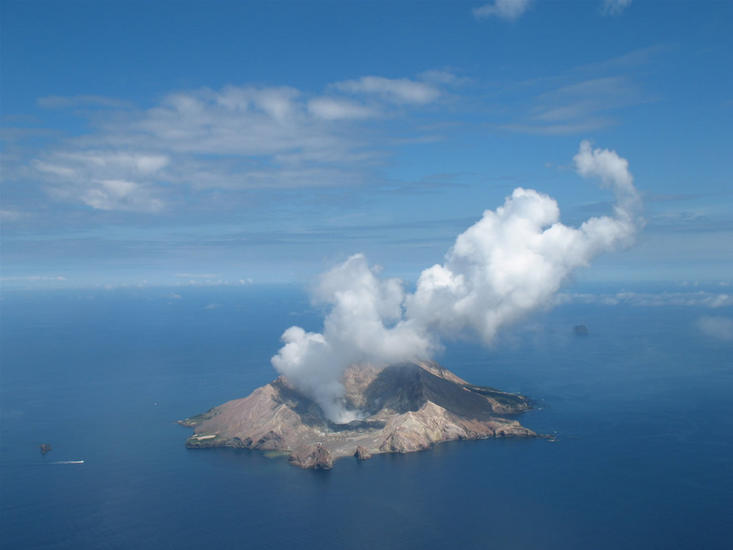
New Zealand , White Island :
Whakaari/White Island likelihood of future eruption: Update #3
Published: Fri Dec 13 2019 1:00 PM
Expert judgement this morning is that there is still a 50-60% chance (medium likelihood) of an eruption occurring that could impact outside of the vent area within the next 24 hours. This is the same level of risk as yesterday.
Future scenario
At 10:30am 13 December, GNS Science volcanologists reviewed all available data and updated the likelihood of an eruption that would impact beyond the vent area (marked in the image below) occurring within the next 24 hours.
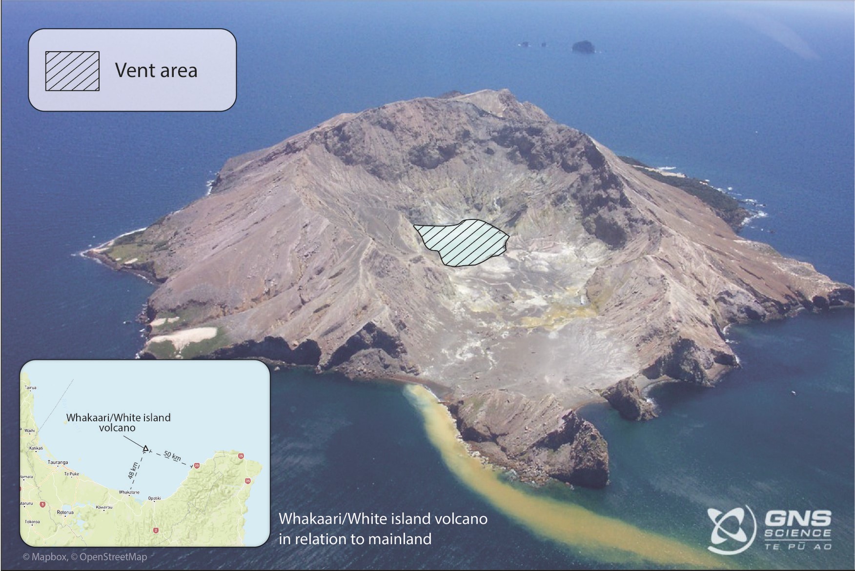
Photo of Whakaari/White Island from 2004, showing the marked vent area. The distance between the edge of the crater lake and the ocean at the bottom of the image is about 700m.
Their new calculation was that there is still a 50-60% chance (medium likelihood) of an eruption occurring that could impact outside of the marked vent area within the next 24 hours.
How does this compare to previous estimates?
Since early 2013, eruption likelihoods for Whakaari have been calculated via expert judgement as part of internal staff health and safety procedures. Our expert scientists calculate the risk for all volcanoes at Volcanic Alert Level 1 or higher.
The table below shows the expert judgement of eruption likelihoods for time periods corresponding to when the Volcanic Alert Level (VAL) was at 1 (29 October 2019), and at VAL 2 one week prior to Monday’s eruption (2 December 2019). This is in comparison to the expert judgements conducted on 11, 12 and 13 December 2019, after the eruption. There have been other expert judgements not listed here, including one carried out on 18 November 2019 when the VAL was raised to Level 2. The last expert judgement before the eruption was on 2nd December.
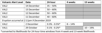
Likelihood of eruption over time by expert judgement – 13 December 2019
For 29 October and 2 December, eruption likelihoods were calculated for 4-week and 13-week time windows respectively and have been converted in this table to reflect relevant 24-hour time windows for comparison.
The time periods used for the expert judgements vary depending on the level of activity at the volcano – when activity increases, we do expert judgements more often and for a shorter time window to reflect the changing situation.
Since the eruption on 9 December, eruption likelihoods have been calculated for a 24-hour time period. The table shows that the likelihood of an eruption is now about 100 times higher than in early December.
The Volcanic Alert Level is not linked directly to risk and likelihoods but describes the level of current volcanic activity.
Timeline of activity
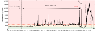
Volcanic tremor and alert levels at Whakaari/White Island since 13 November 2019
Here is an annotated graph showing volcanic tremor over the last month recorded at one of our monitoring stations on the island. The 9 December eruption is shown in the red box. Also shown are the Volcanic Alert Levels for each time period. Volcanic tremor is a useful proxy for activity on a volcano, but is only one of the monitoring data streams used by volcanologists to make their expert judgements.
Volcanic Alert BulletinWI – 2019/22 , Sat Dec 14 2019 11:30 AM; White Island Volcano
Volcanic Alert Level remains at 2
Aviation Colour Code remains at Orange
The level of volcanic tremor has declined significantly overnight at Whakaari/White Island. No further eruptions have occurred since Monday 9 December. The Volcanic Alert Level remains at Level 2.
Since the eruption on Monday, there has been no further significant eruptive activity. Yesterday evening the volcanic tremor level dropped significantly. A very short lived and un-sustained period of ash emission has been observed, however ashfall didn’t extend beyond the active vent area.
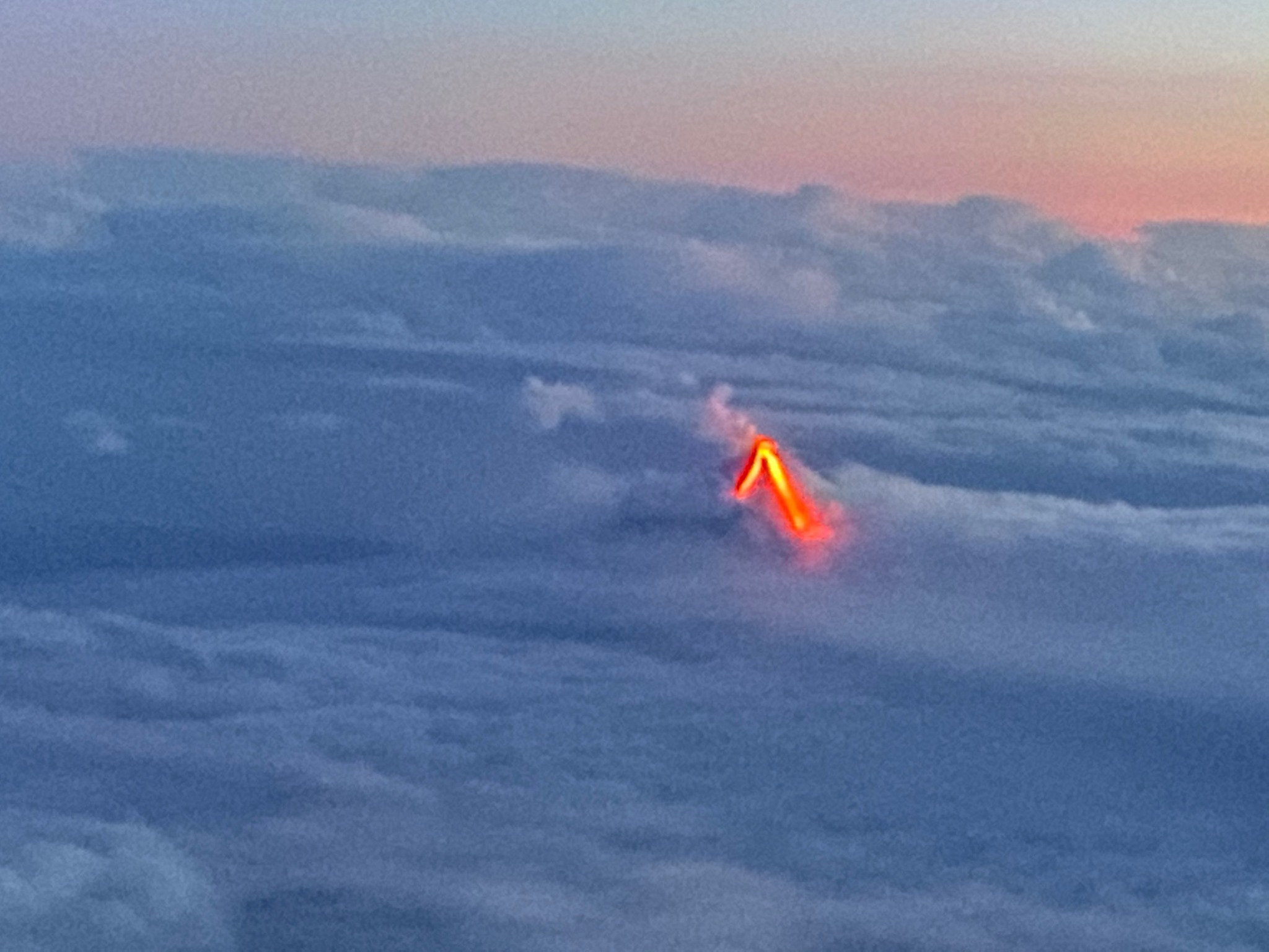
We conducted an overflight Friday (13 December) afternoon, confirming small scale gas jetting and steam burst are occurring in the active vents. The hazy and fumy conditions restricted the temperature measurements of the vent area. Overnight web camera images recorded a glow from the vent area, confirming high heat flow.
The combined interpretation of all our data is still that magma is degassing at shallow depths and the situation remains highly volatile. We are updating the eruption probability table, and this will be published on the GeoNet website later this morning.
Some monitoring equipment is partially buried under ash and may stop functioning over the weekend as batteries run out. However, we are still receiving data from the remaining equipment which allows us to monitor the volcano.
Should moderate-large explosive ash eruptions occur, there is an extremely low likelihood of any potential ash fall affecting on land areas. The steam and gas plume may also reach onshore and people may smell gas, depending on the prevailing wind direction.
We will provide daily updates on activity unless the situation changes.
Source : Attributable to: Natalia Deligne, GNS Science Volcanic Hazard and Risk Modeller . Brad Scott / Duty Volcanologist , Geonet .
Lire l’article 1 : https://www.geonet.org.nz/news/17xy4eSxRx515P8X3DY4O4
Lire le communiqué : https://www.geonet.org.nz/vabs/4WxUDZ669ZSKhH5au8JcBV
Photo : Geonet gallery
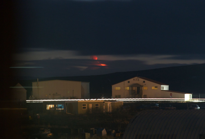
Alaska , Shishaldin :
54°45’19 » N 163°58’16 » W,
Summit Elevation 9373 ft (2857 m)
Current Volcano Alert Level: WATCH
Current Aviation Color Code: ORANGE
The eruption of Shishaldin volcano that began in late July continues. Eruption activity at the volcano intensified yesterday with the possible collapse of the summit spatter cone and lava flows on the north and northwest flanks. This event produced a small ash cloud to 25,000 feet above sea level that drifted to the northwest and dissipated within a couple of hours. Highly elevated surface temperatures were observed in satellite data from today. Web camera images show a robust steam plume form the summit and incandescence in night-time images. Seismicity at the volcano remains elevated.
Thus far, the 2019 eruption has produced lava flows, pyroclastic flows, and lahars (mudflows) on the flanks of the volcano. For most of the current eruption, ash emissions have been restricted to the immediate vicinity of the volcano and altitudes of less than 12,000 ft. asl. During this heightened level of activity more powerful explosions such as the one that occurred yesterday could occur with little warning and produce higher ash clouds that may pose a hazard to aircraft.
Shishaldin is monitored by local seismic and infrasound sensors, satellite data, web cameras, a telemetered geodetic and tilt network, and distant infrasound and lightning networks.
Source : AVO.
Photo : Kellie Coonc Aylward via Sherine France. Aaron Merculief.
Indonesia , Merapi :
MONT MERAPI ACTIVITY REPORT, December 6 to 12, 2019
OBSERVATION RESULTS
Visual.
The weather around Mount Merapi is generally sunny in the morning, while the evening is mainly foggy. There is white smoke, medium to thick with low pressure. A maximum smoke height of 100 m was observed from the Mount Merapi observation post in Jrakah on December 12, 2019 at 5:55 a.m.
Morphological analysis of the crater area based on photos of the Southeast sector did not show any significant morphological changes. The volume of the lava dome based on the analysis of aerial photos obtained with a drone on November 19, 2019 is estimated at 396,000 m3.
Seismicity.
This week, the seismicity of Mount Merapi recorded:
16 deep volcanic earthquakes (VTA),
9 multiple phase earthquakes (MP),
6 avalanche earthquakes (RF),
14 low frequency earthquakes (LF)
19 tectonic earthquakes (TT).
The intensity of the VTA earthquakes this week is higher than last week.
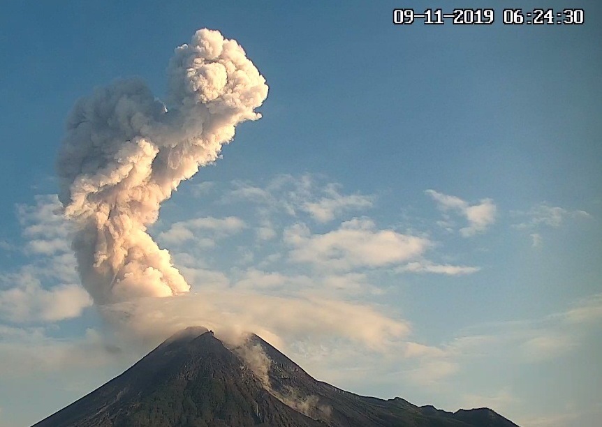
The Merapi in activity on November 09, 2019.
Deformation.
The deformation of the Merapi which was monitored by EDM and GPS this week did not show any significant change.
Rain and lahars.
This week, there was rain at the Mount Merapi observation post with the highest precipitation of 48 mm / hour for 20 minutes at Pos Kaliurang on December 7, 2019. There were no lahars or runoff additional in the rivers that descend from Mount Merapi.
Conclusion:
Based on the results of the visual and instrumental observations, it was concluded that:
1. The lava dome is currently in a stable state
2. The volcanic activity of Mount Merapi is still quite high and is determined by the level of activity « WASPADA ».
3. The current potential danger is in the form of hot clouds from the collapse of the lava dome and explosions of volcanic material from explosive eruptions.
Source : BPPTKG.
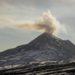
Kamchatka , Bezymianny :
VOLCANO OBSERVATORY NOTICE FOR AVIATION (VONA).
Issued: December 13 , 2019
Volcano: Bezymianny (CAVW #300250)
Current aviation colour code: ORANGE
Previous aviation colour code: yellow
Source: KVERT
Notice Number: 2019-179
Volcano Location: N 55 deg 58 min E 160 deg 35 min
Area: Kamchatka, Russia
Summit Elevation: 9452.96 ft (2882 m)
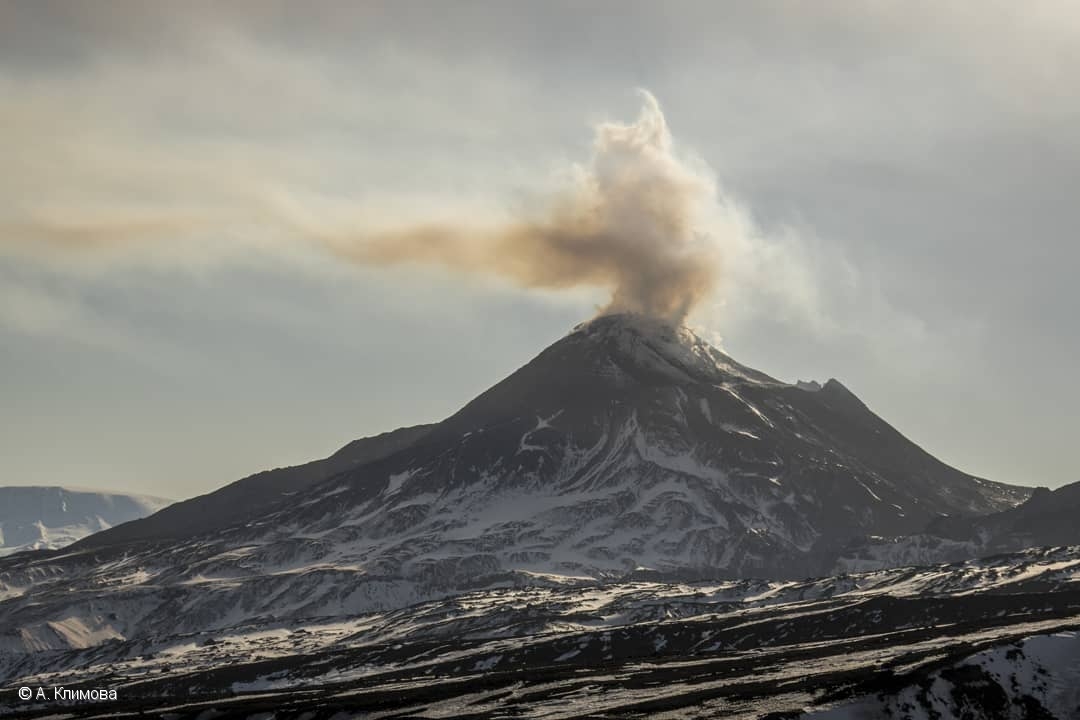
Fumarole activity of Bezymianny volcano on April 14, 2019.
Volcanic Activity Summary:
Activity of the volcano began to increasing from beginning of December. The incandescence of the volcano summit in the dark time, a lava flow and sometimes a strong fumarolic activity were obserwing during the last weeks. The temperature of thermal anomaly gradually increases. Strong ash explosions up to 10-15 km a.s.l. could occur at any time during next week. KVERT continues to monitor Bezymianny volcano.
Activity of the volcano gradually increases. Ongoing activity could affect international and low-flying aircraft.
Volcanic cloud height:
NO ASH CLOUD PRODUSED
Other volcanic cloud information:
NO ASH CLOUD PRODUSED
Source : Kvert .
Photo : A. Klimova , 14/4/2019 .


No comment yet, add your voice below!