
December 05 , 2019.
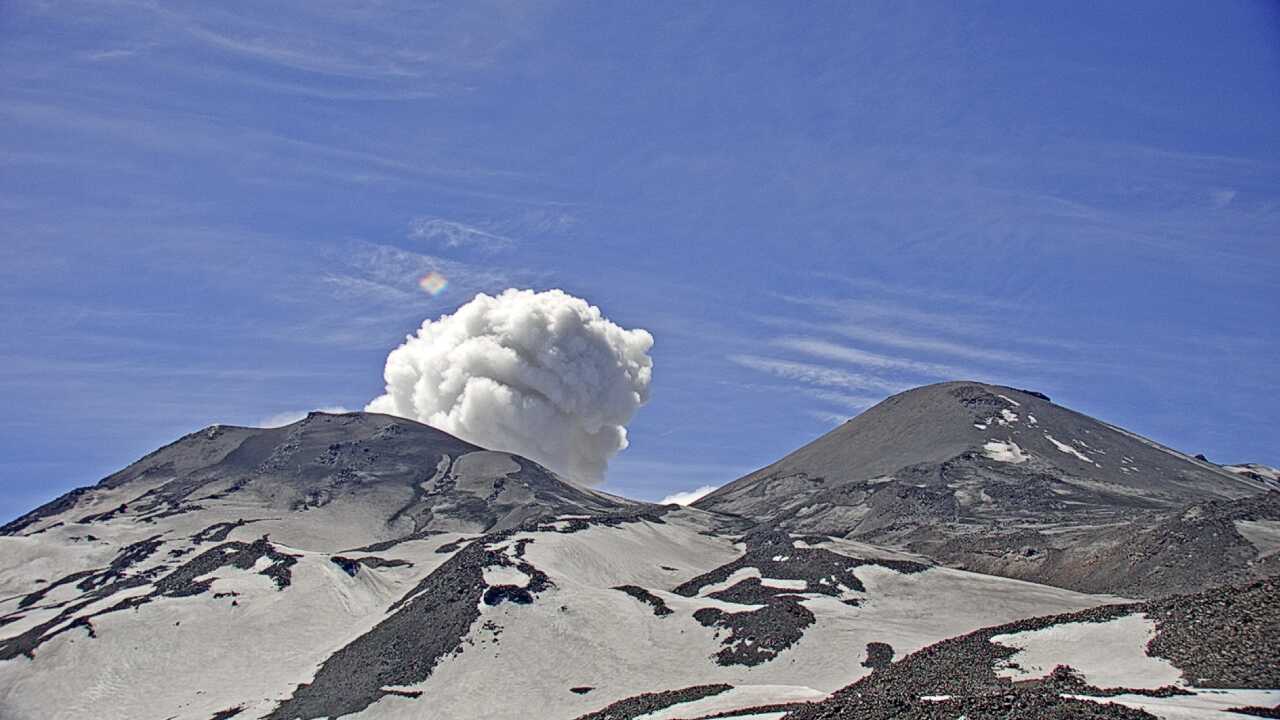
Alaska , Shishaldin :
54.756°N, 163.97°W
Elevation 2857 m
AVO reported that seismic levels at Shishaldin were variable but elevated during 26 November-3 December. Weather clouds sometimes obscured satellite image views and mostly prevented webcam views, though elevated surface temperatures were still visible in multiple satellite images. An active 1.5-km-long lava flow on the NW flank was visible in satellite images on 1 December. Continuous tremor transitioned to episodic bursts during the morning of 2 December, but by 3 December a decrease in seismic activity and surface temperatures suggested another pause in lava effusion. The Aviation Color Code remained at Orange and the Volcano Alert Level remained at Watch.
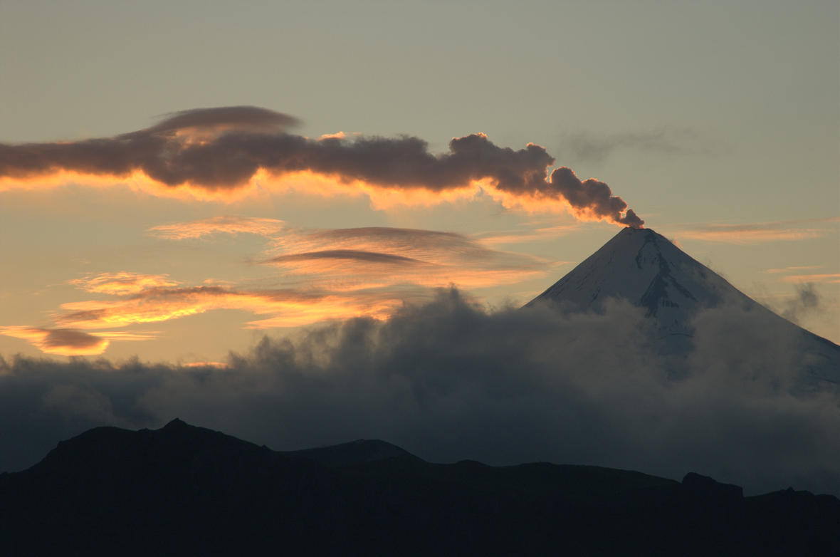
Satellite images recorded elevated surface temperatures yesterday afternoon and overnight consistent with lava effusion, which was verified by a pilot report in the evening of visible lava on the volcano flank. No ash was reported by either observation. Seismicity also increased during the day suggesting renewed effusive eruption from a pause the night before.
Shishaldin is monitored by local seismic and infrasound sensors, satellite data, web cameras, a telemetered geodetic network, and distant infrasound and lightning networks.
Source: US Geological Survey , Alaska Volcano Observatory (AVO) , GVP .
Photo : Cyrus Read .
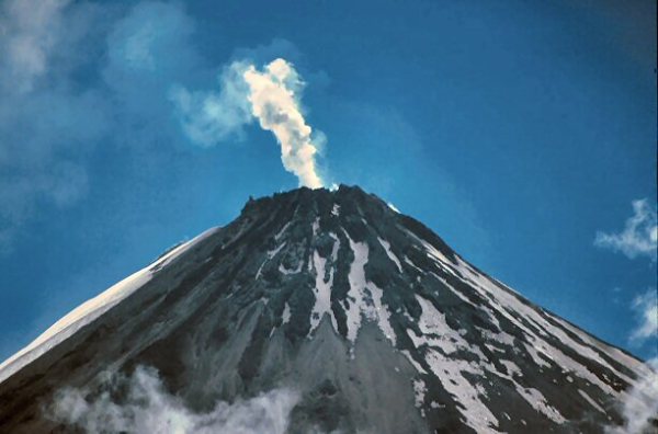
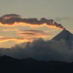
Ecuador , Sangay :
Update of the eruptive activity.
abstract
The Sangay Volcano continues in its current eruptive phase that began on May 7, 2019 (a total of 211 days until the release of this report). With seismic and acoustic monitoring, it is evident that the internal activity is dominated by signals of fluid movements and explosions. A small deformation of the volcano has been observed during the last month, probably due to the arrival of new deep magmas. On the surface, a semi-continuous activity was maintained from two eruptive centers: the central crater and the Ñuñurco vent (South-East). The central crater has explosive activity that generates small clouds of gas and ash. During the last month, emissions reached 2 km above the crater and are often dispersed to the northeast with high variability, causing small ash falls in the provinces of Chimborazo, Morona Santiago and Azuay.
On the other hand, the Ñuñurco vent has an effusive activity that results in an almost continuous emission of lava flows that are deposited along the southeast flank of the Sangay. On the bends of the lava flows, small rock falls (pyroclastic flows) reach the basin and the upper channel of the Volcan River. These deposits cause small temporary dams in the Volcán River, which are remobilized by precipitation, forming mudslides and debris (lahars). The accumulation of volcanic sediments in this river that flows downstream from the Upano River has been persistent in recent months (see Special Report No. 5). Recently, Lahares deposits have reached the confluence with the Upano River, partially filling it.
Based on the monitoring parameters, it is evident that the eruptive process continues without a clear tendency to increase or decrease. Therefore, it is estimated that the most likely short-term scenario is that the activity will continue with the same phenomena as those observed up to the date of publication of this report. However, the possibility of a sudden variation in the activity of the volcano is not excluded. The Institute of Geophysics of the National Polytechnic School remains attentive to the ongoing eruptive process on the Sangay volcano and will inform the moment of any variation in its behavior.
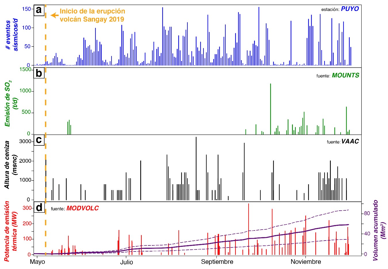
Multiparameter graph of Sangay volcano activity from May to 1 December 2019. a: seismic activity (number of events per day) detected at PUYO station (source: IG-EPN); b: SO2 emissions (tonnes per day) detected by the Sentinel-5P satellite sensor (source: MOUNTS); c: height of ash clouds (m above crater level) detected by the GOES-16 satellite sensor (source: Washington VAAC); d: thermal emission power (megawatt) detected by the MODIS satellite sensor (source: MODVOLC) and estimated accumulated lava volume (million m3, the dotted lines represent the error range).
Event Ñuñurco: lava flows and collapses
During the last flight of the Sangay on 3 December, it was confirmed that the Ñuñurco vent continued to emit lava flows with maximum apparent temperatures between 100 and 210 ° C. To date, an estimated 58 ± 29 million m3 of lava has been emitted for thermal alert analysis. As in recent months, small collapses of the margins of the fronts of these flows have been observed, producing small pyroclastic flows that reach the base of the cone, which accumulate in the upper Volcán River.
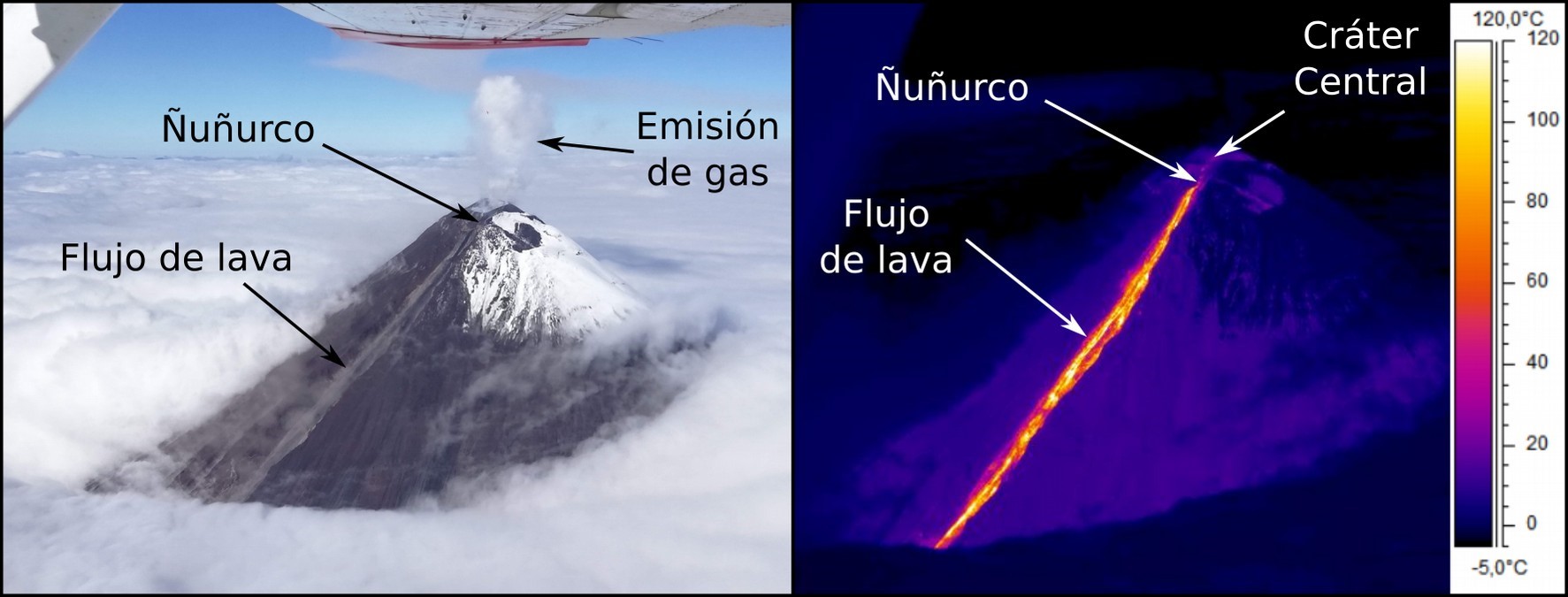
View of the southeast sector of the Sangay volcano: left, visual and right image, infrared image (photography: C. Viracucha and thermal analysis: F. Naranjo, IG-EPN, 03-12-2019).
Source : IGEPN
Read the full article : https://www.igepn.edu.ec/servicios/noticias/1770-informe-especial-del-volcan-sangay-n-6-2019?fbclid=IwAR3XjJM-M0zQ8Ud1NE7D-4p6iMcDnH2UQDd7wa7DbFizfdaT8wjJgA01HEA
Photo : blocs.xtec.cat.
Chile , Nevados of Chillan :
Report of Special Volcanic Activity (REAV), Nevados de Chillán Volcanic Complex Region, December 4, 2019 at 02:35 local time (mainland Chile).
The National Geological and Mining Service of Chile (Sernageomin) discloses the following PRELIMINARY information obtained from the monitoring equipment of the National Volcanic Monitoring Network (NVRN) processed and analyzed at the Volcanological Observatory of the South Andes (OVDAS) ):
On Wednesday 04 December at 02h 02 and 02h18 local time (05:02 and 05h18 UTC), the monitoring stations installed near the Nevados de Chillán volcanic complex recorded two explosions associated with LP type seismic signals.
The characteristics of LP earthquakes are as follows:
TIME OF ORIGIN: 02h 02 local time (05 h 02 UTC)
LATITUDE: 36 868 ° S
LONGITUDE: 71,367 ° W
DEPTH: 2,0 km
REDUCED DISPLACEMENT : 579 cm2
ACOUSTIC SIGNAL: 1.6 Pascals (Pa) reduced to 1 km
TIME OF ORIGIN: 02h18 local time (05h18 UTC)
REDUCED DISPLACEMENT: 562 cm2
ACOUSTIC SIGNAL: 0.9 Pascals (Pa) reduced to 1 km
OBSERVATIONS:
The gas column associated with the explosion was approximately 200 m high, above the crater.
The volcanic technical alert is maintained at the ORANGE level.
Sernageomin monitors online and informs in a timely manner of possible changes in volcanic activity.
Source et photo : Sernageomin .
Indonesia , Dukono :
VOLCANO OBSERVATORY NOTICE FOR AVIATION – VONA.
Issued: December 04 , 2019
Volcano: Dukono (268010)
Current Aviation Colour Code: ORANGE
Previous Aviation Colour Code: orange
Source: Dukono Volcano Observatory
Notice Number: 2019DUK104
Volcano Location: N 01 deg 41 min 35 sec E 127 deg 53 min 38 sec
Area: North Maluku, Indonesia
Summit Elevation: 3933 FT (1229 M)
Volcanic Activity Summary:
Eruption with volcanic ash cloud at 21h54 UTC (06h54 local).
Volcanic Cloud Height:
Best estimate of ash-cloud top is around 4893 FT (1529 M) above sea level, may be higher than what can be observed clearly. Source of height data: ground observer.
Other Volcanic Cloud Information:
Ash-cloud moving to south
Remarks:
Eruption and ash emission is continuing.
Level II activity (WASPADA). G. Dukono (1229 m altitude) is experiencing a continuous eruption. The last eruption occurred on November 24, 2019, resulting in a 500 m eruption column height. The color of the column was observed from white to gray.
The volcano is clearly visible until it is covered with fog. The smoke from the crater is observed white / gray with a high intensity and thick at about 300-800 meters above the summit. Weak to the south. The temperature is about 26 to 30 ° C., the humidity is 75 to 83%.
The seismographs of December 4, 2019 recorded:
4 earthquakes of emission / eruption
A deep volcanic earthquake
Continuous tremor, amplitude 0.5-8 mm (dominant value 2 mm)
Recommendation:
(1) The community around G. Dukono and visitors / tourists should not climb or approach the crater of Malupang Warirang within a radius of 2 km.
(2) As eruptions of volcanic ash occur periodically and the distribution of ash follows the direction and speed of the wind, it is recommended that the community around G. Dukono equip himself with masks to be used in case of need to avoid the threat of volcanic ash in the respiratory system.
Source : Magma Indonésie , PVMBG.
Vidéo : Claudio Jung via Facebook


No comment yet, add your voice below!