
November 23 , 2019 .
El Salvador , San Miguel ( Chaparrastique) :
Special file n ° 3: the seismicity of the San Miguel volcano tends to decrease.
During the past week, the seismicity of the San Miguel volcano has tended to decrease. There is a reduction in the number of earthquakes and the frequency content. The seismicity of the volcano is still very frequent and has a certain degree of impulsivity, due to the presence of small fractures and cracks in the volcano duct.
The activity of the volcano tends to normalize and for the moment, it is not considered a danger for the population, without losing sight of the sudden changes in the equilibrium conditions of the system. These variations are continuously monitored and if certain conditions indicate increased activity, which may present a potential danger to the population, the national civil protection system will make an announcement later.
Figure 1 shows the seismicity recorded in the VSM station for the last 7 days.

Figure 1 Seismicity of the volcano recorded from November 15 to 22, 2019. Associated with the opening of cracks and the movements of magmatic gases.
Figure 2 shows the recording of the number of earthquakes per hour and their respective frequency (IF) in the last 14 days. There is a clear decrease in the number of earthquakes recorded from 16, mainly at high frequency.

Figure 2. The dotted line indicates the downward trend in the number of earthquakes. The black line divides the frequency index (IF). Black dots above zero represent earthquakes at high frequency and below zero, weak earthquakes. Associated with the opening of cracks in the ducts because of the pressure due to fluid movements in the internal volcanic system.
The images captured by the volcanic surveillance camera located on the Pacayal volcano do not show the presence of gas or vapor from the crater and no abnormal situation report was provided by the local observers network.
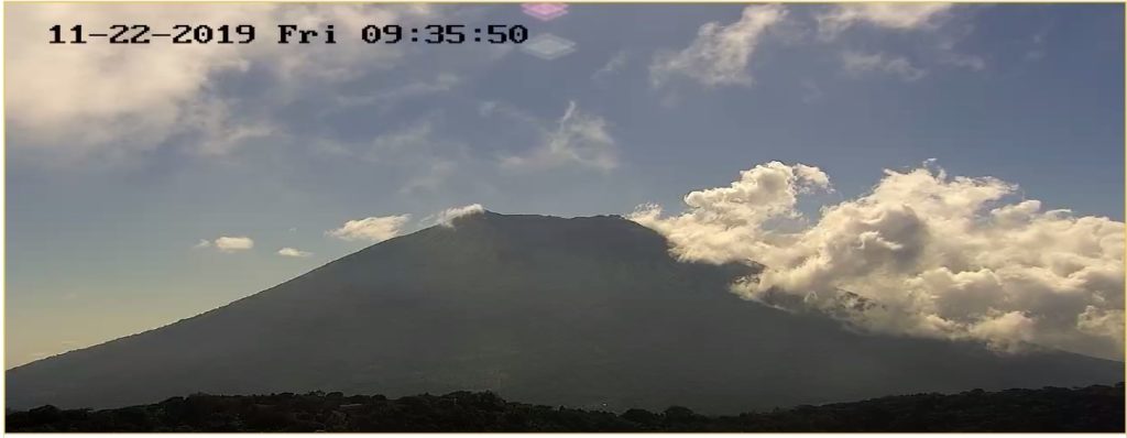
Figure 3. Captured image at 09:35 on Friday, November 22, 2019, there is no gas or vapor from the crater of the volcano.
Figure 4 shows the flow of gas emitted by the volcano from September 2018 to date.
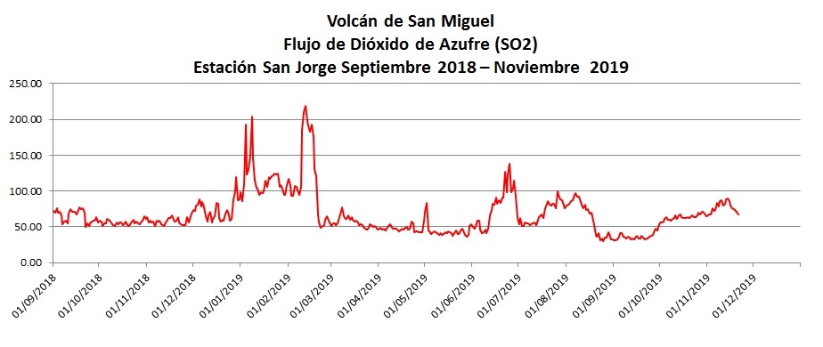
Figure 4. The flow of sulfur dioxide emitted by the crater of the volcano remains low and is considered normal for the volcanic system of San Miguel (flow <400 tons / day).
Interpretation:
At present, the current activity of the volcano is dominated by the presence and prevalence of high-frequency earthquakes, highlighting the presence of cracks and ducts associated with changes in fluid pressure and magma in the shallow part of the ducts of the volcanic system.
The next update of this report will be on Friday, November 29, 2019. In the event of a material change, an advance special report will be published.
Source : Marn .
Alaska , Shishaldin :
54°45’19 » N 163°58’16 » W,
Summit Elevation 9373 ft (2857 m)
Current Volcano Alert Level: WATCH
Current Aviation Color Code: ORANGE
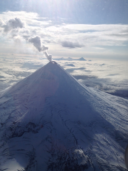
The episodic eruption of Shishaldin Volcano continues, with low-level activity confined to the flanks of the cone. Seismicity was variable during the week, with weak seismicity recorded last weekend likely corresponding to very minor eruptive activity or a pause in the eruption. Seismicity increased during the middle part of the week, accompanied by the advancement of lava flows and the generation of volcanic debris flows (lahars) from melting of the surrounding snow and ice, as observed in satellite imagery. Satellite imagery also showed new, minor ash deposits on the flanks of the volcano probably related to low-level summit explosions and local collapses of unstable deposits of accumulated lava. Seismicity subsequently dropped again late in the week and remains at a relatively low level, suggesting another transition to only very weak eruptive activity or a pause in the eruption.
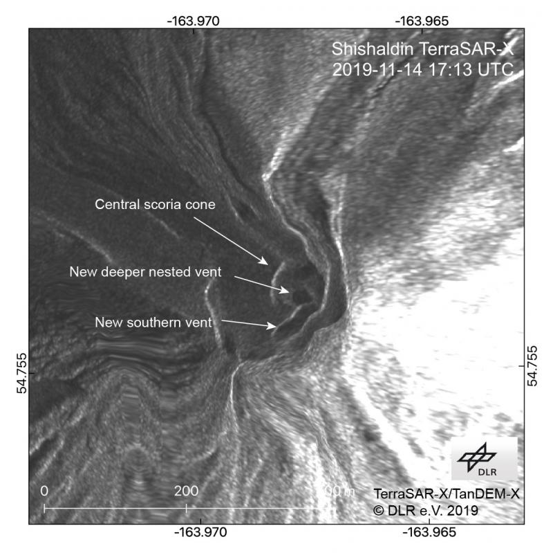
This high-resolution satellite radar image of the summit of Shishaldin shows the growing central scoria cone filling most of the pre-eruptive summit crater. A new vent within this cone and another to the south have formed during recent more explosive activity. Lava flows and lahars are also visible radiating from the summit to the northwest, north, and northeast. Some distortion is caused by the oblique satellite look angle and the terrain correction. This imagery was provided by Simon Plank (German Aerospace Center, DLR) through an ongoing collaboration with the Alaska Volcano Observatory on remote sensing of volcanic eruptions.
Shishaldin is monitored by local seismic and infrasound sensors, satellite data, web cameras, a telemetered geodetic and tilt network, and distant infrasound and lightning networks.
Shishaldin volcano, located near the center of Unimak Island in the eastern Aleutian Islands, is a spectacular symmetric cone with a base diameter of approximately 16 km (10 mi). A 200-m-wide (660 ft) funnel-shaped summit crater typically emits a steam plume and occasional small amounts of ash. Shishaldin is one of the most active volcanoes in the Aleutian volcanic arc, with at least 54 episodes of unrest including over 24 confirmed eruptions since 1775. Most eruptions are relatively small, although the April-May 1999 event generated an ash column that reached 45,000 ft above sea level.
Source : AVO.
Photos : Dietterich, Hannah , Joseph Korpiewski, U.S. Coast Guard.
Costa Rica , Rincon de la Vieja / Arenal / Poas / Irazú / Turrialba :
Rincon de la Vieja Volcano:
Volcanic chain of Guanacaste.
10,831 ° N – 85,336 ° W
Altitude of the active crater: 1560 m.s..m.
The seismic activity has slightly increased with respect to the appearance of long-period type signals compared to last week (just under three tens) and volcano-tectonic type signals, the two types of signals recorded at nearest resorts to the volcano. Spasmodic tremor decreased in amplitude from October 31 and continues to this day.
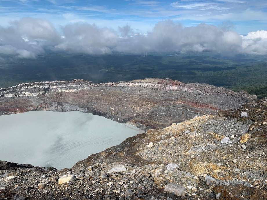
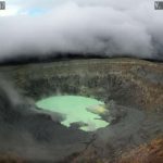
On this photo of the Rincon de la Vieja volcano of November 19, 2019, taken from the southern flank of the crater, a greenish gray tone is observed in the acidic lake. Floating sulfur spherules are also observed as a result of the chemical reaction between the gases and the lake. Photograph of Juan Carlos López of ICE.
It is recommended to stay away from the canals of rivers near the volcano in case of eruption, due to the possibility of presence of primary lahars. In addition, rains, ashes and accumulated material in the upper parts of the volcano could generate secondary lahars.
Arenal Volcano:
Volcanic chain of Tilarán
10,412 ° N – 84,702 ° W
Altitude of the active crater: 1755 m.s..m.
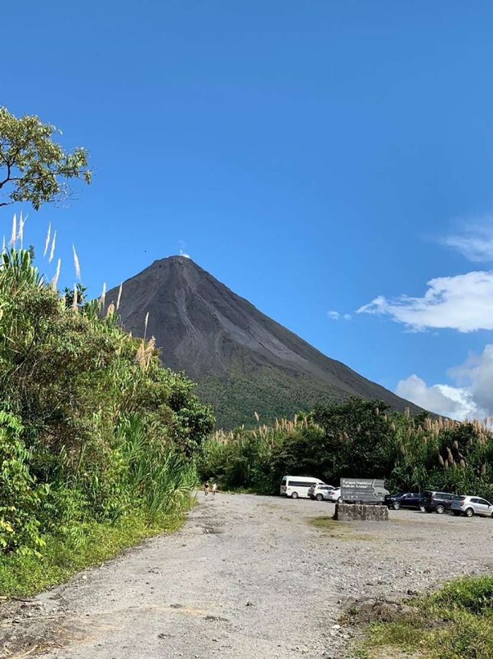
On this photo of Arenal volcano, at least 4 debris flows and a small emanation of water vapor are observed from the west flank of the volcano. Photograph by Henriette Bakkar of ICE.
The Arenal volcano has maintained a seismic activity characterized by volcano-tectonic events (less than a dozen), mainly recorded at the nearest station of the volcano. On November 17 at 16:48, a signal associated with the descent of a debris flow is recorded at the seismological stations. On a clear day, small fumes of water vapor were observed as a result of condensation and the remaining heat that persists at the top of the main crater.
Poas Volcano:
Central volcanic chain
10.197 ° N – 84.702 ° W
Altitude of the active crater: 2550 m.s..m.
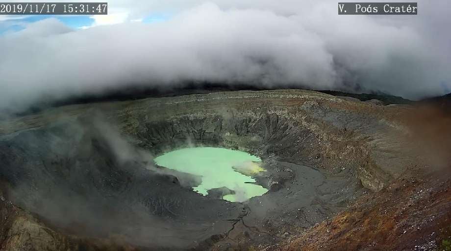
In this photo of the Poás volcano, the lake has been maintained compared to the previous week, with water covering the area of Boca A, Boca B and almost reaching the fumaroles sector. Image captured with the volcanic surveillance camera of the RSN
The lake maintained its surface area compared to the previous week. The color of the water tends to be greenish. The evaporation processes were light and the precipitation constant. The field of fumaroles rich in sulfur in the North-East sector maintains its activity of expiration. Seismically, the background tremor of low amplitude (2 to 4.5 Hz) was maintained, as well as discrete events of type LP (long period) and low amplitude. Visitors to the Poás Volcano National Park are reminded that this site has protocols for eruptions. Depending on the type of activity, visits may be suspended or delayed. In the main crater view, there are four shelters to protect against eruptions. Tourists are advised to always pay attention to any change of activity and to follow the instructions of the park wardens. It is recommended to stay away from the canals of the rivers near the volcano in case of rain, as the secondary lahars could be generated.
Irazú Volcano:
Central volcanic chain
9,982 ° N – 83,850 ° W
Altitude of the active crater: 3330 m.s..m.
No significant volcanic processes have been reported during this week. During a field visit on November 3, it was observed that the level of crater lake had decreased significantly compared to previous months. The decrease in the water level at the end of the rainy season could be attributed mainly to the processes of water infiltration due to fractures, because the processes of evaporation are not intense in this lake, as they are in the Poás volcano. In addition, the sliding of the inner wall of the crater is still active and deposits materials inside the lagoon. The bubble exit through the crater lagoon water continues slightly. The sulfur smell of fumaroles located in the northwest sector of the crater is also continuing. Visitors are reminded to respect the authorized boundaries, to take pictures in the National Park and to comply with the provisions of the park wardens.
Turrialba Volcano:
Central volcanic chain
10,017 ° N – 83,765 ° W
Altitude of the active crater: 3230 m.s..m.
The Turrialba volcano showed a stable and weak state of activity. The column of water vapor and gas dispersed mainly to the western and southwestern sectors. The seismic activity is little dominated by discrete low frequency earthquakes. The presence of two lakes at the top of the volcano continues, with variations depending on the rain, while a third body of water forms a few hours after the rains, then disappears. The incandescence recorded by the volcanic surveillance cameras in the active crater continues as intense as the previous week. No major changes in seismicity were reported compared to the previous week.
Source : RSN.
Photos : Juan Carlos López / ICE , Henriette Bakkar / ICE , RSN , Dr. Paulo Ruiz , Javier Elizondo .


No comment yet, add your voice below!