
November 17 , 2019 .
Costa Rica , Rincon de la Vieja / Poas / Irazu / Turrialba :
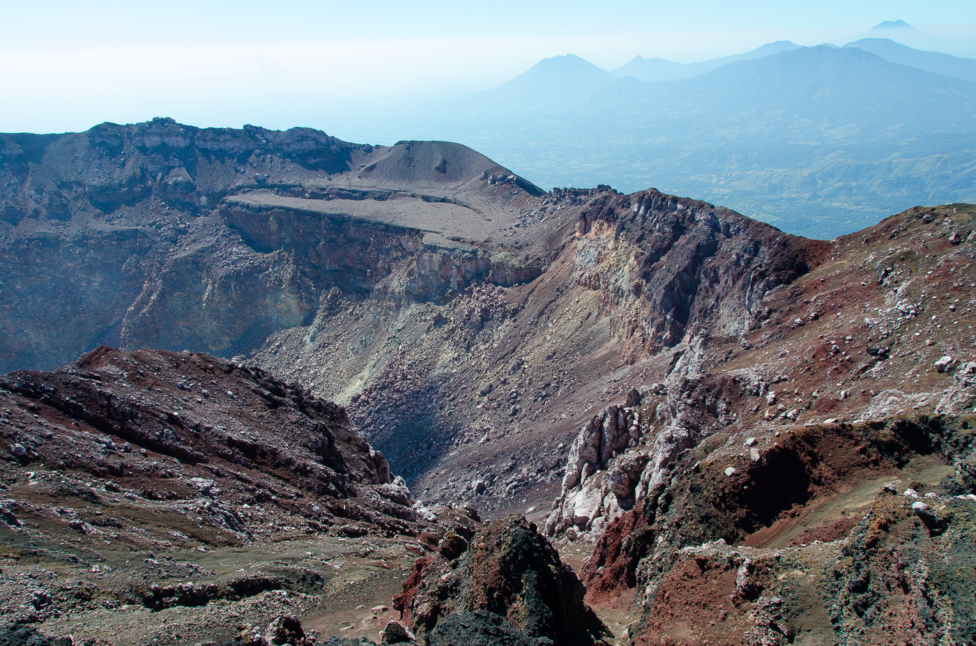
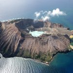
Rincon de la Vieja Volcano .
Volcanic chain of Guanacaste.
10,831 ° N – 85,336 ° W
Altitude of the active crater: 1560 m.s..m.
The seismic activity has decreased in terms of appearance of long-period type signals (just under two tens), recorded at the nearest station of the volcano. Spasmodic tremor decreased in amplitude from October 31 and continues to this day.
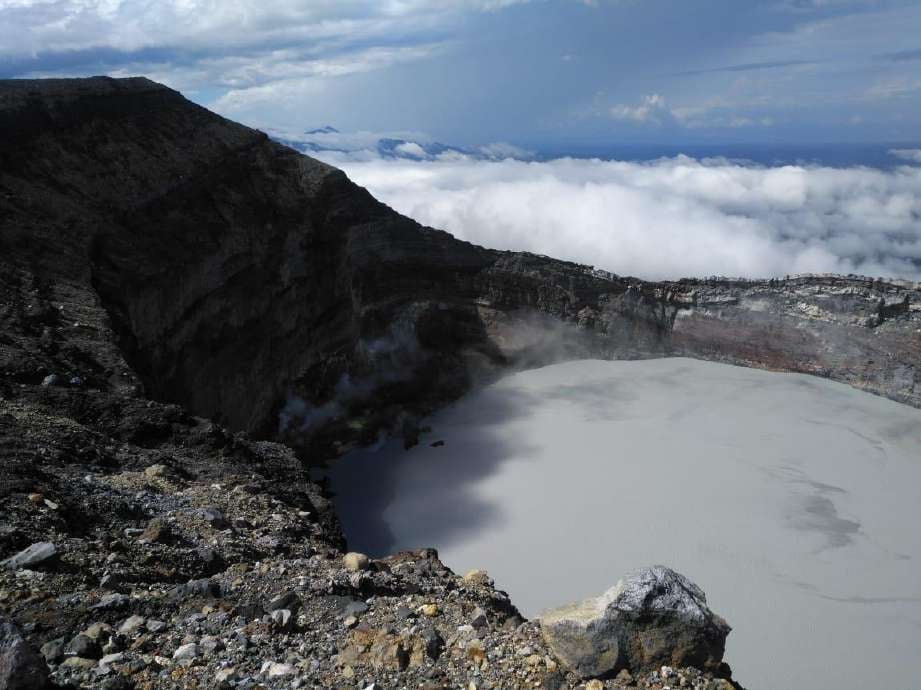
On this photo of the Rincon de la Vieja volcano, dated October 31, 2019, taken from the southern flank of the crater, a greyish tone is observed in the acidic lake as well as fumaroles in activity of the West sector. Floating sulfur spherules are also observed as a result of the chemical reaction between the gases and the lake. Photography. Waldo Taylor of ICE.
It is recommended to stay away from the canals of rivers near the volcano in case of eruption, due to the possibility of presence of primary lahars. In addition to the rains, ashes and accumulated material in the upper parts of the volcano could generate secondary lahars.
Poas Volcano.
Central volcanic chain
10.197 ° N – 84.702 ° W
Altitude of the active crater: 2550 m.s..m.
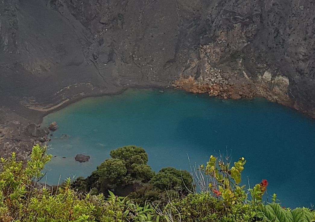
The lake maintained its surface area compared to the previous week. The color of the water tends to be greenish. The evaporation processes were less intense and the precipitation constant. The field of fumaroles rich in sulfur in the North-East sector maintains its activity of expiration. Seismically, the bottom tremor of low amplitude (2 to 4.5 Hz) was maintained, as well as discrete events of type LP (long period) and low amplitude.

In this photo of the Poás volcano, we can see the lake which has been maintained compared to the previous week, with water covering the area of Boca A, Boca B and almost reaching the area fumaroles.
Visitors to the Poás Volcano National Park are reminded that this site has protocols for eruptions. Depending on the type of activity, visits may be suspended or delayed. In the main crater view, there are four shelters to protect against eruptions. Tourists are advised to always pay attention to any change of activity and to follow the instructions of the park wardens. It is recommended to stay away from the canals of the rivers near the volcano in case of rain, because the secondary lahars could be generated by ashes and material accumulated in the high parts of the volcano by eruptions of years and weeks preceding.
Irazú Volcano.
Central volcanic chain
9,982 ° N – 83,850 ° W
Altitude of the active crater: 3330 m.s..m.
No significant volcanic processes have been reported during this week. During a field visit on November 3, it was observed that the level of crater lake had decreased significantly compared to previous months. The decrease in the water level at the end of the rainy season could be attributed mainly to the processes of water infiltration due to fractures, because the processes of evaporation are not intense in this lake, as they are in the Poás volcano. In addition, the sliding of the inner wall of the crater is still active and deposits materials inside the lagoon. The bubble exit through the crater lagoon water continues slightly. The sulfur smell of fumaroles located in the northwest sector of the crater is also continuing. Visitors are reminded to respect the authorized boundaries, to take pictures in the National Park and to comply with the arrangements of the park wardens.
Turrialba Volcano.
Central volcanic chain
10,017 ° N – 83,765 ° W
Altitude of the active crater: 3230 m.s..m.
The observation of the volcano by the cameras has been difficult because of the strong cloudiness that prevails in the region, when the sky is released momentarily a degassing activity is observed. There is no report of falling ash or sulfur smell.
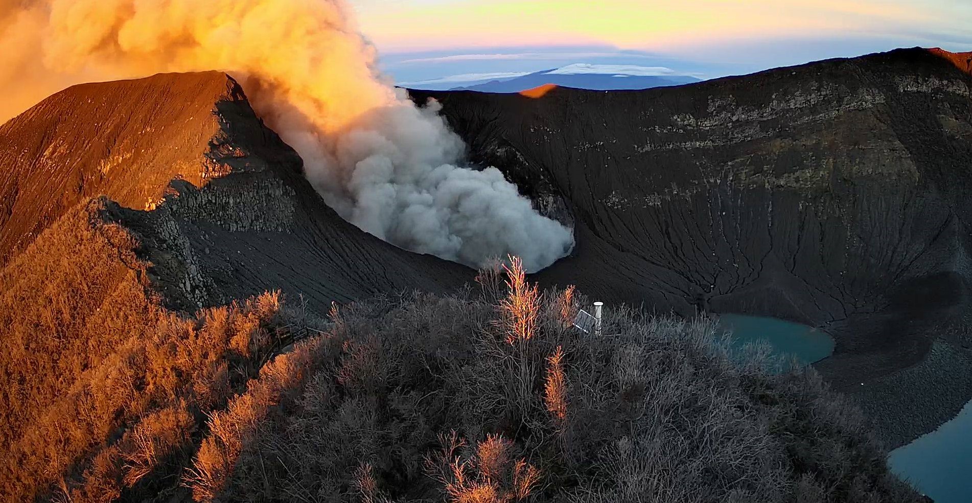
The Turrialba volcano showed a stable and weak state of activity. The column of water vapor and gas dispersed mainly to the western and southwestern sectors, with the exception of the early morning when it is transported to the northwest sector. The seismic activity is little dominated by discrete low frequency earthquakes. The presence of two lakes at the top of the volcano continues, with variations depending on the rain, while a third body of water forms a few hours after the rains, then disappears. The incandescence recorded by the volcanic surveillance cameras in the active crater continues as intense as the previous week. No major changes in seismicity were reported compared to the previous week.
Source : RSN , OVSICORI.
Photos : Waldo Taylor de ICE. RSN .
Indonesia , Merapi :
VOLCANO OBSERVATORY NOTICE FOR AVIATION – VONA.
Issued: November 17 , 2019
Volcano: Merapi (263250)
Current Aviation Colour Code: ORANGE
Previous Aviation Colour Code: orange
Source: Merapi Volcano Observatory
Notice Number: 2019MER04
Volcano Location: S 07 deg 32 min 31 sec E 110 deg 26 min 31 sec
Area: Special Region of Yogyakarta, Indonesia
Summit Elevation: 9498 FT (2968 M)
Volcanic Activity Summary:
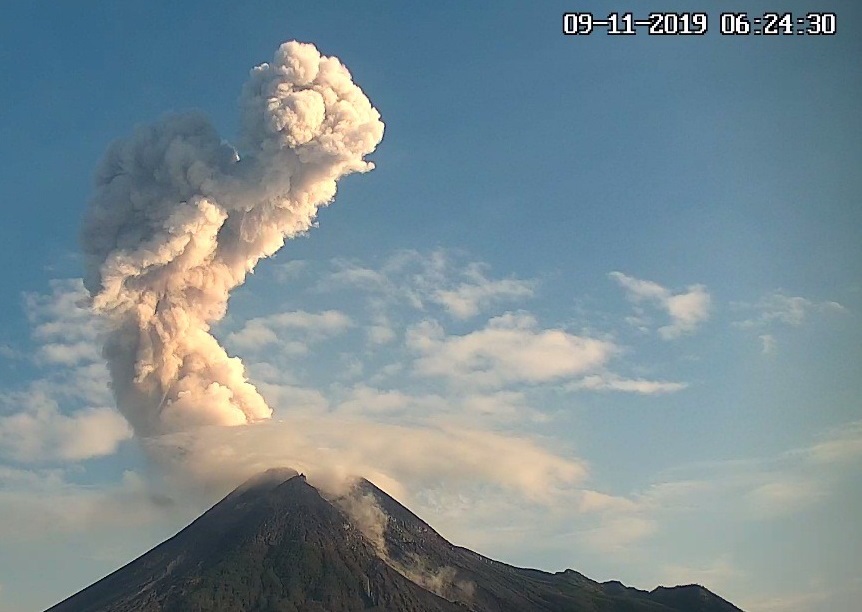
Eruption with ash cloud at 03h46 UTC (10h46 local), lasted for 155 seconds. Eruption has stopped.
Volcanic Cloud Height:
Best estimate of ash-cloud top is around 12698 FT (3968 M) above sea level, may be higher than what can be observed clearly. Source of height data: ground observer.
Other Volcanic Cloud Information:
Ash-cloud moving to west.
Remarks:
Eruption was recorded in seismograph for 155 s and amplitude 70 mm.
Source : Magma indonésie.
Photo : BPPTKG
El Salvador , San Miguel ( Chaparrastique) :
Special file n ° 2: persistence of the anomaly in the seismicity of the San Miguel volcano.
During the past week, the seismicity of the San Miguel volcano continued to show slight anomalies in the number of earthquakes and their frequencies. These changes are associated with high frequency events with a certain degree of impulsivity and a higher amplitude, related to the presence of small fractures in the duct of the volcanic system.
The activity of the volcano, for the moment, is not considered a danger for the population, but it indicates that there are variations in the equilibrium conditions of the system. These changes are continually monitored and, if conditions exist that indicate increased activity and potential danger, the population and the national civil protection system will be informed at a later date.
Figure 1 shows the seismicity recorded in the VSM station for the last 7 days.

Figure 1 Seismicity of the recorded volcano from 8 to 15 November 2019. Associated with the opening of cracks and ducts and the movement of gases and magma.
Figure 2 shows the record and classification of the microseismicity of the last 14 days. A slight increase in the number of earthquakes recorded daily is observed, and the presence of earthquakes associated with the opening of cracks and ducts is mainly observed because of the increase of the pressure in the internal system of the volcano.
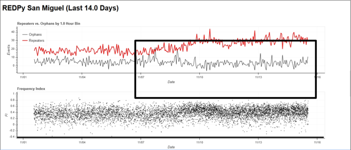
Figure 2. The black box shows a slight increase in the number of earthquakes. The black line divides the frequency index. Black dots above zero represent high frequency and subzero earthquakes, weak earthquakes, associated with opening of cracks and ducts due to pressure and fluid motions in the internal volcanic system.
The images captured by the volcanic surveillance camera located on the Pacayal volcano do not show the presence of gas or vapor coming from the crater and no abnormal situation reports were provided by the local network of observers … / …
Interpretation:
At present, the current activity of the volcano is dominated by the presence and prevalence of high-frequency earthquakes, highlighting the presence of cracks and ducts associated with changes in fluid and magma pressure. in the shallow part of the duct of the volcanic system. .
The next update will take place on Friday, November 22, 2019. In the event of a material change, a preliminary special report will be published.
Source : Marn.
Photo : Auteur inconnu.
Mexico , Colima :
Weekly technical bulletin of activity of the volcano Colima.
Date: November 15, 2019 Bulletin No. 147
Seismic activity:
During the last week, 6 high frequency events (HF), 2 landslides and 5.4 min of low amplitude tremors were automatically recorded.
Visual observations:
Intermittent steam and gas emissions from the northeast side of the crater continue to be recorded during the reporting period, but fumaroles were also observed in the western portion. When clouds allowed, the fixed thermal camera located south of the volcano recorded thermal anomalies associated with fumarole activity.
Source : UCOL.
Photo : proceso.com.mx


No comment yet, add your voice below!