
November 03 , 2019.
Japan , Satsuma-Iojima :
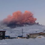
Volcano erupts on Satsumaio Island in southwest Japan.
A volcano erupted on Satsumaio Island in southwestern Japan on Saturday, the Japan Meteorological Agency said.
The eruption around 5:35 p.m. prompted the agency to raise the alert level for the volcano in Kagoshima Prefecture to 2 from 1 on a scale of 5, warning of the likelihood of flying rocks and pyroclastic flows within around a 1-kilometer radius of the crater.

There were no immediate reports of injuries, according to local authorities.
Kikai is a mostly submerged, 19-km-wide caldera near the northern end of the Ryukyu Islands south of Kyushu. Kikai was the source of one of the world’s largest Holocene eruptions about 6300 years ago. Rhyolitic pyroclastic flows traveled across the sea for a total distance of 100 km to southern Kyushu, and ashfall reached the northern Japanese island of Hokkaido. The eruption devastated southern and central Kyushu, which remained uninhabited for several centuries. Post-caldera eruptions formed Iodake lava dome and Inamuradake scoria cone, as well as submarine lava domes.
![]()
Historical eruptions have occurred in the 20th century at or near Satsuma-Iojima (also known as Tokara-Iojima), a small 3 x 6 km island forming part of the NW caldera rim. Showa-Iojima lava dome (also known as Iojima-Shinto), a small island 2 km east of Tokara-Iojima, was formed during submarine eruptions in 1934 and 1935. Mild-to-moderate explosive eruptions have occurred during the past few decades from Iodake, a rhyolitic lava dome at the eastern end of Tokara-Iojima.
Source : KYODO NEWS. GVP.
Photos : JMA , Ray_go – Own work, CC BY-SA 4.0, https://commons.wikimedia.org/w/index.php?curid=3602404
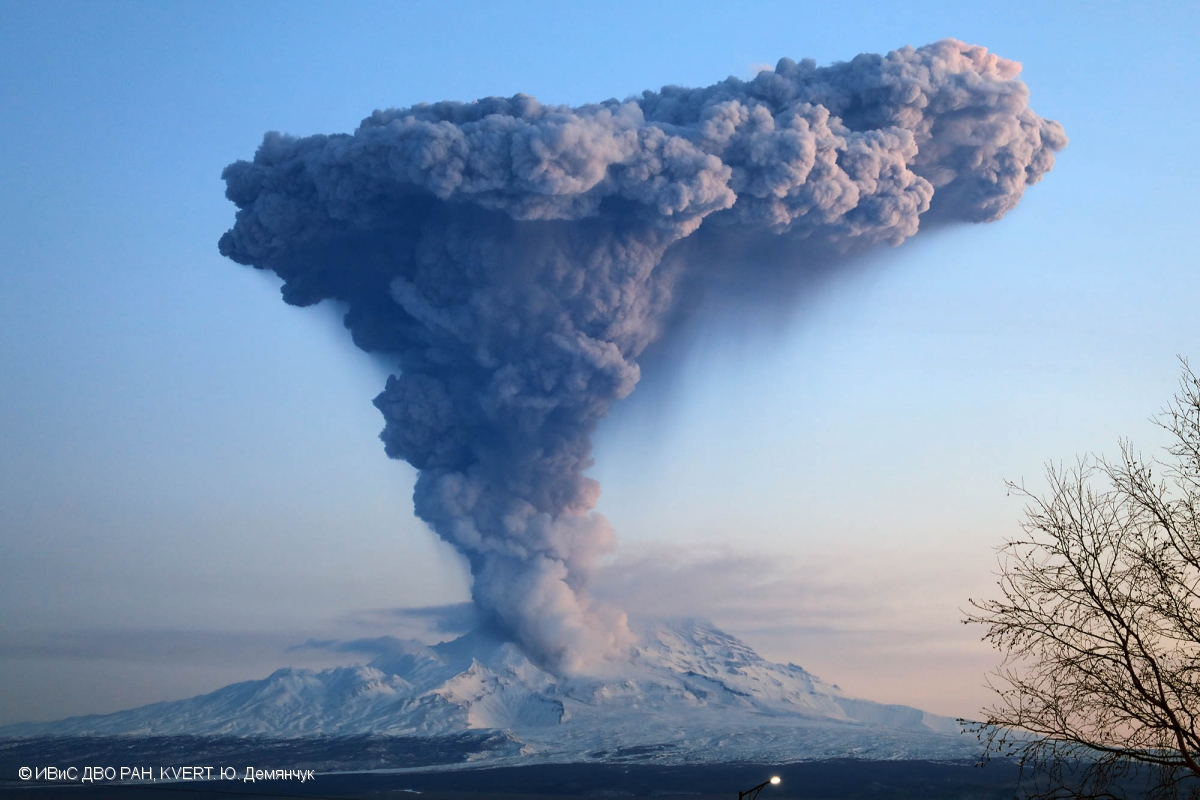
Kamchatka , Sheveluch :
VOLCANO OBSERVATORY NOTICE FOR AVIATION (VONA).
Issued: 20191103/0546Z
Volcano: Sheveluch (CAVW #300270)
Current aviation colour code: RED
Previous aviation colour code: orange
Source: KVERT
Notice Number: 2019-167
Volcano Location: N 56 deg 38 min E 161 deg 18 min
Area: Kamchatka, Russia
Summit Elevation: 10768.24 ft (3283 m), the dome elevation ~8200 ft (2500 m)
Volcanic Activity Summary:
A growth of the lava dome continues, a strong fumarolic activity and an incandescence of the dome blocks and hot avalanches accompanies this process. According to satellite data, an ash cloud up to 10 km a.s.l. drifted to the north-west from the volcano.
Explosive-extrusive eruption of the volcano continues. Ash explosions up to 32,800-49,200 ft (10-15 km) a.s.l. could occur at any time. Ongoing activity could affect international and low-flying aircraft.
Volcanic cloud height:
31160-32800 ft (9500-10000 m) AMSL Time and method of ash plume/cloud height determination: 20191103/0520Z – Himawari-8
Other volcanic cloud information:
Distance of ash plume/cloud of the volcano: 50 mi (81 km)
Direction of drift of ash plume/cloud of the volcano: NW / azimuth 313 deg
Time and method of ash plume/cloud determination: 20191103/0520Z – Himawari-8
Source : Kvert.
Photo : Yu. Demyanchuk, IVS FEB RAS, KVERT ( 12/2017).
Ecuador , Reventador :
The Reventador volcano emits gas columns of more than a thousand meters.
The Ecuadorian volcano Reventador, located 90 kilometers from the country’s capital, Quito, has issued columns of gas and ash at a height of more than a thousand meters above the crater, announced this Friday 1st November, the Institute of Geophysics of the National Polytechnic School. « There were several emissions of gas and ash exceeding a thousand meters above the crater level, the direction of the column of emission went from West to South-West, » said the Institute. He added that in the afternoon of Thursday, the area was discovered, which allowed to observe the emissions. « At night, the weather was clear, an incandescence was observed in the crater.Today, in the morning, the area became cloudy again, » noted the Institute of Geophysics. In November 2002, an eruption of the Reventador volcano caused the formation of a vast cloud of ashes which, because of the winds, had moved on Quito and covered several parts of the capital.
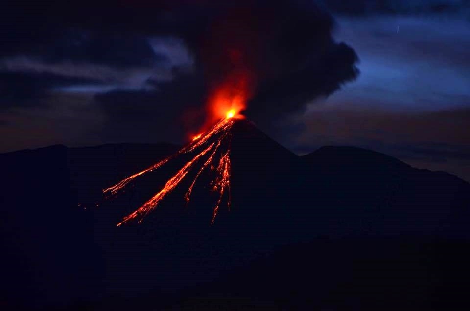
Yesterday afternoon, the volcano was cleared and an ash emission was observed westward, at an altitude of 1,000 meters above the summit.
Other monitoring parameters: No change.
Observations:
During the night and early in the morning, the volcano was clear most of the time and several ash emissions could be observed west and north with a maximum height of 700 meters above the crater, accompanied by descent of blocks of up to 800 meters below the summit crater, on all sides of the volcano. The weather is currently cloudy.
Source : EL TELÉGRAFO , IGEPN .
Lire l’article : https://www.eltelegrafo.com.ec/noticias/quito/1/volcan-reventador-columnas-gas?fbclid=IwAR1-UKtPK4NfOditxAYGcEAwwd5J-wYKBadBqF4r8yBClNSVgvCkA-Szf5o
Photo : Juan Carlos ( 2015 ).
Costa Rica , Turrialba / Poas / Rincon de la Vieja :
Daily report on the state of volcanoes. Date: 02 November 2019, Updated at: 10:51:00.
Turrialba Volcano:
No eruption is reported.
The seismic activity is similar to that of yesterday.
At the time of this report, the winds are blowing west.
Passive and stable degassing is observed.
On October 28, at 15:01, the Turrialba volcano presented a small eruptive pulse with a slow release of ashes. This event lasted about 5 minutes and did not generate reports of ash drop. Most likely, the ashes remained in the West Zone near the Turrialba volcano. The rest of the week showed a stable and weak state of activity. The column of water vapor and gas dispersed mainly to the western and southwestern sectors, with the exception of the early morning when they were transported to the northwest sector. The seismic activity is little dominated by discrete low frequency earthquakes. The presence of two lakes at the top of the volcano continues, with variations depending on the rain, while a third body of water forms a few hours after the rains, then disappears. The incandescence recorded by the volcanic surveillance cameras in the active crater remains as intense as the previous week. No major changes in seismicity were reported compared to the previous week. The public is reminded that the entrance to the Turrialba Volcano National Park, which coincides with a radius of 2 km around the active crater, is closed due to the activity of the volcano. Approaching the crater means a very high risk activity.
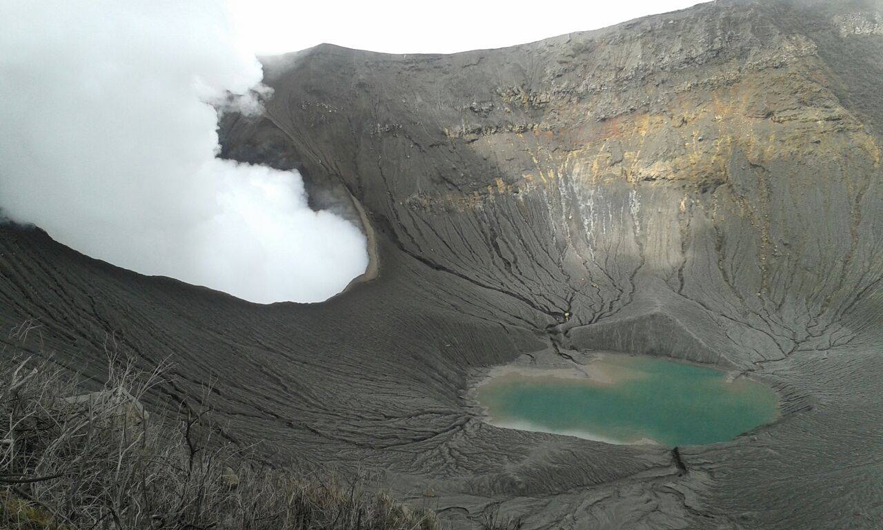
Poas Volcano:
No eruption is reported.
The seismic activity is similar to that of yesterday.
At the time of writing, winds are blowing from the southwest.
No noticeable change. Flooded mouths A and C are observed by the lagoon and moderate and stable degassing / evaporation. The concentration of SO2 towards the point of view did not exceed 3 ppm.

On this photograph of the Poás volcano, there is a lake that has grown compared to the previous week, with the water covering the area of the mouth a, mouth b and is very close to the Sector of the vents. In addition, the processes of evaporation and exit of gases were intense during the last week.
The lake that had been forming since last week stayed and grew during this week. The evaporation processes were intense, especially on Friday, October 25, and could be observed through the volcanic surveillance camera as columns of water vapor and volcanic gas rose from the lake throughout the day. The field of fumaroles rich in sulfur in the North-East sector maintains its activity of expiration. At the seismic level, the background tremor of low amplitude (2 to 4.5 Hz) was maintained, as well as discrete events of type LP (long period) also of low amplitude.
Rincon de la Vieja Volcano:
No eruption is reported.
The seismic activity is similar to that of yesterday.
The wind direction is unknown at the moment.
No visibility at the top due to cloudy weather.

The seismic activity continued with the appearance of a large number of long-period (> 5 tens) and volcano-tectonic (nearly a dozen) signals, the vast majority of them recorded in more than two seismological stations. A continuous spasmodic tremor appeared again on October 17th and lasted until October 27th.
It is recommended to stay away from the canals of rivers near the volcano in case of eruption, because of the possibility of generating primary lahars. In addition to the rains, ashes and accumulated material in the upper parts of the volcano could generate secondary lahars.
Source : OVSICORI , RSN.
Photos : RSN , RSN , Federico Chavarría-Kopper – Ovsicori.


No comment yet, add your voice below!