
Octobre 26 , 2019.
La Réunion , Piton de la Fournaise :
Activity bulletin of October 25, 2019 at 3:15 pm (local time).
Following the seismic crisis started at 0:15 local time, the volcanic tremor, which is synonymous with the arrival of magma near the surface, has been recorded since 2:40 pm (and not 4h40 as indicated in the first version) around local time.
No visual confirmation of a start of eruption could be made for the moment on the webcams because of the location of the eruption and we can not confirm the arrival of the lava on the surface. Nevertheless the presence of a tremor shows the emission of hot and incandescent gas on the surface, and the possibility of lava emission in the short term.
Eruption in progress.
Further information will follow regarding the area impacted by this magmatic spread to the surface.
Activity bulletin of October 25, 2019 at 1:00 am (local time).
The eruption, which began at 2:40 pm local time, continues. The intensity of the eruptive tremor (related to the flow of lava at the level of the vent) has been stable since the beginning of the eruption.
The eruption started today at 2:40 pm (local time) continues. The intensity of the eruptive tremor (a witness of the intensity of the eruption) has been stable since the beginning of the eruption (Figure 1).
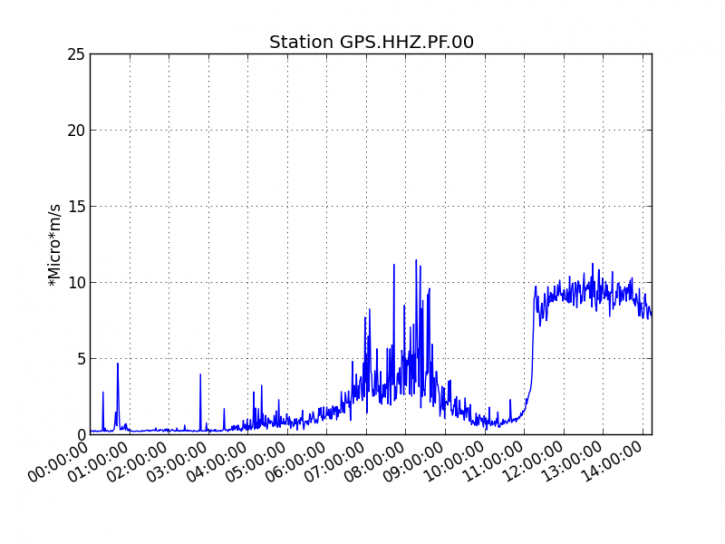
Figure 1: Evolution of the RSAM (indicator of the volcanic tremor and the intensity of the eruption) between 04:00 (00:00 UTC) on October 25 and 18:24 (14:24 UTC) on October 25, 2019 on the GPS seismic station, station most near the eruptive site.
The first field observations report 2 active cracks that opened in the southern part of the Enclos Fouqué about 1km north of the southern rampart and around 1400 m altitude.
At the beginning of the eruption, several casting arms could be observed. The front of the most active flow was at 17h00 to 2 km upstream of the RN2 (Figure 2) on the 2007 flow, a hundred meters downstream of Piton Tremblet. The progress of the flow front remains conditioned by the flow of lava at the level of the vent.
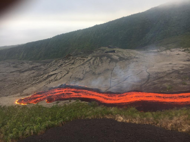
Figure 1: Front flow around 17:00 at the Piton Tremblet – Photo PGHM
The lava near the National Highway.
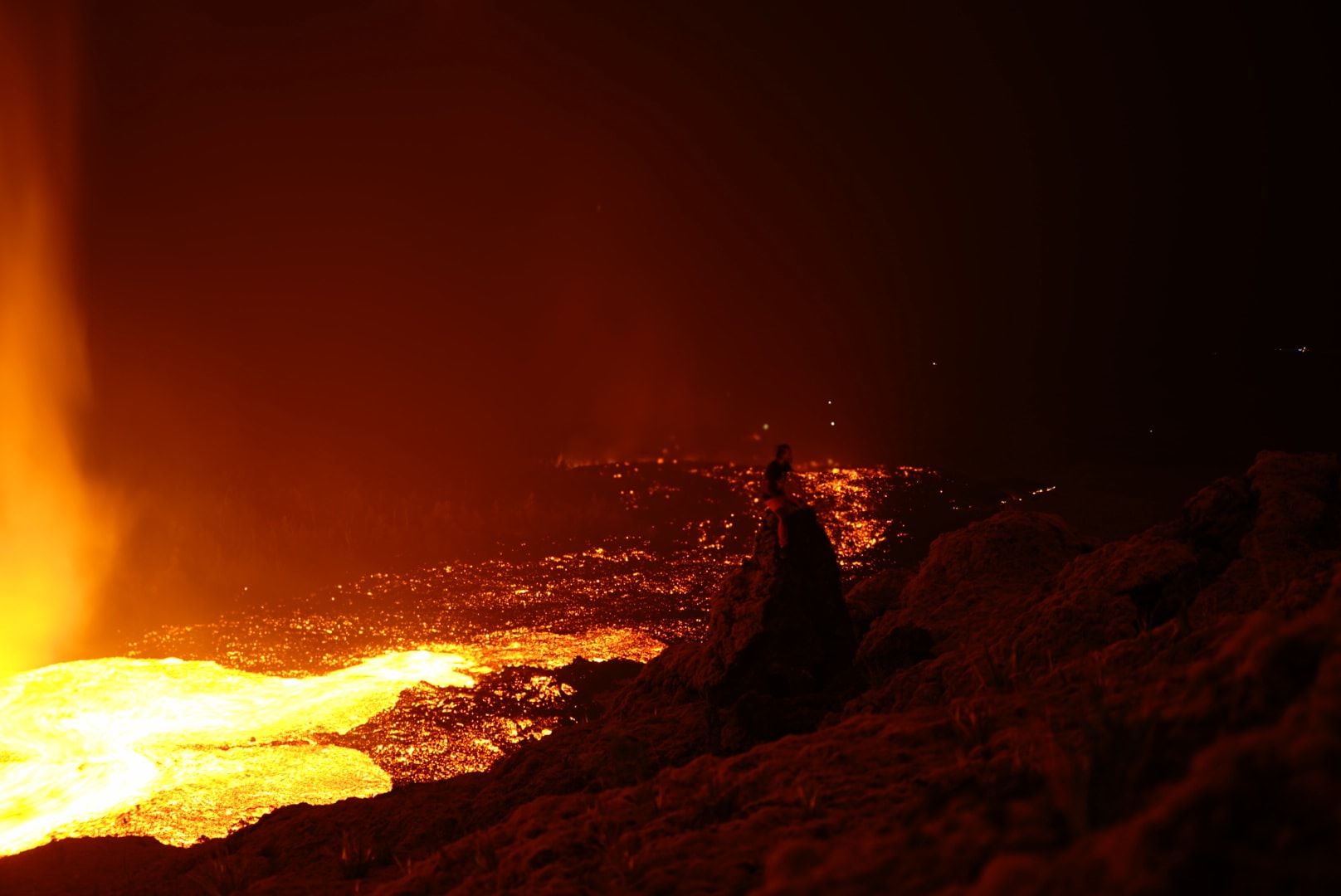
The lava had not been so close to the RN2 since 2007. At 8am this Saturday, October 26 morning, the flow was 400 meters from the national highway. If the eruption had begun on a run with a flow that swept down the great slopes at high speed V, since the middle of the night, things have changed. The flow of the eruptive tremor has decreased, and on its way, the lava must face a denser vegetation and a shelf that slow down the progress of the flow.
« Scientists went on site this Saturday morning and made the first samples, » said Aline Peltier, director of the observatory Piton de la Fournaise before adding « both arms are still active, one along the 2007 and the other is located in the forest is the furthest flow .The eruptive site is halfway down.
Source : OVPF . http://www.ipgp.fr/fr/ovpf/bulletin-dactivite-25-octobre-2019-a-15h15-heure-locale , IP Reunion ,
Vidéo : Imaz Press Réunion .
Photo : Imaz Press Réunion . Tunnels de lave Réunion : Rando-Volcan
Chile , Nevados de Chillan :
Seismic activity:
In the past 24 hours, CVNCh’s instrumental monitoring network has continued to record episodes of volcano-tectonic (VT), long-period (LP), very long-lived (VLP) type seismicity. tremor (TR), releasing high seismic energy Seismicity of type LP and TR is frequently related to the occurrence of explosions (EX), which cause surface activity.
Observations:
The higher-energy volcano-tectonic event was located 2.7 km south of Nicanor Crater, 4.4 km deep.
With the exception of the maximum explosion, the images from the fixed cameras detected, in general, a column of low gas, of low height and rather intermittent with whitish tones. During the night, no surface activity was observed from the active crater.
Other observations
According to recent images, a new lava flow was observed from the Nicanor Crater, to the Northeast Slope (NE) from October 16th. It continued its progression very slowly, with a lower rate of displacement, compared to the flux reported in previous weeks. The network of GNSS stations installed on the volcanic complex recorded a maximum increase in the length of the control lines crossing the active crater of 3.6 ± 0.1 cm; The elongation rate over the last 30 days is 0.9 ± 0.05 cm / month. During this period, the uprising continues in all monitoring stations. The vertical lift rate for the last 30 days is 1.7 ± 0.3 cm / month, at the closest station to the active crater located 1.5 km away.
The MIROVA group (3) reported thermal anomalies, with a maximum power of 3 MW located on the active crater. Infrasound sensors recorded acoustic signals associated with explosions (EX), with maximum values up to 6 Pascals (Pa) reduced to 1 km.
Source : Sernageomin.
Photo : SERNAGEOMIN
Alaska , Shishaldin :
54°45’19 » N 163°58’16 » W,
Summit Elevation 9373 ft (2857 m)
Current Volcano Alert Level: WATCH
Current Aviation Color Code: ORANGE
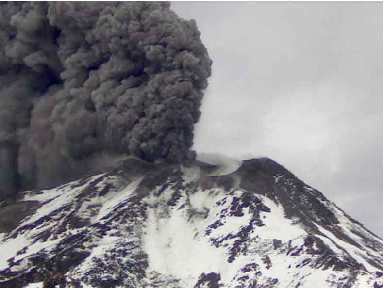
Low-level eruptive activity continues at Shishaldin Volcano and now extends beyond the summit crater. Lava flows filled the summit crater over the past week and small flows overtopped the crater rim and flowed ~800 m (0.5 miles) down the northern slope by Thursday, October 24. Minor explosive activity with regular bursts of lava fountaining within the summit crater has been observed throughout the past week, depositing lava spatter around the summit in addition to a trace ash deposit that extends at least 8.5 km (5.3 miles) the southeast.
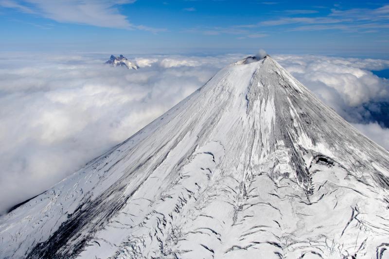
Aerial view of Shishaldin Volcano with Isanotski Volcano in the background taken from a helicopter overflight during geology field work.
A small steam plume has been visible over the past week as well. Melting of snow by lava and spatter has produced lahars that extend up to ~3 km (1.9 miles) down the northwest slope, with shorter lahars to the north and east. Low-level seismicity and infrasound signals continued to be observed on the local network throughout the past week.
Shishaldin is monitored by local seismic and infrasound sensors, satellite data, a web camera, a telemetered geodetic and tilt network, and distant infrasound and lightning networks.
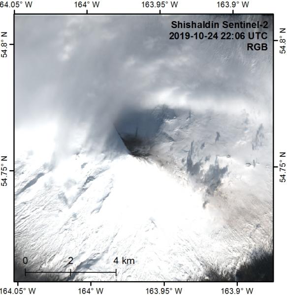
This clear view of Shishaldin in a Sentinel-2 image from 10/24/2019 shows incandescence in the summit crater with a very small steam plume. The summit crater is filled with lava that is escaping the crater rim to the NW and feeding a ~800-m-long lava flow. This in turn feeds a lahar extending below the cloud deck out of view. No other lava flows beyond the summit crater are apparent, but another lahar to the NNE extends about 1.3 km downslope. The summit area is darkened by deposits to about 800 m radius to the north with small lahars extending a similar distance to the east. The dark streak of an ash deposit extends at least 8.5 km to the SE.
Shishaldin Volcano, located near the center of Unimak Island in the eastern Aleutian Islands, is a spectacular symmetric cone with a base diameter of approximately 16 km (10 mi). A 200-m-wide (660 ft) funnel-shaped summit crater typically emits a steam plume and occasional small amounts of ash. Shishaldin is one of the most active volcanoes in the Aleutian volcanic arc, with at least 54 episodes of unrest including over 24 confirmed eruptions since 1775. Most eruptions are relatively small, although the April-May 1999 event generated an ash column that reached 45,000 ft above sea level.
Source : AVO.
Photo : Loewen, Matt 08/2018 , Dietterich, Hannah , 24 Octobre 2019.
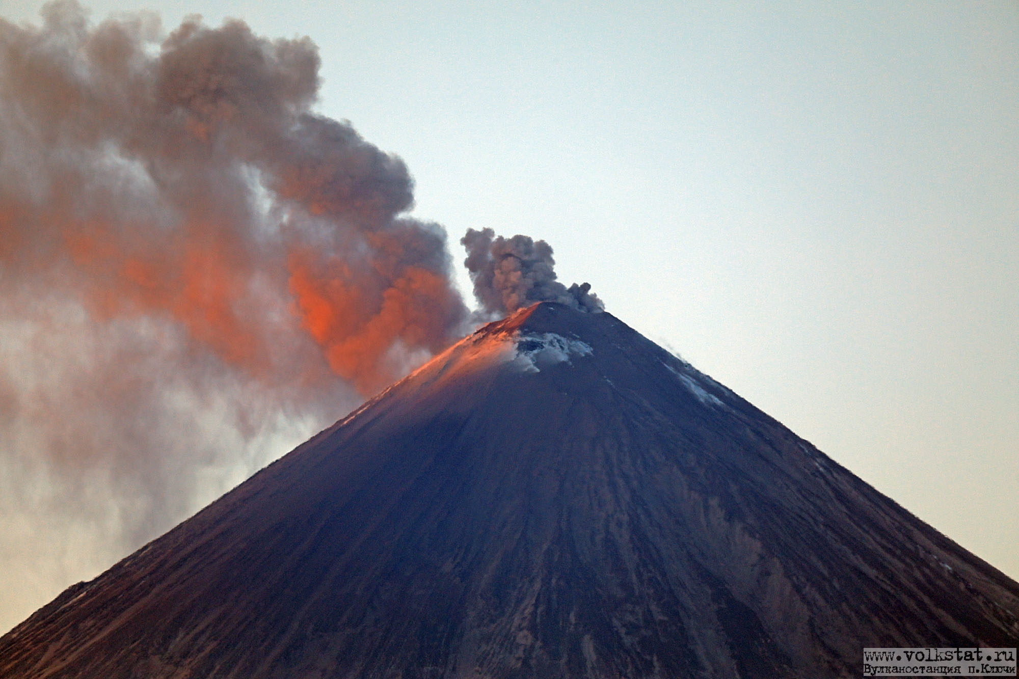
Kamchatka , Klyuchevskoy :
VOLCANO OBSERVATORY NOTICE FOR AVIATION (VONA).
Issued: October 25 ,2019
Volcano: Klyuchevskoy (CAVW #300260)
Current aviation colour code: ORANGE
Previous aviation colour code: orange
Source: KVERT
Notice Number: 2019-164
Volcano Location: N 56 deg 3 min E 160 deg 38 min
Area: Kamchatka, Russia
Summit Elevation: 15580 ft (4750 m)
Volcanic Activity Summary:
A moderate gas-steam with some amount of ash activity of the volcano continues. According to video data, ash plume is extending for 15 km to the south-east of the volcano.
This activity of the volcano continues. Ash explosions up to 16,400-23,000 ft (5-7 km) a.s.l. could occur at any time. Ongoing activity could affect low-flying aircraft.
Volcanic cloud height:
16400-18040 ft (5000-5500 m) AMSL Time and method of ash plume/cloud height determination: 20191025/0028Z – Video data
Other volcanic cloud information:
Distance of ash plume/cloud of the volcano: 9 mi (15 km)
Direction of drift of ash plume/cloud of the volcano: SE
Time and method of ash plume/cloud determination: 20191025/0028Z – Video data
Source : Kvert.
Photo : Volkstat ru / Yu Demyanchuck.


No comment yet, add your voice below!