
October 16 , 2019.
Colombia , Nevado del Huila :
Weekly activity bulletin of the Nevado del Huila volcano.
The level of activity of the volcano continues at the level: Activity level Yellow or (III): changes in the behavior of volcanic activity.
According to the analysis and evaluation of information obtained through the surveillance network of the Nevado del Huila volcano, during the week of October 8 to 14, 2019, the Colombian Geological Service – Volayological and Volatological Observatory of Popayán informs that :
During the evaluated period, 325 seismic events were recorded, of which 150 were related to rock fracturing processes (type VT) and 175 to fluid dynamics in volcanic conduits. Of these, 174 have been cataloged as long-period events (type LP) and one (1) as hybrid signals (type HB).
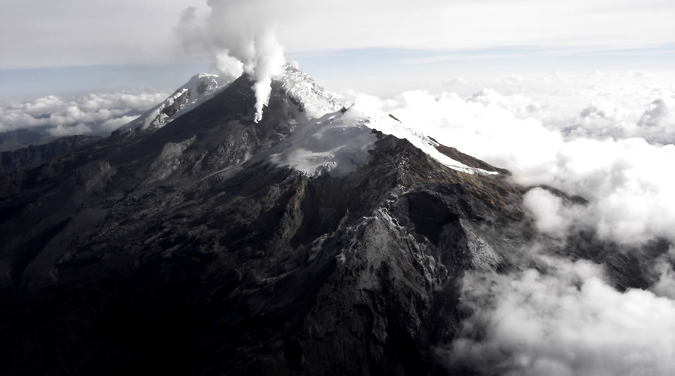
On October 11, a mobile measurement of SO2 emissions was carried out on the Nevado del Huila volcano, between the roads of Popayán and Puerto Tejada (Cauca). The gas column was detected between the populations of Popayán and Mondomo (Cauca) and the calculated flow rate was 586 t / day, which is considered low.
The images obtained during the week by the webcams of Caloto, Tafxnú, Maravillas and La Palma showed a weak degassing of the volcanic system.
Sensors to monitor soil deformation, magnetic fields and infrasound waves have not recorded any variations associated with changes in volcanic activity.
Therefore, it is concluded that the volcano continued to exhibit stable behavior during the evaluated period. The Colombian geological service remains attentive to the evolution of the volcanic phenomenon and will inform in due time any changes that may occur.
Source : SGC.
Photo : Parque Nacional
Peru , Sabancaya :
Period of analysis: October 7 to 13, 2019. Arequipa, October 14, 2019.
Alert level: ORANGE
The Geophysical Institute of Peru (IGP) reports that the eruptive activity of the Sabancaya volcano has remained at moderate levels; that is, with the recording of continuous moderate explosions and the resulting ash and gas emission. Therefore, for the following days, no significant change in the level of activity is expected.
The analysis of records obtained from the seismic network of the Sabancaya volcano for the period from 7 to 13 October 2019 identified the occurrence of about 1983 earthquakes of volcanic origin, the highest percentage of which was associated with movements of magmatic fluids (gas and magma). During this week, an average of 36 explosions per day of average to low intensity were observed.

The monitoring of the deformation of the volcanic structure, using GNSS data (processed with fast orbits), presents no significant anomalies; nevertheless, there is still slight inflation in the northern sector of the volcano, a deformation observed since the beginning of the eruptive process. Visual surveillance, using surveillance cameras, allowed us to identify the appearance of columns of gas and ash up to 3.5 km high above the top of the volcano, which dispersed in the areas Southwest and Southeast of Sabancaya. Satellite monitoring has identified 15 volcanic anomalies on the volcano, ranging from 1 to 50 MW, associated with the presence of a hot body inside the volcano’s crater.
Source : Cenvul.
Photo : Ingemmet.
Indonesia , Karangetang :
Level of activity at Level III (SIAGA). G. Karangetang (1,784 m above sea level) has been re-erupted since November 25, 2018.
Cloudy to rainy, weak winds east and south. The temperature is about 25 to 32 ° C. The volcano is clearly visible until it is covered with fog. Smoke from the main crater is observed to be white with a low, thick intensity about 400 meters above the summit.
The seismographs, on October 15, 2019, recorded:
149 avalanche earthquakes.
15 earthquakes of explosions
1 hybrid earthquake
3 shallow volcanic earthquakes
3 distant tectonic earthquakes
Continuous tremor with an amplitude of 0.25 to 7 mm, a dominant value of 3 mm.
Recommendations:
The public and visitors / tourists are advised not to travel within 2.5 km of the main crater (South) and crater II (North), as well as in the sectoral expansion zone of Crater II. northwest 4 km and from the main crater west up to 3 km.
Communities living around rivers that originate at the summit of Mount Karangetang need to be prepared for the potential threat of lahars and sudden floods that can spread to the coast.
VONA: The latest VONA color code, Yellow, was issued on November 25, 2018 at 13:32, for volcanic ash emissions at an altitude of approximately 2,284 meters above sea level or approximately 500 meters above sea level. meters above the summit, the wind was blowing to the east.
Source : PVMBG.
Video : Streaming Planet / Marc Szeglat .
Guatemala , Fuego :
Atmospheric conditions: Cloudy
Wind: South East
Precipitation: 38.2 mm
Activity:
Presence of weak white color degassing at an approximate height of 4,300 meters above sea level (14,108 feet) dispersed in a westerly and southwesterly direction. There are 6 to 14 ash emissions with weak to moderate characteristics. The column of ash has an approximate height of 4,500 to 4,800 m altitude moving 10 to 15 km to the west and southwest.
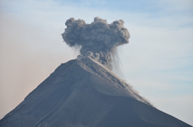
Low to moderate rumblings are recorded, as well as low to moderate shock waves causing vibrations in the roofs and windows of homes near the volcano. Weak sounds similar to those of a locomotive with intervals of 3 to 5 minutes, associated with degassing are heard. In the evening and early morning, incandescence was observed in the crater at an approximate height of 200 to 300 meters above the crater, causing weak to moderate avalanches on the crater contour, some reaching long distances to the crater. the vegetation towards the ravines: Seca, Ceniza and Las Lajas. The ashes fall among other things in: Morelia, Santa Sofia, El Porvenir, Sangre de Cristo, San Pedro Yepocapa, Panimaché I and II.
Source : Insivumeh
Photo : Nath Duverlie


No comment yet, add your voice below!