
October 10 , 2019.
Chile , Copahue :
Previous alert level: ORANGE
Current alert level: YELLOW
Seismic activity:
Over the past 24 hours, the Copahue Volcano Monitoring Network has continued recording volcano-tectonic (VT) earthquakes, long-period (LP) and continuous tremor (TRc) earthquakes, related to volcanic activity in the Caviahue caldera.

Observations:
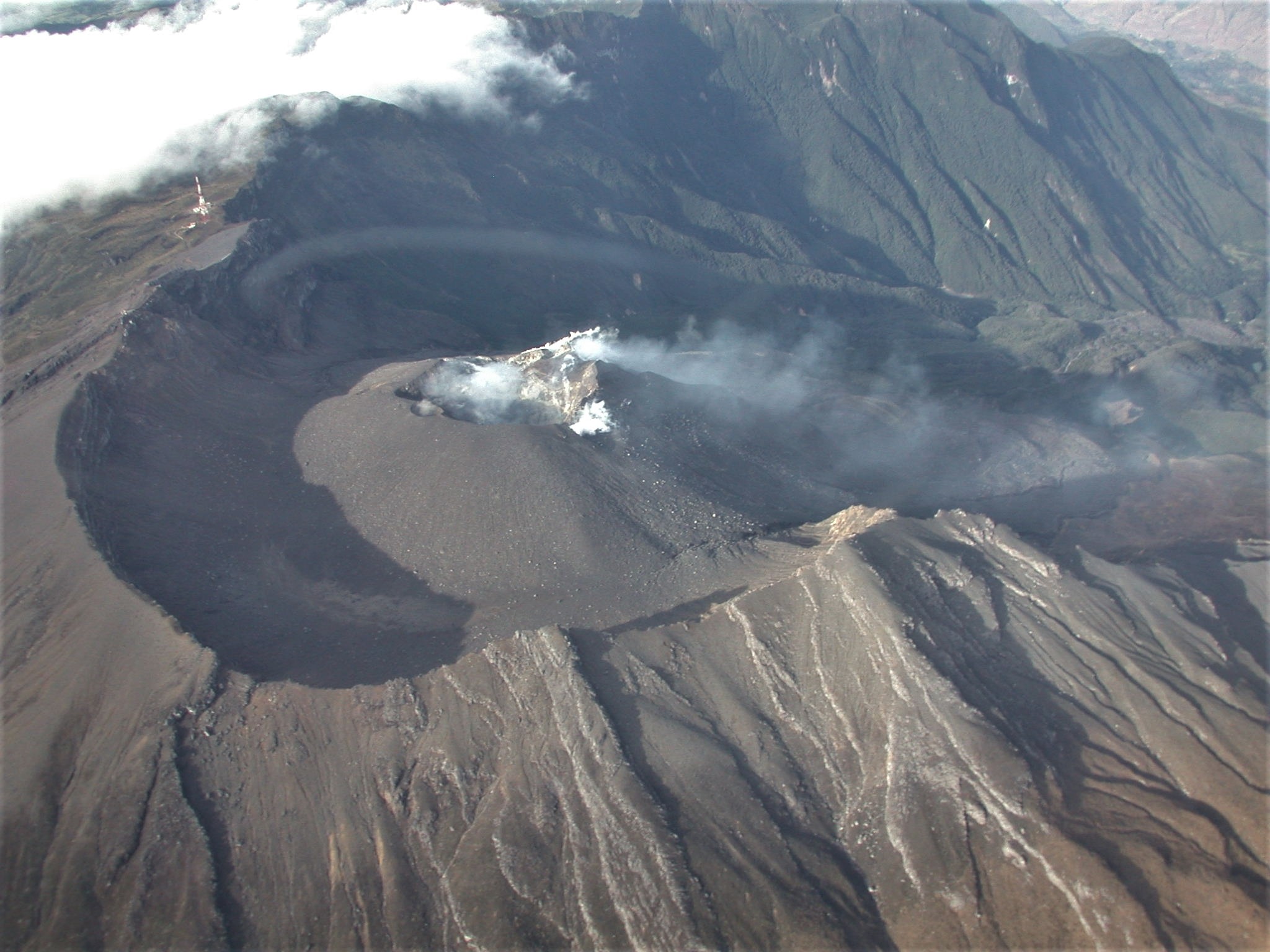
The most energetic volcano-tectonic event was 9.2 km northeast of El Agrio Crater, with a depth of 1.9 km. For a few hours, it was possible to detect a surface activity, where a column of gas was observed, mainly of gray color, suggesting particulate matter in its contents.
With regard to surface activity, pulsatile explosions were detected at the active crater, of low magnitude, with eruptive columns of moderate height whose products had a preferential dispersion towards the East. To date, the total area affected by the fall of the pyroclasts is 24.39 km2, the maximum dispersion distance being 6 km eastward and 5 km westward.
Due to the aforementioned emission of material from the Agrio crater during the last period, the construction of a pyroclastic cone in the same crater has been identified. Its diameter to date is 130 m in the West-East direction. The process of construction of this volcanic morphology had been recognized during earlier episodes of activity on the Copahue volcano.
Source : Sernageomin.
Photo : Dario G. Lazo ( http://www.idean.gl.fcen.uba.ar/2019/02/22/gigantes-de-fuego-cien-anos-despues/ ) .
Colombia , Galeras :
Weekly newsletter of Galeras Volcano.
The level of activity of the volcano continues at the level: YELLOW LEVEL ■ (III): CHANGES IN THE BEHAVIOR OF THE VOLCANIC ACTIVITY.
Following the activity of the GALERAS volcano , the COLOMBIAN GEOLOGICAL SERVICE (SGC) reports that:
For the period evaluated between October 1 and 7, 2019, the seismic activity in the Galeras volcano influence region recorded a stability in the daily occurrence, but an increase in the energy released by the events associated with the fracture of cortical material inside the volcanic building. These earthquakes have been scattered over the volcano at distances of up to 11 km, depths of less than 12 km from the summit (4,200 m altitude), and a local magnitude of up to 1,1 km. Richter scale.
Favorable climatic conditions have allowed, for most of the week, small gas emissions mainly from the El Paisita and Las Chavas fumarole fields north and west respectively of the main crater. These emissions were white in color, low in height and variable in direction depending on the action of the winds.
Other geophysical and geochemical parameters of volcanic monitoring did not show significant variations.
The COLOMBIAN GEOLOGICAL SERVICE remains attentive to the evolution of the volcanic phenomenon and will continue to report the changes observed as soon as possible.
Source et photo : SGC .
Japan , Sakurajima ( Aira) :
31.593°N, 130.657°E
Elevation 1117 m
JMA reported that incandescence from Minamidake crater (at Aira Caldera’s Sakurajima volcano) was occasionally visible at night during 30 September-7 October. The sulfur dioxide emission rate was high, at 2,000 tons/day, measured during fieldwork on 1 October. An explosion was recorded at 0055 on 4 October but weather clouds prevented visual confirmation. Two explosions during 6-7 October generated ash plumes that rose as high as 2.4 km above the crater rim and ejected large blocks 1.1 km away. The Alert Level remained at 3 (on a 5-level scale).
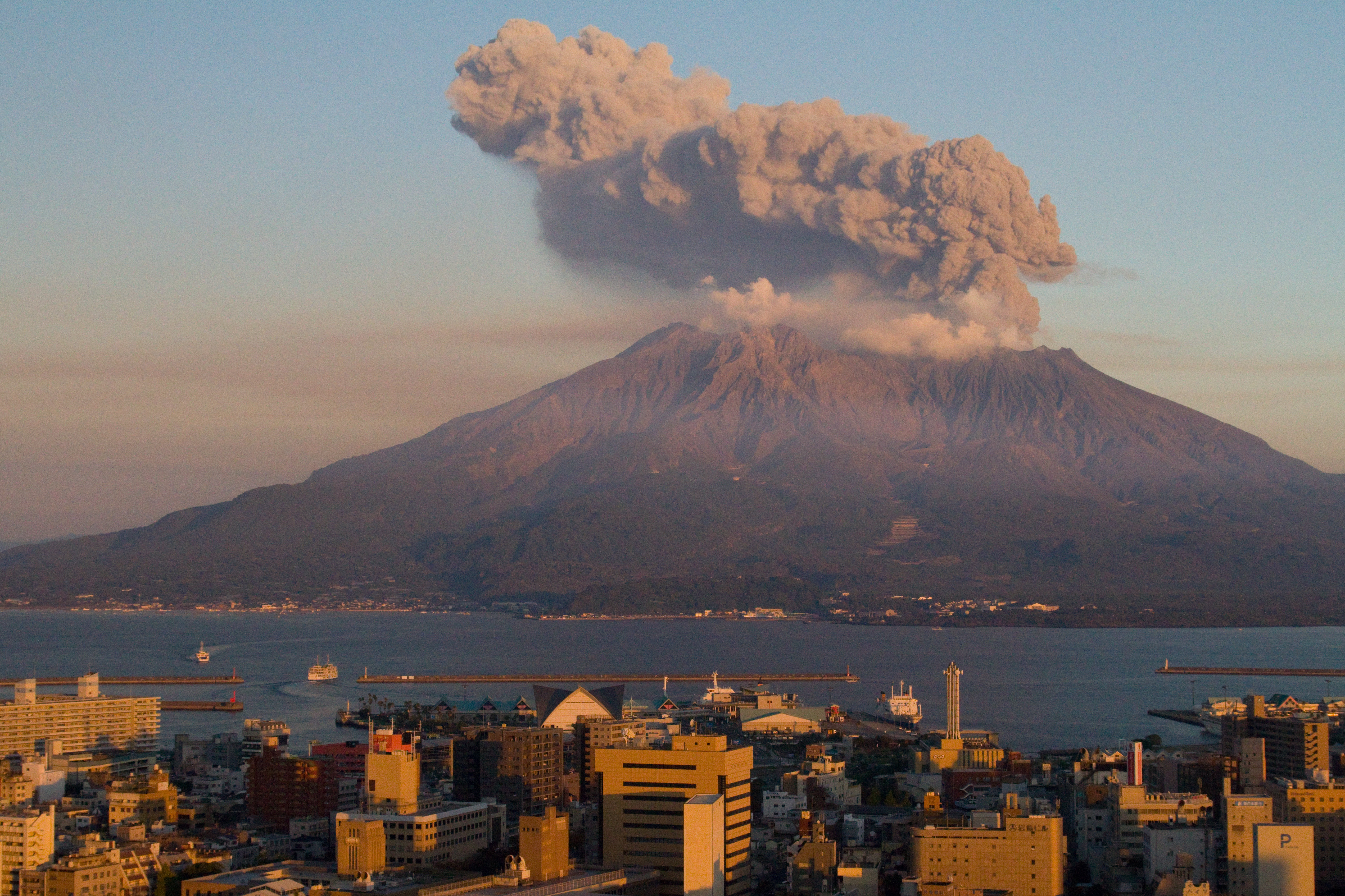
The Aira caldera in the northern half of Kagoshima Bay contains the post-caldera Sakurajima volcano, one of Japan’s most active. Eruption of the voluminous Ito pyroclastic flow accompanied formation of the 17 x 23 km caldera about 22,000 years ago. The smaller Wakamiko caldera was formed during the early Holocene in the NE corner of the Aira caldera, along with several post-caldera cones. The construction of Sakurajima began about 13,000 years ago on the southern rim of Aira caldera and built an island that was finally joined to the Osumi Peninsula during the major explosive and effusive eruption of 1914. Activity at the Kitadake summit cone ended about 4850 years ago, after which eruptions took place at Minamidake. Frequent historical eruptions, recorded since the 8th century, have deposited ash on Kagoshima, one of Kyushu’s largest cities, located across Kagoshima Bay only 8 km from the summit. The largest historical eruption took place during 1471-76.
Source:Japan Meteorological Agency (JMA). GVP.
Photo : wikipedia , Kimon Berlin.
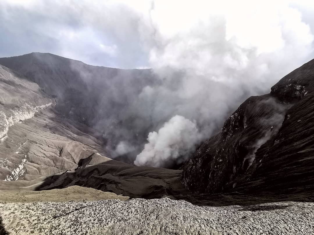
Indonesia , Dukono :
Level of activity at Level II (WASPADA). G. Dukono (1229 m altitude) is experiencing a continuous eruption.
Cloudy to rainy, light to moderate winds from North and Northeast. The temperature is about 24 to 29 ° C. The volcano is clearly visible until it is covered with fog. It is observed that the smoke from the main crater goes from white to gray with a strong intensity, thick, rising up to about 400 meters above the summit.
Through the seismographic recordings of October 9, 2019, we noted:
3 distant tectonic earthquakes
Continuous tremor with an amplitude of 0.5 – 12 mm and a dominant value at 4 mm.
Recommendation:
The community around G. Dukono and visitors / tourists should not climb or approach the Malupang Warirang crater within 2 km.
VONA:
The last VONA code was sent with the color code ORANGE, published on October 6, 2019 at 09:42, corresponding to an eruption with a height of the eruption column about 700 m above the summit or 1929 meters above sea level. The eruption column was moving south.
Source : PVMBG
Photo : Rainwater Media via Sherine France.


No comment yet, add your voice below!