
August 25 , 2019.
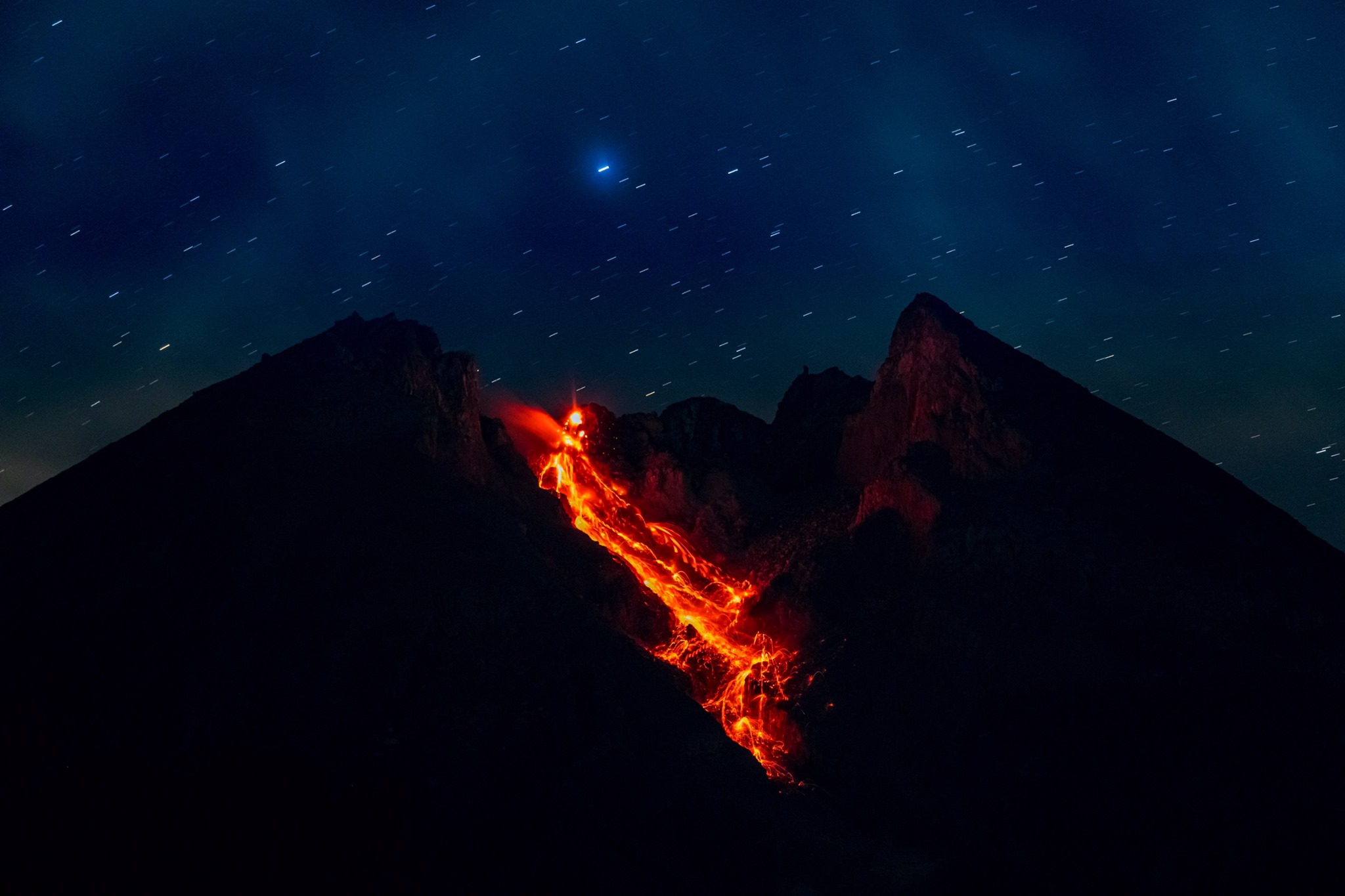
Indonesia, Merapi :
REPORT OF ACTIVITIES OF MOUNT MERAPI 16-22 August 2019 .
I. RESULTS OF OBSERVATION.
Visual:
The weather around Mount Merapi is usually sunny in the morning and evening, while the afternoon until evening is cloudy and foggy. White smoke is observed, thin to thick with low pressure. A maximum smoke height of 350 m was observed from the Mount Merapi observation post in Kaliurang on August 20, 2019 at 09:03.
The morphological analysis of the crater area based on photographs of the Southeast sector revealed no significant morphological changes. The volume of the lava dome based on aerial photo analysis with drones on August 8, 2019 was 461,000 m3. Since January 2019, the volume of the lava dome has remained relatively stable, as magma extrusion has largely collapsed directly upstream of Kali Gendol in the form of lava landslides and hot clouds.
In one week, there were 3 episodes of hot avalanche clouds with a maximum slip distance of 900 meters upstream of Kali Gendol.
Earthquake :
During this week, the seismicity of Mount Merapi recorded:
3 hot avalanche earthquakes (AP),
7 earthquakes (DG),
1 deep volcanic earthquake (VTA),
4 shallow volcanic earthquakes (VTB),
23 multiple phase earthquakes (MPs),
101 avalanche earthquakes (RF),
16 low frequency earthquakes (LF)
5 tectonic earthquakes (TT).
This week’s seismic intensity is lower than last week.
Deformation:
The deformation of the Merapi, monitored by EDM and GPS this week, showed no significant change.
Rain and lahars :
This week, no rain or lahar was reported, nor was there any additional flow in the rivers flowing out of Mount Merapi.
II. CONCLUSIONS.
Conclusion:
Based on the results of the visual and instrumental observations, it was concluded that:
1. The lava dome is currently in a stable state with relatively low growth rates.
2. The volcanic activity of Mount Merapi is still quite high and is determined by the level of activity « WASPADA ».
Source : BPPTKG.
Photo : Martin Hertel.
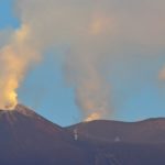
Alaska , Semisopochnoi :
51°55’44 » N 179°35’52 » E,
Summit Elevation 2625 ft (800 m)
Current Volcano Alert Level: WATCH
Current Aviation Color Code: ORANGE
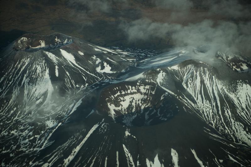
Close-view of the three summits of Mount Cerberus, a large, young, post-caldera vent cluster that dominates the interior of the caldera basin. Semisopochnoi Island, in November 2012. Photograph courtesy of Roger Clifford.
A low-level eruption involving both steam and magma continues at Semisopochnoi. Seismic activity at Semisopochnoi has been elevated with unsteady tremor and low-frequency earthquakes over the past day. Ground-coupled airwaves, indicative of explosive activity, have been seen at times in seismic data. Infrasound associated with the explosive activity registered during the past 24 hours on an infrasound array located at Adak, approximately 250 km to the east of the volcano. Nothing significant was observed in cloudy satellite images.
Semisopochnoi is monitored with an on-island seismic network and remotely by satellite and lightning sensors. An infrasound array on Adak Island may detect explosive emissions from Semisopochnoi with a slight delay (approximately 13 minutes) if atmospheric conditions permit.
Source : AVO.
Photo : Roger Clifford.
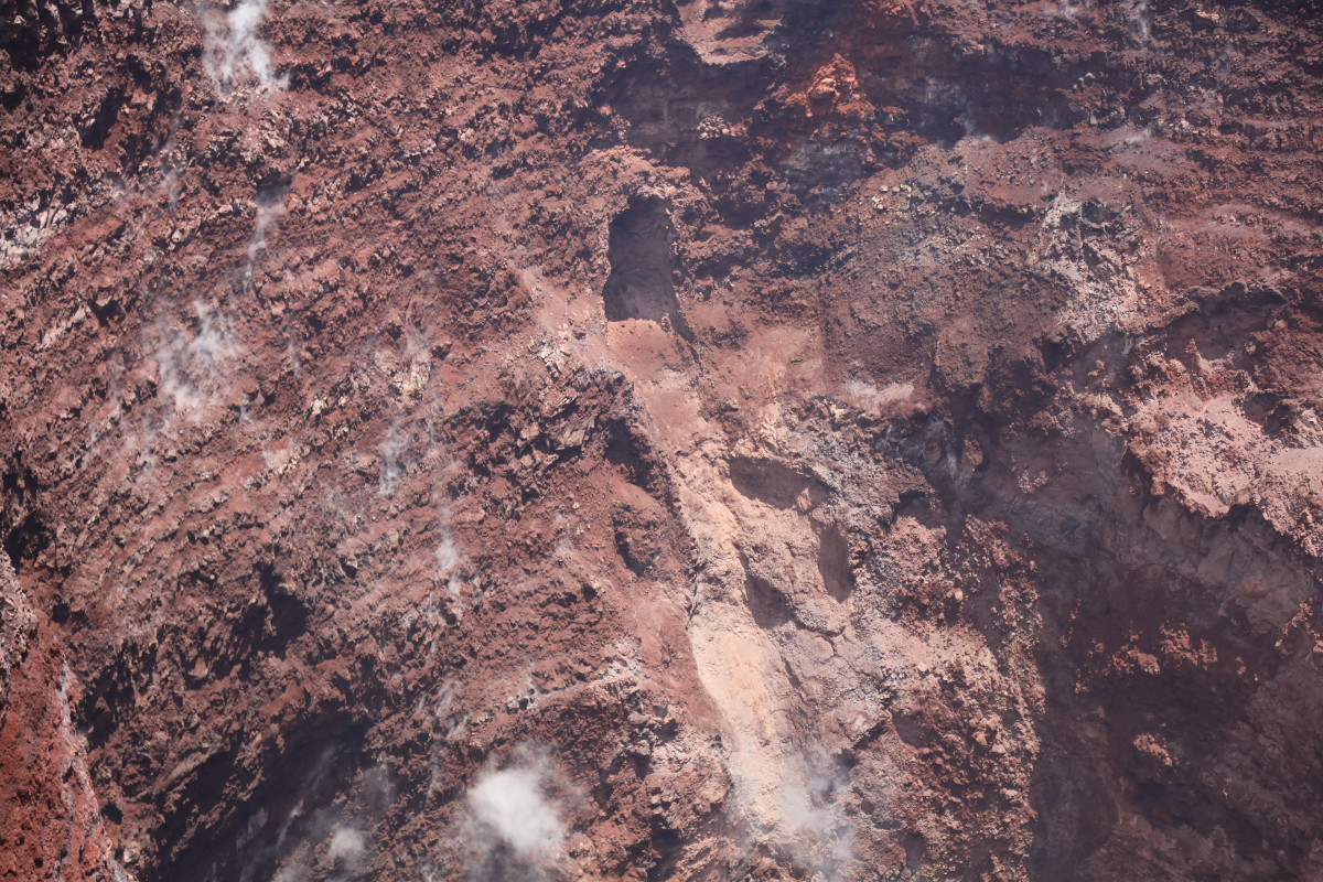
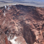
Hawaii , Puʻu Ōʻō :
Puʻu ʻOʻo Overflight Reveals Hole In Crater Wall.
During a recent overflight of the quiet Puʻu Ōʻō vent on Kīlauea Volcano’s East Rift Zone, the USGS Hawaiian Volcano Observatory got a good view of the drained crater, where a 35 year-long eruption came to an end last year.
“Rubble from crater wall collapses has filled in much of the deeper part of the crater, with the bottom now at about 250 meters (820 feet) below the east rim,” the scientists noted. They also noticed something new on the eastern wall of the crater: an exposed hole.
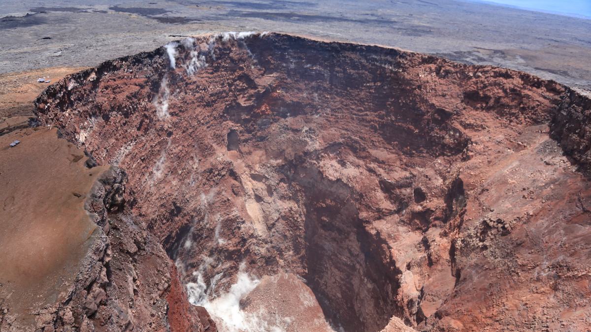
“It is unclear if this is simply a rockfall or collapse feature with a debris slope or if it is part of the conduit that fed episode 61 activity,” the USGS HVO wrote about the hole.
Those familiar wth the eruptive activity of Puʻu Ōʻō will remeber the 61 activity as the eruptive phase that followed the June 27 flow that threatened Pāhoa, and ended with a dramatic collapse that signalled the start of the destructive events in that devastated Leilani Estates and Kapoho on the lower East Rift Zone last year. The 61g event featured an ocean entry , that captivated a world-wide audience.
Kīlauea Volcano is no longer erupting and “monitoring data continue to show steady rates of seismicity and ground deformation, low rates of sulfur dioxide emission, and only minor geologic changes since the end of eruptive activity in September 2018,” scientists say.
Sources : bigislandvideonews.com , USGS.
Photos : USGS/ C. Parcheta , 22 / 08 / 2019.
Mexico , Popocatepetl :
August 24, 11:00 am (August 24, 4:00 pm GMT)
In the last 24 hours, thanks to the monitoring systems of the Popocatepetl volcano, 203 exhalations have been identified, accompanied by water vapor, gas and small amounts of ash dispersed to the North-North-West. In addition, 18 explosions were recorded, including 12 yesterday (23) and seven today (24). However, due to the high cloudiness in the volcano area, visibility was partial. Similarly, 167 minutes of low amplitude tremor were recorded.
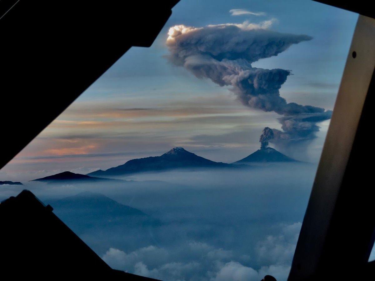
Today in the morning and at the time of this report, we observe the volcano with a gas emission oriented North-Northeast.
CENAPRED urges NOT to approach the volcano and in particular the crater, because of the risk of falling ballistic fragments, and in case of heavy rains, to stay far from the bottom of the ravines because of the risk of mudslides and debris.
The warning light of Popocatépetl is in YELLOW PHASE 2.
Source : Cenapred.
Photo : pilote Jaime del Río , 18/06/2019.
Costa Rica , Rincon de la Vieja :
Daily report of the state of volcanoes. OVSICORI-UNA, Date: 23 Aug 2019, Updated at: 12:45:00 PM.
No eruption is reported.
The seismic activity is greater than that of the previous days.
At the time of this report, the winds are blowing west.
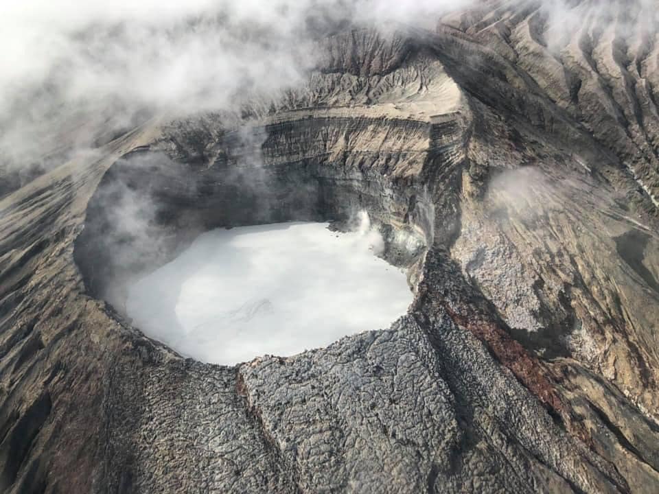
Seismographs record low seismic activity with very sporadic events of low frequency type and long period type LP amplitude associated with the transport of fluids within the volcano. The Ojo de Agua Santuarium geochemical monitoring station located 4 km north of the main crater detected between August 17 and up to now an increase in total temperature of 0.5 degrees Celsius, an increase in the density heat flow from -0.51 to -0.31 watts / m2; a decrease in pH from 3.73 to 3.71 (i.e., an increase in acidity); a reduction in the oxidation-reduction potential (ORP) and an increase in salinity (from 1640 to 1730 us / cm). These changes in the Ojo de Agua Santuarium could reflect an increase in the flow of the Rincón hydrothermal magma system due to the hydraulic pressure exerted by the rainwater when they infiltrate the subsoil and increase the pore pressure.
Source : Ovsicori.
Photo : Chris Allen.


No comment yet, add your voice below!