August 16 , 2019.
La Réunion , Piton de la Fournaise :
Activity Bulletin from Thursday, August 15, 2019 to 14:00 (local time).
Alert level: Alert 2-2.
After a break of about 4h10, the eruption started on 11/08/2019 at 16:20 local time, resumed today, the 15/8/2019 at 8:30 (Figures 1 and 2).
The eruptive activity is always at the level of the 2nd crack opened on 11/08/2019 at 1500 m altitude.
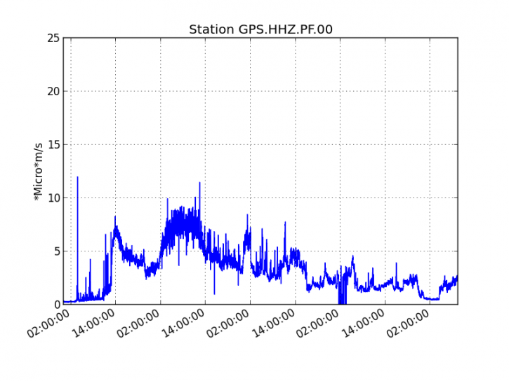
Figure 1: Evolution of the RSAM (indicator of the volcanic tremor and the intensity of the eruption) between 04:00 (00:00 UT) on August 11 and 13:30 (9:30 UTC) on August 15, 2019 on the GPS seismic station, the most close to the eruptive site (© OVPF-IPGP).
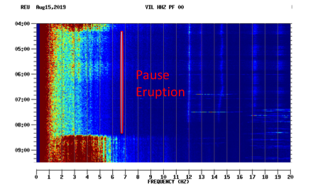
Figure 2: Spectrogram of the VIL seismic station, located on the southern wall of Enclos Fouqué, illustrating the break in eruptive activity between 04.20 and 08.30 local time on 15 August 2019 (© OVPF-IPGP).
Last night the eruptive activity focused on two main eruptive mouths that formed on the crack n ° 2 opened on 11/08/2019 (Figure 3). Numerous outlets descended on the first 500 m before settling (Figures 4 and 5). The front of the main channel showed no progression for 48 hours and was still between 600 and 650 m above sea level. 2 km from the national road 2
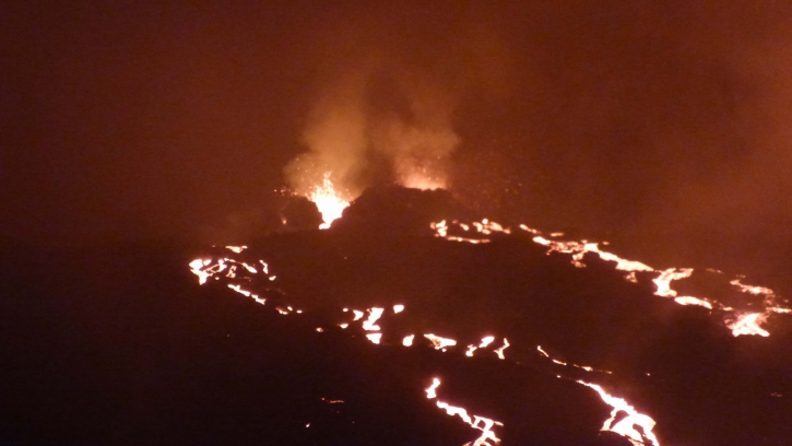
Figure 3: Photograph of the eruptive site on August 14th at 21h local time (© OVPF-IPGP)
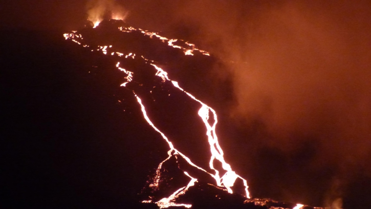
Figure 4: Shooting of the eruptive site on August 14 at 21h local time (© OVPF-IPGP)
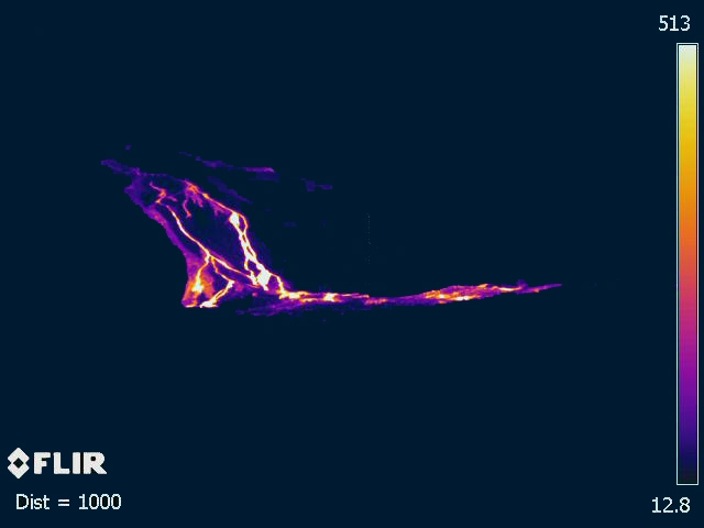
Figure 5: Thermal imaging of the flows down the Great Slopes August 14 at 21h local time (© OVPF-IPGP).
On the day of yesterday, August 14th, 18 volcano-tectonic earthquakes were recorded under the summit zone and under the south-east flank.
Due to the low flows and the cloud cover at the level of eruptive mouths, no flow measurement by the satellite data could be estimated since the resumption of activity this morning at 8:30.
Activity Bulletin from Friday, August 16, 2019 at 07:00 (local time).
Alert level: Alert 2-2
The eruption started on 11/08/2019 at 16:20 local time stopped again on 15/08/2019 at around 22:00 local time, after a little over 6 hours of activity of « gas piston » or « puffs » of tremor.
The eruptive activity on the surface is currently stopped, only persistent degassing at the level of eruptive fissures and glare at the lava flows that are being cooled.
No hypothesis is discarded as to the evolution of the future situation (permanent shutdown, resumption of activity on the same site, resumption of activity elsewhere), a seismicity still being recorded under the summit of the volcano.
Source : OVPF.
Lire l’article : http://www.ipgp.fr/fr/ovpf/bulletin-dactivite-jeudi-15-aout-2019-a-14h00-heure-locale
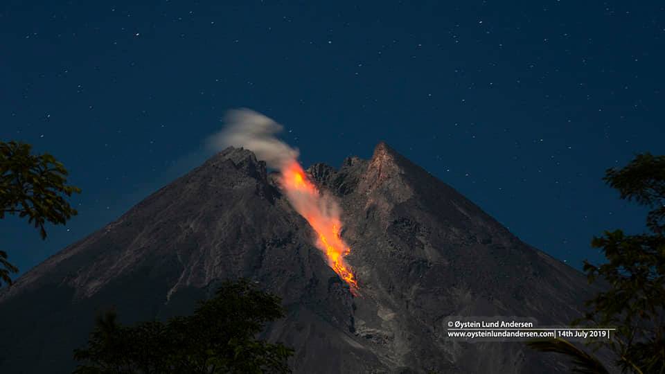
Indonesia , Merapi :
7.54°S, 110.446°E
Elevation 2910 m
PVMBG reported that during 5-11 August the lava-dome volume at Merapi had decreased compared to the week before and was an estimated 461,000 cubic meters, based on analyses of drone images. Extruded lava fell into the upper parts of the SE-flank, generating a total of two block-and-ash flows that traveled as far as 1.2 km down the Gendol drainage on 4 and 6 August. Diffuse white plumes rose as high as 50 m above the summit on some days. The Alert Level remained at 2 (on a scale of 1-4), and residents were warned to stay outside of the 3-km exclusion zone.
In one week, there were 5 episodes of hot avalanche clouds with a maximum slip distance of 1,200 meters leading upstream of Kali Gendol.
Seismicity:
During this week, the seismicity of Mount Merapi recorded:
5 hot avalanche earthquake (AP),
6 earthquake emission (DG),
3 shallow volcanic earthquakes (VTB),
14 multiphase volcanic earthquakes (MPs),
156 avalanche earthquake (RF),
4 low frequency earthquakes 4 times (LF)
18 tectonic earthquakes (TT).
This week’s RF seismicity is higher than last week’s seismicity.
Deformation
The deformation of G. Merapi, monitored by EDM and GPS this week, showed no significant change.
Rain and lahars
This week, no rain or lahars were reported, nor was there an increase of flows in the rivers flowing from Mount Merapi.
Source : GVP , PVMBG.
Photo : Oystein Lund Andersen
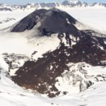
Hawaii , Mauna Loa :
19°28’30 » N 155°36’29 » W,
Summit Elevation 13681 ft (4170 m)
Current Volcano Alert Level: ADVISORY
Current Aviation Color Code: YELLOW
Activity Summary:
Mauna Loa Volcano is not erupting. Over the past week, rates of deformation and seismicity continue to remain slightly elevated.
Observations:
During the past week, approximately 46 small-magnitude earthquakes (all less than M2.0) occurred beneath the summit and upper Southwest Rift Zone. Most of the earthquakes occurred at shallow depths of less than 5 km (~3 miles).

A vertical view of the whole Sulphur Cone area, including a sulphur flow out of one of the cones (yellow bottom of image). The white in the middle of the image is caused by alteration of the rock by volcanic gas.
Global Positioning System (GPS) and Interferometric Synthetic Aperture Radar (InSAR) measurements show continued summit inflation, suggestive of recharge of the volcano’s shallow magma storage system.
No significant changes in volcanic gas release at Sulphur Cone on the Southwest Rift Zone were measured. Fumarole temperatures at both Sulphur Cone and at the summit remain stable.
Updates on the status of Mauna Loa Volcano will be issued each week on Thursdays until further notice.
Source : HVO.
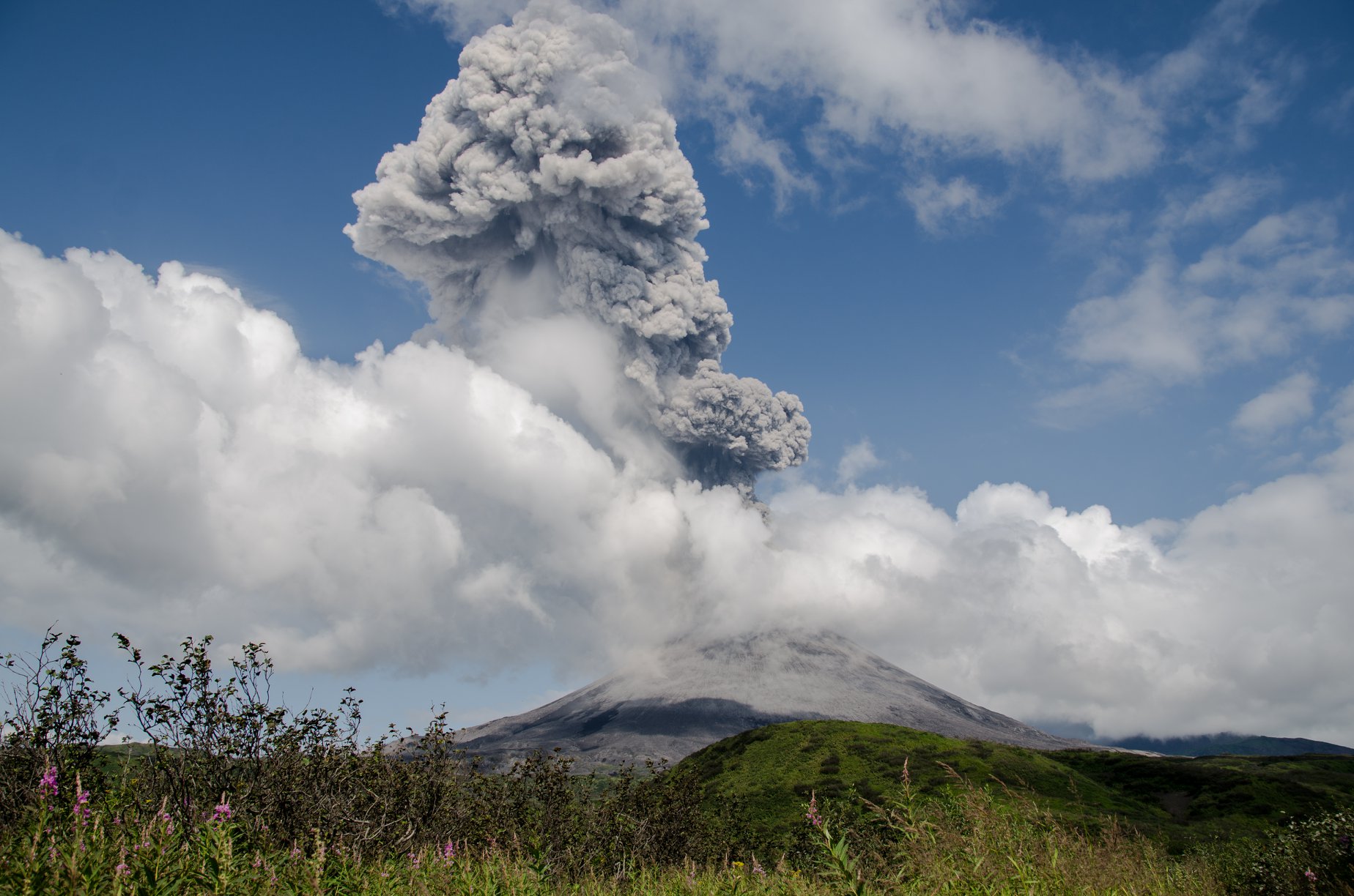
Kamchatka , Karymsky :
54.05 N, 159.44 E;
Elevation 4874 ft (1486 m)
Aviation Colour Code is ORANGE
A moderate eruptive activity of the volcano continues. Ash explosions up to 19,700 ft (6 km) a.s.l. could occur at any time. Ongoing activity could affect low-flying aircraft.

This moderate eruptive activity of the volcano continues. According to visual data by volcanologists which work near the volcano, explosions sent ash up to 5.0 km a.s.l. on 14 August. Satellite data showed a thermal anomaly over the volcano on 11-12 and 15 August; ash clouds drifted to the east and south-southeast from the volcano on 14 August; the volcano was quiet or obscured by clouds during other days of the week.
During the past days, the volcano has been very active, producing frequent explosive eruptions with ash emissions that rose up to 3-5 km above the crater.
Our group on the ongoing expedition to Kamchatka’s volcanoes was lucky enough to observe this activity from close – they stayed 3 days and 3 nights near the volcano along with scientists from the Institute of Volcanology and Seismology of Petropavlovsk.
Irina from our team reported: « On Aug 12 … we flew to Karymsky. The next day everyone went to the volcano. Met a bear, he saw us and left. At that moment, the volcano erupted with a large ash emission, near-continuous puffs of ash lasting into the evening.
The next day, the group went to the lake, and there they also saw a bear, he walked along the shore, but he did not see them. After lunch, then bang, and the volcano produced an eruption column of about 3 km height. This phase lasted 3 hours. …
At night, the volcano erupted again at 4 o’clock and there were beautiful red trajectories and impacts of glowing lava bombs. … Today, the volcano erupted again, with a very large column rising about 5 km, but the top of the ash column was not well visible due to a layer of clouds. The eruption thundered very well and loudly!
Source : Kvert , Volcanodiscovery .
Photos : Dmitry Melnikov.
Lire le reportage : https://www.volcanodiscovery.com/karymsky/news/85304/Karymsky-volcano-Kamchatka-activity-update-and-field-report-explosions-and-strong-ash-emissions.html


No comment yet, add your voice below!