
July 07 , 2019.
Italy / Sicily , Etna :
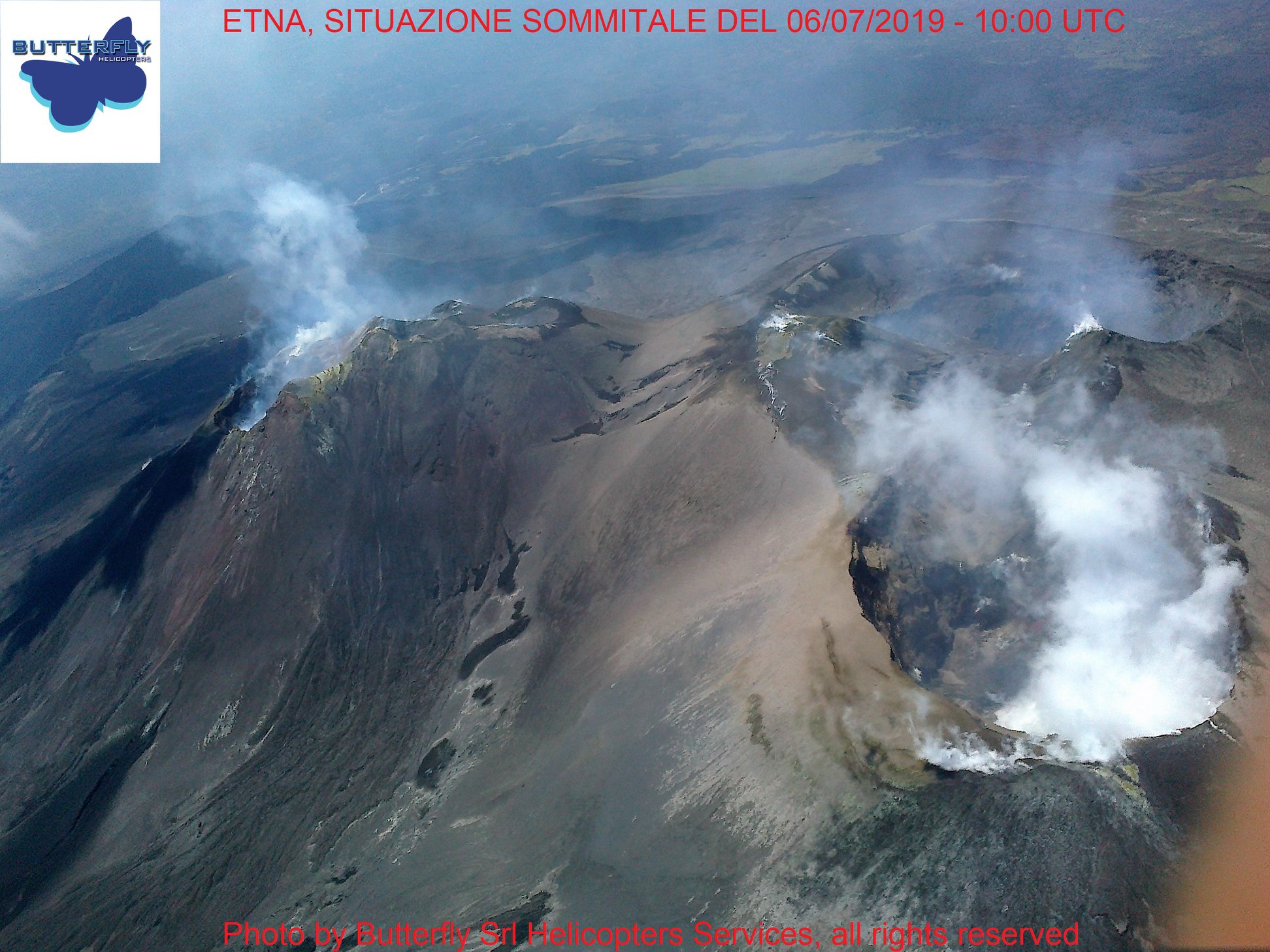
ETNA
COMMUNICATION ON THE VOLCANIC ACTIVITY of July 06, 2019, 08:40:42 (UTC).
The National Institute of Geophysics and Volcanology, Osservatorio Etneo, reports that, thanks to surveillance cameras, discontinuous and light ash emissions are observed from the new crater of the Southeast. Ashes disperse rapidly in the atmosphere near the summit area. In addition, the INGV field staff observed rare highly diluted ash emissions from the Bocca Nuova crater. For the Northeast crater, no other ash emission was observed compared to that reported in Update Notification n. 4 from 03/07/2019 to 10:25 UTC.
The flow of SO2 measured by the FLAME network at 08:30 UTC indicated mean-low values and below the attention level of 5,000 t / d.
As for the average amplitude of the volcanic tremor, it remains weak. The infrasound activity is weak, with sources located under the Bocca Nuova.
ETNA
COMMUNICATION ON THE VOLCANIC ACTIVITY of July 06, 2019, 10:43:05 (UTC).
The National Institute of Geophysics and Volcanology, Osservatorio Etneo, announced that at 10.33 UTC, the average amplitude of volcanic tremor had increased. The INGV field staff observes Strombolian activity from the new crater in the Southeast with projections falling on the sides of the crater.
ETNA
COMMUNICATION ON THE VOLCANIC ACTIVITY of July 06, 2019, 12:50:00 (UTC).
The National Institute of Geophysics and Volcanology, Osservatorio Etneo, announced that at 12:50 UTC, the average amplitude of volcanic tremor decreased sharply, to recover its values prior to the increase indicated in the update not. 6. According to the surveillance cameras and according to the information provided by the INGV staff, the Strombolian activity of the new crater of the South-East also stopped on the ground, producing only very few and very low, highly diluted ash emissions that disperse rapidly in the summit region. In addition, the flow of SO2 measured by the FLAME network at 14:00 UTC remains at an average daily value of about 2,000 t / d, below the attention level of 5,000 t / d.
Source : INGV VULCANI.
Video : INGV.
Photo : Joseph Nasi , butterfly helicopter.
Indonesia , Anak Krakatau :
Level of activity at level II (Waspada), since March 25, 2019. G. Anak Krakatau (157 m altitude) has increased its volcanic activity since June 18, 2018, which was followed by eruptions in September 2018 to June 2019. In July 2019, eruptions occur but of decreasing intensity.
Since yesterday and until this morning, the volcano was covered with fog. The smoke from the crater is not observed. The wind is blowing weakly to the northeast, southwest and west.
The seismographs, on July 5, 2019, recorded:
1 earthquake emission
Continuous Tremor amplitude 2 – 10 mm, dominant value of 2 mm
Recommendation: People / tourists are not allowed to approach the crater within 2 km.
VOLCANO OBSERVATORY NOTICE FOR AVIATION – VONA.
Issued: July 03 ,2019
Volcano: Anak Krakatau (262000)
Current Aviation Colour Code: ORANGE
Previous Aviation Colour Code: orange
Source: Anak Krakatau Volcano Observatory
Notice Number: 2019KRA126
Volcano Location: S 06 deg 06 min 07 sec E 105 deg 25 min 23 sec
Area: Lampung, Indonesia
Summit Elevation: 502 FT (157 M)
Volcanic Activity Summary:
Eruption with ash clouds at 00:09 UTC (07:09 local time). The eruption lasted for 38 seconds.
Volcanic Cloud Height:
Ash-cloud is not visible
Other Volcanic Cloud Information:
Anak Krakatau volcano is not clear.
Remarks:
Eruption recorded on seismogram with maximum amplitude 42 mm and duration 38 second.
Source : PVMBG , Magma Indonésie.
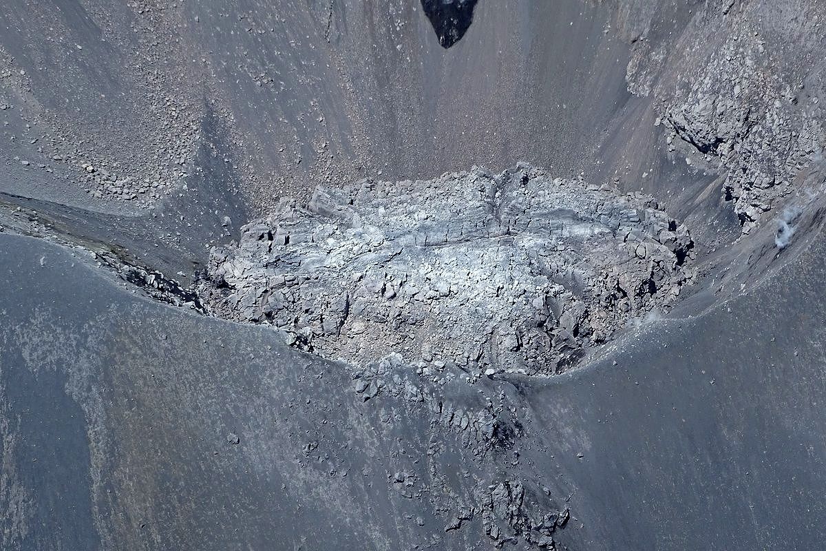
Chile , Nevados de Chillan :
Volcanic Activity Report (RAV), Volcanological Observatory of the South Andes – Ovdas, 06 July 2019 15:00 HL.
Current alert level: ORANGE
Volcanic monitoring.
Seismic activity: During the last 24 hours, the monitoring network of the Nevados volcanic complex in Chillan continues to record long-period seismicity (LP) and tremor episodes, with seismic energy remaining at moderate rank . The seismicity LP and TR being related to the occurrence of explosions which impulses the surface activity and is associated with the variation between the growth and the partial destruction of the viscous lava dome in the crater Nicanor.
Observations:
4 earthquakes type VT were recorded. The highest energy event was located 1 km east-northeast of the active crater at a depth of 2.4 km.
Other observations:
When weather conditions were allowed, it was possible to observe on the fixed camera a predominantly white column of gas from the active crater.
Infrasound sensors recorded acoustic signals associated with explosions (EX) with maximum values and less than 0.2 Pa (reduced to 1 km as a reference).
No thermal radiation was reported according to the information processed by the MIROVA group.
Danger:
Exposure / Specific risks:
After one year of observation, the dacitic dome maintains a low growth rate, with values around 0.003 m3 / s. Under these conditions, and if a major explosive event occurs, global statistics indicate that in 64% of cases it will be associated with a moderate to low explosive explosion (IEV = 0 to 2).
On the other hand, since the appearance of the dome in December 2017, there have been sporadic explosions with energy levels above the average of the current eruptive cycle. The area impact of this is limited to a radius that is not greater than 1 km around the active crater.
…/…
Read the full report: http://sitiohistorico.sernageomin.cl/reportesVolcanes/20190706065815456RAV_Ñuble_Julio_2019_Nº187.pdf
Source : Sernageomin .
Photo : Sernageomin , juin 2018.
United States, Coso Volcanic Field :
CALIFORNIA VOLCANO OBSERVATORY INFORMATION STATEMENT , U.S. Geological Survey
Saturday, July 6, 2019, 10:42 AM PDT (Saturday, July 6, 2019, 17:42 UTC)
COSO VOLCANIC FIELD VOLCANO (VNUM #323180)
36°1’48 » N 117°49’12 » W,
Summit Elevation 7874 ft (2400 m)
Current Volcano Alert Level: NORMAL
Current Aviation Color Code: GREEN
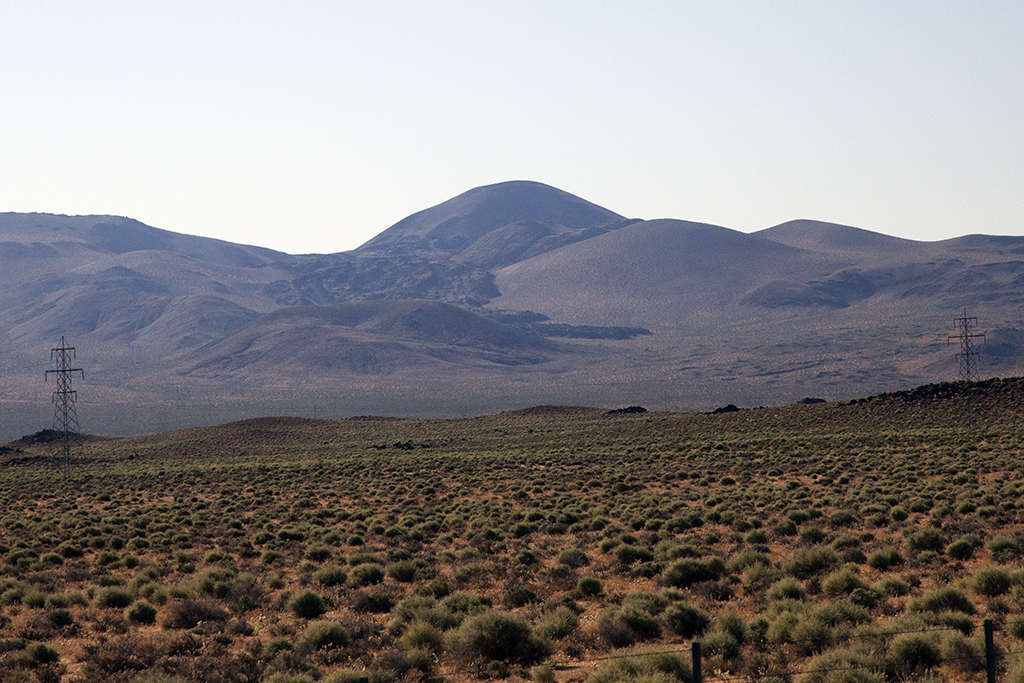
An earthquake swarm started on the evening of July 5 at the southern margin of Coso Volcanic Field in Inyo County, California. The swarm activity was triggered by a magnitude M5.4 earthquake at 9:19 PM PDT located 20 km (~20 miles) ESE of Little Lake, which itself was likely an aftershock of the M7.1 earthquake that occurred about an hour earlier 17 km NNE of Ridgecrest, and south of the Coso area. An average of about 30 earthquakes per hour have been detected since, most within the range of magnitude M1 to M3. No ground deformation indicative of volcanic activity has been detected, and there is no imminent threat of an eruption. The California Volcano Observatory will continue to monitor the situation for any sign of volcanic activity and provide updates as warranted.
The Coso Volcanic Field is located on the eastern side of the Sierra Nevada mountains at the northern end of the Mojave Desert, about 64 km (~40 miles) north of Ridgecrest. The field covers about 150 square miles primarily within the Naval Air Weapons Station at China Lake, and is comprised of lava domes, lava flows, and cinder cones erupted over the past 250,000 years. The most recent eruption was about 40,000 years ago.
Source : Calvo.
Photo : DonCrain.
Mexico , Popocatepetl :
July 06, 11:00 am (July 06, 16:00 GMT).
In the last 24 hours, thanks to the monitoring systems of the Popocatépetl volcano, 891 minutes of tremors have been identified. They were accompanied by a continuous emission of water vapor, gas and small amounts of ash. This episode ended at 3:40 today. In addition, 9 exhalations were recorded.

From this morning until the moment of this report, a constant emission of water vapor and gas is observed, all emissions will be dispersed in a west-north-west direction.
The monitoring system of the Popocatepetl volcano operates 24 hours a day. CENAPRED closely monitors any event. Any changes to the monitoring parameters will be reported promptly.
CENAPRED urges NOT to APPROACH the volcano and especially the crater, because of the risk of falling ballistic fragments, and in case of heavy rains, to move away from the bottom of the ravines because of the risk of mudslide and debris.
The Popocatepetl warning light is located at YELLOW PHASE 2.
Source : Cenapred .
Photo : GL / volcan Popocatepetl FDB.


No comment yet, add your voice below!