
July 05 , 2019.
Italy , Stromboli :
Stromboli eruption. Special press release of July 4, 2019, 09:00 UTC time – 11:00 local time
Update on the current phenomenon.
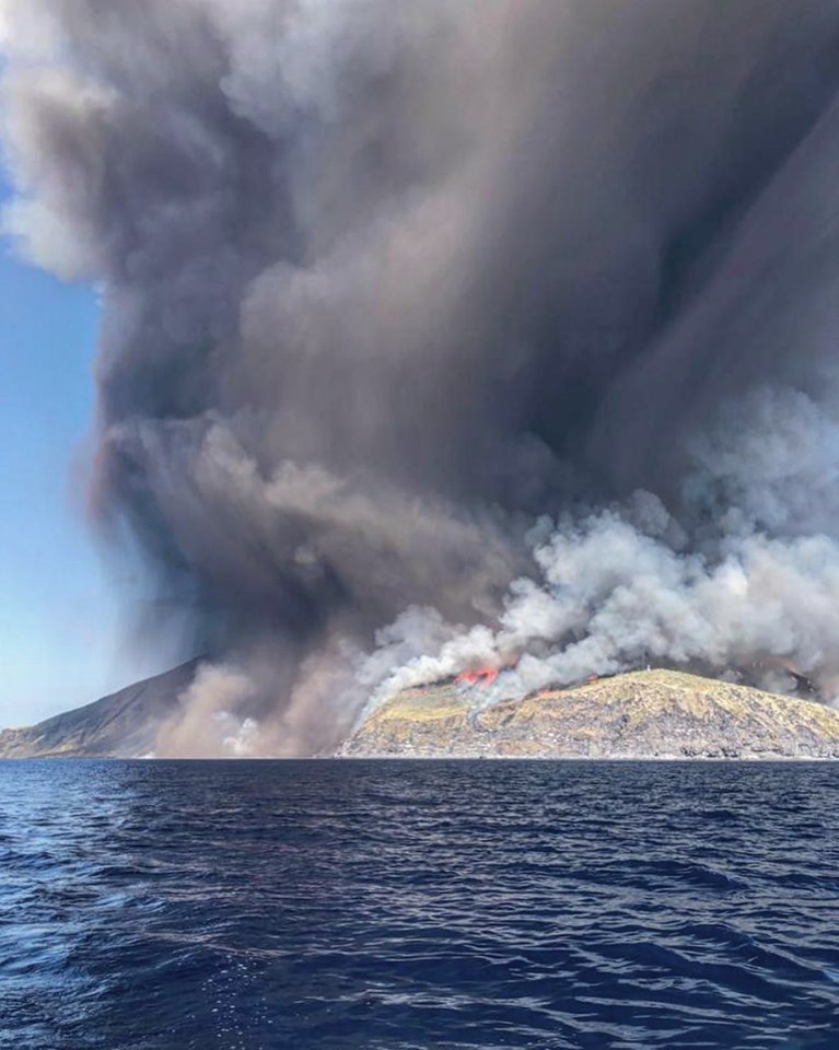
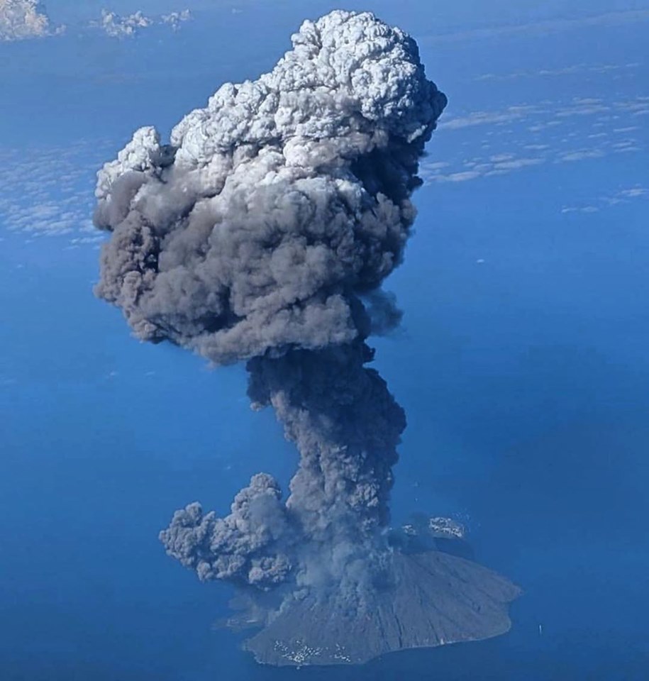
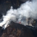
As of 14:46 UTC (all times are in UTC) on July 3, 2019, a paroxysmal sequence occurred that affected the Stromboli crater terrace. The beginning of the phenomenon was preceded by an intensification of Strombolian activity from an active eruptive vent in the central-south zone (S2) and two in the northern zone (N1 and N2), as well as by splashing from two mouths located in the central-south zone (S1 and C). At 13:59, an explosion in the south-central zone also generates an overflow of lava that spreads over the upper part of the Sciara del Fuoco. Starting at 2:43:10, the lava overflow starts from all the active mouths inside the crater terrace; especially at 14:43:10 from mouth C, at 14:44:20 UTC from both mouths N1 and N2, at 14:45:00 the overflow starts from mouth S2.
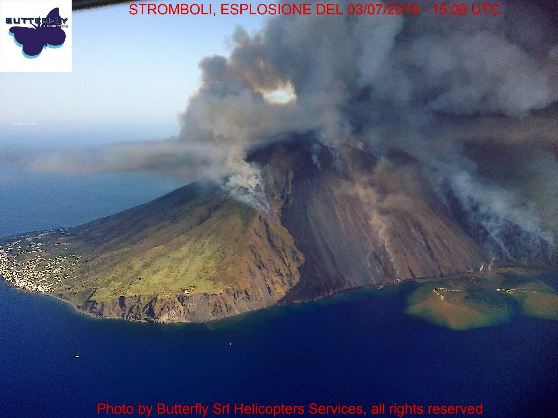
At 14:45:50 UTC, there was a more intense explosion of the N1 vent with lava flow. The paroxysmal phase begins at 14h46h from the south-central crater zone, followed by two lateral explosions at 14h46:10 and 14h46:20 respectively, presumably from the central-south zone of the crater terrace. At 14 h 46 min 40 s, the main paroxysmal explosion affecting the entire crater terrace was recorded. This feeds an overflow of lava that takes place on the Sciara del Fuoco, whose breccia front generates the rolling of incandescent blocks that reach the coast. INGV field staff observed an eruption column about 4 km above the summit area. The products generated by the paroxysm and the collapse of the main eruptive column and the two lateral detonations fell along the flanks of the volcano, generating at least two highly turbulent pyroclastic flows that descended along the Sciara del Fuoco, arriving at sea . At 14 h 59 min 40 s, Strombolian activity resumed, with explosions more intense than those usually observed and the cooling of the relapsed products. The overflow of lava remained, which formed at least two lava flows.
Today, July 4, 2019, splashes are recorded in the south-central zone and an overflow of active lava generating four active flows is spreading in the southern sector of the Sciara del Fuoco reaching the coast.
Historical activity framework.
Stromboli’s ordinary activity consists of strombolian explosions that occur at an average frequency of 10 to 20 minutes from the mouths of the summit. This typical activity of varying intensity is sometimes interrupted by more energetic or paroxysmal explosions. The latter are discrete and violent events that generate eruptive columns that rise for several kilometers above the vents with coarse material fallout that can even reach the inhabited centers of the island and form from time to time pyroclastic flows and lava flows along the slopes of the volcano.
The most powerful explosions can launch bombs and multidimensional blocks in the area of the summit (Pizzo sopra la Fossa). During the strongest paroxysms, the fallout from incandescent pyroclastic materials can cause fires in vegetation on the upper slopes of the volcano. Among the strongest paroxysms, documented over the last hundred years, are those of 1919, 1930, 2003 and 2007, whose eruption column, that of 1930, generated pyroclastic flows.
Geophysical data:
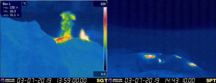
The paroxysmal sequence was visible on the seismic plot which, in addition to the major explosions, revealed about 20 minor explosive events. Today, the magnitude of volcanic tremors remains high.
Inclinometric Network:
After the variations recorded between 14:45 and 14:49 UTC, in the hours that followed, the stations of the clinometric network (Punta Labronzo and Timpone del Fuoco) did not show any significant changes.
Deformations of the soil:
The GPS network of Stromboli, for the moment, does not present any significant variations. However, it should be noted that during the paroxysmal explosion phase, the high frequency processing system measured large variations due to the GPS frequency disturbances induced by the abundant amounts of ash or low frequency deformations. One of the GPS stations (STDF – Timpone del Fuoco, Ginostra), a few minutes after the explosive sequence, stopped working. Further details are underway regarding the data and causes of the STDF station failure.
…/…
Hazard assessment:
Persistent Strombolian type activity of medium-high intensity (explosions greater than 150 m high) and frequency of mid-high events (greater than 20 events per hour) and discontinuous splashing activity in the region central south with lava spilling into the Sciara del Fuoco. Explosions of a higher intensity than ordinary and related phenomena can, however, occur.
N.B. Any modification of the monitored parameters may lead to a different evolution of the event scenarios described above. It is emphasized that the intrinsic and particular characteristics of certain phenomenologies, typical of a volcano in a state of frequent activity and often in a state of persistent imbalance, such as Stromboli, can occur without warning or evolve unexpectedly and rapidly, consequently resulting in a level of danger never zero.
Source : INGV Vulcani
Photos : butterflysrl helicopter services via Marco Neri, Stromboli Adventures , eolianodoc .
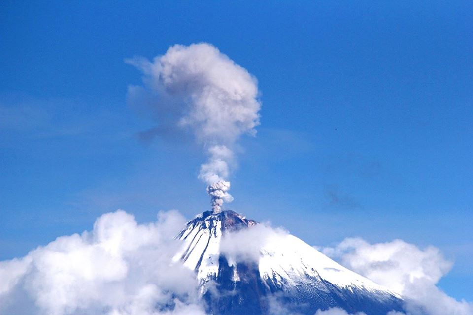
Ecuador , Sangay :
Special Report on the Sangay Volcano N ° 4 – 2019.
Update of eruptive activity
Summary.
The Sangay volcano, in the Morona Santiago province, is continuing its new eruptive phase that began on May 7 until the publication of this report (57 days). The activity is highlighted from two eruptive centers, the central crater and the Ñuñurcu dome (South-East). The central crater has explosive activity and produces small ash clouds less than 2 km above the crater, facing west and southwest. It emits blocks and deposits pyroclastic materials on the flanks. The Ñuñurcu dome exhibits effusive activity associated with the emission of lava flows which are then deposited along the South-East flank. Collapses of the front of these flows also occur during their progression, causing the fall of blocks and small pyroclastic flows (hot avalanches of gases, ashes and blocks).
So far, no ash falls in surrounding populated areas have been reported. However, it has been reported that pyroclastic materials enter the Upano River through its tributary, the Volcán River, which flows down from Sangay. This worried the population living near the banks of the Upano River.
Visual observations and surface activity:
Visual observations related to the eruptive activity of the Sangay volcano have recently occurred due to the presence of sediments, apparently of volcanic origin in the Upano River. As reported in Special Report # 1 on the Sangay Volcano, the pyroclastic materials generated during this eruptive period continued to accumulate on the flanks of the volcano. However, reports have been received from Macas in recent days, indicating high turbidity in the waters of the Upano River (Fig.1.B). Based on observations reported by Sangay National Park technical staff, it has been reported that in the Upano-Volcán River Convergence Zone (Fig.1.A), the presence of abnormal sedimentation, possibly ash or volcanic, could be observed, from the Sangay, and that there was also observed the presence of steam in the water, probably because of the presence of hot blocks from the volcano. (Figure 1.C).
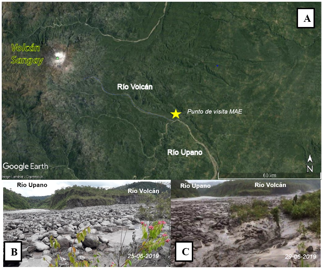
Figure 1. A. Map showing the geographical position of the Sangay volcano in relation to the Volcan and Upano rivers (Google Earth base). B and C. The confluence point between the Volcan and Upano rivers (left margin), where it is possible to notice the presence of turbid water due to the presence of pyroclastic materials in the river. Photographs: courtesy of the Ministry of the Environment (MOE) of Morona Santiago.
As reported in Special Report No. 3, the two eruptive centers, the central crater and the Ñuñurco dome, continue to exhibit different behavior and simultaneous activity so that the pyroclastic material deposited on the flanks can be mobilized by the rains. to drainages up the Volcán River and continuing downstream from it.
The surface activity of the Sangay volcano is evaluated on the basis of satellite image analyzes, images provided by Macas ECU911 and the Morona Santiago MAE, as well as thermal and digital image sequences obtained during the last overview by the staff of the IG-IG. EPN May 17th.
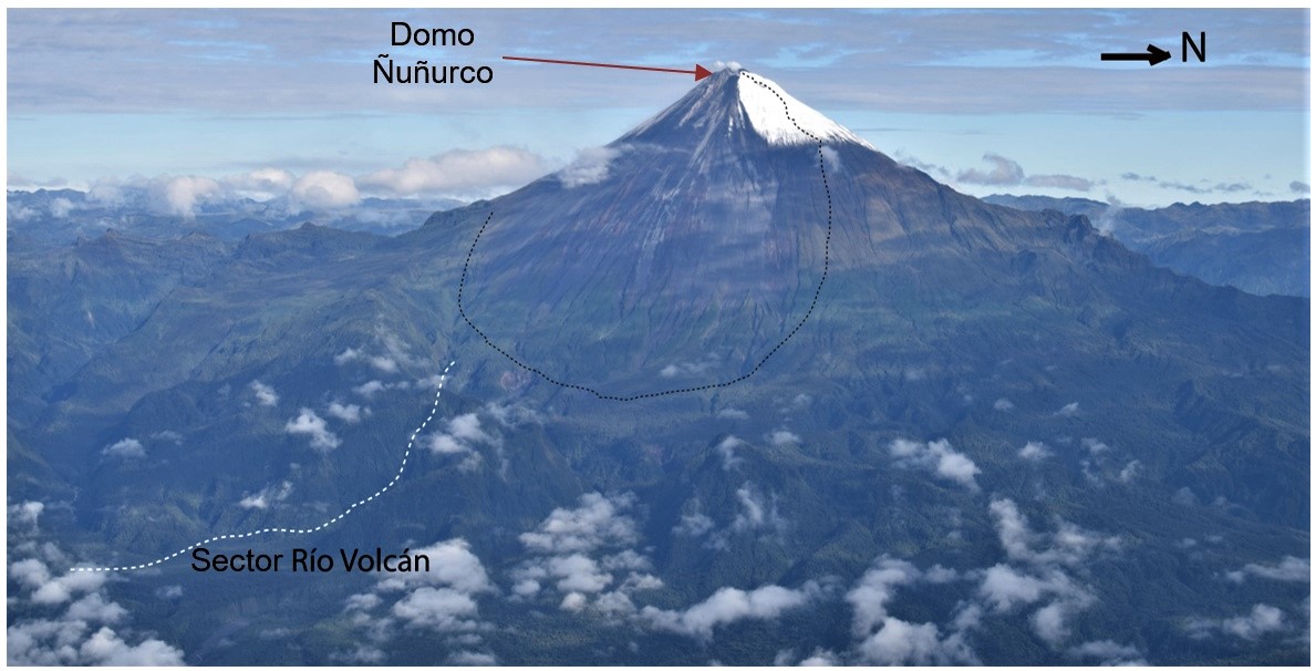
Figure 2. View of the east and southeast flanks of the Sangay volcano during the volcanic surveillance flight on May 17, 2019. Photograph: M Almeida, IG-EPN. The black dashed zone corresponds to the main pyroclastic material deposition zone around the Ñuñurco dome; and the white dotted area corresponds to the Volcan River area.
1. Central Crater:
Its activity is characterized by sporadic explosions projecting ballistic projectiles (incandescent rocks with parabolic trajectories) at a speed higher than 400 km / h. These projectiles fall on the flanks of the cone and on the southeast flank, and roll about 3 km (Fig. 2). The ash columns associated with these explosions reach variable heights between 500 and 1100 m above the crater (660 m snc on average) and their dispersion by the wind is mainly directed towards the West and the South-West.
During the current eruption period, in the volcanic gas emissions detected by the Aura, Suomi and Sentinel 5P satellites (the latter with its TROPOMI instrument), the masses of SO2 were calculated over several minutes (time of acquisition of the satellite). For these emissions, masses between 193 and 310 tonnes of SO2 were estimated between 4 and 105 minutes (during the months of May and June).
2. Domos Ñuñurcu:
The Ñuñurcu dome is located about 190 m south-south-east of the central crater (Fig. 2). Its activity is mainly characterized by the emission of lava flows, which showed emission rates between 0.52 and 4.5 m3 / s (error estimated at about 40%). The collapse of the fronts of these flows also generated small sequential pyroclastic flows and numerous falls of blocks, reaching an altitude of about 3888 m.
Thanks to the analysis of the available images of the Sentinel 2 satellite, the generation of at least three lava flows has been evaluated so far during this eruptive period, by estimating the measurements in advance, the emission rates , surfaces, potential volumes, and geographic distribution, as shown in Fig. 4., using the Sentinel satellite images obtained on May 17, 22 and 27 and June 16 and 26, 2019.
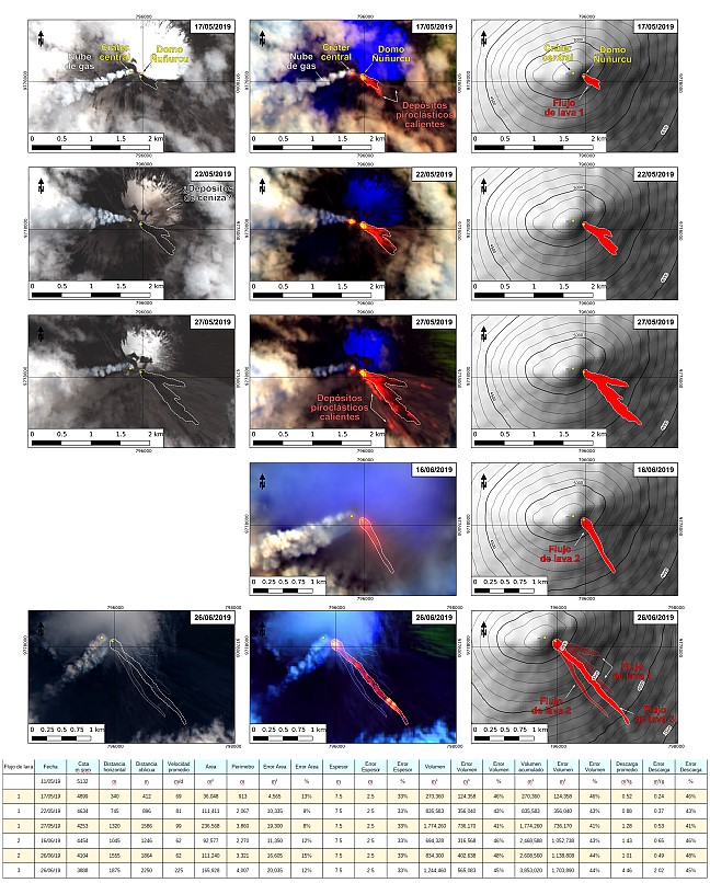
Figure 4. Sentinel-2 images (RGB-B12, B11, B4 bands) and 1: 50,000 scale maps of the Sangay volcano with interpretation of a 30 m terrestrial model (WGS84, Zone 17S) (prepared by: B. Bernard).
Interpretation:
According to the analysis presented, the volcano maintains its explosive activity in the central and effusive crater in the Ñuñurcu dome. This activity is typical of the eruptive phases of the Sangay in recent years. The ash columns reached a maximum height of 1.1 km above the top of the volcano, no ash drop was reported in nearby cities. The main volcanic hazards associated with this activity are the ballistic projectiles and lava frontages that can reach several kilometers.
At present, this behavior of the volcano is maintained, however, it is important to indicate that the volcanic materials coming from this activity would eventually reach the upper tributaries of the Volcán River and that because of the heavy rainfall of the last days, these Materials are being mobilized downstream, being incorporated into the Upano River, which would explain the presence of volcanic sediments in it, as reported in previous days.
Finally, a more complete forecast can not be made due to the lack of geophysical data and an increase in activity in the future can not be ruled out.
Source : IGEPN
Philippines , Taal :
TAAL VOLCANO BULLETIN 05 July 2019 8:00 A.M.
Taal Volcano’s seismic monitoring network recorded twenty-one (21) volcanic earthquakes during the 24-hour observation period. Two of these earthquakes, which occurred at 7:43 AM and 8:10 AM yesterday were felt at Intensity I in Brgy. Calauit, Talisay, Batangas. Field measurements on 4 July 2019 at the eastern sector of the Main Crater Lake yielded no change in water temperature at 34.0°C, an increase in water level from 0.08 meter to 0.10 meter and an increase in acidity from a pH of 2.83 to 2.82. Ground deformation measurements through precise leveling surveys from 15 – 24 June 2019 indicated slight inflation of the edifice consistent with recent results from continuous GPS data.

Alert Level 1 remains in effect over Taal Volcano. This means that hazardous eruption is not imminent. The public, however, is reminded that the Main Crater should be strictly off-limits because sudden steam explosions may occur and high concentrations of toxic gases may accumulate. The northern portion of the Main Crater rim, in the vicinity of Daang Kastila Trail, may also become hazardous when steam emission along existing fissures suddenly increases. Furthermore, the public is also reminded that the entire Volcano Island is a Permanent Danger Zone (PDZ), and permanent settlement in the island is strongly not recommended.
Source : Phivolcs.
Photo : 27 juillet 2013 , Jhong Dizon.
Guatemala , Santiaguito :
SPECIAL VOLCANOLOGICAL BULLETIN, ACTIVITY OF THE SANTIAGUITO VOLCANO, Guatemala City, July 4, 2019, at 4:45 pm (local time).
Activity type: Pelean
Morphology: Complex of dacitic domes
Geographical location: 14 ° 44 ’33 ˝ Latitude N; 91 ° 34’13˝ Longitude O.
Height: 2500msnm.
Following the special bulletin BESAN 45-2019 on the change of activity of the Santiaguito volcano from June 28, 2019 (increase in the number and energy of the explosions), the following update is available:
Since June 28, we are in a new eruption period of Santiaguito volcano, recording more than 40 explosions a day, which are moderate, with the probability of generating strong explosions with abundant ash columns. There is also the possibility of generating more avalanches and pyroclastic flows.
At this time, the activity is maintained in a range of 40 to 45 explosions per day. These are moderate explosions that raise ash columns to 3,800 meters. However, at certain periods, there are 3 to 5 explosions per hour accompanied by strong avalanches that generate small pyroclastic flows on the east and south-east flanks. These reach the base of the Caliente Dome, with the possibility of avalanches with larger pyroclastic flows, so it is not recommended to stay in areas near the Caliente dome.
It should be noted that the composition of the magma of Santiaguito volcano , with high silica content , makes its activity more explosive than the Fuego and Pacaya volcanoes. During the 97 years of Santiaguito’s existence, the main characteristic is the generation of moderate to strong explosions, with ash columns rising more than 5,000 m above the crater, as well as pyroclastic flows due to partial collapse of the dome can reach significant distances, more than 10 km.
Source : Insivumeh
Video : emiaroundtheworld , 29 mai 2016


No comment yet, add your voice below!