
May 13 , 2019.
Chile , Nevados de Chillan :
Special report of volcanic activity (REAV).
Nuble Region, Nevados Volcano of Chillan, 12 May 2019, 20:03 local time (mainland Chile).
The National Geological and Mining Service of Chile (Sernageomin) publishes the following PRELIMINARY information, obtained from monitoring equipment of the National Volcanic Monitoring Network (RNVV), processed and analyzed at the Volcanological Observatory of the Southern Andes (OVDAS) :
Yesterday, Sunday, May 12, 2019 at 20:03 local time (00:03 UTC 13 May), monitoring stations installed near the volcano Nevados de Chillan recorded an explosive event associated with a long-period type of earthquake (Type LP) which was in relationship with fluid dynamics inside the volcano.
The location of the earthquake after its analysis is:
TIME OF ORIGIN: 20h03 Local time (00h03 UTC of 13 May)
LATITUDE: 36.885 ° S
LONGITUDE: 71.379 ° W
DEPTH: 1.5 KM
REDUCED DISPLACEMENT: 564 cm2
OBSERVATIONS:
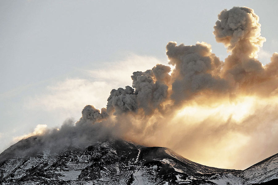
The explosion was associated with the recording of a seismic signal with a reduced displacement value (average of seismic energy) of 564 cm2, considered high. An incandescence associated with the emission of gases and pyroclastic materials at high temperature, which were deposited on the surroundings of the active crater, was also observed. Previous observations suggest a partial destruction of the dome inside the crater. This event is in phase with the current alert level. At the time of this report, no other abnormal signals have been recorded.
The level of volcanic technical alert remains at the level: ORANGE.
Sernageomin continues online monitoring and will inform in a timely manner about any changes observed.
Source : Sernageomin.
Photo : Auteur inconnu , Aout 2018.
Indonesia , Sinabung :
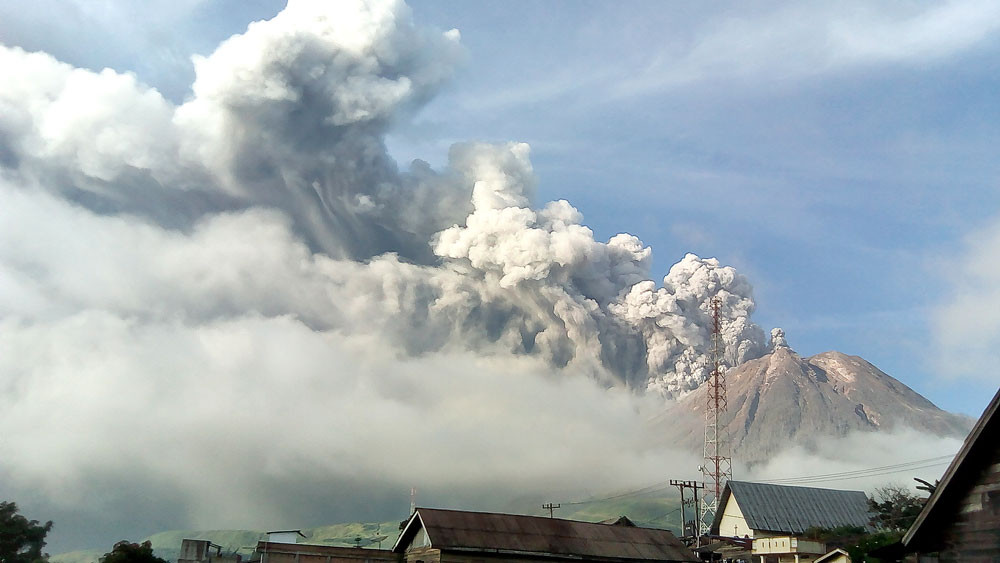
Sinabung’s lava dome grows after third eruption in a week
The Center for Volcanology and Geological Hazard Mitigation (PVMBG) says Sinabung’s lava dome has grown after it erupted for a third time in a week.
Mt. Sinabung, located in Karo regency, North Sumatra, spewed volcanic ash at 12:33 p.m. Sunday after erupting on Saturday evening and last Tuesday.
A Mt. Sinabung monitoring post officer, Armen Putera, said the three eruptions had resulted in the volcano’s lava dome growing.
He said the lava dome was not visible when the volcano initially erupted on Tuesday, but lava had flowed out of the crater for hours on Saturday.
Armen said that during Sunday’s eruption, lava was not visible as it was obscured by fog.
« We estimate that the eruption was not as big as the one five days earlier, » Armen told The Jakarta Post on Sunday.
He said his office had detected quite strong pressure of magma from inside the mountain, as magma started to move to the surface.
He warned that it was an indication that there could be a larger eruption and advised local residents and visitors against entering the danger zone.
Karo Disaster Mitigation Agency (BPDB) head Martin Sitepu said his officers were patrolling the danger zone to warn people against entering.
Sinabung roared back to life in 2010 after being dormant for 400 years. After another period of inactivity, it erupted once more in 2013 and has remained highly active since.
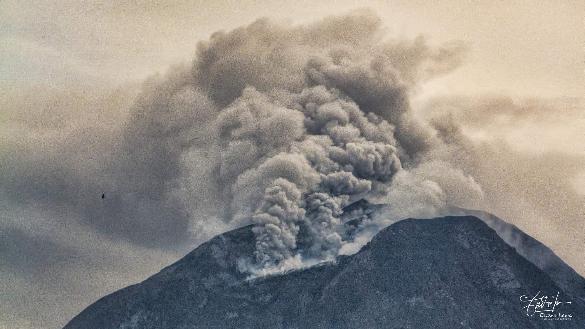
Level of Activity at Level IV (SIAGA). Mount Sinabung (2,460 m above sea level) has erupted since 2013. The last eruption took place on May 12, 2019.
Since yesterday and until this morning, the volcano was clearly visible then covered with fog. The smoke from the crater was white, with low intensity. It was observed about 500 meters above the summit.
Through seismographs on May 12, 2019, it was recorded:
1 eruption earthquake
15 emission earthquakes
1 tremor
15 Low frequency earthquakes
1 distant tectonic earthquake
Tremor continuous with a dominant amplitude of 0.5 mm.
Recommendation:
Persons / visitors must not engage in any activity within 3 km for the Northwest sector, 4 km for the Southwest sector and less than 7 km for the South-Southeast sector within 6 km. for the East-South-East sector and at a distance of 4 km for the North-East sector
Communities along the river below Mount Sinabung should be aware of the potential for lahars descents, especially during heavy rains.
VONA:
An ORANGE color code was published on 12 May 2019 at 12.33 for the last time, with reference to the eruption recorded on a seismogram with a maximum amplitude of 5 mm and the duration of the 1687 earthquake seconds, unnoticed visually.
Source : The Jakarta Post , PVMBG.
Photo : Antara / Sastrawan Ginting 07 Mai 2019 , Endro Lewa , Mai 2018.
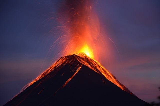
Guatemala , Fuego :
Type of activity: Vulcanian
Morphology: Composite Stratovolcano
Geographical location: 14 ° 28’54˝ Latitude N; 90 ° 52’54˝ Longitude O.
Height: 3,763msnm.
Weather conditions: Clear
Wind: North East at 2 km / h
Precipitation: 36.4 mm
Activity:
Presence of white degassing fumerole at a height of 4400 m altitude, dispersing in the South and Southwest directions. The activity generates 15 to 23 low to moderate explosions per hour, which expels columns of gray ash from a height of 4500 to 4800 m (14764 to 15748 feet) that disperse about 10 to 15 kilometers to the south. and the Southwest. At night and early in the morning, incandescence was observed between 200 and 300 meters above the crater, generating weak and moderate avalanches on the crater contour towards the Seca, Taniluyá, Ceniza, Trinidad and Las Lajas ravines. ‘to the vegetation. Low to moderate rumblings are perceived that give rise to weak shock waves, causing vibrations in the roofs of dwellings, mainly in the communities to the west and southwest. We hear the noise of degassing constantly. Lava flows to the Seca ravine on the west flank for an approximate length of 600 meters. Ash falls are noted in the Panimaché I and II communities, Morelia, Santa Sofia, El Porvenir and other communities in this direction.
Source : Insivumeh
Photo : Nathalie Duverlie , 05/05/2019.
Indonesia , Agung :
VOLCANO OBSERVATORY NOTICE FOR AVIATION – VONA.
Issued: May 12 , 2019
Volcano: Agung (264020)
Current Aviation Colour Code: ORANGE
Previous Aviation Colour Code: orange
Source: Agung Volcano Observatory
Notice Number: 2019AGU22
Volcano Location: S 08 deg 20 min 31 sec E 115 deg 30 min 29 sec
Area: Bali, Indonesia
Summit Elevation: 10054 FT (3142 M)
Volcanic Activity Summary:
Eruption with volcanic ash cloud at 14h29 UTC (22h29 local). Eruption and ash emission is not continuing
Volcanic Cloud Height:
Ash-cloud is not visible
Other Volcanic Cloud Information:
Ash cloud cannot be observed
Remarks:
Seismic activity is characterized by volcanic earthquake
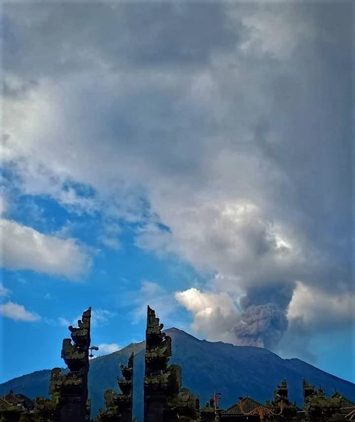
Information on the eruption of G. Agung, May 13, 2019.
An eruption of Mount Agung occurred on May 12, 2019 at 22:29, but the height of the ash column was not observed. This eruption is recorded on a seismogram of maximum amplitude of 25 mm and a duration of ± 2 minutes 16 seconds.
It was heard a dull sound at the Rendang post
Currently, G. Agung is at Activity Level III (SIAGA) with recommendations:
Communities around Mount Agung and mountaineers / visitors / tourists must not climb or carry out any activity in the estimated risk zone within a radius of 4 km around Mount Agung crater. The estimated risk area is dynamic and continues to be evaluated. It can be modified at any time to follow the most recent observation data from G. Agung.
Communities that live and move around rivers that are downstream of Gunung Agung are sensitized to potential secondary hazards in the form of descent of lahars that can occur especially during the rainy season and if eruptive material is still deposited in the area of the summit.
Source : Magma Indonésie , PVMBG.
Photo : Peter rendez vous , Mars 2019.


No comment yet, add your voice below!