
April 19 , 2019.
Mexico , Popocatepetl :
April 18 at 11:00 am (April 18 at 16:00 GMT)
During the last 24 hours, through the monitoring systems of the Popocatepetl volcano, 57 exhalations have been identified and a continuous emission accompanied by water vapor, gas and light amounts of ash that the winds have dispersed preferably towards the East-Southeast sector.
In addition, 103 minutes of low amplitude tremor were recorded.
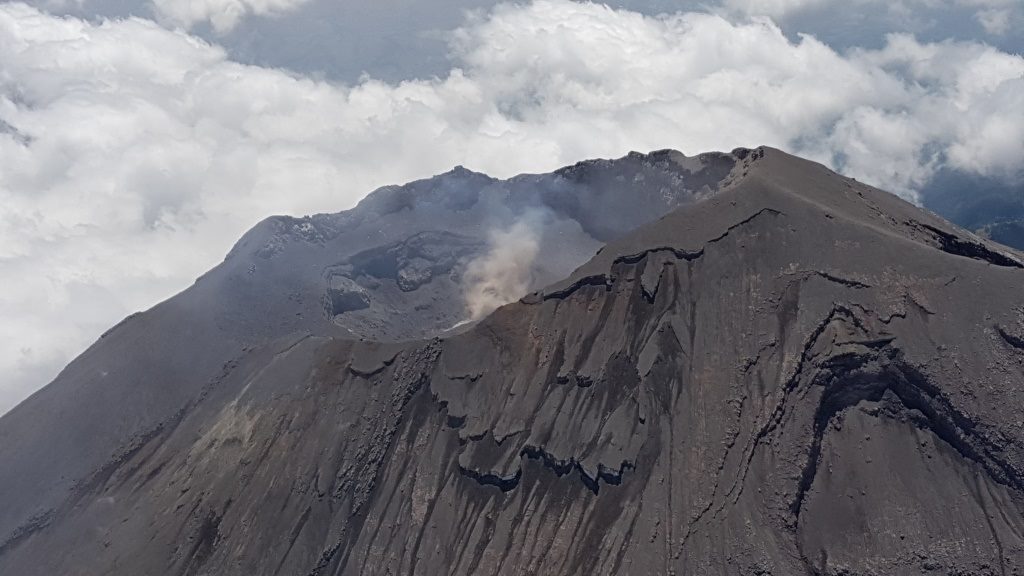
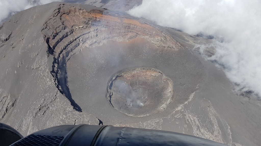
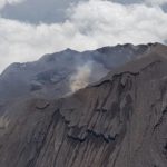
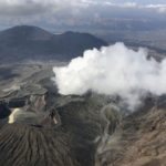
The team of experts who daily monitor the activity of the volcano Popocatépetl unveiled a series of photographs of the crater without dome, which was destroyed at the end of March and has not been reformed, which does not necessarily represent a risk for the population, but behavior change.
The National Prevention Center (Cenapred) announced on March 15 that after the explosions of the 13th and 14th of the same month, the dome 82 had been completely destroyed and the crater had a diameter of 300 meters and a depth of 150 meters, as had said Cenapred Deputy Director of Volcanic Risks, Ramón Espinasa Pereña.
The formation and destruction of domes of the Popocatépetl volcano is a perfectly normal behavior. but a new structure has not been formed for a month.
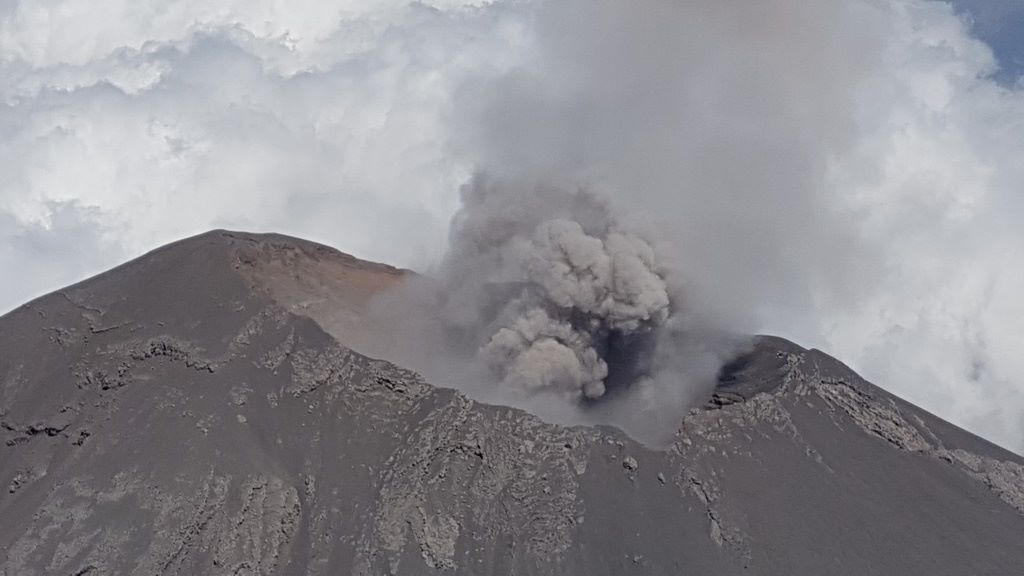
The expert published on Facebook the snapshots of the last flyover conducted in March this year and explained that the presence or absence of a dome does not necessarily mean an increase or decrease in the level of danger of this volcano, because explosions have been recorded. with or without the structure.
« However, when there is a dome, it is important to know its volume, its speed of growth and its location in the crater, to know what volume of lava is needed to fill it, among others, » he added.
In a previous interview with Infobae, the specialist indicated that it had been decided to upgrade to phase 3 yellow alert because of a change in behavior after the destruction of the dome 82.
« In other cases, we had the formation of a clearly identified dome, then the explosions came for its destruction.Every time there is an injection of magma, this magma reaches the surface and forms a body of lava that stays above and blocks all the channels This cooled lava body begins to crystallize and involves increasing gas emissions until the dome explodes, but the explosions we experienced after the 15th March are similar to those produced during the destruction of the dome, but as there are more, there is a doubt, « he said.
The « Popo », located in the limits of the states of Mexico, Morelos and Puebla, continues with a normal activity.
Read the original article: https://www.infobae.com/america/mexico/2019/04/18/volcan-popocatepetl-asi-se-ve-el-crater-del-coloso-desde-el-cielo/?fbclid=IwAR0dMco73THKzmHkr_Xtd469eLiVPKq_3NoVi8Fu9Q21zJfogU7InW-A-rA
Source : Cenapred , infobae.com.
Photos : Ramón Espinasa Pereña
Colombia , Chiles / Cerro Negro :
Weekly activity bulletin Chiles and Cerro Negro volcanoes
The activity level of volcanoes continues at the level: YELLOW LEVEL ■ (III): CHANGES IN THE BEHAVIOR OF THE VOLCANIC ACTIVITY.
Following the activity of the CHILE volcanoes and CERRO NEGRO, the COLOMBIAN GEOLOGICAL SERVICE (SGC) reports that:
For the period from 9 to 15 April 2019, the seismic activity in the Chiles – Cerro Negro volcano region recorded an increase, both in terms of production of events and released energy, from a total of 1328 events the week before. in 1771 events for this week. The majority of registered earthquakes continue to be associated with rock fractures within the volcanic building, with a preferential location south of the Chiles volcano, with epicentral distances of up to 9.5 km, depths less than 12 km below the summit (4700 m) and local magnitudes less than 2.3 on the Richter scale. No events were reported as having been felt.
Other geophysical and geochemical parameters of volcanic monitoring did not show significant variations.
The Colombian Geological Service and the Institute of Geology of the National Polytechnic School of Ecuador are attentive to the evolution of the volcanic phenomenon and will continue to report the changes observed as soon as possible.
Source : SGC.
Photo : Boriss Andean / summit post
Philippines , Taal :
TAAL VOLCANO BULLETIN 19 April 2019 8:00 A.M.
Taal Volcano’s seismic monitoring network recorded seven (7) volcanic earthquakes during the past 24 hours. Field measurements on 18 April 2019 at the western sector of the Main Crater Lake yielded an increase in water temperature from 31.3°C to 32.8°C, a decrease in water level from 0.34 meter to 0.25 meter and increase in acidity from pH 2.85 to pH 2.98. Ground deformation measurements through precise leveling surveys from March 18 to 27, 2019 indicated slight inflation of the edifice consistent with recent results from continuous GPS data.
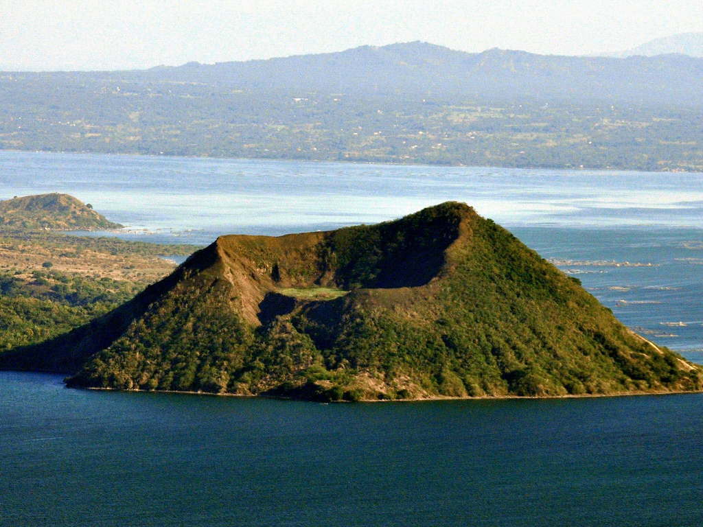
Alert Level 1 remains in effect over Taal Volcano. This means that hazardous eruption is not imminent. The public, however, is reminded that the Main Crater should be strictly off-limits because sudden steam explosions may occur and high concentrations of toxic gases may accumulate. The northern portion of the Main Crater rim, in the vicinity of Daang Kastila Trail, may also become hazardous when steam emission along existing fissures suddenly increases. Furthermore, the public is also reminded that the entire Volcano Island is a Permanent Danger Zone (PDZ), and permanent settlement in the island is strongly not recommended.
Source : Phivolcs.
Photo : Auteur inconnu.
Indonesia , Dukono :
VOLCANO OBSERVATORY NOTICE FOR AVIATION – VONA.
Issued: April 19 20190419/0038Z
Volcano: Dukono (268010)
Current Aviation Colour Code: ORANGE
Previous Aviation Colour Code: orange
Source: Dukono Volcano Observatory
Notice Number: 2019DUK21
Volcano Location: N 01 deg 41 min 35 sec E 127 deg 53 min 38 sec
Area: North Maluku, Indonesia
Summit Elevation: 3933 FT (1229 M)
Volcanic Activity Summary:
Eruption with volcanic ash cloud at 00h17 UTC (09h17 local)
Volcanic Cloud Height:
Best estimate of ash-cloud top is around 5213 FT (1629 M) above sea level, may be higher than what can be observed clearly. Source of height data: ground observer.
Other Volcanic Cloud Information:
Ash cloud moving to east
Remarks:
Eruption and ash emission is continuing
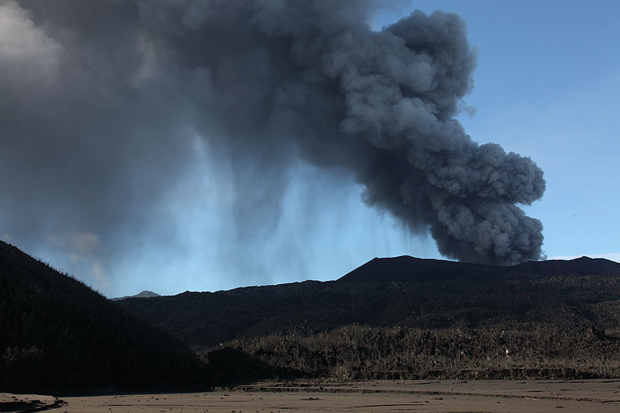
Level II Activity Level (WASPADA). The Dukono (1229 m) has continuous eruptions.
Since yesterday until this morning, the volcano was clearly visible until it was covered with fog. The smoke from the main crater was observed to be white to gray with a thick intensity, rising about 700 meters above the summit.
The seismographs, on April 18, 2019, recorded:
3 earthquakes of eruption
1 volcanic earthquake
1 local tectonic earthquake
5 distant tectonic earthquakes
Tremor continuous with a dominant amplitude of 2 mm
Recommendation: People around G. Dukono and visitors / tourists should not climb or approach the crater of Malupang Warirang within 2 km.
Source : Magma Indonésie , PVMBG .
Photo : Photovolcanica.


No comment yet, add your voice below!