
April 10 , 2019 .
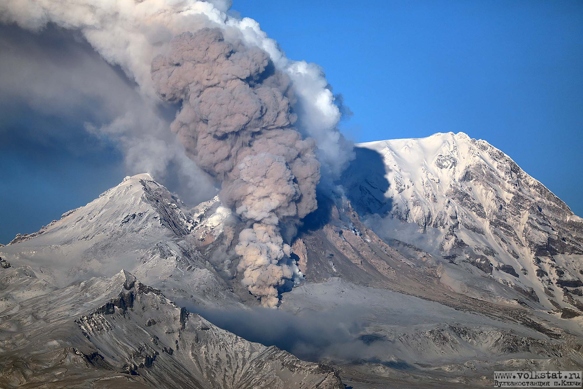
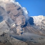
Kamchatka , Sheveluch :
VOLCANO OBSERVATORY NOTICE FOR AVIATION (VONA).
Issued: April 10 ,2019
Volcano:Sheveluch (CAVW #300270)
Current aviation colour code:ORANGE
Previous aviation colour code:orange
Source:KVERT
Notice Number:2019-77
Volcano Location:N 56 deg 38 min E 161 deg 18 min
Area:Kamchatka, Russia
Summit Elevation:10768.24 ft (3283 m), the dome elevation ~8200 ft (2500 m)
Volcanic Activity Summary:
An eruptive activity of the volcano continues. According to video data, explosions sent ash up to 7.5-8 km a.s.l. ash plume began to move to the south-east from the volcano.
Explosive-extrusive eruption of the volcano continues. Ash explosions up to 32,800-49,200 ft (10-15 km) a.s.l. could occur at any time. Ongoing activity could affect international and low-flying aircraft.
Volcanic cloud height:
24600-26240 ft (7500-8000 m) AMSL Time and method of ash plume/cloud height determination: 20190410/0313Z – Video data
Other volcanic cloud information:
Distance of ash plume/cloud of the volcano: 12 mi (20 km)
Direction of drift of ash plume/cloud of the volcano: SE
Source : Kvert
Photo :Volkstat ru ,Yu Demyanchuck , IVS FEB RAS, Kvert.
Chile , Nevados de Chillan :
Nuble Region, Nevados Volcano of Chillan, 09 April 2019, 06:00 local time (mainland Chile).
The National Geological and Mining Service of Chile (Sernageomin) publishes the following PRELIMINARY information, obtained from monitoring equipment of the National Volcanic Monitoring Network (RNVV), processed and analyzed at the Volcanological Observatory of the Southern Andes (OVDAS) :
Yesterday, Tuesday 09 April 2019 at 04h57 local time (08h57 UTC), the monitoring stations installed near the volcano Nevados de Chillan recorded an explosive event with a long period type earthquake (Type LP) which was in relation with the dynamics fluids inside the volcano.

The location of the earthquake after its analysis is:
TIME OF ORIGIN: 04h57 Local time (08h57 UTC)
LATITUDE: 36,866 ° S
LONGITUDE: 71.379 ° W
DEPTH: 1.0 KM
REDUCED DISPLACEMENT: 1376 cm2
OBSERVATIONS:
The explosion was associated with the recording of a seismic signal with a reduced displacement value (average of seismic energy) of 1376 cm2, considered high. An incandescence associated with the emission of gases and pyroclastic materials at high temperature, which were deposited on the surroundings of the active crater, was also observed. Previous observations suggest a partial destruction of the dome inside the crater. This event is in phase with the current alert level. At the time of this report, no other abnormal signals have been recorded.
The level of volcanic technical alert remains at the level: ORANGE.
Sernageomin continues online monitoring and will inform in a timely manner about any changes observed.
Source : Sernageomin.
Photo : Publimetro
Etats – Unis , Yellowstone :
44°25’48 » N 110°40’12 » W,
Summit Elevation 9203 ft (2805 m)
Current Volcano Alert Level: NORMAL
Current Aviation Color Code: GREEN
Recent work and news
There were four water eruptions of Steamboat geyser in March 2019, on March 4, 11, 17, and 25. Discharge measured at the Tantalus stream gage suggests that these eruptions were similar in size to those that occurred earlier in the current sequence (which started in March 2018). Hopefully Steamboat will keep up the action so that more visitors can enjoy the spectacle during the summer of 2019!
Seismicity
During March 2019, the University of Utah Seismograph Stations, responsible for the operation and analysis of the Yellowstone Seismic Network, located 127 earthquakes in the Yellowstone National Park region. The largest event was a minor earthquake of magnitude 3.3 located 14 miles north-northwest of Pahaska Tepee, WY, on March 4 at 10:16 AM MST. The earthquake was not reported felt.
March seismicity in Yellowstone included two swarms of earthquakes. The first swarm of 26 located events occurred 16 miles east-northeast of West Yellowstone, MT, from March 25 to 26 and ranged in magnitude from 0.1 to 1.9. A second smaller swarm of 17 located earthquakes occurred 9 miles west of Old Faithful, WY, on March 28 and ranged in magnitude from 0.1 to 2.0.
Earthquake swarms like these are common and account for roughly 50% of the total seismicity in the Yellowstone region.
Yellowstone earthquake activity remains at background levels.
Ground deformation
There were no significant changes in surface deformation in the Yellowstone area as recorded by GPS stations. Ground subsidence of Yellowstone caldera continues, as it has since 2015, at a rate of a few millimeters per month. In the area of Norris Geyser Basin, GPS data indicate no vertical deformation. That area has shown little net change since October 2018.
The Yellowstone Volcano Observatory (YVO) provides long-term monitoring of volcanic and earthquake activity in the Yellowstone National Park region. Yellowstone is the site of the largest and most diverse collection of natural thermal features in the world and the first National Park. YVO is one of the five USGS Volcano Observatories that monitor volcanoes within the United States for science and public safety.
Source : YVO
Photo : Parc National
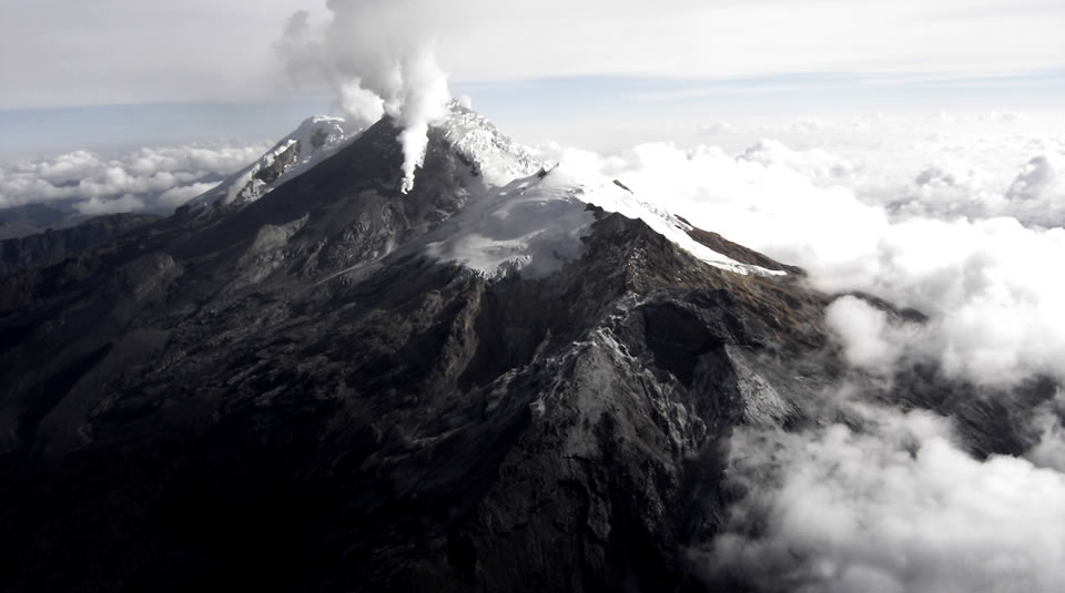
Colombia , Nevado del Huila :
Weekly activity bulletin of the Nevado del Huila volcano:
The level of activity of the volcano continues at the level: yellow activity level or (III): changes in the behavior of volcanic activity.
According to the analysis and evaluation of the information obtained through the surveillance network of the Nevado del Huila volcano, from April 2 to 8, 2019, the COLOMBIAN GEOLOGICAL SERVICE – Volayological and volcanological observatory of Popayán informs that:
During the evaluated period, 570 seismic events were recorded, 382 were related to rock fracturing processes (type VT) and 188 to fluid dynamics in volcanic canals. Of these, 177 were classified as long-period type events (LP type), 10 as low energy Tremor pulses (TR type) and one (1) event associated with fracture mechanisms and fluid transit, which has been classified as hybrid type (HB type).
During this period, volcano-tectonic events continued to be recorded north-east of the volcanic building, at a distance from the central peak between 7 and 23 km and with depths between 2 and 13 km.
The images obtained during the week by the web cameras of Caloto, Tafxnú, Maravillas and La Palma showed a weak degassing of the volcanic system.
Sensors for monitoring soil deformation, magnetic fields and infrasound waves have not recorded any variations associated with changes in volcanic activity.
It is repeated that, although the VT seismicity located to the northeast of the Nevado del Huila volcano is in its zone of influence, these events are generated in a tectonically active zone and have so far not affected other volcanic monitoring parameters.
Therefore, the level of activity of the volcano has not changed, which continues to Amarillo or level III.
Source : Ingeominas
Photo : Parque Nacional.
Indonesia , Dukono :
VOLCANO OBSERVATORY NOTICE FOR AVIATION – VONA .
Issued: April 09 , 2019
Volcano: Dukono (268010)
Current Aviation Colour Code: ORANGE
Previous Aviation Colour Code: orange
Source: Dukono Volcano Observatory
Notice Number: 2019DUK18
Volcano Location: N 01 deg 41 min 35 sec E 127 deg 53 min 38 sec
Area: North Maluku, Indonesia
Summit Elevation: 3933 FT (1229 M)
Volcanic Activity Summary:
Eruption with volcanic ash cloud at 00h30 UTC (09h30 local)
Volcanic Cloud Height:
Best estimate of ash-cloud top is around 5533 FT (1729 M) above sea level, may be higher than what can be observed clearly. Source of height data: ground observer.
Other Volcanic Cloud Information:
Ash cloud moving to north and northeast
Remarks:
Eruption and ash emission is continuing
Level II Activity Level (WASPADA). The Dukono (1229 m) has continuous eruptions.
Since yesterday and until this morning, the volcano was clearly visible until it was covered with fog. The smoke from the crater was observed at an altitude of 300 to 600 meters above the summit of the peak, with a low pressure, a thick intensity and a color ranging from white to gray.
The recording of the seismographs, April 9, 2019, noted:
3 earthquakes of eruption
4 distant tectonic earthquakes
Continuous tremor with amplitude from 0.5 to 5 mm
Recommendation:
People around G. Dukono and visitors / tourists should not climb and approach the Malupang Warirang crater within 2 km.
Source : Magma Indonésie , PVMBG.
Photo : Auteur inconnu


No comment yet, add your voice below!