
March 13 , 2019.
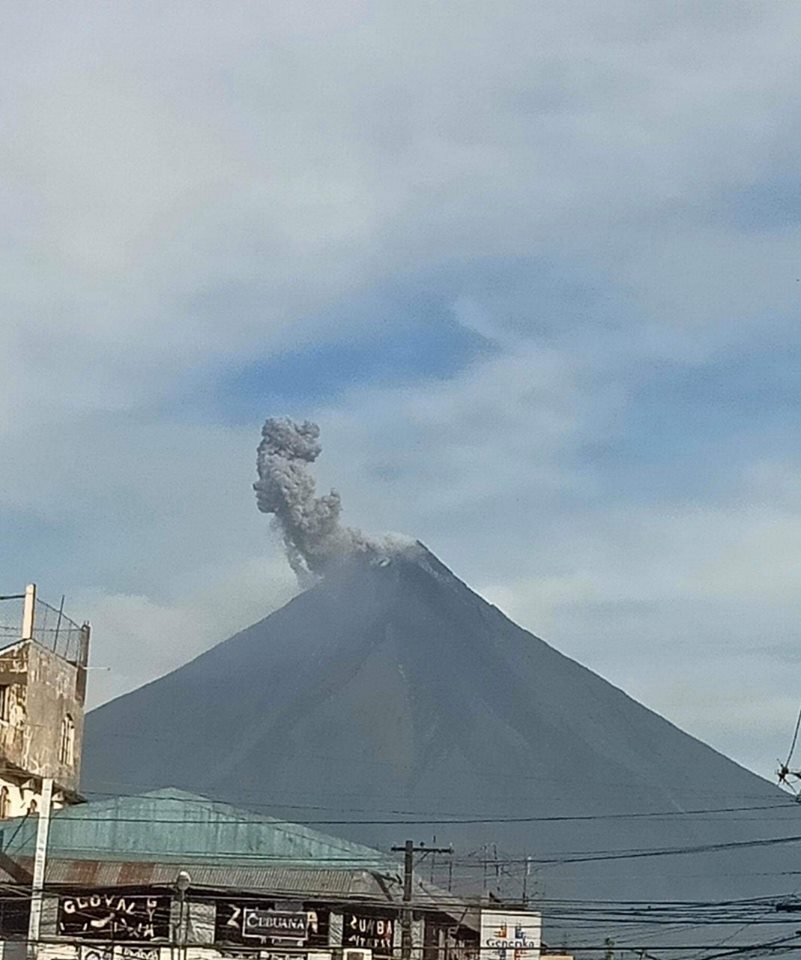
Philippines , Mayon :
MAYON VOLCANO BULLETIN 13 March 2019 08:00 A.M.
Mayon Volcano’s seismic monitoring network recorded three (3) volcanic earthquakes and four (4) rockfall events during the 24-hour observation period. Three of these earthquakes were related to phreatic eruption events that occurred at 3:10 PM, 3:18 PM, and 3:34 PM yesterday. These events generated light brown to grayish ash plume that rose 500 meters, 1000 meters, and 500 meters above the summit, respectively, before drifting southwest. Weak to moderate emission of white steam-laden plumes was observed creeping downslope around early morning to early afternoon, but was observed to rise up to 250 meters above the summit before drifting south-southwest, west-southwest and southwest in the afternoon. Faint crater glow from the summit could be observed at night. Sulfur dioxide (SO2) emission was measured at an average of 988 tonnes/day on 7 March 2019.
Alert Level 2 currently prevails over Mayon Volcano. This means that Mayon is at a moderate level of unrest. DOST-PHIVOLCS reminds the public that sudden explosions, lava collapses, pyroclastic density currents or PDCs and ashfall can still occur and threaten areas in the upper to middle slopes of Mayon. DOST-PHIVOLCS recommends that entry into the six kilometer-radius Permanent Danger Zone or PDZ and a precautionary seven kilometer-radius Extended Danger Zone or EDZ in the south-southwest to east-northeast sector, stretching from Anoling, Camalig to Sta. Misericordia, Sto. Domingo must be strictly prohibited. People residing close to these danger areas are also advised to observe precautions associated with rockfalls, PDCs and ashfall. Active stream/river channels and those identified as perennially lahar-prone areas on all sectors of the volcano should also be avoided especially during extreme weather conditions when there is heavy and prolonged rainfall. Civil aviation authorities must advise pilots to avoid flying close to the volcano’s summit as airborne ash and ballistic fragments from sudden explosions and PDCs may pose hazards to aircrafts.
Source : Phivolcs.
Photo : CNN Philippines
Colombia , Chiles / Cerro Negro :
Weekly activity bulletin Chiles and Cerro Negro volcanoes
The activity level of volcanoes continues at the level: YELLOW LEVEL ■ (III): CHANGES IN THE BEHAVIOR OF THE VOLCANIC ACTIVITY.
Following the activity of the CHILE volcanoes and CERRO NEGRO, the COLOMBIAN GEOLOGICAL SERVICE (SGC) reports that:
For the period evaluated, between 5 and 11 March 2019 compared to the previous week, seismic activity in the Chiles – Cerro Negro volcanoes region recorded a decrease in frequency and released seismic energy. Most of the recorded earthquakes continue to be associated with fractures of the rock within the volcano, being preferably located south-west-west of the Chiles volcano, at epicentral distances of less than 4 km and depths between 2 and 6 km below the summit (4700 m). Some events have been located in the southeast at distances of 5.5 to 10 km and at depths less than 11 km. The maximum local magnitude of events recorded during the evaluated period was M1.8 on the Richter scale.
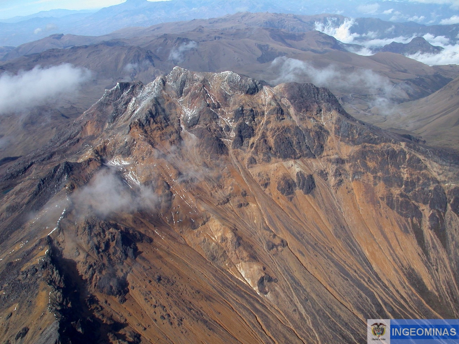
The earthquake recorded on March 12 at 12:53, located 7.2 km southeast of the Chiles volcano, with a depth of 9.7 km and a local magnitude of M 2.9 is highlighted, indicated as having been felt by the inhabitants of the indigenous reserve of Chiles, municipality of Cumbal (Nariño).
The other geophysical and geochemical assessment parameters do not show significant variations.
The COLOMBIAN GEOLOGICAL SERVICE is attentive to the evolution of the volcanic phenomenon and will continue to inform in a timely manner of the observed changes.
Source : SGC
Photo : Ingeominas
Hawaii , Kilauea :
19°25’16 » N 155°17’13 » W,
Summit Elevation 4091 ft (1247 m)
Current Volcano Alert Level: ADVISORY
Current Aviation Color Code: YELLOW
Activity Summary:
Kīlauea Volcano is not erupting. Rates of seismicity, deformation, and gas emissions have not changed significantly over the past week.
Observations:
This past week saw no significant change in volcanic activity. Low rates of seismicity continue across the volcano, with earthquakes occurring primarily in the summit and south flank regions. GPS stations and tiltmeters continue to show motions consistent with refilling of the deep East Rift Zone magma reservoir. Sulfur dioxide emission rates from the summit and from Puʻu ʻŌʻō remain low. These rates have been steady over the past several weeks.

View of the Halema’uma’u crater from the western edge of the caldera at the top of Kīlauea. USGS photo: J. Kauahikaua, 03 March 2019
Hazards remain in the lower East Rift Zone eruption area and at the Kīlauea summit. Residents and visitors near the 2018 fissures, lava flows, and summit collapse area should heed Hawaii County Civil Defense and National Park warnings. Please note that Hawaii County maintains a closure of the entire lava flow field and eruptive vents, prohibiting access unless authorized through Civil Defense.
The Hawaiian Volcano Observatory (HVO) continues to closely monitor Kīlauea’s seismicity, deformation, and gas emissions for any sign of increased activity. HVO maintains visual surveillance of the volcano with web cameras and occasional field visits. HVO will continue to issue a weekly update (every Tuesday) and additional messages as warranted by changing activity.
Source : HVO
Photo : USGS , J. Kauahikaua, 03 mars 2019
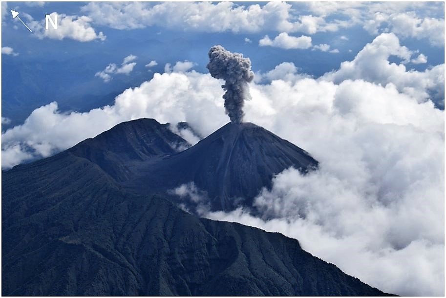
Ecuador , Reventador :
TUESDAY, MARCH 12, 2019, Information Geophysical Institute – EPN
Surface Activity Level: High, Surface Trend: No Change
Internal activity level: High, Internal trend: No change
Seismicity (events):
From 11 March 2019 at 11:00 until 12 March 2019 at 11:00, it has been registered:
29 events of type Long Period (LP).
33 explosions (EXP).
3 emission tremors (TE).
1 harmonic tremor (TA).
Gas flow (SO2) (ton / day): 282.0 +/- 35.0 Number of measures validated: 6
Rain / lahars:
No rain recorded
Emission column / ash:
During the last 24 hours, the area remained cloudy, so there was no observation of activity at the surface.
Other monitoring parameters:
Unchanged.
Observations:
In the early morning, an incandescence and the emission of blocks from all sides of the volcano were observed up to 300 meters below the level of the crater. The observation of the events was carried out during 12 hours of operation of the reference station.
Information National Service for Risk Management and Emergencies (SNGRE) (www.gestionderiesgos.gob.ec)
Alert level: Orange
Source : IGEPN
Photo : Auteur inconnu.
Nicaragua , San Cristobal :
INFORMATION BULLETIN ON VOLCANIC ACTIVITY, March 5, 2019.
VOLCANO OF SAN CRISTÓBAL: At 15:50, the volcano San Cristobal recorded an explosion of gas and ash, which rose about 400 meters above the edge of the crater, moving to the southwest. At this time, the real-time seismic amplitude (RSAM) ranged from 40 to 280 units, indicating that it was a low-energy explosion.

After the explosion, the values of the RSAM returned to their values of relative calm, ranging between 40 and 80 units, values retained at the time of writing this report.
Source : Ineter
Photo : Auteur inconnu.


No comment yet, add your voice below!