
March 08 , 2019 .
La Réunion , Piton de la Fournaise :
Activity bulletin from Thursday, March 7, 2019 to 11:45 (local time).
The eruptive activity that resumed on February 19, 2019 at Piton de la Fournaise around 7:10 pm local time continues.
Following the opening of a new crack on 05 March 2019 (between 09h and 19h, local time), north-west of Piton Madoré (1800m altitude), at a distance of about 150 m from the vent eruptive February 19, new eruptive fissures opened this morning in the area. At least 6 points of emission were visible this morning around the Piton Madoré.
For lack of aerial reconnaissance by a team of the OVPF (because of the bad weather conditions) it is impossible for the moment to affirm if these 6 emission points are all new eruptive fissures or if some are hornitos (formations mounds throwing lava, born from overpressure within a lava tunnel).
Activity bulletin of Thursday, March 7, 2019 at 15:00 (local time).
The eruptive activity that resumed on February 19, 2019 at Piton de la Fournaise around 7:10 pm local time continues. A slight increase in the intensity of the eruptive tremor has been observed for 24 hours.
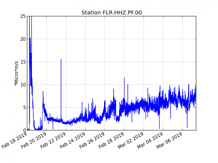
The eruptive activity that resumed on February 19, 2019 at Piton de la Fournaise around 7:10 pm local time continues. A slight increase in the intensity of the eruptive tremor has been observed for 24 hours. (© OVPFIPGP)
– Over the last 36 hours, 7 superficial superficial volcano-tectonic earthquakes (above sea level) have been recorded. Many earthquakes (which can not be counted) of low magnitude are also recorded at the eruptive site.
– After a deflation of the building related to the transfer of magma that occurred on 18/02/2019, the deformations of the summit zone do not show any particular signals.
– The CO2 concentrations in the near-field soil (cottage volcano area) remain high.
– Over the last 36 hours, surface flows estimated from satellite data, via the HOTVOLC platform (OPGC – University of Auvergne), fluctuated between <1 and 12 m3 / s (these measures may be affected / reduced by the cloud cover).
;
As indicated in this morning’s OVPF press release (11:45 am local time), following the opening of a new crack on 05 March 2019 (between 09:00 and 19:00 local time), north-west of Piton Madoré ( 1800m above sea level), at a distance of about 150 m from the eruptive vent of February 19, new eruptive fissures opened this morning in the area. At least 6 emission points were visible around Piton Madoré. On the other hand for lack of aerial reconnaissance by a team of the OVPF (because of the bad weather conditions) it is impossible for the moment to affirm if these 6 emission points are all new eruptive cracks, or if it is It is an extension of the one opened on February 19, or if some are hornitos (mound formations projecting lava, born from overpressure in a lava tunnel).
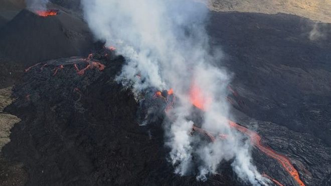
Figure 2: Shooting of the eruptive site on the morning of 06 March 2019. (© Corail Helicopter) (© Helicopter Coral)
The presence of numerous small-magnitude earthquakes in the area of the current eruptive site confirms that the environment, already very weakened, continues to crack due to the pressurization of the deepening system that continues. We can not exclude the opening of new fissures either at the level of the current eruptive site, or upstream or downstream from it in the coming days.
Niveau d’alerte : Alerte 2-2.
Source : OVPF
Video : Ben celui ci
Indonesia , Mérapi :
7.54°S, 110.446°E
Elevation 2910 m
Mount Merapi spews hot ash.
The Mount Merapi volcano saw an increase in volcanic activity on Thursday, spewing hot ash twice in the morning.
The first eruption occurred at 7:44 a.m., reaching 1,200 meters in height and lasting 121 seconds, while the second one came at 10:17 a.m., reaching 1,000 meters in height and lasting 97 seconds.
Despite the heightened activity, residents were told to remain calm and go on about their activities as usual.
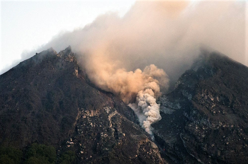
Thick smoke billows from Mount Merapi on the border between Yogyakarta and Central Java on Monday morning. Ash was reported to have fallen in several places in nearby Klaten regency. (The Jakarta Post/Tarko sudiarno )
“The residents are still within a safe distance [from the hot ash],” the Geological Disaster Technology Research and Development Center (BPPTKG) wrote on its Twitter account.
As the latest development was not considered a threat to local residents living on Merapi’s slopes, the BPPTKG decided to maintain the alert level at waspada (caution), the second-highest level in the country’s four-tiered alert system.
However, it advised residents and tourists to steer clear of a 3-kilometer radius of the peak of the mountain to avoid any possible danger.
PVMBG reported that during 22 February-5 March the volume of the lava dome in Merapi’s summit crater had not changed since the last measurement of 466,000 cubic meters estimated on 21 February. There were no apparent morphological changes; most of the extruded lava fell into the upper parts of the Gendol River drainage on the SE flank. Block-and-ash flows traveled 600-1,100 m down the Gendol drainage on 25 and 27 February, and on 2 March as many as 10 traveled as far as 2 km. Incandescent avalanches were visible at night. The Alert Level remained at 2 (on a scale of 1-4), and residents were warned to remain outside of the 3-km exclusion zone.
Source : The Jakarta Post. PVMBG , GVP .
Chile , Chaiten :
During the evaluated period, a total of 42 seismic events were recorded, of which 37 were classified as being of the volcano-tectonic (VT) type, associated with rock fracturing processes. The event of greatest energy had a local magnitude (ML) equal to M 1.8, and was located 1.7 km east-northeast of the center of the dome, at a depth of 3.3 km. Also, five hybrid seismic events (HB) were recorded, in relation to a complex mechanism (fracturing process of rigid material and dynamic of the fluids inside the volcanic edifice), the most important presented a value reduced displacement (DRc) equal to 3.1 cm2.
The images provided by the IP cameras installed around the volcano, showed a superficial activity of a maximum height of 700m and an incandescence during the night.
No sulfur dioxide (S02) emissions have been reported in the area near the volcanic building, according to data published by the Ozone Observatory Sulfur Dioxide Group (http: // mon2.gsfc.nasa.gov/). ) and the National Information and Satellite Data Service on the Environment (NESDIS) (http://satepsanoine.nesdis.noaa.gov).
9 thermal warnings were reported in the area associated with the volcanic complex during the period, with a maximum PVR of 2.5 MW, considered low, according to the data processed by infrared observation. of volcanic activity (MIROVA) (http://www.mirovaweb.it/) and Temporal Thermal Monitoring of global hot spots (MODVOLC) (http://modis.higp.hawaii.edu/).
The activity remains at levels considered low and suggest a relative stability of the volcanic system.
Because of the above, the volcanic warning is kept at the level:
GREEN LEVEL: Changes in the behavior of volcanic activity – Probable time for an eruption: WEEKS / MONTH.
Source : Sernageomin.
Photo : Paty Santini
Philippines , Mayon :
MAYON VOLCANO BULLETIN 08 March 2019 08:00 A.M.
Mayon Volcano’s seismic monitoring network recorded six (6) volcanic earthquakes and two (2) rockfall events during the 24-hour observation period. Two of these earthquakes were related to phreatic eruption events that occurred at 8:11 AM yesterday and 6:27 AM today. These phreatic events generated 500- and 300-m high grayish ash plume from the summit before drifting southwest, respectively. Moderate emission of white steam-laden plumes before drifting west-northwest, west-southwest and west was observed. Fair crater glow from the summit could be observed at night. Sulfur dioxide (SO2) emission was measured at an average of 988 tonnes/day on 7 March 2019. Precise leveling data obtained on 25 January-03 February 2019 indicate a slight deflation of the edifice relative to 08-13 December 2018. However, continuous GPS and electronic tilt data show inflation of the mid-slopes since June 2018.
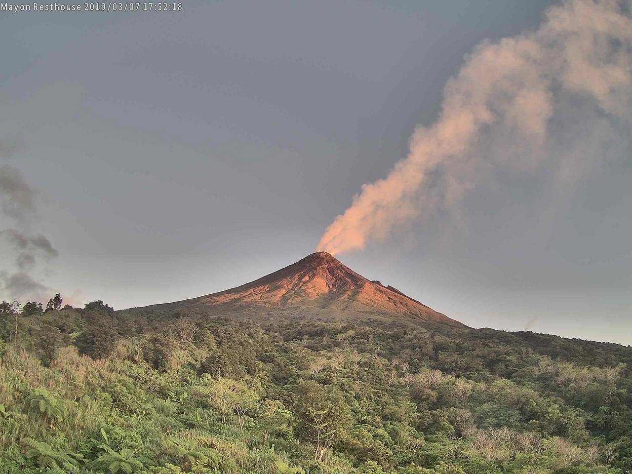
Gas and light ash plume from Mayon at sunset today (Resthouse webcam)
Alert Level 2 currently prevails over Mayon Volcano. This means that Mayon is at a moderate level of unrest. DOST-PHIVOLCS reminds the public that sudden explosions, lava collapses, pyroclastic density currents or PDCs and ashfall can still occur and threaten areas in the upper to middle slopes of Mayon. DOST-PHIVOLCS recommends that entry into the six kilometer-radius Permanent Danger Zone or PDZ and a precautionary seven kilometer-radius Extended Danger Zone or EDZ in the south-southwest to east-northeast sector, stretching from Anoling, Camalig to Sta. Misericordia, Sto. Domingo must be strictly prohibited. People residing close to these danger areas are also advised to observe precautions associated with rockfalls, PDCs and ashfall.
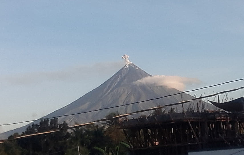
Mayon Volcano spews small amount of grayish ash plumes around 6:27 a.m. on Friday.
Active stream/river channels and those identified as perennially lahar-prone areas on all sectors of the volcano should also be avoided especially during extreme weather conditions when there is heavy and prolonged rainfall. Civil aviation authorities must advise pilots to avoid flying close to the volcano’s summit as airborne ash and ballistic fragments from sudden explosions and PDCs may pose hazards to aircrafts.
Source : Phivolcs
Photos : Volcanodiscovery.
Montserrat , Soufrière Hills :
MVO Weekly Report for the Period 22 February 2019 – March 1st 2019
Activity at the Soufrière Hills Volcano remains low.
The seismic network recorded no volcanic events this week.
SO2 flux measurements were taken from the helicopter on February 22nd and 27th, with eight traverses on each day. The average flux values were 541 tonnes per day on the 22nd and 184 tonnes per day on 27th.
Pyroclastic flows can occur at any time without warning on any side of the volcano, including Gages from where they can travel rapidly into Plymouth. Tracks across the Belham Valley can be destroyed or heavily modified by flash flooding or lahars, and caution should be exercised crossing the valley during and after rainfall.
The Hazard Level is 1.
There is no public access to Zone V, including Plymouth. Maritime Zones E and W are daytime transit only between sunrise and sunset (boats may sail through the zone but must not stop). Anyone who ignores these restrictions is liable to be prosecuted.
Source : MVO
Photo : BatakLagu.com


No comment yet, add your voice below!