
February 03 , 2019.
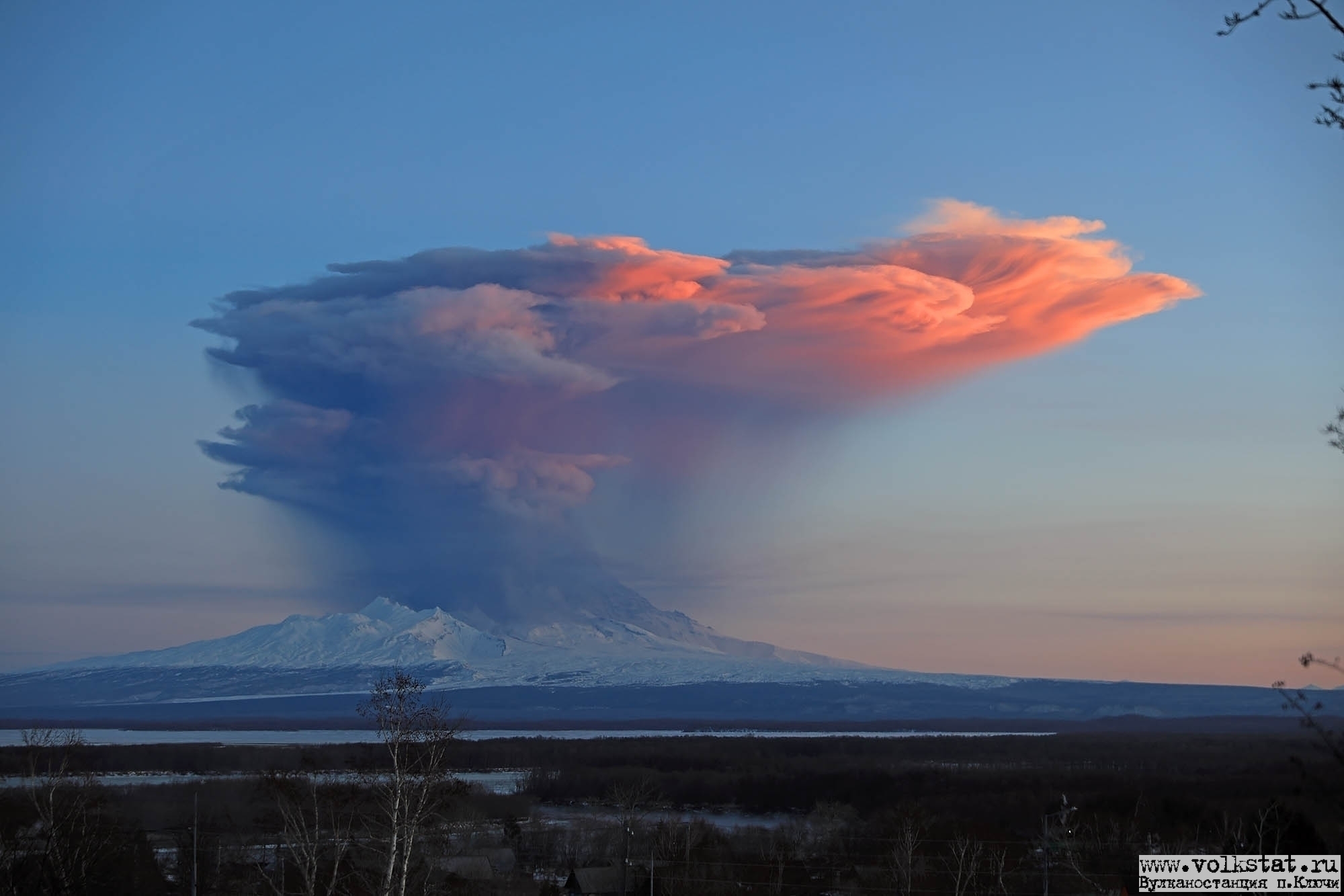
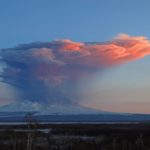
Kamchatka , Sheveluch :
VOLCANO OBSERVATORY NOTICE FOR AVIATION (VONA).
Issued: February 03 , 2019
Volcano:Sheveluch (CAVW #300270)
Current aviation colour code:ORANGE
Previous aviation colour code:orange
Source:KVERT
Notice Number:2019-32
Volcano Location:N 56 deg 38 min E 161 deg 18 min
Area:Kamchatka, Russia
Summit Elevation:10768.24 ft (3283 m), the dome elevation ~8200 ft (2500 m)
Volcanic Activity Summary:
A growth of the lava dome continues (a viscous lava blocks extrude out on the northern part of it), a strong fumarolic activity and an incandescence of the dome blocks and hot avalanches accompanies this process. According to satellite data, a gas-steam plume with some amount of ash continues to drift to the south-west from the volcano.
Explosive-extrusive eruption of the volcano continues. Ash explosions up to 32,800-49,200 ft (10-15 km) a.s.l. could occur at any time. Ongoing activity could affect international and low-flying aircraft.
Volcanic cloud height:
11480-13120 ft (3500-4000 m) AMSL Time and method of ash plume/cloud height determination: 20190203/0314Z – VIRS
Other volcanic cloud information:
Distance of ash plume/cloud of the volcano: 49 mi (79 km)
Direction of drift of ash plume/cloud of the volcano: SW / azimuth 215 deg
Time and method of ash plume/cloud determination: 20190203/0314Z – VIRS
Source : Kvert.
Photo : Yu Demyanchuck / Volkstat ru.
Colombia , Nevado del Ruiz :
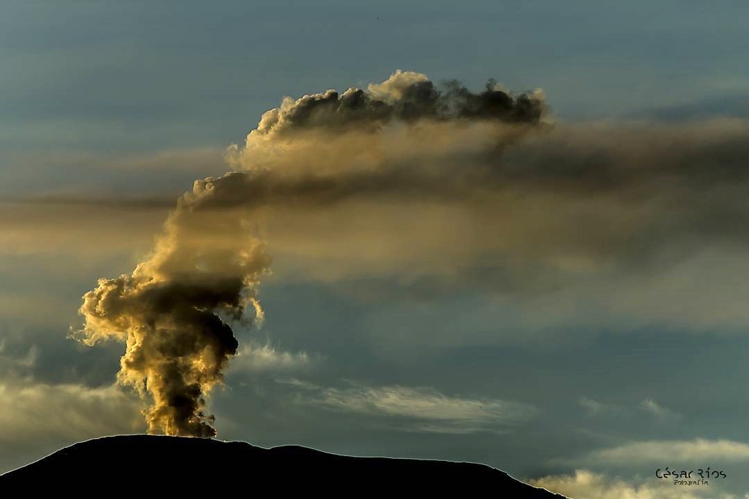
Weekly activity bulletin of the Nevado del Ruiz volcano
The level of activity continues at the level: Yellow activity level or (III): Modifications of the behavior of the volcanic activity.
With regard to monitoring the activity of the Nevado del Ruiz volcano, the COLOMBIAN GEOLOGICAL SERVICE announces that:
During the past week, seismicity induced by fracturing rocks part of the volcanic system resulted in a significant decrease in the number of earthquakes and seismic energy released over the previous week. Earthquakes were located mainly in the West-South-West, 4.7 km from the Arenas crater and, to a lesser extent in volcanic areas South-Southwest, Southeast, Northeast, and in the area of Arenas crater. The depths of the earthquakes ranged between 1.0 and 6.8 km. The maximum magnitude recorded during the week was 0.9 ML (local magnitude), corresponding to a recorded earthquake on 22 January at 17 h 42 (local time), located in the West-South-West, at a depth 5.4 km.
Seismicity related to fluid dynamics within the ducts of the volcanic structure also showed similar levels in the number of earthquakes and released seismic energy compared to the previous week. This seismic activity was characterized by the appearance of slight pulses of volcanic tremor and earthquakes for a very long time. The earthquakes occurred mainly in the crater Arenas and its surroundings.
Volcanic deformation measured from electronic inclinometers has recorded slight changes in recent days, possibly associated with minor inflationary processes on the Nevado del Ruiz volcano.
The volcano continues to emit water vapor and gases into the atmosphere, among which is the sulfur dioxide (SO2), as evidenced by the values obtained by the SCANDOAS stations installed in the region of the volcano. satellite image analysis. During the week, the NASA FIRMS and MIROVA portals reported several low-energy thermal anomalies.
The column of gas and steam reached a maximum height of 800 m, measured at the top of the volcano on 27 January. The direction of dispersion of the column was governed by the direction of the wind in the region, which prevailed towards the northwest of the volcano.
The Nevado del Ruiz volcano continues at the level of activity yellow.
Source : SGC
Photo : Cesar Rios.
Philippines , Mayon :
MAYON VOLCANO BULLETIN 03 February 2019 08:00 A.M.
Mayon Volcano’s seismic monitoring network recorded one (1) volcanic earthquake during the 24-hour observation period. Fair crater glow from the summit could be observed at night. Sulfur dioxide (SO2) emission was measured at an average of 845 tonnes/day on 01 February 2019. Precise leveling data obtained on 08-13 December 2018 indicate a slight inflation of the edifice relative to 22-31 October 2018. Continuous GPS and electronic tilt data further show pronounced inflation of the mid-slopes since June 2018, possibly due to aseismic magma intrusion deep beneath the edifice.

Alert Level 2 currently prevails over Mayon Volcano. This means that Mayon is at a moderate level of unrest. DOST-PHIVOLCS reminds the public that sudden explosions, lava collapses, pyroclastic density currents or PDCs and ashfall can still occur and threaten areas in the upper to middle slopes of Mayon. DOST-PHIVOLCS recommends that entry into the six kilometer-radius Permanent Danger Zone or PDZ and a precautionary seven kilometer-radius Extended Danger Zone or EDZ in the south-southwest to east-northeast sector, stretching from Anoling, Camalig to Sta. Misericordia, Sto. Domingo must be strictly prohibited. People residing close to these danger areas are also advised to observe precautions associated with rockfalls, PDCs and ashfall. Active stream/river channels and those identified as perennially lahar-prone areas on all sectors of the volcano should also be avoided especially during extreme weather conditions when there is heavy and prolonged rainfall. Civil aviation authorities must advise pilots to avoid flying close to the volcano’s summit as airborne ash and ballistic fragments from sudden explosions and PDCs may pose hazards to aircrafts.
Source : Phivolcs.
Photo : Omegashots
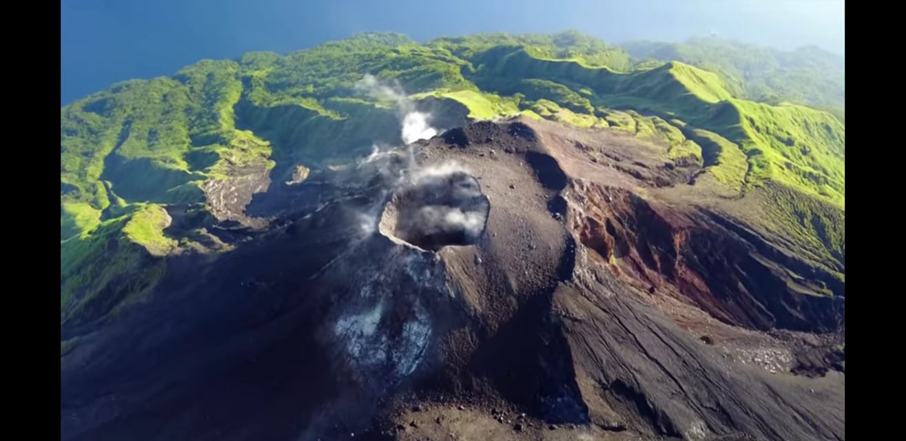
Indonesia , Karangetang :
Brief report on the observation of the ongoing activities of G. Karangetang, February 3, 2019
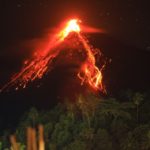
On February 2, 2019, a visual observation of the latest activities of Karangetang from the village of Batubulan was carried out. The observations were made by Yudia and Didi (observers of the Karangetang volcano). According to the observations made at about 10.45 am, the end of the avalanche and / or lava flow towards the Batuare River was observed as far as 2000 m from crater 2 (North) and avalanches and / or collapses to the Melebuhe River (north-east of Crater 2 and east of Kali Batuare) are erratic.
The Avalanche advance to the Melebuhe River was 2500 m from Crater 2. At the extreme, an accumulation of volcanic material could result in the formation of heat clouds. The distance from the lava point in the Melebuhe River to the coast is about 1000 m (1 km). Between Kali Batuare and Kali Melebuhe, there is a village called Niambangeng, Kampung Batubulan, with about 8 families (~ 21 people: 9 men, 9 women and 3 children). The PVMBG through the observers of the volcano coordinated with the BPBD, the National Police and TNI the closure of the road from the west of the Batuare River to Kali Melebuhe. For the moment, the alternative route used the east lane.
Currently, the status of Gunung Karangetang is at Level III (SIAGA) with the following recommendations:
• Communities around Karangetang Mountain and visitors / tourists should not climb or operate within 2.5 km of Kawah 2 (North Crater) and Main Crater (South Crater) in the direction of North-East-South-West and 3 km North-West.
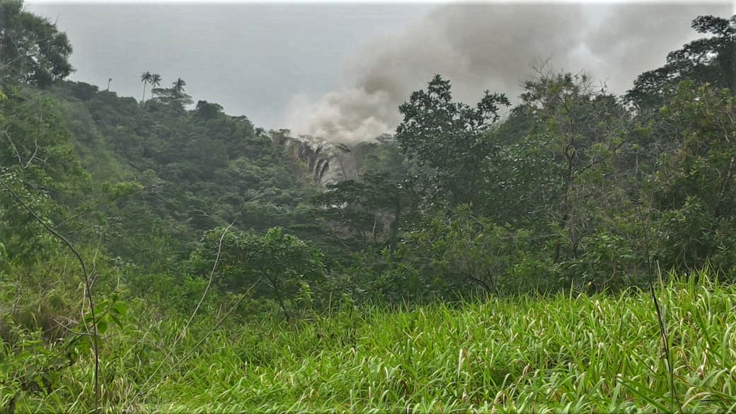
View of the lava avalanche, February 2, 2019 lk. 11:05 CET The advance of Karangetang lava leading to the Malebuhe River (Batubulan camp), has a distance of 2500m from the summit and its distance from the road is 500m
• People living around the rivers that descend from the summit of Mount Karangetang must be prepared for the potential threat of lahars and sudden floods that can spread to the coast.
• It is recommended that the community around Mount Karangetang prepare a mask for the nose and mouth to anticipate the potential danger of airway disruption in the event of ash rain.
Source : PVMBG
Photos : Novryoz Takalamingan , PVMBG
Seismic crisis in Mayotte:
A seismic activity has affected the island of Mayotte since the beginning of May 2018. These earthquakes form a swarm with epicentres grouped at sea, 30 to 60 km east of the coast of Mayotte. The vast majority of these earthquakes are of low magnitude, but several events of moderate magnitude (at most M5.9) have been strongly felt by the population and have damaged some buildings. Since the month of July the seismic activity has decreased but a seismicity persists which some earthquakes felt. In January, the month was particularly active with 21 earthquakes> Magnitude> 4. In parallel, data from the Teria network GPS stations installed on the island of Mayotte, which are distributed by the Geographical Institute’s RGP of the National Geographical Institute (IGN), always indicate since July an overall displacement towards the East (about 12 cm since July) and a subsidence (subsidence of about 5-10 cm according to the sites since July Automatic and daily calculations have been set up at the OVPF (via the Gipsy software) in order to follow these deformations, as well as the source at their origin.For the last 3 months, the source in « depressurization The origin of these displacements could be located about thirty km east of Mayotte and about 35-45 km deep, suggesting that fluid transfers in the crust are still continuing.
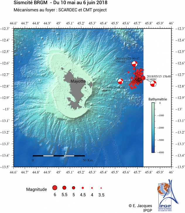
Situation point of January 30 00:00 (Mayotte local time).
We counted since our last point of situation of January 10, 98 earthquakes of magnitude greater than or equal to 3.5 (that is to say on average 5 per day) of which 13 earthquakes of magnitude greater than or equal 4.0.
Since November 2018, we can see that the level of seismic activity is stable and constant in intensity and number of events.
It should be noted that an earthquake was also detected 80 km NW of Mamoudzou on 29 January 07h21 (M: 3.7).
13 earthquakes over the period therefore had a magnitude greater than 4.0, of which 2 were detected by the USGS, but we also count 22 earthquakes with a magnitude slightly lower than this threshold (around 3.8-3.9).
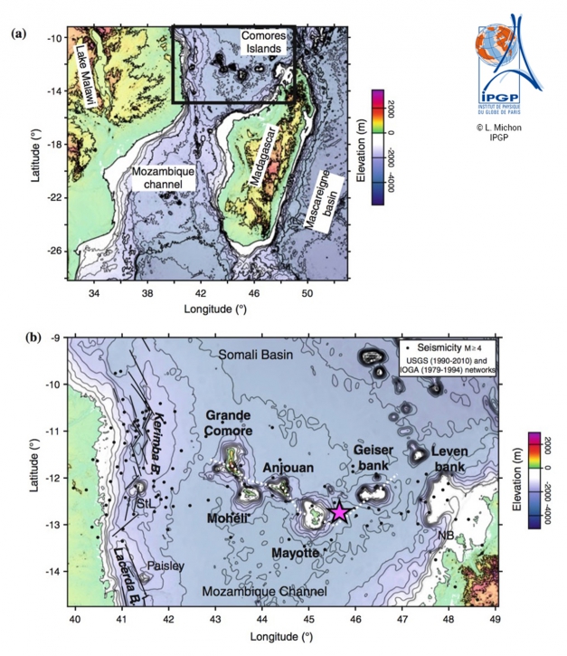
The island of Mayotte is part of the volcanic chain of the Comoros archipelago. Volcanism began about 20 million years ago, then spread to the west, forming successively the different islands of the archipelago, Mayotte, Anjouan, Mohéli, Grande Comore. The most recent volcanism is on Grande Comore, where the Karthala is a very active volcano whose last eruption was on January 12-15, 2007. On Mayotte, volcanism has continued, less actively, until current era, with the most recent dating back to the Quaternary (~ 4000 years). This volcanism and the moderate seismicity of this area are interpreted in two ways. This would be either the effect of a small hot spot, or a lithospheric deformation associated with the East African rift system.
Source : OVPF / BRGM


No comment yet, add your voice below!