
January 30 , 2019.
Colombia , Nevado del Huila :
Weekly activity bulletin of the Nevado del Huila volcano.
The level of activity of the volcano continues at the level: yellow activity level or (III): changes in the behavior of volcanic activity.
• Based on the analysis and evaluation of the information obtained through the surveillance network of the Nevado del Huila volcano, during the week of January 22 to 28, 2019, the Colombian Geological Service – Popayán Volcanological and Seismological Observatory reports that:
• Since January 26, 2019, seismic activity has increased in the area of influence of the Nevado del Huila volcano. This activity began with the recording of a magnitude 5.4 earthquake at 07:32 local time. , located 13 kilometers north-east of the central peak of the volcano Nevado del Huila, which was felt in Bogota, DC, Florencia (Caquetá), Popayán, Silvia (Cauca), Soacha, Fusagasugá, Funza, Facatativa, Tenjo, Chia , Girardot (Cundinamarca), La Plata, Neiva (Huila), Mocoa (Putumayo), Armenia (Quindío), Pereira, Santa Rosa de Cabal (Risaralda), Herveo, Espinal, Ibague, Planadas, Gaiaia (Tolima), Cali, Palmira , Pradera, Riofrio, Ulloa, Jamundí, Florida (Valle del Cauca), reporting damage to several buildings and falling rocks.
• On January 28, 2019 at 16:07 local time, another magnitude 4.7 event was presented, located 18 kilometers northeast of the central peak of the Nevado del Huila volcano and reported as having been felt in the departments of Antioquia, Caldas, Risaralda, Quindío, Tolima, Caqueta, Chocó, Cundinamarca, Santander, Boyacá, Meta, Valle del Cauca, Huila and Cauca.
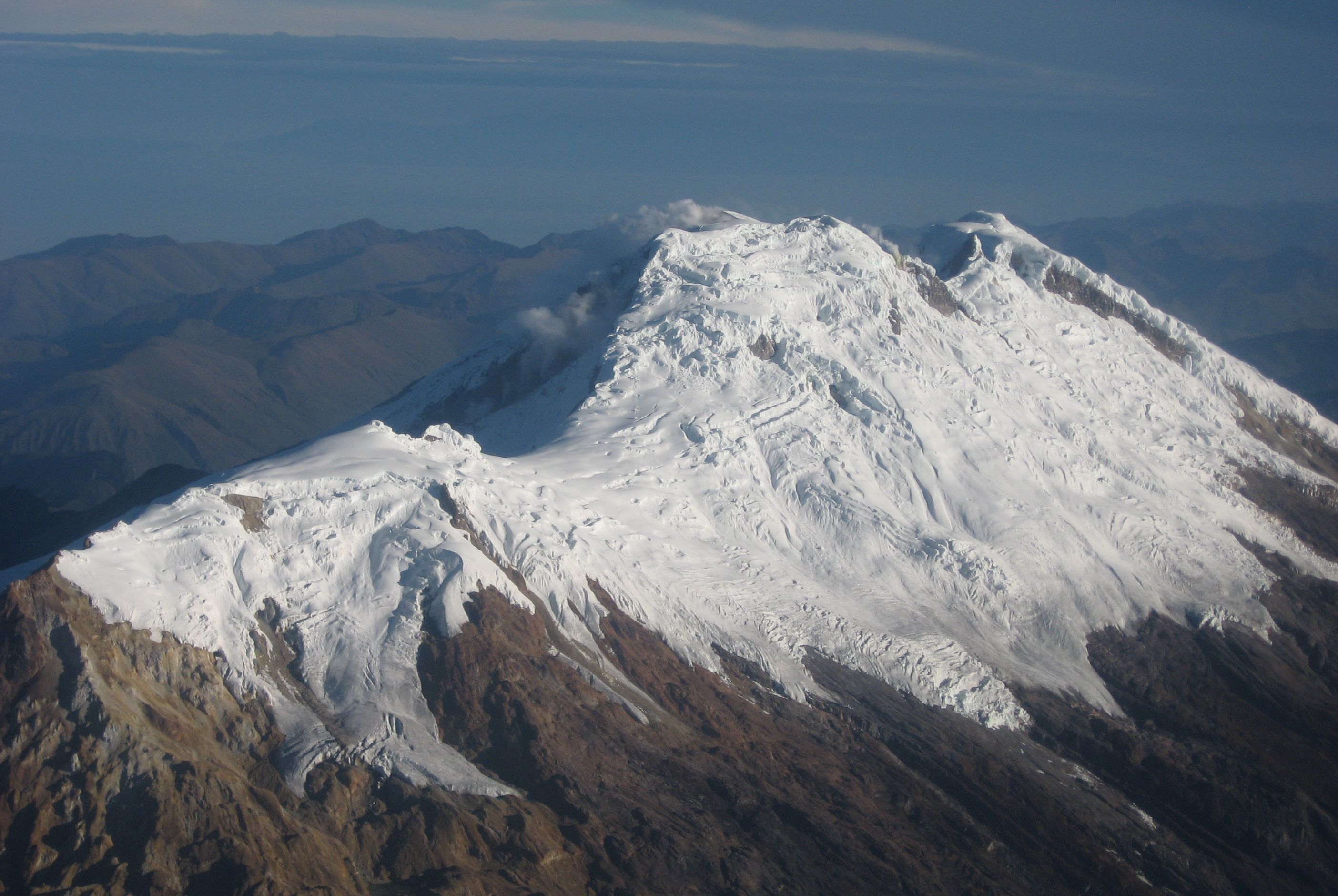
• Between the first event (January 26th) and the date of publication of this bulletin, about 8520 earthquakes have been recorded, most of them of low magnitude, recorded only by instruments located in the volcano’s area of influence.
The source of this seismicity is located northeast of the Nevado del Huila volcano, at distances between 10 and 20 kilometers and at depths between 5 and 15 kilometers from the altitude of 4530 meters from the summit.
• This seismicity highlights the occurrence of 46 other events with local magnitudes greater than or equal to 3, some of which have been reported as felt in the area of influence of the volcano.
• The images obtained during the week by the web cameras of Caloto, Tafxnú, Maravillas and La Palma showed a weak degassing of the volcanic system.
• Sensors for monitoring soil deformation, magnetic fields, and infrasound did not record any variations associated with changes in volcanic activity.
It is recalled that although the earthquakes are located in the zone of influence of the volcano Nevado del Huila, which is a tectonically active zone, these events are not located under the volcanic building and have not affected other parameters of volcanic monitoring. The level of activity of the volcano has not changed, which continues in yellow or level III.
Source : SGC.
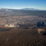
Hawaii , Kilauea :
19°25’16 » N 155°17’13 » W,
Summit Elevation 4091 ft (1247 m)
Current Volcano Alert Level: ADVISORY
Current Aviation Color Code: YELLOW
Activity Summary:
Kīlauea Volcano is not erupting. Rates of seismicity, deformation, and gas release have not changed significantly over the past week.
Observations:
Low rates of seismicity continue across the volcano, with events occurring primarily in the summit and south flank regions. Inflationary tilt in the middle East Rift Zone has slowed over the past week. Sulfur dioxide emission rates from the summit and Puʻu ʻŌʻō remain low.
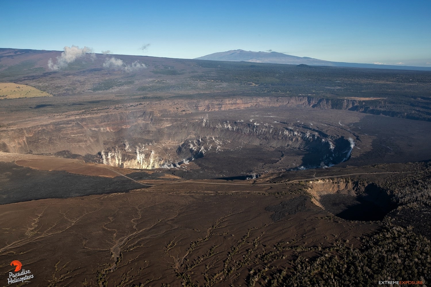
Caldera summit of Kilauea, with the crater of Halema’uma’u; in the background, Mauna Kea; in the foreground on the right, the crater Keanakakoi –
Hazards remain in the LERZ eruption area and at the Kīlauea summit. Residents and visitors near recently active fissures and lava flows should heed Hawaii County Civil Defense and National Park warnings, and be prepared, if necessary, to self-evacuate in the unlikely event of renewed activity. Please note that Hawaii County maintains a closure of the entire lava flow field and vents and prohibits access unless authorized through Civil Defense.
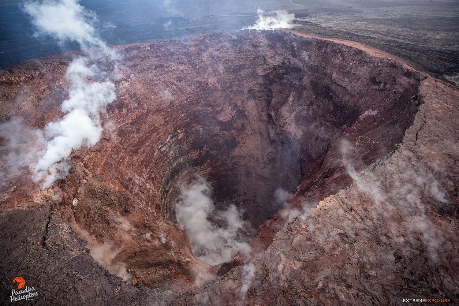
Kilauea East rift zone – the crater of Pu’u O’o.
The Hawaiian Volcano Observatory (HVO) continues to closely monitor Kīlauea’s seismicity, deformation, and gas emissions for any sign of reactivation. HVO maintains visual surveillance of the volcano with web cameras and occasional field visits. HVO will continue to issue a weekly update (every Tuesday) and additional messages as warranted by changing activity.
Source : HVO
Photos : Bruce Omori / Paradise helicopters .
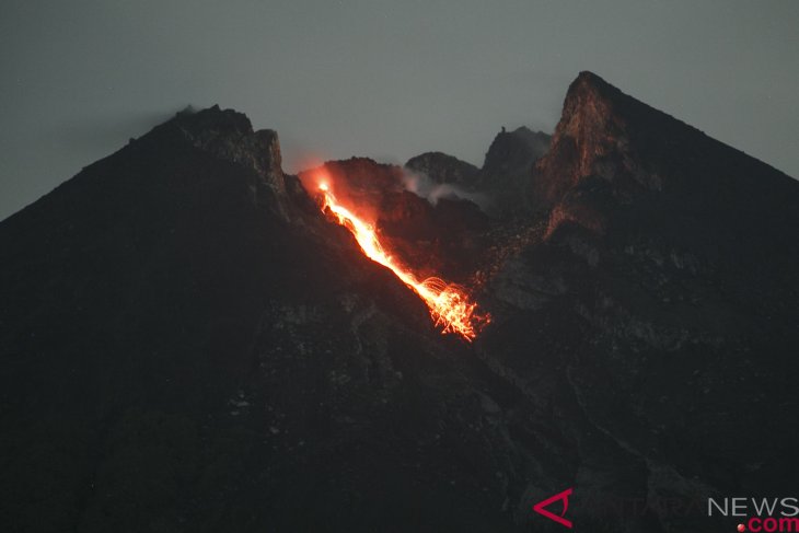
Indonésie , Merapi :
Yogyakarta. – Until Jan 29, Mount Merapi, located in Yogyakarta and Central Java, was recorded to have spewed incandescent lava from its crater, flowing down the volcano`s flanks eight times.
The Institute for Investigation and Development of Geological Seismicity Technology (BPPTKG) recorded incandescent lava avalanches traveling down Mount Merapi`s slopes eight times.
Through its official Twitter account, the BPPTKG stated that based on seismic data from 00.00-06.00 WIB, the volcano erupted, spewing eight lava avalanches, lasting for 22 to 66 seconds.
Four incandescent lava avalanches were observed via CCTV BPPTKG in the direction of Kali Gendol, with a sliding distance of 200 to 600 meters.
On Monday (Jan 28) from 6 a.m. to 10 p.m. WIB, the BPPTKG also recorded five earthquakes, with a duration of 16-26 seconds.
The last released morphological analysis of the lava dome of Mount Merapi by BPPTKG showed that the volume of the mountain lava dome had reached 461 thousand cubic meters, with a growth rate of 1,300 cubic meters per day, or smaller than the previous week.
Currently, lava domes are still stable, with a low growth rate, on an average, less than 20 thousand cubic meters per day.
The BPPTKG also reported that on January 18-24, 2019, the most active volcano in Indonesia experienced three gusts of earthquakes, one instance of a shallow volcanic earthquake, 223 avalanches caused by earthquakes, two earthquakes of low frequency, and a tectonic earthquake seven times.
Until now, the BPPTKG has continued to maintain the status of Mount Merapi at Level II, or Alert, and temporarily does not recommend climbing activities except for the purposes of investigation and research related to disaster mitigation efforts.
The BPPTKG has urged residents to not conduct activities within a three-kilometer radius from the summit of Mount Merapi.
Source : ANTARA News – Lugman Hakim, Eliswan Azly
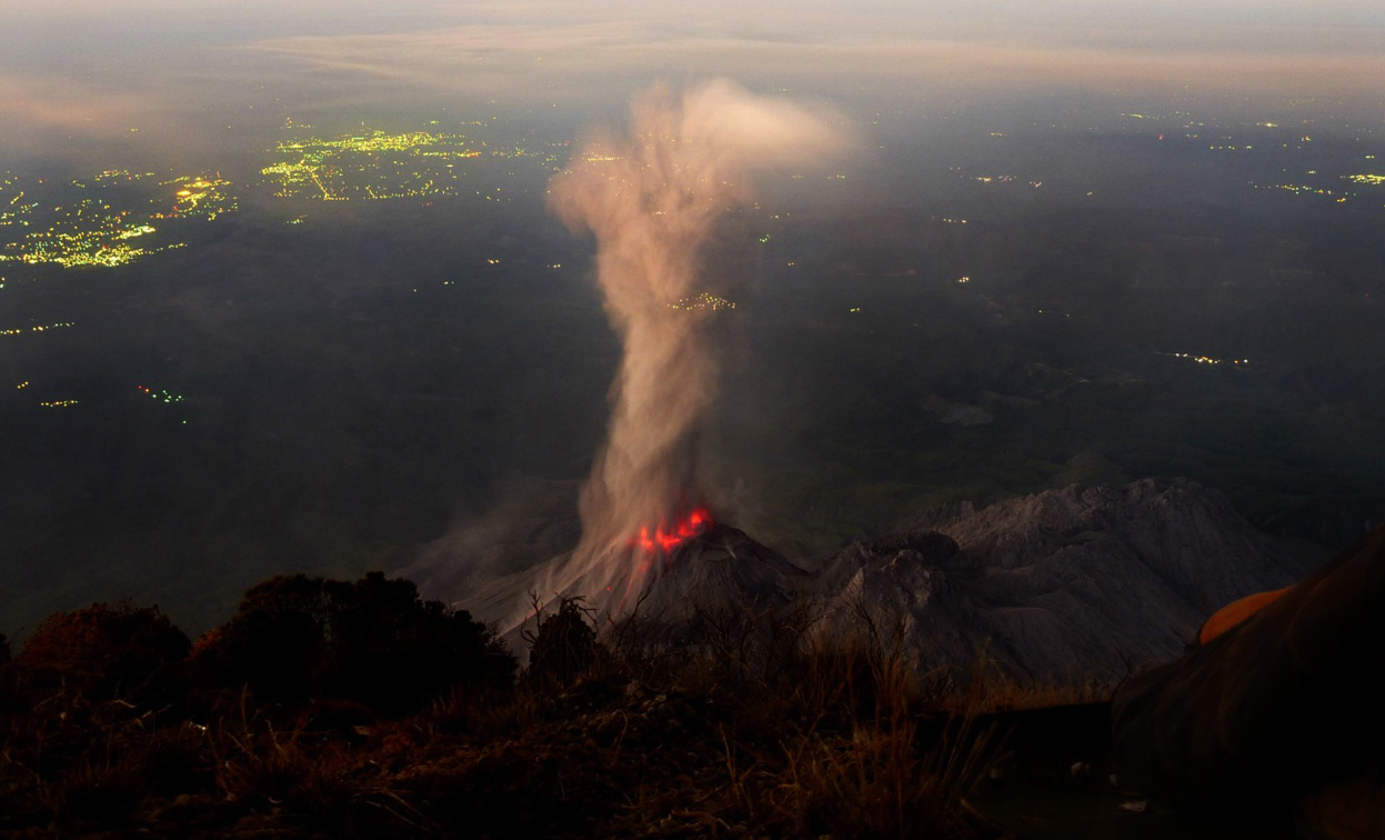
Guatemala , Santiaguito :
Attraction type: Pelean
Morphology: Complex of Dacitic Domes.
Geographical location: 14 ° 44 ’33 Latitude N; 91 ° 34’13˝Longitude W.
Height: 2,500msnm
Weather conditions: Clear weather
Wind: variable wind.
Precipitation: 0.0 mm.
Activity:
The crater of the Caliente Dome, with a white fumarole at low altitude towards the South, continues its activity with weak explosions accompanied by gray ash at an altitude of 2800 meters above sea level. These are scattered towards the South -Is on the area of Las Marías, Calaguache and others on this flank. Because of this activity, a smell of sulfur is reported in the village of Las Marías, due to the change of wind direction. Block avalanches continue from the Caliente Dome to the Northeast and East flanks. The seismic station STG3 records the activities generated by explosions and avalanches.
Source : Insivumeh .
Photo : Auteur Inconnu


No comment yet, add your voice below!