
January 07 , 2019.
El Salvador , San Miguel ( Chaparrastique ) :
Special Report 6. The Chaparrastique volcano continues to emit gases.
Date and time of publication: 06 January 2019, 12:00:00.
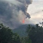
The Chaparrastique volcano continues to emit gases in a sustained manner (Figure 1). This degassing forms a column of gas oriented towards the West sometimes reaching 300 meters in height. These gases are associated with changes in the internal pressure of the volcano.
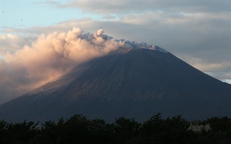
Figure 1. The emission of the volcano’s gas column is westerly
The seismicity of the volcano recorded by the VSM station, located one kilometer from the crater on the north flank, shows variations in the energy level.
The frequency spectrum of the seismicity of the volcano on Friday 4 and Saturday 5 January 2019 shows bands of 4 to 8.5 Hz, with spectral peaks between 5 and 7.5 Hz, that is to say frequencies high. A sudden change to frequencies below 4 Hz would be indicative of a process of depressurization and relaxation of the volcanic system that could be the precursor to high-energy eruptive activity. These changes on the Chaparrastique volcano can occur suddenly.
The seismic vibration (RSAM) values recorded over the past 24 hours continue to fluctuate between 100 and 139 units (with an average of 119 units per hour), considered higher than normal (Figure 2).
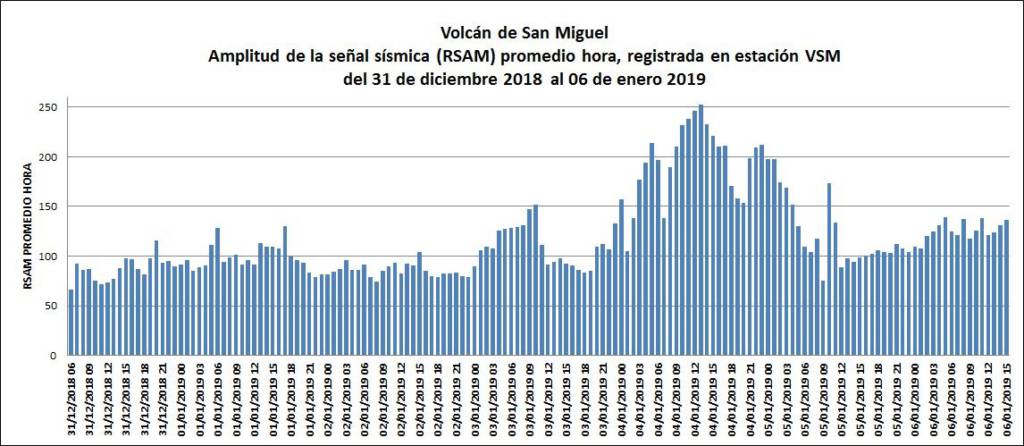
Figure 2. Behavior of seismic vibrations recorded last week
According to the observations, the amplitude of the seismic signal of the volcano during the last 10 hours has tended to stabilize below 150 units; However, the energy released is related to pressure changes in the internal system.
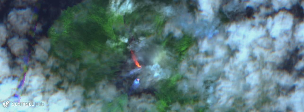
During this period, the local observer network (ROL) reports only the volcano’s gas emissions (Figure 3).
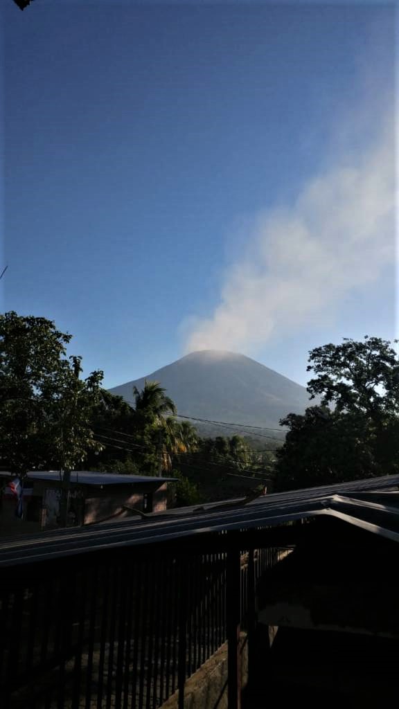
Figure 3. The images shared by the local observer network show the volcano’s gas emissions:
Source: MARN, photograph by Jorge Rivas, Local Observer Network, San Jorge, San Miguel.
Analysis of the current situation indicates that the volcano will continue with the degassing it has shown in recent days. Degassing could be accompanied by emissions of fine material transported in the direction of the prevailing wind and possibly reaching the populated areas to the west of the volcano, as well as a smell of sulfur in the areas between El Carreto, La Piedra and Piedra Azul.
In the event of a sudden increase in activity, the most likely scenario is the generation of an upper eruptive column, whose ashes could fall in the municipalities of San Rafael Oriente, San Jorge and Chinameca. The production of ballistic projectiles is included in this scenario and could reach up to three kilometers around the crater. However, the possible production of lava flows from the flanks of the volcano is not excluded.
MARN continues the systematic monitoring of the volcano and maintains close communication with the Directorate General of Civil Protection and the network of local observers. In addition, he calls on locals, tourists and mountaineers to stay away from the crater because of the sudden changes that often occur in their activity.
In the event of a material change, an advance special report will be published.
Source : Marn.
Indonesia , Karangetang :
Level of activity at Level III (SIAGA). G. Karangetang (2460 m altitude) has started an eruption period since 25 November 2018.
Since yesterday and until this morning, the volcano was clearly visible then was covered with fog. Smoke from the main crater is a whitish, thick color, up to 150 m above the summit of the peak. The wind was weak in the north and north-west
Through the seismographs, on January 6, 2019, it was recorded:
41 avalanche earthquakes
35 earthquakes
3 harmonic earthquakes
5 shallow volcanic earthquakes
9 distant tectonic earthquakes
3 hybrid earthquakes
A continuous tremor of amplitude 0.5 to 1 mm, and a dominant value at 0.5 mm
Recommendation:
The community around Mount Karangetang and visitors / tourists should not move up and within 2.5 km of Kawah 2 (North Crater) and Main Crater (South Crater) to Northeast-South- West and within a radius of 3 km northwest.
People living around the rivers that come from the summit of Mount Karangetang must be prepared to face the potential threat of lahars and sudden floods that may spread to the coast.
It is recommended that the community around Mount Karangetang prepare a mask for the nose and mouth to prevent the risk of airway disruption in case of ash rain.
VONA:
The YELLOW color code, issued November 25, 2018 at 13:32, was last sent, relating to a volcanic ash emission at an altitude of approximately 2284 m above sea level or approximately 500 m above the summit, the wind was blowing to the east.
Source : PVMBG.
Photos : Novryoz Takalamingan , Sentinel 2 . ( via Sherine France )
Philippines , Kanlaon :
KANLAON VOLCANO BULLETIN 07 January 2019 08:00 A.M.
Kanlaon Volcano’s seismic monitoring network recorded one (1) volcanic earthquake during the past 24 hours. Wispy emission of steam-laden plumes was observed. Ground deformation data from continuous GPS measurements indicate inflation of the edifice since December 2017. Sulfur dioxide (SO2) emission was measured at an average of 122 tonnes/day on 22 December 2018.
Alert Level 2 status prevails over Kanlaon Volcano, which means that the volcano is undergoing a moderate level of unrest due to probable intrusion of magma at depth that may or may not lead to a magmatic eruption. The local government units and the public are strictly reminded that entry into the 4-kilometer radius Permanent Danger Zone (PDZ) is strictly prohibited due to the further possibilities of sudden and hazardous steam-driven or phreatic eruptions. Civil aviation authorities must also advise pilots to avoid flying close to the volcano’s summit as ejecta from any sudden phreatic eruption can be hazardous to aircraft.
DOST-PHIVOLCS is closely monitoring Kanlaon Volcano’s activity and any new development will be relayed to all concerned.
Source : Phivolcs.
Mexico , Popocatepetl :
January 6, 2019 at 11:00 am (January 6 at 5:00 pm GMT)
During the past 24 hours, 186 exhalations have been identified through the monitoring systems of the Popocatépetl volcano, accompanied by water vapor, gas and sometimes small amounts of ash. In addition, 28 minutes of low amplitude harmonic tremor and three volcano-tectonic earthquakes were recorded, two yesterday at 22h23 and 22h30h preliminary magnitude M2.0 and today at 05:01 with a preliminary magnitude of M1,9.
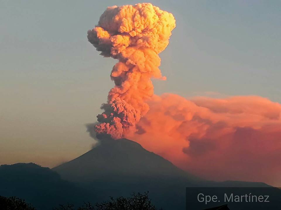
At the time of this report, we can observe a slight continuous emission of volcanic gases that disperse in the South-South-West direction.
CENAPRED urges DO NOT APPROACH the volcano and especially the crater, because of the risk of falling ballistic fragments, and in case of heavy rains to move away from the bottom of the ravines because of the risk of landslides and flows of mud.
The Popocatepetl volcanic warning light is located at Amarillo Phase 2.
Source : Cenapred .
Photo : GPE Martinez


No comment yet, add your voice below!