
December 31 , 2018.
Ecuador , Reventador :
The Reventador volcano recorded an incandescence in its crater and remains with a « high » eruptive activity.
The area where the Reventador volcano is located has remained covered over the past few hours, although the Institute of Geophysics has observed an incandescence of the crater of the volcano, which maintains a « high » eruptive activity. This was reported today (December 30, 2018) by the Institute of Geophysics of the National Polytechnic School on his Facebook profile, in which he stressed that « most of the time, the sector remained cloudy ».
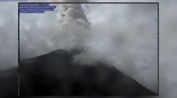
Nevertheless, « between the clouds, it was possible to observe several times the incandescence at the crater level. » The Reventador volcano is located about 90 kilometers from Quito, on a spur of the eastern branch of the Andean mountain range which disappears at the beginning of the Amazon basin. At an altitude of 3,560 meters, this volcano began its current eruptive process in 2002 and is characterized by the generation of explosions, gas and ash emissions, lava flows and lahars. In November 2002, an eruption of the Reventador caused the formation of a vast cloud of ashes which, under the effect of the wind, went to Quito and covered several parts of the capital.
Source : Diario EL COMERCIO https://www.elcomercio.com/actualidad/volcan-reventador-registro-incandescencia-amazonia.html?fbclid=IwAR0JaBZ86YASZ17F1nMhBMekXdXlhgRTsvdho5z.
Philippines , Mayon :
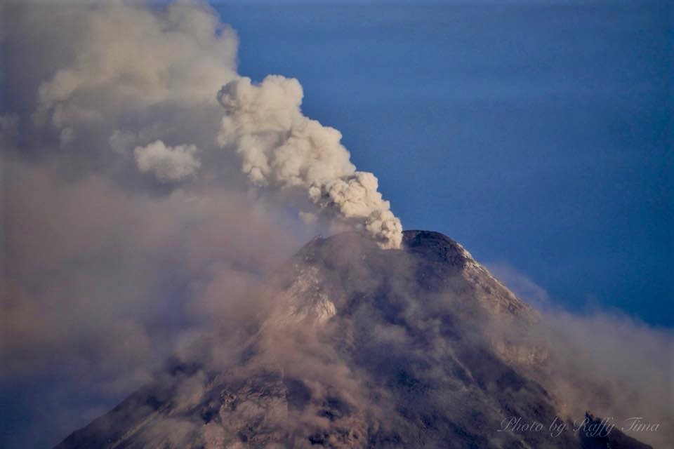
MAYON VOLCANO BULLETIN 31 December 2018 08:00 A.M.
Mayon Volcano’s seismic monitoring network recorded nine (9) volcanic earthquakes and two (2) rockfall events during the 24-hour observation period. Moderate emission of white steam-laden plumes that crept downslope before drifting west-northwest was observed. Sulfur dioxide (SO2) emission was measured at an average of 1,377 tonnes/day on 30 November 2018. Precise leveling data obtained on 08-13 December 2018 indicate a slight inflation of the edifice relative to 22-31 October 2018. Overall however, the volcano generally remains inflated relative to 2010 baselines. Electronic tilt data further show pronounced inflation of the mid-slopes beginning 25 June 2018, possibly due to aseismic magma intrusion deep beneath the edifice.
Alert Level 2 currently prevails over Mayon Volcano. This means that Mayon is at a moderate level of unrest. DOST-PHIVOLCS reminds the public that sudden explosions, lava collapses, pyroclastic density currents or PDCs and ashfall can still occur and threaten areas in the upper to middle slopes of Mayon. DOST-PHIVOLCS recommends that entry into the six kilometer-radius Permanent Danger Zone or PDZ and a precautionary seven kilometer-radius Extended Danger Zone or EDZ in the south-southwest to east-northeast sector, stretching from Anoling, Camalig to Sta. Misericordia, Sto. Domingo must be strictly prohibited. People residing close to these danger areas are also advised to observe precautions associated with rockfalls, PDCs and ashfall. Active stream/river channels and those identified as perennially lahar-prone areas on all sectors of the volcano should also be avoided especially during extreme weather conditions when there is heavy and prolonged rainfall. Civil aviation authorities must advise pilots to avoid flying close to the volcano’s summit as airborne ash and ballistic fragments from sudden explosions and PDCs may pose hazards to aircrafts.
Source : Phivolcs.
Photo : Raffy Tima
Indonesia , Agung :
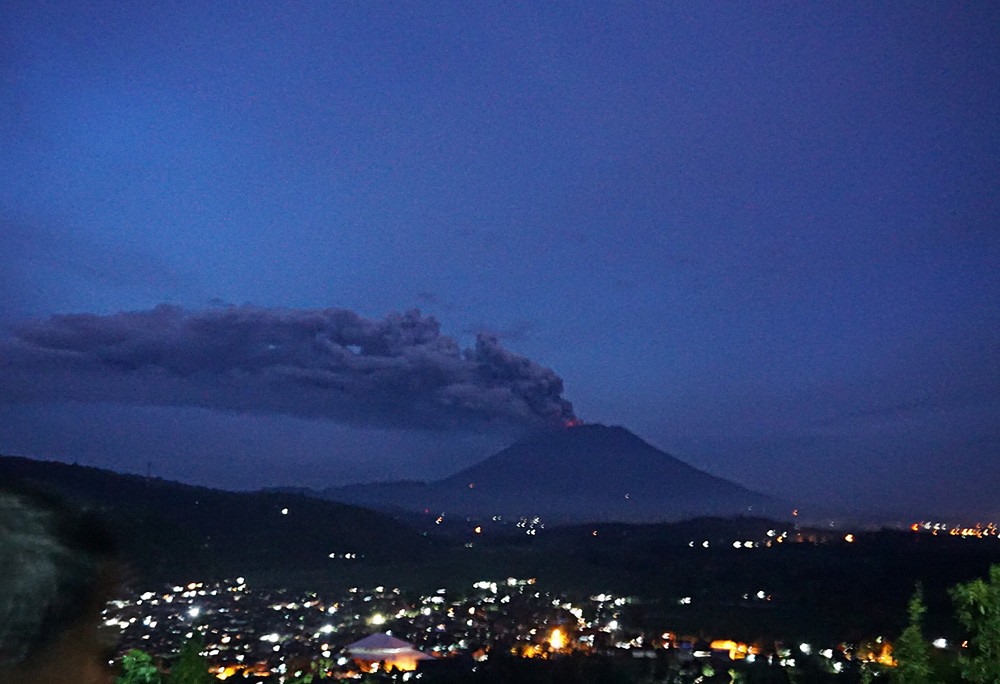
The Gunung Agung in Karangasem Regency, Bali again erupted on December 30, 2018 at 04:09 WITA for 3 minutes 8 seconds with an amplitude of 22 mm. The eruption is due to an « overpressure » due to the accumulation of volcanic gases. At the time of the eruption, incandescence was observed in the crater area, but the height of the ash column was not observed due to fog. According to satellite information, volcanic ash is moving towards the southeast, reaching an altitude of 5,500 m. Light ash rains were reported in the Karangasem regency, in the south-eastern sector of Mount Agung, as in the city of Amlapura and in several villages such as the villages of Seraya Barat, Seraya Tengah and Tenggalinggah.
Before this eruption, no significant increase in the intensity of seismicity was observed but several volcanic earthquakes were recorded, including an earthquake on the northern slope of Mount Agung on December 28, 2018 of magnitude M2.7 to 2 : 49 and M2.4 to 15:31. These earthquakes indicate the movement of magma towards the surface. Between 27 and 29 December 2018 (before the eruption), the MODIS satellites also showed no thermal anomaly on the surface of the Mount Agung crater, which did not indicate any fresh lava material on the surface of the crater.
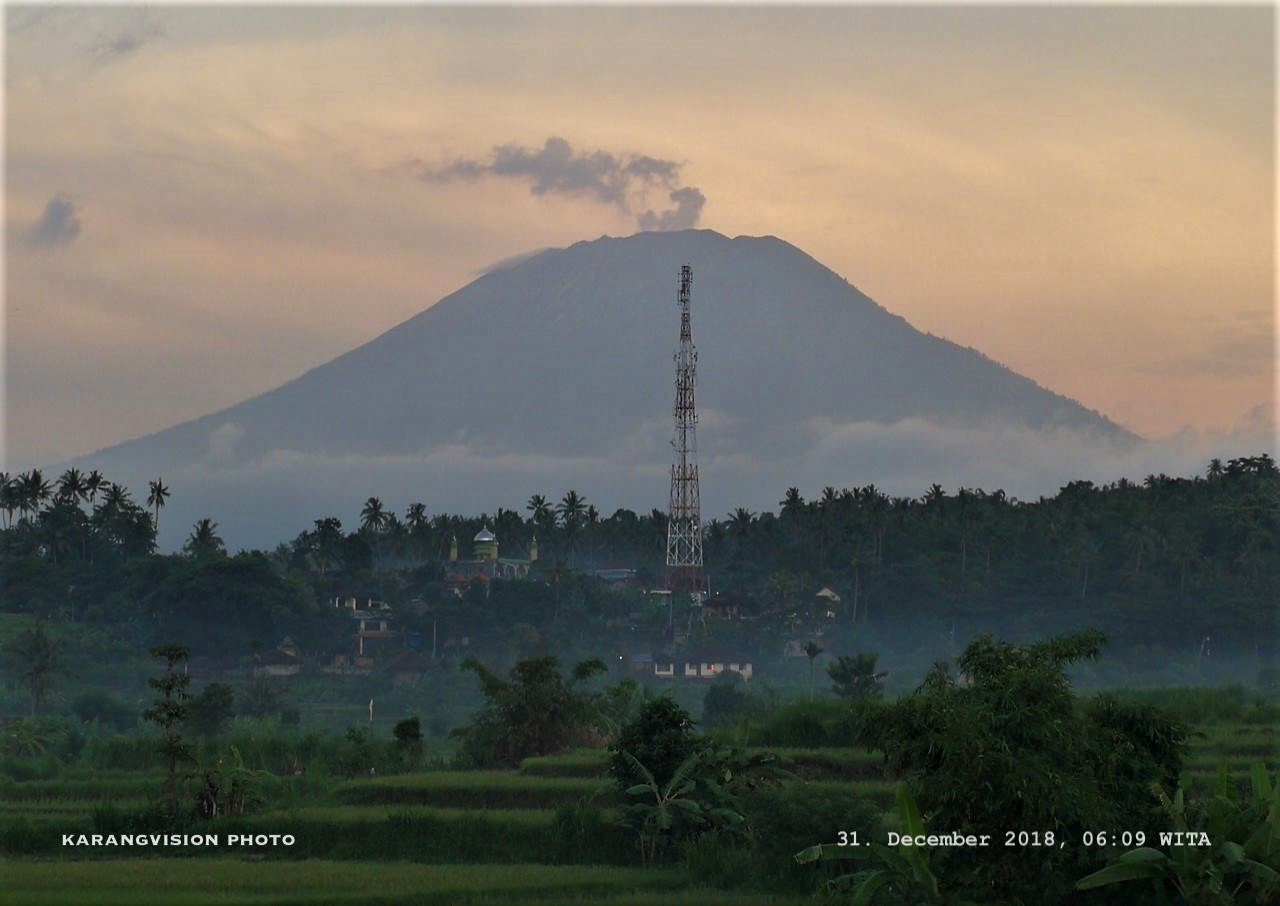
Level of activity at Level III (SIAGA). Mount Agung (3142 m above sea level) has erupted since November 21, 2017. Since yesterday and until this morning, the weather is cloudy, with light to moderate winds heading east. The volcano is clearly visible until it is covered with fog. The smoke of the main crater was observed at a height of about 700 meters, white and thin.
By means of the seismographs, on December 30, 2018, it was recorded:
1 earthquake of eruption / explosion
1 shallow volcanic earthquake
1 in a deep volcanic earthquake
3 emission earthquakes
4 distant tectonic earthquakes
Seismicity of December 31, 2018 (00: 00-06: 00):
1 distant tectonic earthquake.
Recommendation:
Communities around G. Agung and mountaineers / visitors / tourists should not be active in the estimated risk zone, ie in all areas within 4 km of Mount Agung.
The estimated danger zone is dynamic and continues to be evaluated. It can be modified at any time to follow the most recent observation data.
Communities that live and move around streams from Gunung Agung are sensitized to the potential secondary hazard in the form of lahars that can occur especially during the rainy season and if the eruption material is still exposed in the area. of the peak.
Level III (SIAGA) status applies only within a 4 km radius, as indicated above. Outside the security zone, the activity can run normally while remaining safe, but must remain vigilant.
Source : PVMBG.
Photos: Karangvision , the Jakarta post .
Mexico : Popocatepetl :
December 30, 11:00 am (December 30, 17:00 GMT)
During the last 24 hours, through the monitoring systems of the Popocatépetl volcano, 134 exhalations have been identified, accompanied by water vapor, gas and sometimes small amounts of ash, as well as a volcano-tectonic earthquake, recorded yesterday at 19:41, the calculated magnitude was M1.5.
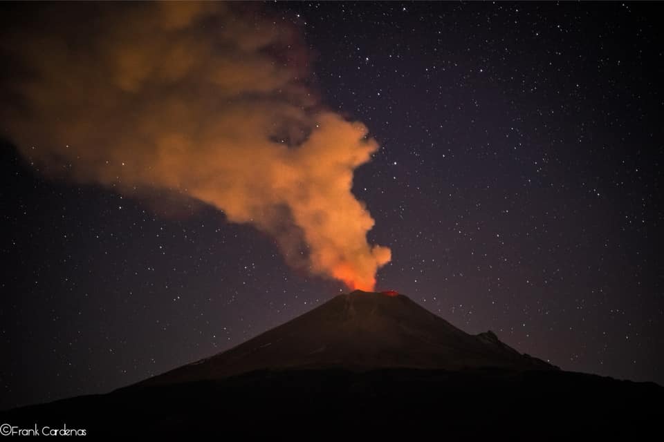
Yesterday, there was a continuous emission of water vapor and other gases that dispersed preferentially to the northwest, and persisted until about 18:00. At the time of writing, emissions of gas dispersed in an east-northeast direction continue.
CENAPRED urges NOT to APPROACH the volcano and especially the crater, because of the risk of falling ballistic fragments, and in case of heavy rains, to move away from the bottom of the ravines because of the risk of landslides and mudslides.
The Popocatepetl volcanic warning light is located at Amarillo Phase 2.
Source : Cenapred.
Photo : Frank Cardenas


No comment yet, add your voice below!