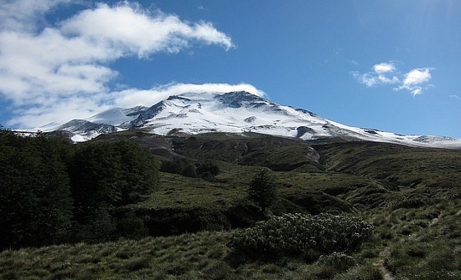
October 19 , 2018. EN. La Réunion : Piton de la Fournaise , Colombia : Nevado del Ruiz , Chile : Puyehue – Cordon Caulle , Costa Rica : Turrialba .

October 19 , 2018.


La Réunion , Piton de la Fournaise : 

Activity Bulletin from Thursday, October 18, 2018 at 17:00 (local time).

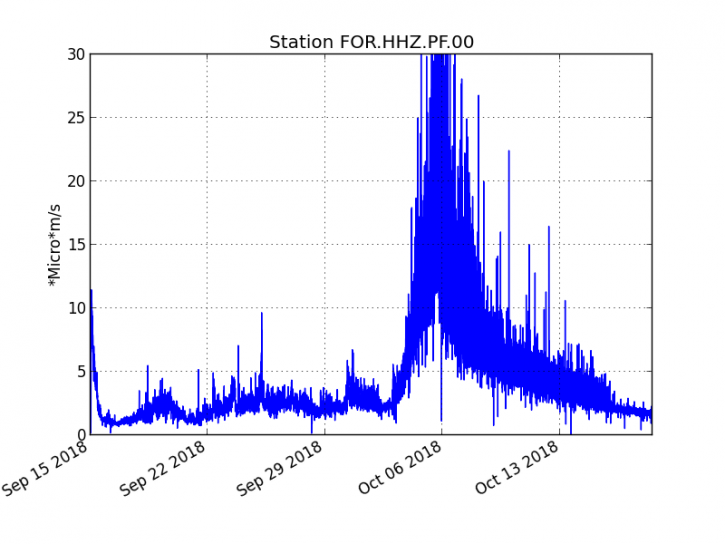
The eruption started on September 15th at 4:25 am local time continues. The intensity of the volcanic tremor (indicator of surface eruptive intensity) is still very slightly decreasing (Figure 1).

Figure 1: Evolution of the RSAM (indicator of the volcanic tremor and the intensity of the eruption) between 04:00 (00h UTC) September 15 and 17:00 (13:00 UTC) October 18 on the seismic station FOR, located near the crater Chateau Fort (2000 m altitude on the southeast flank of the terminal cone). (© OVPF / IPGP)

– No volcano-tectonic earthquake was recorded during the day of 17 October or during the current day.
– Inflation (swelling) of the building is always recorded. This inflation reflects the pressurization of a localized source beneath the summit craters (Bory-Dolomieu) at a depth of 1-1.5 km, related to the recharge of the superficial reservoir by deeper magma.
– The surface flow rates could not be estimated today because of lava flows that are too weak at the surface.
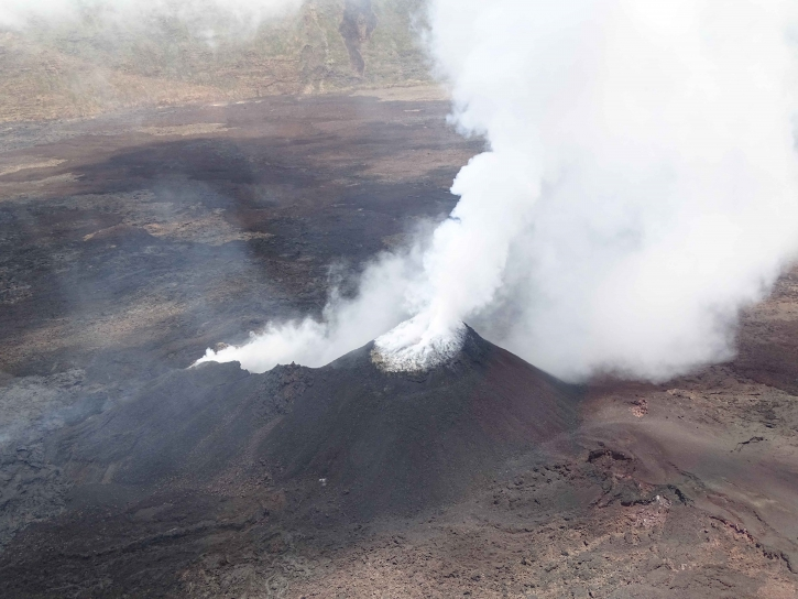
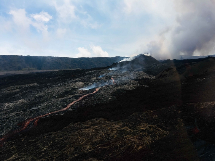
– Field reconnaissance has been completed today. The observations show a surface activity still very limited. Strong degassing is always observed at the eruptive vent (Figure 2). Some resurgences and a small channel of some tens of meters were visible this morning around 11:30 at the foot of the eruptive cone (eastern sector, Figure 3).

Figure 2: Shooting of the eruptive site on October 18 at 11:00 am local time. (© OVPF / IPGP)


Figure 3: Shooting of the eruptive site on October 18 at 11:30 local time. (© OVPF / IPGP)

Alert level: Alert 2-2 – Eruption in the Enclos .

Source : OVPF. http://www.ipgp.fr/fr/ovpf/bulletin-dactivite-jeudi-18-octobre-2018-a-17h00-heure-locale


Colombia , Nevado del Ruiz :

Subject: Activity bulletin of the Nevado del Ruiz volcano.
The level of activity continues at the level: Yellow activity level or (III): changes in the behavior of volcanic activity.

With regard to monitoring the activity of the Nevado del Ruiz volcano, the COLOMBIAN GEOLOGICAL SERVICE announces that:

During the past week, the seismicity caused by the fracturing of the rocks that make up the volcano showed similar behavior with respect to the number of earthquakes and a slight increase in seismic energy released compared to the previous week. The earthquakes were mainly located in the Southeast, Northeast and Arenas crater zones, at depths between 0.5 and 5.0 km. The maximum magnitude recorded during the week was 1.3 ML (local magnitude), corresponding to earthquakes recorded on October 12 at 20:04 (local time) and 13 October at 10:43 (local time) in the southeast source at 3.9 km deep and in the crater Arenas to 1.8 km deep, respectively.

Seismicity related to fluid dynamics, within the channels of the volcanic structure, showed a similar level of the number of earthquakes and a slight increase in seismic energy released compared to the previous week. This activity was characterized by the presence of earthquakes of variable energy levels, type of long period (LP), very long period (VLP), pulsations of volcanic tremor and episodes of continuous volcanic tremor. The earthquakes were mainly located in the crater Arenas and its surroundings.

Volcanic deformations measured from electronic inclinometers, GNSS (Global Navigation Satellite System) stations and radar images have so far shown stability behavior without recording significant deformation processes of the volcanic structure.

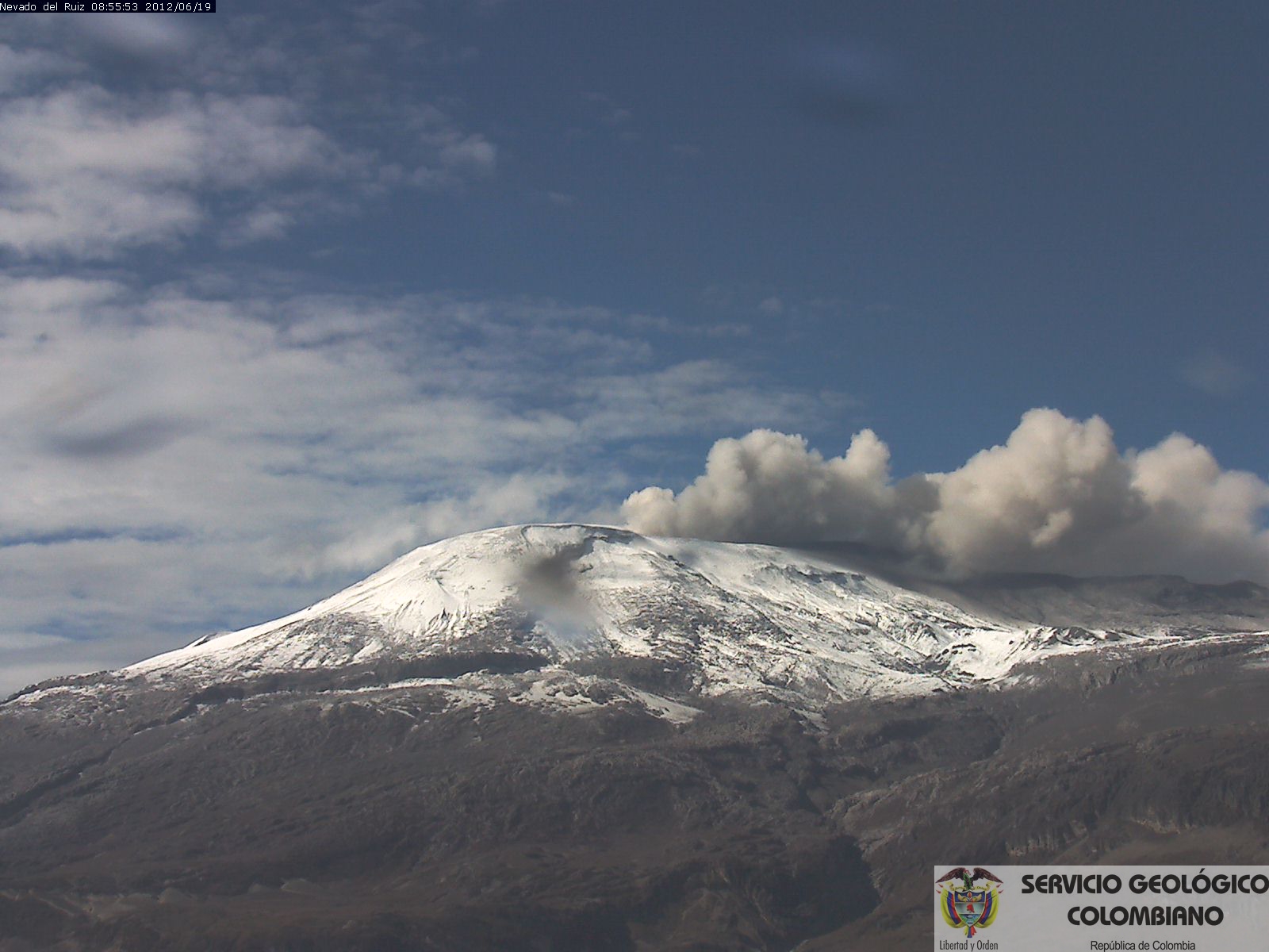
The volcano continues to emit into the atmosphere water vapor, ash and gases, among which is the sulfur dioxide (SO2). During the week, the NASA FIRMS portal reported several thermal anomalies of very low energy.

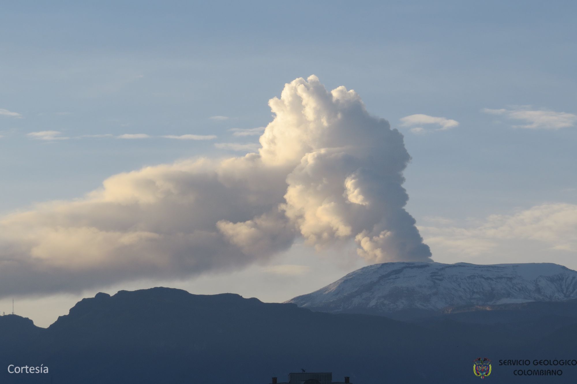
The column of gas, steam and ash reached a maximum height of 1300 m, measured at the top of the volcano on October 10. The direction of column dispersion was governed by the direction of the wind in the area, which dominated during the week to the northeast and southeast, from the Arenas crater.

The Nevado del Ruiz volcano continues at the level of yellow activity.

Source : SGC.

Photos : Archives SGC.


Chile , Puyehue – Cordon Caulle :

During the period evaluated, a total of 125 seismic events were recorded, of which 2 were classified as long period (LP), in relation to the dynamics of the fluids within the volcanic edifice. The event of greater energy had a reduced displacement value (DRc) equal to 4.8 cm2. Also, 123 volcano-tectonic earthquakes (VT), associated with fracturing processes of rocks, were recorded. The event of greatest energy had a local magnitude (ML) equal to M 1.4, and was located 5.8 km southeast of the emission center of 2011, at a depth of 3.6 km.

The images provided by the IP cameras installed around the volcano do not show any superficial changes.

According to the data provided by three GNSS stations, we observe that the inflationary process reported previously is continuing. The maximum rate of horizontal variation recorded by the permanent network is 0.5 cm / month and the vertical rate of 0.9 cm / month for the station closest to the point of maximum deformation. It should be noted that the direction of the displacement has changed compared to the previous trend, this produced by the possible migration of the source which is at the origin of this deformation.

No sulfur dioxide (S02) emissions have been reported in the area’s atmosphere near the volcanic building, according to data published by the Ozone Observatory Sulfur Dioxide Group (http: // mon2.gsfc.nasa.gov/). ) and the National Information and Satellite Data Service on the Environment (NESDIS) (http://satepsanoine.nesdis.noaa.gov).

No thermal warning was reported in the area associated with the volcanic complex during the period, according to data processed by the mean infrared observation of volcanic activity (MIROVA) (http://www.mirovaweb.it /) and Temporal Thermal Monitoring of global hot spots (MODVOLC) (http://modis.higp.hawaii.edu/).

The low energy of the seismicity as the small occurrence of earthquakes in relation to the activity, despite the deformation observed in relation to the presence of a residual magmatic body, and relatively superficial set up during the eruption of 2011, presents uniform behavior indicating relative stability of the volcanic system.

Due to the above, the volcanic warning is reduced to the level:
GREEN LEVEL: Changes in the behavior of volcanic activity – Probable time for an eruption: WEEKS / MONTH.

Source : Sernageomin


Costa Rica , Turrialba :

Turrialba Volcano Activity Report, 18 October 2018.

On October 18, 2018 at 09:24 local time, there is an eruption on the volcano Turrialba, the height reached by the column is unknown because of the visibility conditions of the site.
Duration of the activity: 1 minute.
The winds were blowing towards the Southwest.

Ash fall reported in: At this time, no ash drop has been reported.
Sulfur odor reported in: At this time, no sulfur odor was reported.

Comments: The cloudy conditions at the top of Turrialba volcano did not allow to appreciate the height of the plume of ash and gas of the eruption. The materials are dispersed by the prevailing wind towards the region south-southwest of the volcano.

Since October 10, 2018, the volcano Turrialba is erupting continuously. The column rises to 3,340 meters above sea level. (10955.2 ft).
The seismic activity is more important than yesterday.
At the time of this report, the winds are blowing east.
Passive semi-constant emissions are continued. Visual webcam observations are low due to ash and weather conditions.

Source : Ovsicori.

Photo : Archive RSN
19 Octobre 2018. FR . La Réunion : Piton de la Fournaise , Colombie : Nevado del Ruiz , Chili : Puyehue – Cordon Caulle , Costa Rica : Turrialba .

19 Octobre 2018.


La Réunion , Piton de la Fournaise : 

Bulletin d’activité du jeudi 18 octobre 2018 à 17h00 (Heure locale) .

L’éruption débutée le 15 septembre à 04h25 heure locale se poursuit. L’intensité du trémor volcanique (indicateur de l’intensité éruptive en surface) est toujours en très légère baisse (Figure 1).


Figure 1 : Evolution du RSAM (indicateur du trémor volcanique et de l’intensité de l’éruption) entre 04h00 (00h UTC) le 15 septembre et 17h00 (13h00 UTC) le 18 octobre sur la station sismique FOR, localisée à proximité du cratère Château Fort (2000 m d’altitude sur le flanc sud-est du cône terminal). (© OVPF/IPGP)

– Aucun séisme volcano-tectonique n’a été enregistré au cours de la journée du 17 octobre, ni au cours de la journée actuelle.
– Une inflation (gonflement) de l’édifice est toujours enregistrée. Cette inflation témoigne de la mise en pression d’une source localisée sous les cratères sommitaux (Bory-Dolomieu) à 1-1,5 km de profondeur, liée à la réalimentation du réservoir superficiel par du magma plus profond.

– Les débits en surface n’ont pas pu être estimés ce jour du fait de flux laviques trop faibles en surface.
– Une reconnaissance de terrain a pu être réalisée ce jour. Les observations font état d’une activité de surface toujours très limitée. Un fort dégazage est toujours observé au niveau de l’évent éruptif (Figure 2). Quelques résurgences et un petit chenal de quelques dizaines de mètres étaient visibles ce matin aux alentours de 11h30 au pied du cône éruptif (secteur est ; Figure 3).


Figure 2 : Prise de vue du site éruptif le 18 octobre à 11h00 heure locale. (© OVPF/IPGP)


Figure 3 : Prise de vue du site éruptif le 18 octobre à 11h30 heure locale. (© OVPF/IPGP)

Niveau d’alerte : Alerte 2-2 – Eruption dans l’Enclos.

Source : OVPF. http://www.ipgp.fr/fr/ovpf/bulletin-dactivite-jeudi-18-octobre-2018-a-17h00-heure-locale


Colombie , Nevado del Ruiz :

Objet: Bulletin d’activité du volcan Nevado del Ruiz.
Le niveau d’activité continue au niveau: Niveau d’activité jaune ou (III): changements dans le comportement de l’activité volcanique.

En ce qui concerne le suivi de l’activité du volcan Nevado del Ruiz, le SERVICE GÉOLOGIQUE COLOMBIEN annonce que:

Au cours de la semaine écoulée, la sismicité causée par la fracturation des roches qui composent le volcan a montré un comportement similaire en ce qui concerne le nombre de séismes et une légère augmentation de l’énergie sismique libérée par rapport à la semaine précédente. Les séismes ont été localisés principalement dans les zones Sud-Est, Nord-Est et dans le cratère Arenas, à des profondeurs comprises entre 0,5 et 5,0 km. La magnitude maximale enregistrée au cours de la semaine était de 1,3 ML (magnitude locale), correspondant aux séismes enregistrés le 12 octobre à 20h04 (heure locale) et le 13 octobre à 10h43 (heure locale) dans la source Sud-Est à 3,9 km de profondeur et dans le cratère Arenas à 1,8 km de profondeur, respectivement.

La sismicité liée à la dynamique des fluides, à l’intérieur des canaux de la structure volcanique, a montré un niveau similaire du nombre de séismes et une légère augmentation de l’énergie sismique libérée par rapport à la semaine précédente. Cette activité était caractérisée par la présence de séismes de niveaux d’énergie variables , type de longue période (LP),  très longue période (VLP), de pulsations de tremor volcanique et d’épisodes de tremor volcanique continu. Les tremblements de terre ont été localisés principalement dans le cratère Arenas et ses environs. 

Les déformations volcaniques mesurées à partir d’inclinomètres électroniques, de stations GNSS (système mondial de navigation par satellite) et d’images radar montrent jusqu’à présent un comportement de stabilité sans enregistrer de processus de déformation importants de la structure volcanique.

Le volcan continue d’émettre dans l’atmosphère des vapeurs d’eau, des cendres et des gaz, parmi lesquels se distingue le dioxyde de soufre (SO2). Au cours de la semaine, le portail NASA FIRMS a signalé plusieurs anomalies thermiques de très basse énergie.

La colonne de gaz, de vapeur et de cendres a atteint une hauteur maximale de 1300 m, mesurée au sommet du volcan, le 10 octobre. La direction de la dispersion de la colonne était régie par la direction du vent dans la région, qui dominait pendant la semaine vers le Nord-Est et le Sud-Est, par rapport au cratère Arenas.

Le volcan Nevado del Ruiz continue au niveau d’activité jaune.

Source : SGC.

Photos : Archives SGC.


Chili , Puyehue – Cordon Caulle :

Durant la période évaluée , il a été enregistré un total de 125 évènements sismiques parmi lesquels 2 ont été classés comme étant de type longue période (LP), en relation avec la dynamique des fluides à l’intérieur de l’édifice volcanique . L’évènement de plus grande énergie présentait une valeur de déplacement réduit ( DRc) égale à 4,8 cm2.Egalement , il a été enregistré 123 séismes de type volcano-tectoniques ( VT) , associés à des processus de fracturation de roches . L’évènement de plus grande énergie présentait une magnitude locale (ML) égale à M 1,4 , et était localise à 5,8 km au Sud-Est du centre d’émission de 2011 , à une profondeur de 3,6 km .

Les images fournies par les caméras IP installées autour du volcan ne montrent pas de changements superficiels.

Selon les données fournies par trois stations GNSS , on observe que le processus inflationniste rapporté précédemment se poursuit. Le taux maximal de variation horizontale enregistré par le réseau permanent est de 0,5 cm / mois et le taux vertical de 0,9 cm / mois pour la station la plus proche du point de déformation maximale. Il faut signaler que la direction du déplacement à changé par rapport à la tendance antérieure , ceci produit par la possible migration de la source qui est à l’origine de cette déformation .

Aucune émission de dioxyde de soufre (S02) n’a été signalée dans l’atmosphère du secteur près du bâtiment volcanique, selon les données publiées par le Groupe sur le dioxyde de soufre de l’Observatoire de l’ozone (http://mon2.gsfc.nasa.gov/). ) et le service national d’information et de données satellitaires sur l’environnement (NESDIS) (http://satepsanoine.nesdis.noaa.gov).

Aucune alerte thermique n’a été signalée dans la zone associée au complexe volcanique au cours de la période, selon les données traitées par l’observation en infrarouge moyen de l’activité volcanique (MIROVA) (http://www.mirovaweb.it/) et par la Surveillance thermique temporelle des points chauds globaux (MODVOLC) (http://modis.higp.hawaii.edu/).

La basse énergie de la sismicité comme la petite occurrence de séismes en relation avec l’activité  , malgré la déformation observée en relation avec la présence d’un corps magmatique résiduel, et  relativement superficiel  mis en place lors de l’éruption de 2011, présente un comportement uniforme indiquant une relative stabilité du système volcanique ..

En raison de ce qui précède, l’avertissement volcanique est ramené au niveau:
NIVEAU VERT: Changements dans le comportement de l’activité volcanique – Temps probable pour une éruption: SEMAINES / MOIS.

Source : Sernageomin


Costa Rica , Turrialba :

Rapport d’activité du volcan Turrialba, 18 Octobre 2018 .

Le 18 Octobre 2018 à 09h24 heure locale, il y a une éruption sur le volcan Turrialba, la hauteur atteinte par la colonne est inconnue en raison des conditions de visibilité du site.
Durée de l’activité:  1 minute.
Les vents soufflaient vers le Sud-Ouest.

Chute de cendres rapportée dans: À ce moment précis, aucune chute de cendres n’a été signalée.
Odeur de soufre signalée dans: À ce moment précis, aucune odeur de soufre n’a été signalée.

Commentaires: Les conditions nuageuses au sommet du volcan Turrialba n’ont pas permis d’apprécier la hauteur du panache de cendres et de gaz de l’ éruption. Les matériaux sont dispersés par le vent dominant en direction de la région située au Sud-Sud-Ouest du volcan.

Depuis le 10 octobre 2018, le volcan Turrialba est en éruption continue. La colonne monte à  3 340 mètres au-dessus du niveau de la mer.  (10955.2 ft).
L’activité sismique est plus importante qu ‘hier.
Au moment de ce rapport, les vents soufflent à l’Est.
Les émissions passives semi-constantes sont poursuivies. Les observations visuelles par webcam sont peu nombreuses en raison des cendres et des conditions météorologiques.

Source : Ovsicori.

Photo : Archive RSN