
August 29 , 2018.
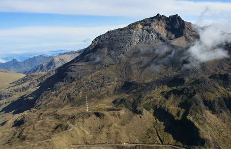
Peru , Sabancaya :
An average of 25 Eplosions / day was recorded. The earthquakes associated with the rise of the magma (hybrid type) remain very few and not very energetic. Eruptive columns of gas and ash reached a maximum height of 4500 m above the crater. The dispersion of these materials occurred within a radius of approximately 50 km, mainly in the North, Northeast, East and Southeast directions. Ash falls have been reported in Pinchollo, Achomay Yanque.

The volcanic gas flow (SO2) recorded on 25 August a maximum value of 2230 tons / day, a value considered important.
The deformation of the surface of the volcanic building presents a trend associated with an inflationary process.
The MIROVA satellite system recorded 7 thermal anomalies, with values ranging from 1 MW to 66 MW VRP (Radiated Volcano Power).
In general, eruptive activity maintains moderate levels. No significant changes are expected in the following days.
Source : IGP
Photo : Ingemmet.
Colombia , Chiles / Cerro Negro :
The level of activity of volcanoes remains at the level of: ■ LEVEL YELLOW (III): Changes in the behavior of volcanic activity
Following the activity of VOLCANS CHILES and CERRO NEGRO, the COLOMBIAN GEOLOGICAL SERVICE (SGC) reports that:
During the evaluation period, between 21 and 27 August 2018, seismicity in the region of Chiles – Cerro Negro volcanoes decreased slightly in number and energy compared to the previous week, from 591 to 527 earthquake. These earthquakes corresponded almost entirely to rock fracture processes in the volcanic building.
The earthquakes have their epicentres located to the south and south-west of the Chiles volcano, with distances of less than 9.5 km, depths between 1 and 11 km for the upper Chiles volcano (4700 m). Most earthquakes recorded a local magnitude not exceeding M 1.7 on the Richter scale. The largest earthquake occurred on 21 August at 01:22, located 5.2 km southwest of the Chiles volcano, with a depth of 5 km and a magnitude of M2.5, which was not reported as felt.
The Colombian Geological Survey and the Ecuador NATIONAL POLYTECHNICAL Geophysical Institute closely monitor the evolution of this seismic and volcanic activity and will report immediately on the changes detected.
Source : SGC
Costa Rica , Turrialba / Poas :
Daily report on the state of volcanoes. OVSICORI-UNA
Date: 2018-08-28
Updated at: 11:09:00.
Turrialba Volcano
Since 27 August 2018, a continuous eruption has occurred on the Turrialba volcano, with a column rising 200 meters above the crater and 3540 meters above sea level (11611.2 feet).
The seismic activity is lower than yesterday.
At the time of this report, the winds are blowing towards the Southwest.
The Turrialba volcano is maintained with sporadic, passive eruptions, with small columns of gas and diluted ash. LP-type earthquakes persist with short and spaced tremors.
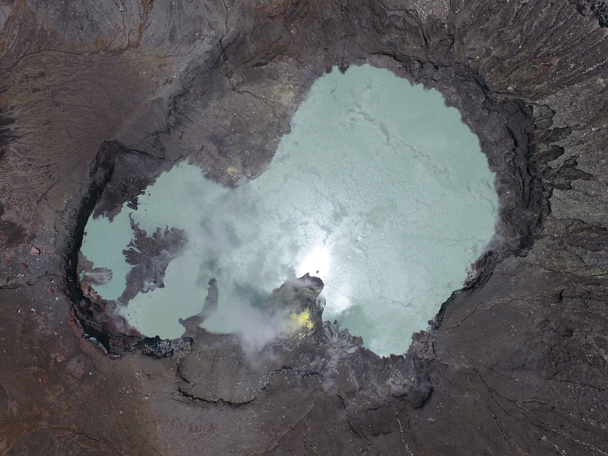
The new Laguna Caliente of the Poás volcano.
Poas Volcano:
No eruptions are reported.
The seismic activity is similar to that of yesterday.
At the time of this report, the winds are blowing towards the Southwest.
The volcano is maintained with a continuous bottom tremor and LP type earthquakes
Source : Ovsicori.
Photo : Sergio Paz via Raul Mora-Amador.
Philippines , Kanlaon :
KANLAON VOLCANO BULLETIN 28 August 2018 08:00 A.M.
Kanlaon Volcano’s seismic monitoring network recorded four (4) volcanic earthquakes during the past 24 hours. Weak to moderate emission of white steam-laden plumes that rose 600 meters from the summit before drifting northwest to northeast was observed. Ground deformation data from continuous GPS measurements indicate a more pronounced inflation of the edifice since December 2017, signifying pressurization beneath the edifice. Sulfur dioxide (SO2) emission was measured at an average of 955 tonnes/day on 23 August 2018.

Alert Level 2 status prevails over Kanlaon Volcano, which means that the volcano is undergoing a moderate level of unrest due to probable intrusion of magma at depth that may or may not lead to a magmatic eruption. The local government units and the public are strictly reminded that entry into the 4-kilometer radius Permanent Danger Zone (PDZ) is strictly prohibited due to the further possibilities of sudden and hazardous steam-driven or phreatic eruptions. Civil aviation authorities must also advise pilots to avoid flying close to the volcano’s summit as ejecta from any sudden phreatic eruption can be hazardous to aircraft.
DOST-PHIVOLCS is closely monitoring Kanlaon Volcano’s activity and any new development will be relayed to all concerned.
Source : Phivolcs


No comment yet, add your voice below!