
August 21 , 2018.
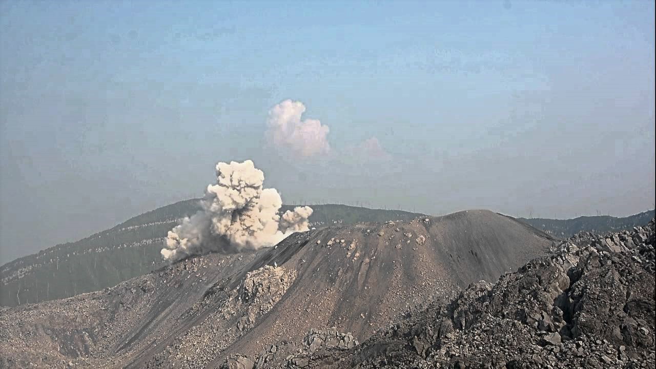
Peru , Sabancaya :
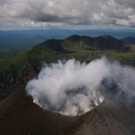
An average of 27 EXP / day was recorded. There was a slight increase in seismic activity associated with the movement of fluids (long period type). Earthquakes associated with the rise of magma (hybrid types) remain very few and low energy.
The gas columns and eruptive ash reached a maximum height of 3700 m above the crater. The dispersion of these materials occurred within a radius of approximately 50 km, mainly in the Southeast, East and Northeast directions.
Ingemmet specialists ride on Sabancaya in Arequipa. They install a multi-gas station to monitor the volcano and explain that if the gas increases, a big explosion could take place.
The volcanic gas flow (SO2) recorded on August 19 a maximum value of 3100 tons / day, considered a significant value.
The deformation of the surface of the volcanic building presents important variations.
The MIROVA satellite system recorded 9 thermal anomalies, with values between 1 MW and 17 MW VRP (Radiated Volcano Power).
In general, eruptive activity maintains moderate levels. No significant changes are expected in the following days.
Source : IGP Peru
Vidéo : Radio Yaravi Arequipa
Indonesia , Ibu :
Level of Activity at Level II (WASPADA). G. Ibu (1340 m) has been continuously erupting since 2008.
Since yesterday and until this morning, visually, the summit of the volcano could be observed clearly until it was covered with fog. The crater eruption smoke and ash was white / gray, with low to moderate intensity up to 200-1200 m above the peak. The wind is blowing weakly to the northeast.
According to the seismographs, on August 20, 2018, it was recorded:
142 earthquakes of eruptions
201 earthquakes
60 avalanche earthquakes.
1 harmonic tremor
1 distant earthquake
Recommendation: People around G.Ibu and visitors / tourists should not move, climb or approach within 2 km with a sectoral expansion of 3.5 km north of the active crater G. Ibu.
VOLCANO OBSERVATORY NOTICE FOR AVIATION – VONA.
Issued: August 20 , 2018.
Volcano: Ibu (268030)
Current Aviation Colour Code: ORANGE
Previous Aviation Colour Code: orange
Source: Ibu Volcano Observatory
Notice Number: 2018IBU13
Volcano Location: N 01 deg 29 min 17 sec E 127 deg 37 min 48 sec
Area: North Maluku, Indonesia
Summit Elevation: 4240 FT (1325 M)
Volcanic Activity Summary:
Eruption with volcanic ash cloud at 08h42 UTC (17h42 local).
Volcanic Cloud Height:
Best estimate of ash-cloud top is around 8080 FT (2525 M) above sea level, may be higher than what can be observed clearly. Source of height data: ground observer.
Other Volcanic Cloud Information:
Ash cloud moving to North.
Remarks:
Seismic activity is charcterized with explosion and rock avalanche earthquakes. Eruption is continuing.
Source : PVMBG , Magma Indonésie.
Photo : André Labetaa ( U Tube , 2015 ).
Guatemala , Santiaguito :
Type of activity: Peléan.
Morphology: Complex of dacitic domes
Geographical location: 14 ° 44 ’33 ˝ Latitude N; 91 ° 34’13˝ Longitude W.
Height: 2,500msnm.
Weather Conditions: Partly Cloudy
Wind: East at 5 km / h
Precipitation: 22.7 mm
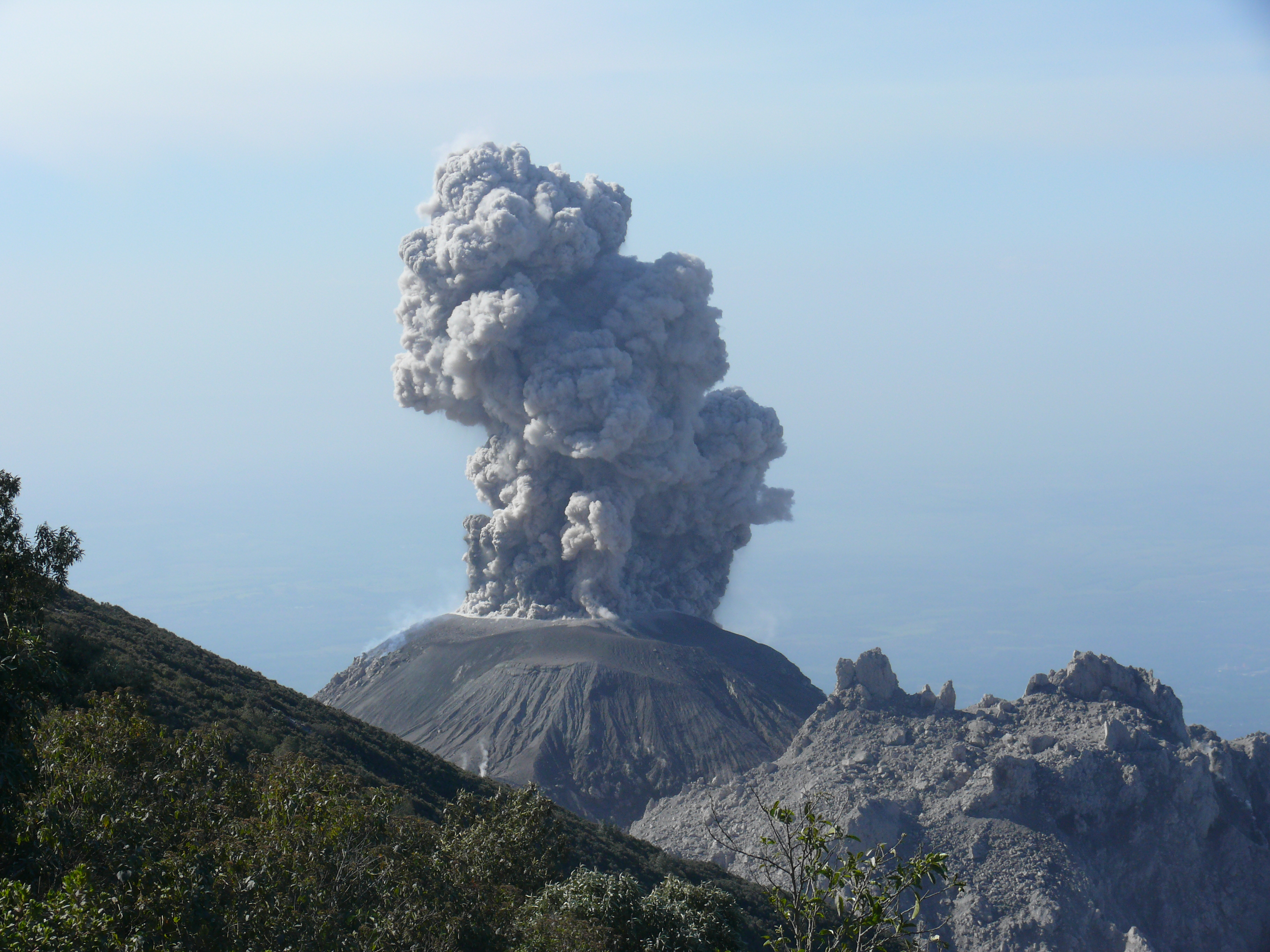
Activity:
Presence of a white degassing at 2900 meters altitude that the wind disperses in the South-West. The OVSAN reports six weak, early-morning, early-morning explosions that reveal columns of white ash at 3300 meters with a southwesterly dispersion. There are falls of fine ash particles in the volcanic perimeter, and a small number of weak avalanches on the south-east flank.
Source : Insivumeh.
Photo : Wanderreise Février 2009
Italie , Vesuvius :
Vesuvius, 79 d.C. Chronicle of an eruption. by Maddalena De Lucia, Mauro Di Vito and Giovanni Orsi
It’s dark A dense ash falls. This removes the breath and prevents the leak. Terror, panic everywhere and despair. It seems like the end of the world. It was thus that Pompeii, Herculaneum, Boscoreale, Stabia and Oplontis disappeared, in the year 79, buried in the ashes and destroyed by pyroclastic flows, because of an eruption of the Plinian of Vesuvius, the volcano that seemed just a mountain, like those around it. There, in the dark, under a thick layer of volcanic products, the Roman cities and their inhabitants remained sealed for nearly two thousand years. The remains visible today are a perfect snapshot of the life and culture of these thriving cities, but at the same time are a testament to the destructive power of the volcano and a warning for good land use.
With a strong earthquake on February 5, 62 AD, Vesuvius had already given signs of its awakening. After that, many others followed, increasing a few days before the eruption and accompanied by deformations of the soil. Despite this, the eruption that occurred after a few centuries of rest by Vesuvius surprised the people who had settled in the region. The Vesuvians did not imagine that these phenomena were the precursors of an eruption and that their green mountain was actually a volcano (Figure 1).
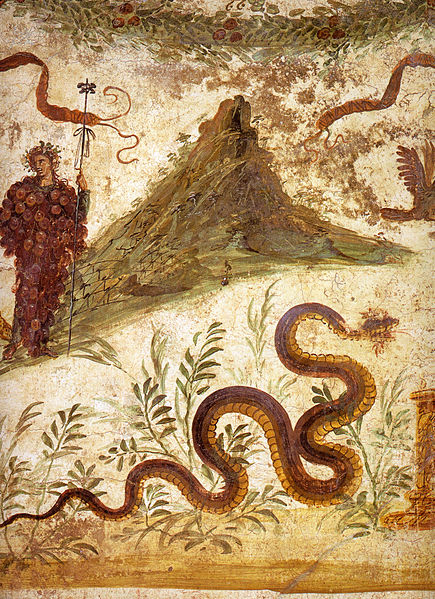
Figure 1 – Fresco of the centenary house in Pompeii, currently in the National Archaeological Museum of Naples. The mountain represented is probably Vesuvius as it appeared before the eruption of 79 AD. (source of the image: https://it.wikipedia.org/wiki/File:Pompeii_-_Casa_del_Centenario_-_MAN.jpg).
The eruption began with a series of phreatomatic explosions that caused the opening of the terminal part of the eruptive duct. A large quantity of ash, lapilli and volcanic bombs fell to the ground, mainly in areas east of the crater. After a few hours, more violent magmatic explosions – generated by the large amount of gas present in the magma – fed for about twelve hours an eruptive column which reached about thirty kilometers (no original iconographic documents, example of column : a similar eruption, that produced in 1991 by the Pinatubo volcano in the Philippines, Figure 2).
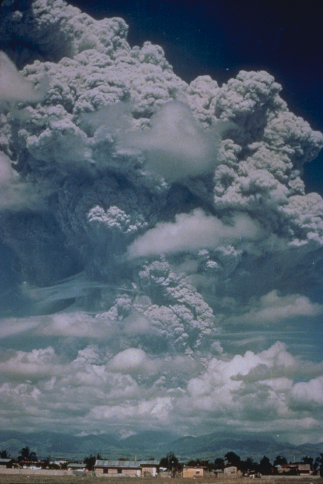
Figure 2 – Eruptive column produced during the eruption of the Pinatubo volcano in the Philippines in 1991 (source: US National Oceanic and Atmospheric Administration). The photo reproduces a recent example of eruption with similar characteristics to that of 79 AD.
Pline le Jeune observed the eruption from Miseno and described it in a letter to Tacitus: « The cloud has risen, we did not know for sure which mountain, because we looked from a distance, only later we knew that this mountain was Vesuvius, its shape was like that of a pine tree more than any other tree.From a huge trunk, the cloud stood high in the sky and expanded almost into branches. 3).
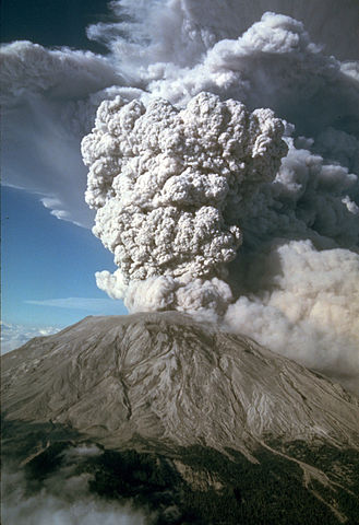
Figure 3 – Eruptive column produced during the eruption of Mount St. Helens in the United States in 1980 (source image: US Geological Survey). The photo shows a recent example of eruption with similar characteristics to the eruption of Vesuvius in 79 AD.
The upper part of the column, which extended like the crown of a pine, was pushed by the wind towards the South-East. The fall of the solid particles it contains, essentially pumice and ash, completely obscures the sky, making the escape difficult and frightening. A thick deposit has accumulated over a very large area. Pompeii and Oplonti were partially buried under about three meters of pumice stone; under their weight, the roofs of the houses began to collapse and the first victims were found.
The partial collapse of the eruption column formed a pyroclastic flow that sank at high speed along the flanks of the volcano and reached and destroyed Herculaneum, but not Pompei, much further away. During the night, eruptive activity decreased in intensity. Many of the Pompeians who had fled returned home to collect valuables. A recent example of massive pyroclastic currents generated by an explosive eruption comes from the eruption of the Mayon volcano in the Philippines in 1984 (Figure 4)
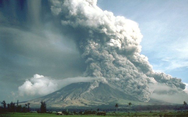
Figure 4 – Pyroclastic flows produced during the Mayon volcano eruption in the Philippines in 1984 (source: US Geological Survey).
In the early hours of the morning, violent pheo-magmatic explosions – caused by the interaction of the magma with the water of the layer contained in the subsoil – formed a cloud that did not rise in the atmosphere, but generated low-temperature, high-temperature pyroclastic currents. They poured on the sides of the volcano. They were flows of ash, gas and rock fragments very hot, able to move very quickly on the slopes of the volcano. These flows reached the sea in a few minutes and extended for at least fifteen kilometers into the Sarno Plain, destroying Pompeii and killing the survivors who had returned there (Fig. 5).
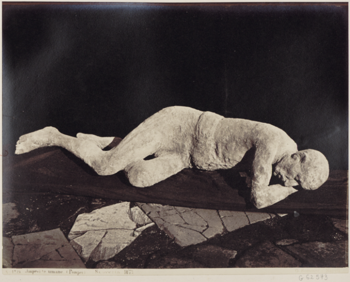
Figure 5 – Plaster cast of human figure in Pompeii. Photograph by Giorgio Sommer, 1873.
Throughout the day, there were explosions of moderate intensity, until, at dusk, the activity diminished rapidly and ended, leaving a thick blanket of pumice and ash over a vast territory. . Subsequently, heavy rains, also caused by the introduction of steam and ash, remobilized the volcanic materials that had just been deposited on the slopes, forming numerous mudslides along the valleys of Vesuvius and the Apennines, devastating the territory further.
The chronicle of the eruption of 79 AD and its effects on the territory was reconstructed through volcanological and archaeological studies and historical documents. The exact date of the eruption, however, is still uncertain: some scholars argue that the eruption occurred on August 24, others lean for autumn, due to the presence of must in barrels and other fruits typically autumnal, as well as the discovery of a piece that would have a later chronological reference. All these elements would reduce the date of 24 August by at least one month.
Source : B. Behncke / Maddalena De Lucia, Mauro Di Vito et Giovanni Orsi : https://ingvvulcani.wordpress.com/2018/08/20/vesuvio-79-d-c-cronaca-di-un-eruzione/
Note from Vulcan’s Cauldron: An exciting and well-researched book on the subject: The Three Days of Pompeii, by Alberto Angela.


No comment yet, add your voice below!