
August 14 , 2018.
Italy / Sicily , Etna :
A volcano is growing before our eyes: the new crater of South-East Etna.
by Boris Behncke
Etna is a Guinness world record volcano. Not only is it the largest and most active volcano in Europe, but it is the second most active – in terms of « productivity » – in the world, after Kilauea in Hawaii. Etna has produced more episodes of lava fountains (« paroxysms ») than any other volcanoes on the planet together, including even the highest lava fountains ever observed in the world (4 September 1999 and 3 December 2015). Among other things that make Etna unique among the volcanoes of the Earth, it should be noted that, in addition to the four craters, this volcano has more than 300 craters on its flanks, which were built during many eruptions. are produced not at the summit but on its slopes. The presence of four craters is unusual, especially since just a century ago – until 1911 – at the top of Etna there was only one crater, the central crater, which is now occupied by two large craters, Voragine and Bocca Nuova.
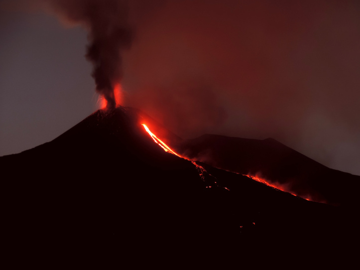
Figure 1. The new crater of the south-east of Etna, with Strombolian activity, a thin column of ash and the emission of a lava flow on the evening of August 12, 2014. The view is from Santa Venerina, on the south-east side of the volcano. Picture of Boris Behncke
In recent years, the morphology of the summit has become even more complex with the formation of the new south-east crater (Fig. 1). The last born, the « little brother » of the crater of South-East, in the South-East part of the summit of the volcano is certainly the most fascinating of all the craters of Etna. The history of this crater begins in 2007 with the opening of a subsidence depression on the east flank of the Southeast Crater. Already, between 4 and 5 September 2007, this mouth produces its first paroxysmal episode with high lava fountains and columns of ash and lapilli, with an exceptional duration of 10 hours (typically the paroxysmal episodes of Etna last less than an hour now). Two other paroxysms followed on November 23 and 24, 2007 and May 10, 2008. The lateral eruption of May 2008 – July 2009 interrupts the activity of the summit, but already in November 2009, a second depression opened at the edge. from the 2007 summit, which, during a series of collapses in 2010, joined the first in a single huge crater (« pit crater », Fig. 2a).
At the end of December 2011, signs of eruptive activity in the « pit crater » on the eastern flank of the Southeast Crater are again noticed. Shortly after, on the night of January 11 to 12, 2011, a series of breakthroughs begins, which, in the years that follow, will lead to the rapid growth of a new cone next to the crater of Southeast , unofficially called « New Southeast Crater ». The researchers of the INGV-Osservatorio Etneo have followed the evolution of this new volcanic structure, which is nothing more than a small stratovolcano, through repeated field surveys, aerial photos and satellite images. , to document the growth of the new cone.
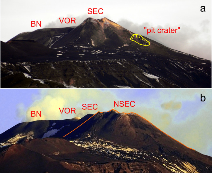
Figure 2. View of the Etna summit area from the South in January 2011 (a) and January 2018 (b). What at the time of the first photo was still known as « pit crater » has become a huge complex of several cones superimposed, the New crater of the Southeast (NSEC), which largely erased the « old » Southeast Crater (SEC). On the left, the craters of Voragine (VOR) and Bocca Nuova (BN). Photo of Boris Behncke.
The activity from 2011 to 2017 consisted of 60 eruptive episodes, many of which showed remarkable explosive intensity (Figure 3), often with lava fountains, which in some cases exceeded 1,000 m. height, and eruptive columns several kilometers high. Conversely, other episodes were characterized by a very violent Strombolian activity, but never passed to supported lava fountains. The most explosive event in the series of breakthrough episodes was November 23, 2013, the only episode that did not produce significant lava flows. The lava flows emitted during the other paroxysms reached lengths of 1 to 4.7 km, expanding to the south, south-east, east and north-east. At present (July 2018), the most recent eruptive period of the New Southeast Crater took place between late January and late April 2017, and built a small cone over the « saddle » which separated from the south-east crater of the new (Fig. 2b).
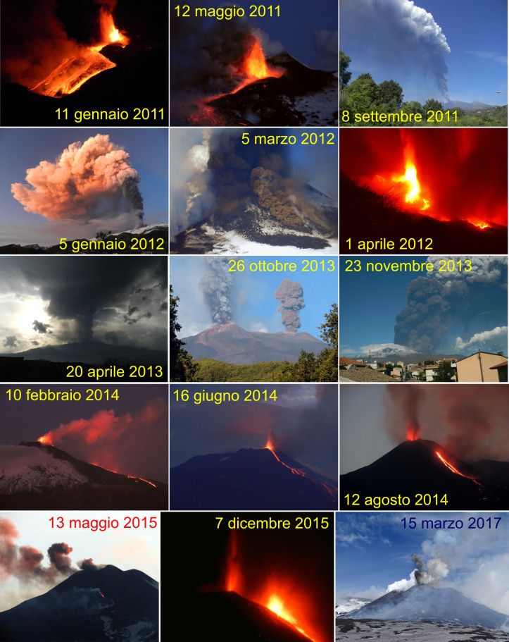
Figure 3. Some scenes of the activity of the new crater of the southeast between 2011 and 2017. It should be noted that during the first three years, the activity was often highly explosive while in the following years Above all, it has been characterized by modest, sometimes violent, strombolian explosions. Photo of Boris Behncke.
Various methods have been applied to lava field mapping and morphological variations of the cone itself, with ground-based GPS measurements, using aerial photos and surveillance camera shots from the INGV. Osservatorio Etneo. From 2017, we also use remotely piloted aircraft or APRs (commonly known as drones). Other measurements were made using satellite data to determine eruption rates during eruptive activity and to create Digital Terrain Models (DEMs). Data were reported on a GIS system to obtain eruption product volumes and eruption rates for each of the eruptive episodes during the 2011 to 2017 period. It was therefore possible to calculate a volume of about 50 million cubic meters for the cone of the new southeastern crater, while the volume of its lava flows is about 150 million cubic meters. The height of the cone is about 215 m above the surface before it was born.
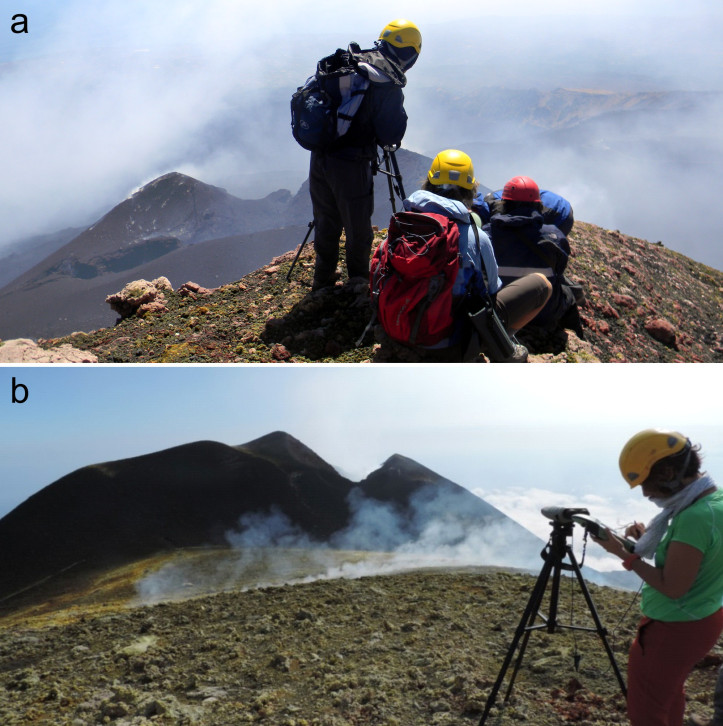
Figure 4. To measure the size and height of the cone of the new south-east crater, the staff of the INGV Etneo Observatory often used GPS instruments connected to laser binoculars, allowing these campaigns to be conducted at a safe distance . . These images were taken at the top of the cone of the « old » crater of the southeast, September 1, 2011 (a) and October 21, 2014 (b). It is evident that the new southeastern crater located between the two images has experienced remarkable growth of about 200 meters. Photo of Boris Behncke.
To fully appreciate the importance of the activity of the new crater of the South-East and its growth, it must however be considered that the cone grew only when of course it was erupting. . The activity spanned 60 eruptive episodes, over a period of more than 6 years, but the vast majority of these episodes were of very short duration, often of a few hours. By summing the durations of all the episodes that contributed to the growth of the cone, we reach a total duration of a few weeks: it is therefore justified to affirm that the new crater of the Southeast has developed more rapidly than any volcano ever observed!
Source et bibliographie : Boris Behncke ( https://ingvvulcani.wordpress.com/2018/08/13/un-vulcano-cresce-davanti-ai-nostri-occhi-il-nuovo-cratere-di-sud-est-delletna/ )
Peru , Sabancaya :
An average of 23 EXP / day was recorded. Significant seismic activity has also been observed associated with the emission of gas and ash. Earthquakes associated with the rise of magma (hybrid types) remain very few and low energy.
The eruptive columns of gas and ash reached a maximum height of 2900 m above the crater. The dispersion of these materials occurred within a radius of about 40 km, mainly in the Northeast, East and Southeast directions.

The volcanic gas (SO2) flow recorded on August 9 a maximum value of 2700 tons / day, a value considered important.
The deformation of the surface of the volcanic building does not present any significant variations.
The MIROVA satellite system recorded 5 thermal anomalies, with values between 2 MW and 15 MW VRP (Radiated Volcano Power).
In general, eruptive activity maintains moderate levels. No significant changes are expected in the following days.
Source : IGP
Photo : Ingemmet
Indonesia, Anak Krakatau :
Level of activity at Level II (WASPADA). Anak Krakatau (305 m above sea level) has experienced an increase in volcanic activity since 18 June 2018.
Since yesterday and until this morning, the volcano has been covered with fog. The smoke from the crater can not be observed. At night, it was observed that there were glows over the peak. The wind is blowing weakly to the northwest.

With seismographs of 13 August 2018, it was recorded:
53 eruption earthquake
25 shallow volcanic earthquakes
47 emission earthquake
Recommendations:
People / tourists are not allowed to approach the crater within 2 km of the crater.
VONA:
The last message VONA received the color code ORANGE, published August 2, 2018 at 16:06 WIB, relating to an eruption recorded with a seismogram of maximum amplitude of 32 mm for a duration of about 19 seconds. The height of the eruption column was approximately 405 m above sea level or 100 m above the peak. The column of ash was moving north.
Source : PVMBG
Photo : Oystein Lund Andersen
Vidéo : ABC New
Ambae , Vanuatu :
Vanuatu’s Ambae Island completely evacuated.
Vanuatu’s government says the island of Ambae has been completely evacuated.
The director general of the climate change ministry, which is responsible for disaster management, says all the island’s 10,000 residents are now on Maewo or Santo.

The order to abandon the island came from the government a month ago, after the eruption from the island’s volcano re-intensified, blanketing the island in ash and toxic fumes.
Jesse Benjamin said the government had evacuated more than 3000 people to Santo, and 2,600 people are now on Maewo.
Mr Benjamin said the rest of the people evacuated themselves.
Source : Radio NZ
Photo : Philippe Carillo – Fusion productions Ltd
Guatemala , Pacaya :
Type of activity: Strombolian
Morphology: Composite Stratovolcan
Location: 14 ° 22’50˝ Latitude N; 90 ° 36’00˝ Longitude W.
Height: 2,552msnm.
Weather Conditions: Partly Cloudy
Wind: South
Precipitation: 2.0 mm
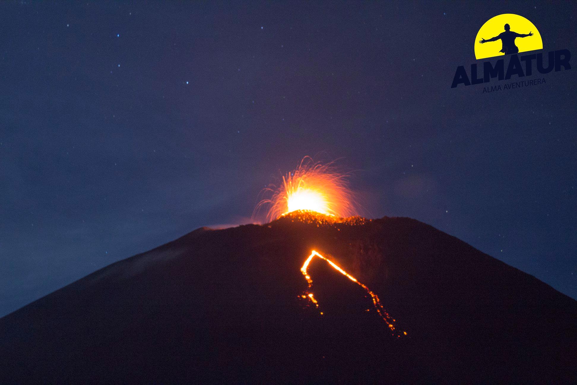
Activity:
Persistence of a weak degassing of white and blue color which amounts to a height approximately 100 meters above the crater and disperses towards the North. At dusk, Strombolian explosions are observed that raise low-level materials. There is a lava flow towards Cerro Chino with an approximate length of 300 meters. The seismic station records the internal tremors associated with constant degassing and explosions generated in the area.
Source : Insivumeh
Photo : Almatur / Sherine France.


No comment yet, add your voice below!